Articles: Special Edition on Years of the Maritime Continent (YMC)
インドネシア・スマトラ島上の日周期降水が総観規模擾乱へ与える影響とマッデン・ジュリアン振動との関係

2021 年 99 巻 1 号 p. 113-137

詳細
2021 年 99 巻 1 号 p. 113-137
The impact of diurnal precipitation over Sumatra Island, the Indonesian Maritime Continent (MC), on synoptic disturbances over the eastern Indian Ocean is examined using high-resolution rainfall data from the Global Satellite Mapping of Precipitation project and the Japanese 55-year Reanalysis data during the rainy season from September to April for the period 2000–2014. When the diurnal cycle is strong, the high precipitation area observed over Sumatra in the afternoon migrates offshore during nighttime and reaches 500 km off the coast on average. The strong diurnal events are followed by the development of synoptic disturbances over the eastern Indian Ocean for several days, and apparent twin synoptic disturbances straddling the equator develop only when the convective center of the Madden–Julian Oscillation (MJO) lies over the Indian Ocean (MJO-IO). Without the MJO, the synoptic disturbances develop mainly south of the equator. The differences in the locations and behaviors of active synoptic disturbances are related to the strength of mean horizontal winds in the lower troposphere. During the MJO-IO, the intensification of mean northeasterly winds in the northern hemisphere blowing into the organized MJO convection in addition to mean southeasterly winds in the southern hemisphere facilitate the formation of the twin disturbances. These results suggest that seed disturbances arising from the diurnal offshore migration of precipitation from Sumatra develop differently depending on the mean states over the eastern Indian Ocean. Furthermore, it is shown that the MJO events with the strong diurnal cycle tend to have longer duration and continuing eastward propagation of active convection across the MC, whereas the convective activities of the other MJO events weaken considerably over the MC and develop again over the western Pacific. These results suggest that the strong diurnal cycle over Sumatra facilitates the smooth eastward propagation of the intraseasonal convection across the MC.
The Indo-Pacific Maritime Continent (MC) consists of numerous islands and seas around the equator and is located in the center of the tropical warm pool. It has been known as the greatest energy source for global atmospheric circulation because significant amounts of heat are released through heavy rainfall (e.g., Ramage 1968). A large-scale ascending air current associated with active convection over the MC constitutes an essential part of the Walker circulation, linking to the El Niño southern oscillation (ENSO) variability (e.g., Yamanaka 2016).
The diurnal cycle is a fundamental mode of tropical atmospheric variability especially over land, driven primarily by insolation. Previous studies have shown that precipitation maxima tend to occur in the late afternoon over land and in the early morning over the open oceans, through analyses of in situ observation data (e.g., Gray and Jacobson 1977), geostationary satellite data (e.g., Albright et al. 1985; Murakami 1983; Nitta and Sekine 1994), and space-borne precipitation radar data (e.g., Takayabu 2002; Nesbitt and Zipser 2003; Kikuchi and Wang 2008), whereas there are some dependencies on regional, topographical, and interannual conditions. Although anomalous dry (wet) conditions are found during El Niño (La Niña) over the MC as a whole, the dependence of the strength of the diurnal cycle of precipitation on ENSO has regional differences because of topography (e.g., Qian et al. 2010, 2013; Rauniyar and Walsh 2013).
The strong diurnal signal over land in the late afternoon has been observed to be spread out over the adjacent oceans during the night (e.g., Yang and Slingo 2001), but the mechanism of the nighttime offshore migration remains elusive. Several studies have focused on the role of gravity waves emanating from convective systems or nighttime radiative cooling over land (e.g., Mapes 2003; Love et al. 2011; Yokoi et al. 2017); others have proposed gravity currents as a cause of the offshore convection through horizontal convergence associated with environmental winds (e.g., Houze et al. 1981; Mori et al. 2004; Yokoi et al. 2019). Yokoi et al. (2017, 2019) examined the diurnal cycle from the data obtained during the two field campaigns in the western coastal region of Sumatra as part of the Years of the Maritime Continent (YMC) project and showed that gravity waves are important in destabilizing the lower troposphere before the arrival of the precipitation area, whereas the vertical shear of horizontal wind near the surface over the coastal waters is another important factor for the migration. In the MC, outstanding diurnal signals accompanied by the nighttime offshore migration were found in the western coast of Sumatra Island (e.g., Mori et al. 2004; Sakurai et al. 2005), in the northwestern coast of Borneo Island (e.g., Houze et al. 1981; Ichikawa and Yasunari 2006), and in New Guinea Island (e.g., Liberti et al. 2001; Zhou and Wang 2006; Ichikawa and Yasunari 2008). Among them, this study focuses on the diurnal signals over and around Sumatra Island.
As the MC convection and its variability play essential roles in the global climate as mentioned above, it seems important for general circulation models (GCMs) to realistically simulate precipitation and convection over the MC. However, these models suffer from significant errors and cannot reproduce the diurnal cycle observed, partly owing to their coarse resolution (e.g., Neale and Slingo 2003; Love et al. 2011). The complex topography including small islands and semi-enclosed seas of the MC cannot be resolved by the GCMs, leading to unrealistic simulations. The difficulty in simulating the diurnal cycle over the MC may influence the reproducibility of another dominant atmospheric mode at intraseasonal time scales in the tropics, which is called the Madden-Julian Oscillation (MJO; e.g., Madden and Julian 1971, 1972, 1994; Zhang 2005). The MJO has been known to propagate eastward around the equator with a period of 30–40 days, accompanied by deep cumulus convection over the warm pool. Although the MJO has been recognized as a planetary scale disturbance, it has a hierarchal structure composed of eastwardpropagating cloud clusters and westward-propagating synoptic disturbances (e.g., Nakazawa 1988). The GCMs have particular difficulty in reproducing the MJO propagation around the MC in addition to their poor representation of the MJO itself. Observational studies have shown that the MJO often weakened and sometimes ceased when it passed over the MC (e.g., Wang and Rui 1990; Matthews 2008). This disruption of the MJO propagation over the MC is known as a barrier effect of the MC and is exaggerated in many GCMs, making the MJO prediction increasingly difficult (e.g., Kim et al. 2009; Seo et al. 2009; Vitart and Molteni 2010). Previous studies have suggested several possible reasons for the MC barrier effect such as the topographic blocking and moisture advection (e.g., Inness and Slingo 2006; Wu and Hsu 2009; Kim et al. 2017; Zhang and Ling 2017). Another possible reason for the MC barrier effect is the interaction between the diurnal cycle and the MJO. Hagos et al. (2016) have shown using a cloud-permitting regional model that the MJO convective signals propagating the MC are stronger in runs without the diurnal forcing than in runs with the diurnal forcing. Majda and Yang (2016) suggested that the diurnal cycle might cause the stalled or suppressed propagation of the MJO across the MC using a simple multiscale model.
It is well known that the MJO acts to modulate the diurnal cycle. However, the phases accompanying the strong diurnal cycle over the MC are still controversial. Several studies have shown that the diurnal cycle over the MC is enhanced during the convectively active phase of the MJO (e.g., Tian et al. 2006; Ichikawa and Yasunari 2007), whereas others have found a pronounced diurnal cycle over the MC during the suppressed phase, just before the arrival of the active phase (e.g., Fujita et al. 2011; Peatman et al. 2014; Birch et al. 2016). Rauniyar and Walsh (2011) have also indicated that the mean and diurnal rainfall over the MC land regions reach their peaks during the suppressed phase, but those over the surrounding seas attain their maxima during the active phase.
Although many previous studies have investigated the modulation of the diurnal cycle over the MC by the MJO, upscale effects of the diurnal cycle remain largely unexplored, especially the effects on synoptic-scale disturbances. As the MJO has a hierarchal structure, as mentioned above, such effects on the synoptic disturbances embedded in the MJO might modulate the MJO itself. This study examines the impact of diurnal precipitation over Sumatra Island on synoptic disturbances over the eastern Indian Ocean, and its relationship to the MJO, using global precipitation datasets.
The rest of this paper is organized as follows. The datasets and methodology are described in Section 2. Section 3 provides the general features of the diurnal events over Sumatra detected in this study. In Sections 4 and 5, the development of synoptic disturbances over the Indian Ocean during the diurnal events and their relationship with the MJO phase and intensity are investigated. The mechanisms responsible for the development of synoptic disturbances are examined in Section 6. The influence of the diurnal events on the MJO propagation is discussed in Section 7. The final section provides a summary.
High-resolution hourly rainfall data with a horizontal resolution of 0.1° obtained from satellite-borne microwave radiometers by the Global Satellite Mapping of Precipitation (GSMaP) project (Kubota et al. 2007; Aonashi et al. 2009) are used to investigate the diurnal cycle for the period March 2000–February 2014. We use the reanalysis version (GSMaP_RNL), which is processed in the same manner as the standard version (GSMaP_MVK ver. 7), but is available for a longer period (Kubota et al. 2020). We focus on the Indonesian rainy season from September to April, defined broadly as there are regional differences within the MC (e.g., Hamada et al. 2002).
Synoptic disturbances and mean states are examined using mean-daily reanalysis data recorded four times daily on 1.25° × 1.25° grids obtained from the Japanese 55-year Reanalysis (JRA55; Kobayashi et al. 2015), provided by the Japan Meteorological Agency. Zonal and meridional winds (u and v), vertical velocity (ω), pressure (p), temperature (T), and geopotential (Φ) at pressure levels from 1000 hPa to 100 hPa are used. In addition, daily optimum interpolation SST high-resolution datasets, provided by the National Oceanic and Atmospheric Administration (NOAA)/Office of Oceanic and Atmospheric Research/Earth System Research Laboratory, Physical Sciences Division, on 0.25° × 0.25° grids (Reynolds et al. 2007) are used.
As a proxy for large-scale convective activities associated with the MJO, NOAA daily outgoing longwave radiation (OLR) data on 2.5° × 2.5° grids (Liebmann and Smith 1996) are used. For the MJO index, an all-season real-time multivariate MJO (RMM) index (Wheeler and Hendon 2004) is applied, which is composed of a leading pair of empirical orthogonal functions combining the fields of near-equatorial OLR and zonal winds in the lower and upper troposphere. The amplitude and phases of the MJO are determined using the pair of principal component time series, RMM1 and RMM2. The MJO events in this study are identified when the amplitude of the RMM index exceeds 1.0 for 15 consecutive days. The average amplitude of the RMM index over the rainy season (September–April) of the study period (March 2000–February 2014) is 1.29 and the standard deviation is 0.66. Therefore, we can say that the MJO is inactive when the amplitude of the RMM index is less than 0.63, corresponding to the mean minus one standard deviation.
In this study, statistical significances of the differences of various composite means from respective averages over the rainy season of the study period, and those of the difference of composite anomalies from zero, are examined using Student's t test.
To examine the diurnal cycle of precipitation, precipitation r at each grid point is fitted to a curve of the form
 |

(Upper) Amplitude of the diurnal harmonic A of precipitation rate (mm day−1) averaged over the study period, and (lower) the local time of maximum precipitation of the mean diurnal cycle (t0). The black box represents the Sumatra area (95–105°E, 5°S–5°N).
To examine the influence of the diurnal cycle, we compare days with a vigorous diurnal cycle with those without it. For this purpose, we define strong (weak) diurnal events over Sumatra Island as days when the 3-day running mean amplitude of the diurnal harmonic A averaged over the Sumatra area (95–105°E, 5°N–5°S) represented by a square in Fig. 1 becomes more (less) than the mean plus (minus) one standard deviation. A sequence of the diurnal events is counted as one event, and the first day is used as the reference day of the events in a following composite analysis. The number and average duration of the strong (weak) diurnal events is 132 (78) and 2.84 (3.36) days, respectively. We focus mainly on the strong diurnal events to elucidate its impact on the larger scale phenomena.
Figure 2 shows the monthly number of the strong diurnal events over the Sumatra area (black bars) and the accumulated days of the strong diurnal events (gray bars) on the left ordinate. The diurnal events occur most frequently in October and November and decrease drastically from December to January. The frequency of the diurnal events varies in parallel with the monthly mean precipitation amount averaged over the Sumatra area (solid line), with a correlation coefficient of 0.90. In addition, the ratio of the precipitation amount during the strong diurnal events to the total amount (dashed line) reaches almost 40 % in October and November when the strong diurnal events occur frequently. On the other hand, the mean amplitude of the diurnal events (dotted line) shows almost the same value among the months. These results indicate that the diurnal precipitation is the dominant contributor to the mean precipitation, consistent with previous studies (e.g., Peatman et al. 2014). In December, the number of diurnal events and the ratio of the diurnal precipitation amount decrease drastically compared to October-November, whereas the mean precipitation values are comparable. This may indicate that the contribution of precipitation related to synoptic or intraseasonal disturbances such as the MJO to the mean precipitation is relatively large in December and small in October. In fact, the MJO is most active in December (e.g., Madden 1986; Zhang and Dong 2004).

Monthly distributions of the number (black bars) and accumulated days (gray bars) of the strong diurnal events on the left ordinate. The solid line indicates the monthly mean precipitation amount (mm day−1) averaged for the Sumatra area on the right ordinate, whereas the dashed line represents the ratio of precipitation amount during the strong diurnal events to the total monthly precipitation amount on the left ordinate. The dotted line shows the mean amplitude of the diurnal events multiplied by ten on the right ordinate.
First, we compare the daily mean precipitation between the strong and weak diurnal events (Fig. 3). Much higher precipitation amounts, corresponding to large condensation heating, around the western coast of Sumatra are found during the strong diurnal events, consistent with the results of Mori et al. (2004) and Love et al (2011). During the strong (weak) diurnal events, the precipitation amount averaged over the Sumatra area starts to increase (decrease) on day −2 and reaches the maximum (minimum) on day +1. Note that the first day, not the day of the maximum amplitude, is used as the reference day as mentioned previously.

Composite daily mean precipitation (mm day−1) for (left) the strong and (right) the weak diurnal events averaged between days −1 and +1. The dotted area represents more than the 95 % confidence level. The lower panels indicate the time evolution of the diurnal precipitation averaged for the Sumatra area. The abscissa represents the time lag in days from the reference day (i.e., day 0).
Figure 4 depicts the composite diurnal precipitation over and around Sumatra Island for the strong diurnal events on day 0, while Fig. 5 shows the composite diurnal cycle of precipitation as a function of distance from the coastline. Precipitation increases over the western coast of Sumatra in the evening from 15 LT to 21 LT. Although precipitation amounts over coastal land areas are relatively smaller than the results of Mori et al. (2004), this difference may result from the datasets analyzed; Mori et al. (2004) used the TRMM precipitation radar data, while the GSMaP use mainly microwave radiometer data. However, further analyses are needed to validate the differences quantitatively. The heavy precipitation area then migrates offshore during the nighttime, reaching approximately 500 km off the coast the next morning. Note that, based on the argument in Ogino et al. (2016), the oceanic area 500 km off the coast can be regarded as the open ocean. The distance of the migration is longer than the results of climatology (Mori et al. 2004), probably because here we examine the strong diurnal events only. A northeastward migration also exists, but its amplitude is weak and has been known to have strong seasonality (Sakurai et al. 2005). In the next section, we investigate the relationship between the offshore migration of precipitation reaching the open ocean and the synoptic disturbances developed over the Indian Ocean.

Composite diurnal cycle of hourly precipitation (mm day−1) for the strong diurnal events on day 0. The dotted area represents more than the 95 % confidence level. The white line indicates the coastline used for Fig. 5.

Composite diurnal cycle of hourly precipitation (mm day−1) for the strong diurnal events on day 0 as a function of distance from the coastline. Enclosed dotted areas represent more than the 95 % confidence level. Note that the diurnal cycle is depicted from 12 LT to 18 LT the following day for 30 hours to represent one cycle clearly.
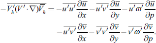
In the previous section, we found that the diurnal signals of precipitation propagating from Sumatra reach the open ocean. We now consider upscale effects of the strong diurnal cycle on synoptic disturbances over the eastern Indian Ocean. The activity of synoptic disturbances is represented by the eddy kinetic energy (K′)
 |

The composites for (left) K′ (m2 s−2) and (right) tendency of K′ (dK′/dt) (10−5 m2 s−3) at 850 hPa for the strong diurnal events. Dotted areas represent more than the 95 % confidence level. The numbers on the top right sides show lags in days from the reference day (i.e., day 0).

Composite eddy relative vorticity at 850 hPa (10−5 s−1) averaged from days 0 to +2 for the strong diurnal events. Dotted areas represent more than the 95 % confidence level. Red (blue) shading in the northern (southern) hemisphere represents cyclonic eddies.

Time-longitude sections of the composite dK′/dt at 850 hPa (10−5 m2 s−3) for (left) the strong and (right) weak diurnal events averaged for (upper) 3–13°N and (lower) 3–13°S. Gray contours indicate more than the 95 % confidence level.
To elucidate the impact of the diurnal cycle, the same composites but for the weak diurnal events are shown in the right panel of Fig. 8. The strong K′ generation off Sumatra found in the strong events is not observed in the weak events; instead, a K′ decrease dominates over the eastern Indian Ocean from day −4. Differences of dK′/dt between the strong and weak diurnal events (Fig. 9) are statistically significant, especially over the eastern Indian Ocean from day 0, and large values shift westward as time proceeds, corresponding to the K′ increase during the strong diurnal events. Given the diurnal offshore migration of precipitation reaching 500 km off the coast (Fig. 5), these differences between the strong and weak diurnal events indicate that the enhancement of synoptic disturbances off Sumatra is connected to the diurnal cycle of precipitation over Sumatra.
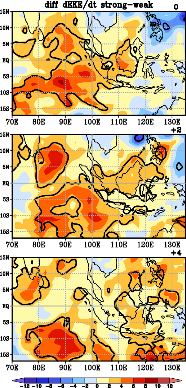
Differences of the composite dK′/dt at 850 hPa between the strong and weak diurnal events. Positive values represent larger dK′/dt for the strong diurnal events. Contours indicate more than the 95 % confidence level using the twosample Student's t test.
As mentioned in the Introduction, the MJO can act to modulate the diurnal cycle over the MC. The diurnal events detected in the previous sections might depend on the MJO phases. Figure 10 (left) shows the accumulated days of the diurnal events in each MJO phase. Strong diurnal events occur preferentially in MJO phases 2 and 3 when the active MJO convection is located over the Indian Ocean, consistent with previous studies (e.g., Fujita et al. 2011; Peatman et al. 2014). In addition, numerous the diurnal events are found when the MJO is inactive (Non-MJO). During phase 1, there are many days when the MJO amplitude exceeds 1.0 (black bars), but most of them did not last for 15 days, resulting in a smaller number of the MJO events (gray bars) than those during phases 2 and 3. The diurnal events decrease in phase 4 when the MJO convection lies over the MC, which might be related to the weakening of solar radiation by a large amount of clouds. In comparison to the climatology (Fig. 10, right), drastic reductions during phases 4–8 when the MJO is located over the MC or the Pacific stand out.

(Left) Accumulated days for the strong diurnal events in each MJO phase. Black bars indicate the days when the MJO amplitude exceeds 1.0, and gray bars represent the days during the MJO events defined in this study when the MJO amplitude exceeds 1.0 for 15 consecutive days. The “Non” refers to the MJO inactive days (see Section 2); (right) the total number of days for each MJO phase when the MJO amplitude exceeds 1.0 during the rainy season.
One concern arising from the strong dependence of the diurnal cycle on the MJO phases is that the active synoptic disturbances during the strong diurnal events shown in Figs. 6, 7, and 8 (left) include internal synoptic eddies within the MJO convective envelope over the Indian Ocean and may not be triggered solely by the diurnal cycle over Sumatra. Therefore, we classify the diurnal events into three groups according to the MJO amplitude and phases (see Section 2 for the MJO definition). The diurnal events when the MJO phases are from 2 to 3 (from 5 to 7) are classified into the MJO-IO (MJO-Pac). The other group is composed of the events when the MJO is inactive (Non-MJO). The numbers of the strong diurnal events during the MJO-IO, MJO-Pac, and Non-MJO are 36, 5, and 20, respectively. The contrast in the number between MJO-IO and MJO-Pac is consistent with the strong dependence of the diurnal cycle on the MJO phase, as shown in Fig. 10. Hereafter, composite results for the MJO-IO and Non-MJO are shown as a large part of the composite results for the MJO-Pac is not statistically significant owing to its few degrees of freedom. This classification is intended to investigate the impact on synoptic disturbances solely by the diurnal signals over Sumatra during the Non-MJO and the interaction between MJO and the diurnal signals through synoptic disturbances during the MJO-IO. A comparison of the generation rates of K′ between the MJO-IO and Non-MJO is shown in Figs. 11 and 12. The thick black lines represent the proxy for the intraseasonal convective envelope. During the Non-MJO (Fig. 11, right), the K′ is first generated south of the equator on day 0 and spreads both north and south of the equator over several days. Although strong K′ generation is found across the equator off Sumatra, its westward and/or poleward migrations are unclear (Fig. 12, right). In the MJO-IO (Figs. 11, 12, left), on the other hand, twin disturbances straddling the equator develop off Sumatra and migrate poleward and/or westward rapidly from day 0, resulting in negative values around the equator. These apparent twin synoptic disturbances straddling the equator during the MJO-IO imply the enhancement of the Rossby wave response within the MJO. In addition to the westward migration found from days 0 to +4 off Sumatra, the large-scale K′ generation propagates eastward from the central Indian Ocean to the western Pacific (Fig. 12, left), corresponding to the large-scale intraseasonal convection across the MC shown by black lines. The influence of the diurnal cycle on the eastward-propagation of the MJO is discussed in Section 7.

The composite dK′/dt at 850 hPa (10−5 m2 s−3) for the strong diurnal events during (left) the MJO-IO and (right) Non-MJO. Dotted areas represent more than the 95 % confidence level. The thick black lines show 20–100 days bandpass-filtered OLR of −20 W m−2. The numbers on the top right sides show lags in days from the reference day (i.e., day 0).

Same as in Fig. 8, except for the strong diurnal events during (left) the MJO-IO and (right) Non-MJO. The thick black lines show negative values of 20–100 days bandpass-filtered OLR with intervals of 5.0 W m−2.
We also check the dependence of the composites based on the weak diurnal events on the MJO phases (not shown). The numbers of the weak diurnal events during the MJO-IO, MJO-Pac, and Non-MJO are 2, 35, and 10, respectively. Compared to the strong events, the percentage of the events during the MJO-Pac (MJO-IO) increases (decreases) drastically, implying that the existence of the MJO over the Pacific has great influence on weakening the diurnal events over the MC through a large-scale descending branch of the MJO. As shown in composite dK′/dt for all weak diurnal events in Fig. 8 (right), a K′ decrease is dominant over the eastern Indian Ocean for the Non-MJO and MJO-Pac. Composite results during the MJO-IO are not statistically significant owing to its very few samples.
To understand the mechanisms of K′ generation shown in the previous sections, we consider the budget for K′ in the form used in Seiki and Takayabu (2007) and Seiki et al. (2018)
 |

Composite vertical structures of each term (10−5 m2 s−3) in (a) the eddy kinetic energy budget and (b) Student's t statistics from 1000 to 150 hPa for all the strong diurnal events on day 0 averaged over the southeastern Indian Ocean (1.25–6.25°S, 92.5–102.5°E). The dark gray line in (b) indicates the 95 % confidence level.
We focus on the two dominant energy sources, KmKe in the lower troposphere at 850 hPa and PeKe in the upper troposphere at 250 hPa, to compare the composite for the MJO-IO with that for the Non-MJO (Fig. 14). In the MJO-IO, strong K′ generation by KmKe is found broadly in the southern Indian Ocean (Fig. 14a), with the highest value found in the central part. Additionally, a secondary peak of KmKe is apparent south of the equator off Sumatra. High KmKe values are also found in the northern Indian Ocean around 5°N and east of the Malay Peninsula in the South China Sea. Similar horizontal patterns are also found in the Non-MJO (Fig. 14b), but the maximum in the northern Indian Ocean shifts northeastward, lying north of Sumatra. These distributions of high KmKe generally correspond to the dK′/dt maximum shown in Fig. 11. The KmKe can be decomposed into six terms
 |

(a, b) The composite KmKe at 850 hPa (10−5 m2 s−3) and (c, d) PeKe at 250 hPa (10−5 m2 s−3) for the strong diurnal events during (a, c) the MJO-IO and (b, d) Non-MJO on day 0. Dotted areas represent more than the 95 % confidence level.
The dominant contributors to KmKe over the Indian Ocean are the first and second terms on the right hand side (Figs. 15a, b, g, h), which represent the barotropic wave accumulation through the mean zonal wind convergence (e.g., Webster and Chang 1988; Sobel and Bretherton 1999) and energy conversion through the meridional shear of the mean zonal winds, respectively. Both terms are associated with a horizontal distribution of the mean zonal winds. The −u′ u′͞ ∂u̅/∂x term (Figs. 15a, g) dominates the large KmKe values over the northeastern and central south Indian Oceans, corresponding to strong zonal convergence areas of the mean westerly winds (Figs. 16a, b). The highest KmKe values found in the southern Indian Ocean are explained as resulting from the −u′v′̅ ∂u̅/∂y term (Figs. 15b, h). The mean westerly winds around the equator changed drastically to the easterlies around 5°S in a north-south direction (Figs. 16a, b). This strong meridional shear of the mean zonal winds induces the large K′ generation around 5°S if seed disturbances exist. Over the South China Sea, the high KmKe values are attributed to the fifth term (Figs. 15e, k), −v′v′̅ ∂v̅/∂y, representing the wave accumulation through the mean meridional wind convergence, corresponding to the convergence areas of the mean northeasterly winds. However, this energy conversion is offset largely by the first term (Figs. 15a, g) to the east of 105°E, resulting in the KmKe maximum east of the Malay Peninsula.

Composites of each term composing KmKe at 850 hPa (10−5 m2 s−3) for the strong diurnal events during (a–f) the MJO-IO and (g–l) Non-MJO on day 0. Dotted areas represent more than the 95 % confidence level.
With respect to PeKe in the upper troposphere during the Non-MJO (Figs. 14d), PeKe has larger values in the southern Indian Ocean than in the northern Indian Ocean although the differences are statistically insignificant. PeKe values during the MJO-IO (Fig. 14c) are generally higher than those during the Non-MJO and statistically significant over broad areas, indicating that synoptic convective activities are high and robust. Higher values of PeKe are located straddling the equator over the eastern Indian Ocean, representing twin convective disturbances across the equator. As convective activities depend on SST, composite SST values for the MJO-IO and Non-MJO are plotted in Figs. 16c and 16d, respectively. Over the area west of Sumatra between 5°S and 5°N, SST is broadly high and partly exceeds 28°C, which is sufficient to facilitate active convection, in both composites. This indicates that the difference of PeKe between the two groups cannot be explained by the SST distribution. On the other hand, the horizontal convergence of near-surface winds might have a strong impact on convective activities. As widespread southeasterly winds in the southern Indian Ocean converge around 5°S, synoptic convection can develop easily when seed disturbances are provided by the offshore migration of convection from the western coast of Sumatra. In the northern Indian Ocean, mean northeasterly winds from the South China Sea are much stronger during the MJO-IO than those during the Non-MJO, corresponding to drastic SST cooling over the South China Sea. These strong northeasterlies and equatorial westerlies converge over the northeastern Indian Ocean around 5°N, resulting in the convective development during the MJO-IO.

(a, b) Composite mean zonal winds at 850 hPa (m s−1) and (c, d) SST (°C) for the strong diurnal events during (a, c) the MJO-IO and (b, d) Non-MJO on day 0. Dotted areas represent more than the 95 % confidence level. The vectors indicate the composite mean wind fields at (a, b) 850 hPa and (c, d) 1000 hPa, where either the zonal or the meridional component is significant at the 95 % level.
In summary, the eddy kinetic energy budget analysis shows that the K′ generation in the eastern Indian Ocean is apparent when the diurnal cycle over Sumatra is strong. This arises from the barotropic energy conversion from the mean kinetic energy (KmKe) and active synoptic convection (PeKe). The convergence of mean southeasterly winds around 5°S, which provides a favorable condition for the development of synoptic disturbances from the seed disturbances excited by the diurnal cycle, is observed in both the MJO-IO and Non-MJO. In contrast, clear differences between the two composites can be seen in the northern hemisphere. In the MJO-IO, strong northeasterly winds blowing into the organized MJO convection cause a horizontal convergence in the northeastern Indian Ocean and contribute to the development of the synoptic disturbance there, whereas such features are not observed in the Non-MJO. As a result, twin synoptic disturbances straddling the equator are observed only in the MJO-IO.
So far in this study, the development of synoptic disturbances over the eastern Indian Ocean is found when the diurnal cycle over Sumatra is strong. Especially when the MJO convection is located in the Indian Ocean (MJO-IO), the twin cyclonic disturbances straddling the equator develop, implying the enhancement of the Rossby wave response within the MJO. As the Rossby waves propagate westward, the enhancement of the Rossby wave response may weaken or stop the eastward-propagation of the MJO. This hypothesis is consistent with recent modeling studies indicating that the diurnal cycle tends to hinder the propagation of the MJO across the MC (Hagos et al. 2016; Majda and Yang 2016). From the aspect of moisture budget, on the other hand, the intensified Rossby wave response leads to anomalous drying of the equatorial lower troposphere to the west of the MJO convection through meridional advection, resulting in the facilitation of the eastward-propagation of the MJO (e.g., Maloney 2009). In this section, we discuss the influence of the diurnal cycle over Sumatra on the MJO propagation.
For this purpose, the MJO events (see the definition in Section 2) with active convection over the Indian Ocean (phase 2 and/or 3) during the rainy season are classified into two groups: 30 events in which strong diurnal events occur and 10 other events. The latter events consist of one MJO event in which weak diurnal events occur, and nine MJO events in which neither strong nor weak diurnal events occur. Note that one event in which both strong and weak diurnal events occur is excluded. Three-quarters of the MJO events occur with strong diurnal events, indicating that the strong diurnal cycle over Sumatra is favorable for the development of the MJO. Table 1 shows the statistics of the MJO events with the strong diurnal events and the others. It shows that the MJO with the strong diurnal cycle has longer duration (30.4 days) than the others (24.6 days), on average, but the first and last phases of the MJO are comparable. The average duration in each MJO phase (Table 2) indicates that phases 2, 3, and 5, corresponding to the MJO path over the Indian Ocean and the western Pacific, contribute to the longer duration of the MJO with the strong diurnal events. These statistics suggest that the strong diurnal cycle over Sumatra contributes to the longer duration of the MJO around the MC. To examine convective activities during the MJO events, time-longitude sections of composite OLR and intraseasonal OLR anomalies averaged for 10°S–10°N for the two MJO groups are shown in Fig. 17. Day 0 indicates the last day of phase 2 or the first day of the phase 3. The apparent and statistically-significant eastward propagation of intraseasonal convective anomalies across the MC is detected only for the MJO events with strong diurnal events (Fig. 17, left), whereas intraseasonal convective activities over the Indian Ocean are comparable. In addition, convective activities off the western coast of Sumatra are enhanced rapidly after day 0. For the other MJO events (Fig. 17, right), the intraseasonal convection weakens over the MC. These results indicate that the smooth propagation of the intraseasonal convective anomalies across the MC is accompanied by strong diurnal events. Interestingly, the intraseasonal convection for the other MJO events develops again over the western Pacific and its signal tends to propagate faster over the MC than that with the strong diurnal cycle, probably because of decoupling with convection over the MC.


Time-longitude sections of composite equatorial OLR (shading) and 20–100 days bandpass-filtered OLR (contours) averaged between 10°S and 10°N for (left) the MJO events with the strong diurnal events and (right) the other MJO events. All MJO events have phase 2 and/or 3. Solid (dashed) contours indicate negative (positive) values with intervals of 5.0 W m−2. Day 0 indicates the last day of phase 2 or the first day of phase 3. Dotted areas represent more than the 95 % confidence level of composite bandpass-filtered OLR.
It has been known that the behavior of the MJO is distinct between the boreal summer and winter. During the boreal summer, intraseasonal convection shows not only eastward but also northward propagation, called the boreal summer intraseasonal oscillation (BSISO; e.g., Wang and Rui 1990; Kikuchi et al. 2012; Kiladis et al. 2014). As this study focuses on the rainy season from September to April, the intraseasonal convection during September–November (SON) may have characteristics of a summer-type MJO compared to that during December–February (DJF). Therefore, we check the seasonal dependence of the MJO events (Table 3). Whereas the MJO events with strong diurnal events have weak seasonality, the other MJO events are observed frequently from March to April (MA). The composite OLR and intraseasonal OLR anomalies for the MJO events during SON, DJF, and MA (Fig. 18) show that the MJO convection with strong diurnal events during both SON and DJF (Figs. 18a, c) shows the smooth eastward propagation over the MC, although that over the western Pacific are somewhat stronger during DJF. For the other MJO events during SON (Fig. 18b), the eastward-propagating convection is suppressed substantially over the MC. These results are consistent with those of total composites (Fig. 17). During MA (Figs. 18d, e), on the other hand, convective activities for both the MJO events weaken over the MC and reactivated convection over the western Pacific is stronger for the other MJO events. These results indicate that the influence of the diurnal cycle on the MJO behavior is strong during both SON and DJF, but weak during MA. Small differences in the MJO behavior and its dependence on the diurnal events between SON and DJF imply that the difference of the MJO types, that is, the summer and winter types, does not affect the results of this study. The different relationship between the MJO and the diurnal cycle during MA is left for future work.
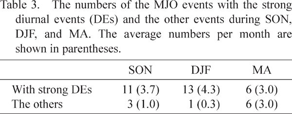

Same as in Fig. 17, except for the MJO events during (a, b) SON, (c) DJF, and (d, e) MA on day 0. Note that composites for the other MJO events during DJF are not shown owing to only one sample.
The results shown in this paper indicate statistical relationship between the diurnal cycle and the eastward propagation feature of the MJO. However, further studies are needed to clarify the physical mechanism of how the diurnal cycle and associated synoptic disturbances over the eastern Indian Ocean affect the MJO propagation, which remains for our future study. The sensitivity experiment using numerical models with and without diurnal forcing may be one of the promising approaches. In particular, our results indicate that the diurnal cycle only during MJO phases 2 and 3 affects the subsequent behavior of the MJO. Therefore, it seems interesting to enhance or suppress diurnal forcing in particular MJO phases, in addition to doing so over the whole simulation period irrespective of the phases as done in previous studies such as Hagos et al. (2016).
In this study, we examine the impact of the diurnal cycle of precipitation over and around Sumatra Island on synoptic disturbances over the eastern Indian Ocean and its relationship with the MJO phases and amplitude. A sequence of days when the diurnal cycle of precipitation over the Sumatra area is strong (weak) is defined as a strong (weak) diurnal event. Much higher precipitation amounts around the western coast of Sumatra are confirmed during the strong diurnal events, indicating that the strong diurnal cycle provides large condensation heating. The strong diurnal events are found most frequently in October and November, generally corresponding to the peak rainy season (e.g., Hamada et al. 2002). In addition to the seasonal dependence, the strong diurnal events occur preferentially during MJO phases 2 and 3 when the MJO convection lies over the Indian Ocean, consistent with previous analysis (e.g., Fujita et al. 2011; Peatman et al. 2014). We also confirm the nighttime offshore migration of precipitation (e.g., Mori et al. 2004) reaching 500 km off the coast, located in the open ocean, when the strong diurnal events occur.
Although the modulation of the diurnal cycle by the MJO has been studied intensively in recent years (e.g., Tian et al. 2006; Ichikawa and Yasunari 2007; Rauniyar and Walsh 2011; Fujita et al. 2011; Peatman et al. 2014), the upscale effects of the diurnal cycle on synoptic and intraseasonal disturbances remain elusive. Therefore, we examine the activities of synoptic disturbances over the eastern Indian Ocean by the eddy kinetic energy budget analysis based on the diurnal events considering the MJO phases and amplitude. The K′ generation in the southeastern Indian Ocean is apparent when the diurnal cycle over Sumatra is strong regardless of the MJO phases and amplitude. It is related to the development of synoptic disturbances from the seed disturbances arising from the diurnal cycle by virtue of the favorable mean state such as the convergence of mean southeasterly winds around 5°S. In contrast, synoptic disturbances in the northern Indian Ocean off Sumatra develop only in the MJO-IO, which can result from the convergence of the mean equatorial westerly winds over the Indian Ocean and the mean northeasterly winds from the South China Sea blowing into the convective center of the MJO in the Indian Ocean. Note that the intensified northeasterly winds are probably associated with strong cold surges over the South China Sea that are known to be observed frequently when the MJO convection is located over the Indian Ocean or the MC (Jeong et al. 2005; Chang et al. 2005). As a result, the twin disturbances straddle the equator and migrate poleward and/or westward rapidly only during the MJO-IO, suggesting that the Rossby wave response within the MJO is intensified. In the Non-MJO, on the other hand, the synoptic disturbances develop mainly over the southern Indian Ocean and do not migrate in any direction. This indicates that although the strong diurnal cycle over Sumatra triggers the synoptic disturbances over the eastern Indian Ocean regardless of the MJO phase and existence, the twin cyclonic disturbances across the equator can develop only when the MJO convection is located over the Indian Ocean. When the diurnal cycle is weak over Sumatra, the K′ decrease is found over the eastern Indian Ocean, showing the suppression of the synoptic disturbances.
To examine the impact of the diurnal cycle on the MJO behavior, a comparison of the MJO events having phase 2 and/or 3 with the strong diurnal events with such MJO events but without the strong diurnal events is presented. The MJO events with the strong diurnal events tend to have longer duration and stronger convective activities around the MC than the other MJO events, indicating that the strong diurnal cycle of precipitation over Sumatra facilitates the smooth propagation of the intraseasonal convection across the MC. For the MJO events without the strong diurnal events, whereas the intraseasonal convective anomalies weaken over the MC, the overall MJO signals tend to propagate across the MC faster than the MJO events with the strong diurnal events, and the intraseasonal convection strengthens again over the western Pacific. Note that the MJO propagation speed may be important for forecasting when teleconnection patterns are excited by the MJO convection over the western Pacific, which cause significant impacts even in the mid-latitudes (e.g., Zhang 2013).
Although an averaged MJO event has been known to propagate eastward with a mean speed of ∼ 5 m s−1 over the Ind-Pacific warm pool (e.g., Zhang 2005), the behavior of individual MJO events such as the amplitude and propagation speed differs considerably from event to event (e.g., Kerns and Chen 2016; Wang et al. 2019). The presence or absence of the strong diurnal events focused on in this study may play a role in understanding the MJO diversity. In addition, only one MJO index (the RMM index) is used to identify the MJO events and to determine its amplitude and phases in this study. The statistics of the MJO events in Tables 1–3 may have sensitivity to the MJO indices (Kiladis et al. 2014).
In this study, strong and weak diurnal events are identified first. The factors determining the amplitude of the diurnal cycle remain unclear. The diurnal cycle in the tropics is driven primarily by insolation. However, the number of strong diurnal events in the equinox months (September and March) is smaller than that in October and November (Fig. 2). The favorable MJO phases for the diurnal cycle (phases 2 and 3) correspond to the convective suppressed condition over the MC, linked to high insolation (Fig. 10 and previous studies). However, the suppressed phases are also observed in the rear side of the MJO convection (i.e., phases 6 and 7). Another factor, such as the moisture condition, may influence the diurnal cycle of precipitation. From a large-scale viewpoint, ENSO might be the factor. The strong diurnal events identified in this study are classified into El Niño (2002, 2004, 2006, and 2009), La Niña (2000, 2005, 2007, 2008, 2010, and 2011), and neutral years (2001, 2003, 2012, and 2013), based on the ENSO index derived by the NOAA. There are no clear differences among the numbers of strong diurnal events per year during the El Niño (9), La Niña (13), and neutral years (10). This is consistent with previous studies (e.g., Rauniyar and Walsh 2013), indicating that the dependence of the strength of the diurnal cycle on ENSO has regional differences owing to topography. Multiple factors influence the strength of the diurnal cycle, such as insolation, moisture condition, topography, and others. Further studies are needed to detect all these factors and estimate their contribution rate.
Our results show the impact of the strong diurnal events over Sumatra on the development of the synoptic disturbances over the eastern Indian Ocean. However, the importance of diurnal fluctuations or the migration of precipitation still remains unclear. The composite analysis based on the strong diurnal cycle of precipitation over Sumatra also shows a high amount of daily-mean precipitation simultaneously. Therefore, it is uncertain whether diurnal or sustained heat release by precipitation off the coast has a large effect on triggering synoptic disturbances over the Indian Ocean, which are possibly linked to the MJO propagation. To clarify the aforementioned question, we might have to focus on mesoscale convective systems to understand how diurnal convection near the coast leads to synoptic disturbances in the open ocean. However, the time and horizontal resolutions of the reanalysis data are too coarse, and the intensive observations have covered a limited area. Sensitivity experiments using numerical models might be useful, but there are few models that can reproduce multiscale phenomena including the diurnal offshore migration, synoptic disturbances, and the MJO. Recently, the global cloud resolving models have been developed internationally. For example, Miura et al. (2007) have simulated the MJO successfully using the global cloud-resolving Nonhydrostatic ICosahedral Atmospheric Model (NICAM; Tomita and Satoh 2004). The analysis focusing on the offshore regions using these high-resolution cloud resolving models might be useful for future studies.
The authors would like to thank Kunio Yoneyama for helpful discussions. Comments from two anonymous reviewers also improved the original manuscript. This study was partly supported by Grants-in-Aid for Scientific Research (18H05879 and 20H02252) of the Japan Society for the Promotion of Science.