巻号一覧
123 巻 (2014)
- 6 号 p. 789-
- 5 号 p. 643-
- 4 号 p. 389-
- 3 号 p. 323-
- 2 号 p. 159-
- 1 号 p. 1-
123 巻, 5 号
選択された号の論文の11件中1~11を表示しています
- |<
- <
- 1
- >
- >|
表紙
-
2014 年 123 巻 5 号 p. Cover05_01-Cover05_02
発行日: 2014/10/25
公開日: 2014/11/13
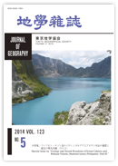
ジャーナル フリーフィリピン・ルソン島のピナツボ火山(標高 1486 m)は,マニラ首都圏から北西約 90 kmにあり,山頂部のクレーター(直径約 2.5 km)は,1991年6月15日の破局的な火砕流噴火によって出現した.現在は,北側斜面を流れるオドネル川に沿って山頂まで日帰りで行くことができる.写真は,そのルートの終点であるクレーター北縁から2006年4月に撮影したもので,左側の崖の背後にも湖は広がる.クレーター形成直後,内部に溶岩ドームが形成されたが,現在は湖水面下に没している.湖水は印象的なコバルトブルーであり,湖岸や湖底で温泉が湧出している.奥に見える岩体は,噴火前からあった溶岩ドームの残骸で,著しい破砕構造がみられる.手前の湖岸には人が写っている.これは,ガイドとともに訪れたツアー客であり,美しいクレーターレークを楽しんでいる.
(写真と説明:奥野 充・小林哲夫)抄録全体を表示PDF形式でダウンロード (1038K)
論説
-
山内 一彦, 白石 健一郎, 檀原 徹2014 年 123 巻 5 号 p. 643-670
発行日: 2014/10/25
公開日: 2014/11/13
ジャーナル フリーThis paper examines changes to the river system and faulting in the Ikachi Basin and surrounding area in the southwestern part of the Chugoku Mountains since the Middle Pleistocene, based of an investigation of the fluvial terrace and tectonic landforms. Fluvial terrace surfaces in the study area are classified into five levels: H, M1, M2, L1, and L2, in descending order. The M1 terrace surface is widely observed in the Ikachi Basin, and there is a narrow band of Sanbe-Kisuki tephra on the top layer of the terrace deposit, suggesting that the surface was formed around 110-115 ka. Aira-Tn tephra is observed in the L2 terrace deposit, indicating that it was formed around 30 ka. The distribution of terrace and deposit indicates the existence of the Paleo-Shiwari River, which differed from the river system existing today. The Paleo-Shiwari River flowed northwestward from the southeastern margin of the Ikachi Basin, and from near Hizumi, westward through the basin. There is a possibility that the upper reaches of the Paleo-Shiwari River reached Yashiro Island. The Paleo-Shiwari River lost its upper reaches as a result of river capture around the current Obatake-Seto in Middle Pleistocene. Furthermore, as a result of continued large-scale uplifting in the downstream area of the Paleo-Shiwari River basin, accompanied by activities of the Hizumi and Oguni faults since the Middle Pleistocene, the height of the riverbed of the Paleo-Shiwari River increased and its riverbed slope became gentle. At the same time, continued large-scale subsidence with faulting from the downstream basin of the Yuu River to Aki-Nada led to a gradual steepening of the riverbed of the Yuu River, and the valley head of the Yuu River along the fracture zone expanded due to erosion. Subsequently, the Paleo-Shiwari River was captured by the Yuu River at the Hizumi depression around 110-115 ka during the formation period of the M1 surface. It is concluded that river capture between the Yuu River and the Shiwari River occurred due to the influence of crustal movements.抄録全体を表示PDF形式でダウンロード (5218K) -
石村 大輔, 山田 圭太郎, 宮内 崇裕, 早瀬 亮介2014 年 123 巻 5 号 p. 671-697
発行日: 2014/10/25
公開日: 2014/11/13
ジャーナル フリーTephras interbedded with Holocene sediments in coastal lowlands along the Sanriku Coast, northeast Japan are described, and well-known widespread and local tephras are correlated based on morphology, refractive index, and chemical composition of volcanic glass shards, stratigraphy, and radiocarbon age. As a result, tephras that are correlated with Towada-a (To-a), Towada-Chuseri (To-Cu), Kikai-Akahoya (K-Ah), Oguni pumice, Towada-Nambu (To-Nb), and Hijiori-Obanazawa (Hj-O) are identified. In particular, To-Cu is distributed throughout the study area and is recognized to be a useful key tephra. In addition, To-a and Oguni pumice were discovered for the first time on the Sanriku Coast. The results suggest that the morphologies and the refractive indexes of volcanic glasses are useful and important for distinguishing tephras and correlating with widespread and local tephras on the Sanriku Coast.抄録全体を表示PDF形式でダウンロード (3220K) -
石村 大輔2014 年 123 巻 5 号 p. 698-720
発行日: 2014/10/25
公開日: 2014/11/13
ジャーナル フリーThe process of terrace formation in Japan is discussed in the context of advances in tephrochronology. In particular, the ages of fluvial and marine terraces correlate with climate and glacio-eustatic sea-level changes. However, previous studies do not distinguish between the influences of climate changes and base-level changes (glacio-eustatic sea-level changes) for terrace formations, and mainly target northeast Japan due to advantages related to tephrochronology and terrace development. Therefore, this study focuses on the Ohmi Basin, Shiga Prefecture, southwest Japan, to reveal the process of terrace formation under conditions with no base-level changes, and compares them to those in northeast Japan. To achieve this aim, a drilling survey at terrace surfaces and a cryptotephra analysis are conducted. Widespread tephras, Kikai-Akahoya (K-Ah) tephra, Aira-Tn (AT) tephra, and Kikai-Tozurahara (K-Tz) tephra, are used to correlate fluvial terraces and establish the chronology of fluvial terraces in the eastern and western parts (Koto and Takashima regions, respectively) of the Ohmi Basin. Terrace correlation shows that terraces formed during Marine Isotope Stage (MIS) 2 are distributed in both regions under different tectonic settings. This indicates that climate change is the main factor of terrace formation in the Ohmi Basin. Therefore, river conditions during MIS 1, 2, and 5 are compared, and influences of climate changes and crustal movements for terrace formation are estimated. As a result, terrace formation in the Takashima region is explained by climate changes and fault movements. On the other hand, terrace formation in the Koto region is explained by climate changes and tectonic tilting. Consequently, these results suggest that the fluvial terraces in the Ohmi Basin are climatic terraces and that older to younger terrace steps could be the result of a combination of climate changes and crustal movements without base-level changes.抄録全体を表示PDF形式でダウンロード (7803K)
短報
-
―微小変位地形と地下構造探査結果の整合性―水本 匡起, 吾妻 崇, 堤 浩之, 後藤 秀昭, 田力 正好, 中田 高, 松田 時彦2014 年 123 巻 5 号 p. 721-732
発行日: 2014/10/25
公開日: 2014/11/13
ジャーナル フリーSmall-scale tectonic landforms are identified from detailed aerial photograph interpretations, in order to clarify evidence of faulting since the late Pleistocene period along the marginal fault zone at the western foot of the Suzuka Mountains, central Japan. Surface fault traces at least 9-km long are recognized in the central part of this fault zone. Along the Uso River, small tectonic scarps are recognized on young fan terraces where assumed faults were identified previously by seismic reflection profiling. These scarps suggest that the most recent movement at the fault occurred during or after the late Pleistocene period. Progressive vertical displacement is recognized in the subsurface structure of Kobiwako Group, indicating that the fault zone has been active since the Plio-Pleistocene period. This fault may extend further to the north and south in the western foot area of the Suzuka Mountains.抄録全体を表示PDF形式でダウンロード (6516K)
小特集「フィリピン・ルソン島のイロシンカルデラとブルサン火山の地質と最近の噴火活動(その2)」
-
奥野 充, レナート ソリデュム ジュニア, マリア ハナ ミラブエノ, クリストファー ニューホール, 下司 信夫, 須貝 俊彦, 田中 ...2014 年 123 巻 5 号 p. 733-738
発行日: 2014/10/25
公開日: 2014/11/13
ジャーナル フリーブルサン火山複合体(BVC)を構成するイロシンカルデラとブルサン火山は,フィリピン共和国のルソン島南東端に位置する。この論文は,小特集「フィリピン・ルソン島のイロシンカルデラとブルサン火山の地質と最近の噴火活動」(その1)と(その2)に掲載された論文について,その概要を述べたものである。Moriya(2014)は,フィリピン諸島の84火山の地形発達史を予察的にまとめており,フィリピンの火山の概要を理解することができる。Kobayashi et al. (2014a, b)は,カルデラ形成噴火の推移を明らかにしており,Kobayashi(2014)では,姶良カルデラと比較して両者の共通性を明確にしている。Danhara et al. (2014)は,イロシン火砕流および関連する堆積物の岩石記載的特徴を報告している。Komazawa et al. (2014)は,カルデラ壁に対応する急勾配が地下にも存在することをブーゲー異常図から示している。Takashima and Kobayashi (2014)は,イロシン火砕流とそれに伴う降下火山灰(co-ignimbrite ash-falls)について,36±8 ka, 38±10 ka, 33±8 ka, 45±10 kaの熱ルミネッセンス年代を報告している。Mirabueno et al. (2014)は,カルデラ内のボーリングコア試料から火砕流堆積物1層と降下テフラ12層をみいだしている。Kinoshita and Laguerta (2014)は,ブルサン火山やマヨン火山で実施されている噴煙映像観測の方法・結果を紹介している。Delos Reyes et al. (2014)は,ブルサン火山2006-2007年噴火による降下テフラの分布と岩石記載的特徴を報告している。Taguchi et al. (2014a)は,ブルサン火山周辺の温泉と冷泉を紹介している。抄録全体を表示PDF形式でダウンロード (333K)
総説
-
小林 哲夫2014 年 123 巻 5 号 p. 739-750
発行日: 2014/10/25
公開日: 2014/11/13
ジャーナル フリーThe eruption sequences of two caldera volcanoes, Aira in Japan and Irosin in the Philippines, were examined, and an eruption sequence for caldera volcanoes is constructed as follows: first, eruptions of felsic magma as a precursory event; second, a plinian eruption associated with intra-plinian flows followed; third, a fine-grained ignimbrite eruption occurred, which is followed by a catastrophic caldera-forming eruption; fourth, voluminous co-ignimbrite ash was generated and dispersed over a wide area; and, finally, post-caldera volcanoes were formed. In addition, intense earthquakes occurred either at the late stage of the plinian phase of the Irosin caldera or shortly before the final caldera-forming eruption of the Aira caldera. A similar eruption sequence was observed for the 7.3 cal ka BP caldera-forming eruption at Kikai caldera in Japan. Therefore, the eruption sequences observed at caldera volcanoes in Japan and the Philippines are considered to form the most fundamental processes of a caldera-forming eruption.抄録全体を表示PDF形式でダウンロード (2060K)
短報
-
マリア ハナ ミラブエノ, 鳥井 真之, エドアルド ラグエルタ, パーラ デロス レイス, 藤木 利之, エリクソ バリソ, 奥野 充, ...2014 年 123 巻 5 号 p. 751-760
発行日: 2014/10/25
公開日: 2014/11/13
ジャーナル フリーフィリピン,南ルソンのイロシンカルデラ内の地点IrBH-2で深度 50 mまでコア試料を採取し,50 cmごとに堆積物を記載した。深度 7.02~10.40 mから採取した植物片について,およそ1000~1800BPのAMS放射性炭素年代を得た。このコア試料では,ラハールや河川堆積物が多くを占めるが,上部 12 mは主として安山岩質の河川堆積物からなり,ラハール堆積物をわずかに伴う。この層準は,おそらく安山岩質の後カルデラ火山活動に対比できると考えられる。深度 12~50 mまでに12枚の降下テフラと1枚の火砕流堆積物が認められるが,そのなかの5枚の降下テフラは再堆積かもしれない。火山ガラスと斑晶鉱物の屈折率を測定したいくつかの試料は,後カルデラ火山の活動では安山岩質~デイサイト質噴出物が主であり,流紋岩質なものがわずかに伴うことを示唆する。また,流紋岩質降下テフラは,41 cal kBPのイロシン火砕流堆積物と共通した岩石記載的特徴を持ち,両者が同一のマグマに由来する可能性を示唆する。抄録全体を表示PDF形式でダウンロード (2612K)
論説
-
パーラ デロス レイス, マリア アントニア ボルナス, マリア カーメンシア アルパ, エドアルド ラグエルタ, マベリン カフロガン, ...2014 年 123 巻 5 号 p. 761-775
発行日: 2014/10/25
公開日: 2014/11/13
ジャーナル フリールソン島南部のブルサン火山では,2006年に19回,2007年に7回の水蒸気噴火が発生した。それらの噴火によるテフラは,山頂火口の上空で西または南西方向に吹く卓越風に運ばれ,ソルソゴン半島の西部地域を覆った。いくつかのイベントでは,爆発地震が記録された。降下テフラの分布調査と試料採取ができた場合に,それらの噴出量の推計と構成物質の検討を行った。それぞれの降下テフラの体積は,得られた分布図から,およそ105 m3 の規模と推定された。火山灰の岩石記載的観察や蛍光X線分析では本質物質は検出されず,すべて水蒸気噴火によるものと結論づけられた。抄録全体を表示PDF形式でダウンロード (710K)
短報
-
木下 紀正, エドアルド ラグエルタ2014 年 123 巻 5 号 p. 776-788
発行日: 2014/10/25
公開日: 2014/11/13
ジャーナル フリーフィリピンのブルサン火山とマヨン火山について,噴煙映像観測の方法・結果と展望について述べた。マヨン火山では,ビデオカメラとネットワークカメラを用いて長時間の間歇自動観測を行っている。そこでは普通の可視光観測とともに,近赤外光やナイトショトモードも用いている。2003年6月の観測開始以来の日常的な活動はほとんど連続的な白煙放出であった。2006年7~8月と2009年12月の溶岩流出を伴う爆発的噴火の昼夜の記録が得られた。とくに夜間の溶岩流出・落下や,その数か月前に山頂火口に見られた高温溶岩の夜間検出に近赤外光やナイトショトモードは非常に有効であった。ブルサン火山では,滑らかな間歇撮影のできるデジタル高画質ビデオカメラによる観測を2010年11月に開始し,火口から 23 km離れた定点観測で2010年11~12月の活発な噴煙活動の記録が得られた。抄録全体を表示PDF形式でダウンロード (1362K)
口絵
-
田口 幸洋, ラミル レライ バクイラ, エドアルド ラグエルタ, マリア アントニア ボルナス, レナート ソリデュム ジュニア, パーラ ...2014 年 123 巻 5 号 p. xiii-xiv
発行日: 2014/10/25
公開日: 2014/11/13
ジャーナル フリーPDF形式でダウンロード (1407K)
- |<
- <
- 1
- >
- >|