Report
Regional scale rifting and subsidence in the vicinity of Iheya-Minor Ridge, the middle Okinawa Trough: Cruise results of KM17-12C
2018 Volume 27 Pages 68-76
Details
2018 Volume 27 Pages 68-76
Shallow sub-seafloor structure in the vicinity of Iheya-Minor Ridge was acquired using Sub-Bottom Profiler equipped on R/V Kaimei in KM17-12C cruise. Normal faults and downward warping stratification indicate regional subsidence of the studied area. The profiles also suggest local-scale compression folds that may associate with the intrusive volcanism of the ridge.
Iheya-Minor Ridge is a linear-shaped topographic high inside the Iheya Graben in the middle Okinawa Trough (Fig.1). The ridge and its vicinity have been the area of interest from the early days of the discoveries of the hydrothermal activity around Japanese Islands (e.g. Kimura et al., 1987).

Morphology around Iheya-Minor Ridge. The area magnified is indicated as a red-colored frame in inset.
Regardless of accumulation of bioenvironmental information in the area, few researchers have addressed its geology or tectonic conditions of the ridge; furthermore, most of the articles were published in 1990s (e.g. Ishibashi et al., 2015 and references therein). Especially, there are few seismic reflection profiles in direction perpendicular to the ridge, some of which are in low resolution mainly due to acquired equipment and conditions (e.g. Ikegami et al., 2015).
A comprehensive survey cruise focused on both bioenvironment and geology, under the umbrella of “Zipangu in the Ocean” project, one theme of the Cross-ministerial Strategic Innovation Promotion Programs (SIP) in November 2017 by R/V Kaimei. In the cruise, a standard set of surface geophysical survey, high resolution bathymetry, geomagnetic and gravity field observations, coupled both with ROV and with AUV dives were carried out in order to investigate regional tectonic conditions in the studied area. Within these, here we report the shallow sub-seafloor structure obtained by Sub-Bottom Profiler observation.
In the vicinity of Iheya-Minor Ridge, shallow sub-seafloor structure was surveyed by using Sub-Bottom Profiler both in directions perpendicular and parallel to the ridge. R/V Kaimei is equipped a parametric Sub-Bottom Profiler (TOPAS PS18, Kongsberg Inc.), of which secondary beam frequency and width is 0.5–6 kHz, 4.5°, respectively. Survey lines are shown in Fig.2. Vessel speed for ridge-parallel and ridge-perpendicular track is respective 6 kt and 8 kt according to the sea state. A ping interval was adjusted to the water depth; 1.37 sec for ridge-parallel direction and 1.50 sec for ridge-perpendicular direction, respectively in the studied area. Hereafter, a velocity of 1500 m/s has been used to convert from time to depth. The selected two magnified profiles were also shown in Fig.3.

A shaded relief map of the investigated area, based on multibeam echosounder: data obtained in MR13-E02 Leg1 Cruise (Chief Scientist: T. Kasaya). Red lines indicate the track lines of Sub-Bottom Profiler carried out during KM17-12C cruise. Contours shallower than 1500 m were not drawn. Topographic and morphological features are also indicated; dotted broken line: wrinkled morphology area; dotted line: folding exposed on the seafloor; solid arrows: reverse faults; open arrow: normal fault.

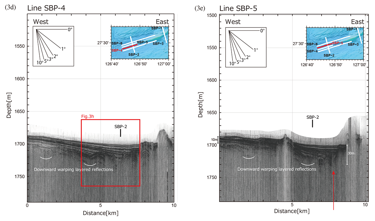
Sub-bottom profiler reflection cross-sections, positions of surveyed track is also shown in inset. (a) SBP-1, (b) SBP-2, (c) SBP-3, (d) SBP-4, (e) SBP-5, (f) SBP-6, (g) magnified cross-section for SBP-2 ranging from 2.5 to 6.5 km from the southern end of the track and (h) magnified cross-section for SBP-4 ranging from 3.7 to 7.7 km from the western end of the track; respective magnified positions are shown as red boxes on panel (b) and (d).

(Continued)
(Continued)

(Continued)

(Continued)

(Continued)
Well layered sedimentation approximately 30 m in thickness below seafloor was widely recorded in the area of western survey line, SBP-2. Clear folding structures reaching to the seafloor were found on the slopes both in the northern and southern part of the line. On the other hand, middle part of the line, downward warping reflections partly disturbed by dome shape structure, possibly intrusions, were observed from 3 to 6 km range from the southern end of the line. It reached a thickness of 35 m at the 3.5 km point from the southern end, where the trough basin reaches almost the same depth to the flat bottom of the trough. Further, a few normal faults with gentle dipping approx. 5–10° were found on the record, e.g. at the ~3.8 km point from the southern end of the track (Fig.3g). These features strongly suggest that the subsidence of the Iheya Graben. On the contrary to the above described rather regional feature, at least two reverse faults with several meters displacement were found at the 7 and 7.5 km points on the track (Fig.3b).
The profile on the southern side of Iheya-Minor Ridge (SBP-1) shows an irregular sea-bottom with hyperbolic reflections (Fig.3a). Due to the poor quality of the record, little sedimentation structure was recognized. Hyperbolic reflections along SBP-1may be formed by scattering from hydrothermal mounds on the southward slope of the ridge reported by JOGMEC (JOGMEC, 2014). An AUV survey in YK14-17 cruise of JAMSTEC also revealed that there are abundant hydrothermal mounds of which altitude exceeds 20 m (Miyazaki et al., 2015; Nakamura et al., 2015). Away from the mound-concentrated area, light colored soft and fine sediment covers the flat seafloor (Miyazaki et al., 2015). Even under such severe conditions for the observation, a few meters skin on the top of the reflection profile was recognized both in northern and southern part of the line. The strong reflection just beneath the skin indicates relatively young lava flow, which was obtained as mafic lava fragments by drilling of D/V Chikyu (Yamasaki et al., 2016). Age of this reflector is discussed later (subsection 3.2).
2.2 Ridge-Parallel ProfilesMultiply layered sedimentation down to 50 m below seafloor, thickening toward the ridge, was recorded clearly along the ridge-parallel lines (Fig.3c-e) except for the northernmost one, SBP-6 (Fig.3f). Beneath the SBP-6 line, rather uniform thickness of the layered sediments approx. 20 m in thickness were observed throughout the track; no systematic variation in the thickness of the layered sediment. It may relate to the 20 m elevation of the SBP-6 from the deepest plain in the studied area; the other three lines passes through the plain. The layered sediments were cut by dome shape reflectors, mainly on the eastern part of the track; they are occasionally transparent and frequently in the ridge-side area, at 126°49.1'E and eastward. In the western flat basin centered at 27°29.2'N 126°47.5'E, such layered sediments clearly thicken toward the ridge, which suggests the basin may be a center of local subsidence. For example, on the line SBP-5, the thickness of the layered sediments was less than 10 m at the western end of the track, 9 km away from the ridge; however, it reaches approx. 30 m at the near-ridge edge of the track (pointed by the red arrow on Fig.3e).
In addition, several gentle upward warping structures were repeatedly identified in the western part on the SBP-6 ranging from 6 to 10 km from the western end of the track (Fig.3f). Similar but buried upward warping structure was also identified in the western part of the southernmost line, SBP-3, ranging from 2 to 9 km from the western end of the track (Fig.3c). The top of the warping in the south of the ridge area is buried under flat layers, approximately 15 m beneath the seafloor.
Along short two lines on the western extension of the ridge, SBP-4 and 5, downward warping layered reflections became systematically shallower toward the ridge and exposed above seafloor in the vicinities of the ridge (Figs.3d and 3e). It seems to be consistent with the intrusive origin of the ridge.
In spite of the apparent subsidence of the area recognized as downward warping layers of the sediments throughout the basin, the upward warping structures were also recorded on the SBP-cross section in the studied area. Their shapes are morphologically similar to folding structure with several anticlines, especially clear on a ridge-perpendicular profile, SBP-2, with ~1° in their slope and associating with possible reverse faults (Fig.3b). Further along the ridge-parallel line, e.g. SBP-6, such folding like structures are also recognized in the vicinity of the cross-point with SBP-2 and extends 4 km in width with very gentle slope, <0.5°; however, such an interpretation seems to be controversial to extensional stress fields anticipated from rifting tectonics. In such rifting tectonics, deformation of crust is to be actualized by stretching instead of shortening in large-scale. Frequently, crustal stretching is interpreted from normal faults; however, a limited number of normal faults were recognized along the profiles. Instead, another feature suggesting such a regional compression, wrinkled morphology of the seafloor, was also widely extended in the vicinity of Iheya-Minor Ridge on the shaded bathymetric map (Fig.2).
Alternatively, their quite gentle slopes, less than 0.5° in maxima, may not require any lateral deformation, i.e. shortening, indicated by folding. If it is the case, it may be a result of either up-ward deformation by volcanic intrusion or sedimentation on a deformed strata as like as mantle bedding of ash fall deposits.
3.2 The latest volcanic activity of Iheya-Minor RidgeAt present, active hydrothermal vents are found clustered near the bathymetric saddle point of Iheya-Minor Ridge, centered at 126°58.5'E and 27°32.5'N (Nakamura et al., 2015). Even near bottom survey by AUV Urashima of JAMSTEC (YK12-16 Cruise) could not find any indication of hydrothermal activity in the shallower part of the ridge (Kumagai, 2012). Thus, the volcanic activity of the ridge seems to be in a rather calm period, at least for ridge itself. This seems to be consistent with the shallow sharp reflection, implying a thin (< 5 m) sediment layer over hard lithology along SBP-1 profile. This estimate is consistent with the drilled core sampled by D/V Chikyu at the site C9019, where a 4.6 m sediment layer lies on the basaltic lava flow (Kumagai et al., 2017). According to the typical sedimentation rate in the area, 20–30 cm/kyr (e.g. Sun et al., 2005; Xiang et al., 2007), this lava flow settled within the order of 10 ka, possibly < 30 ka.
Shallow sub-seafloor structure was investigated in the vicinity of Iheya-Minor Ridge, the middle Okinawa Trough. Regional scale rifting and subsidence is overlain by local intrusion and possible compression feature. Coupled with the results of the direct sampling by drilling, manned submersibles, and other geological methods, Iheya-Minor Ridge is interpreted as the rift-central ridge formed by volcanism associating the rifting magmatism.
The authors deeply appreciated to Captain, Operation Managers of AUV and ROV, crew and operation team for the entire support and advices during the cruise. The authors also thank to scientific team headed by Dr. H. Yamamoto as the chief-scientist for their support on-board. The KM17-12C cruise was funded by Council for Science, Technology and Innovation (CSTI), Crossministerial Strategic Innovation Promotion Program (SIP), “Next-generation technology for ocean resources exploration.”
This article was significantly improved by the constructive comments by Drs. K. Kawamura and M. Obayashi and an anonymous reviewer.