2. Data and methods
2.1 Observations
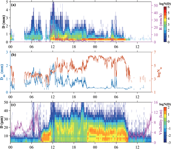
A Laser Precipitation Monitor (LPM) from Thies CLIMA was set at the observational platform of the Lushan Cloud and Fog Experiment Station in Mount Lushan (29.57°N, 115.97°E, 1080 m ASL) (Fig. 1). The LPM is a ground-based optical disdrometer with a sampling area of 45.6 cm2 and a temporal resolution of 1 min. The RSD data were collected every 1 min in a 22 × 20 matrix that recorded the raindrop numbers of each diameter and velocity bin. The diameter ranged from 0.125 mm to larger than 8 mm, and the velocity ranged from 0 to 20 m s−1.
2.2 Methods
a. LPM data quality control
The effective sampling area for laser optical sensors is affected by the border effects (Battaglia et al. 2010). In the ith size class, the effective sampling area is 228 × (20–Di) mm2 and Di (mm), which is the mean diameter for the i th size diameter class (Jaffrain and Berne 2011). The incorrect records of small particles with high falling speed are named as the “margin fallers” and detected when they partially cross the sampling area (Yuter et al. 2006). Strong winds and splashing usually cause spurious particle recording, and according to previous studies, the empirical terminal velocity–diameter (V–D) relationship is constantly used to assess and eliminate spurious records (Chen, B. et al. 2013, 2017; Ji et al. 2019). In this study, we chose the empirical V–D relationship with the air density correction factor to assess the raindrop data (Atlas et al. 1973):
where
ρ0 and
ρa (1.20 kg m
−3) are the air density at the observation level and sea level, respectively. The temperature and pressure data of the automatic meteorological station (AWS) of the Lushan Meteorological Bureau (29.57°N, 115.97°E, 1165 m) were used to retrieve the correction factor. Using the AWS data in June and the first half of July from 2016 to 2020, the average pressure and temperature during the Meiyu season were first calculated, and
ρ0/
ρa was then derived through the ideal gas state equation (
P = ρRT). Finally, a correction factor of 1.0655 was obtained. Thus, the terminal velocity
V(
Di ) of each diameter bin
Di was achieved, and the particles out of the velocity range
V(
Di) ± 0.6
V(
Di) were removed (
Friedrich et al. 2013;
Jaffrain and Berne 2011) (
Fig. 2).
b. Raindrop size distribution parameters
The raindrop size distribution is depicted as the number concentration of raindrops N (Di) (m−3 mm−1) per unit volume from Di to Di + ΔDi in size class i and can be calculated using Eq. (2):
where
nij is the number of raindrops for the
ith diameter bin and
jth velocity bin,
Ai (m
2) is the effective sampling area, Δ
t is the sampling time interval (60 s for LPM),
Vj (m s
−1) is the average velocity of the
jth velocity bin, and Δ
Di (mm) is the width of each diameter bin.
The bulk microphysical parameters total number concentration NT (m−3), rainwater content W (g m−3), rain rate R (mm h−1), and radar reflectivity factor Z (mm6 m−3) were calculated as follows:
where
ρw is the density of water (1 g cm
−3). The mass-weighted mean diameter
Dm (mm) and generalized intercept parameter
Nw (m
−3 mm
−1) were introduced to describe the bulk characteristics of RSD, which could be calculated according to
Eqs. (7) and
(8).
The gamma distribution proposed by
Ulbrich (1983) was used to describe the distribution of the raindrop size, as shown in
Eq. (9).
where
D (mm) is the diameter,
N0 (m
−3 mm
−1−µ) is the intercept parameter,
µ is the shape parameter, and
Λ (mm
−1) is the slope parameter.
In this study, a rain event was defined as when there were continuous spectra with no less than 30 min, and two events with a less than 1 h rain-free period would be regarded as 1 (Chen, B. et al. 2017; Tokay and Bashor 2010). The spectra with a rain rate of less than 0.1 mm h−1 or a total number of less than 10 would be treated as noise (Chen et al. 2013). During the Meiyu period from 2016 to 2020, a dataset of 186 rain events was derived from the quality-controlled observational data.
3. Results
3.1 RSD properties of different rain rates
The RSD of different rain rates has different characteristics (Chen, B. et al. 2013, 2017; Ji et al. 2019; Porcù et al. 2014). However, because of different geographic locations (e.g., Chen, B. et al. 2017; Ji et al. 2019) and rain types (e.g., Porcù et al. 2014; Chen et al. 2013), the RSD properties of different rain rates might vary. In this study, the rain rates were divided into five classes: 1) 0.1 ≤ R < 1 mm h−1, 2) 1 ≤ R < 5 mm h−1, 3) 5 ≤ R < 10 mm h−1, 4) 10 ≤ R < 100 mm h−1, and 5) R ≥ 100 mm h−1. Samples with R < 5 mm h−1 contributed 79 % to the total sample numbers and 22.74 % to the precipitation amount, and the samples with 5 ≤ R < 10 mm h−1 and R ≥ 10 mm h−1 were 10.25 % and 14.72 %, 10.74 %, and 62.54 %, respectively (Fig. 3). The percentages of sample counts and precipitation amounts were similar to the results for Nanjing, a city with a lower altitude in east China (Chen et al. 2013); however, there were more samples (0.32 %, 135 samples) with higher rain rates in Mount Lushan.

For large raindrops (> 0.5 mm), the number concentration increases with the rain rate and spectra rise in parallel. For small raindrops (< 0.5 mm), when the rain rates are lower than 10 mm h−1, the concentrations for smaller/larger than 0.0375 mm raindrops will decrease/increase, which concords with the “rotational movement” reported by Hashimoto and Harimaya (2003). When the rain rates exceeded 10 mm h−1, the spectra tended to expand in parallel, and the concentrations of all diameter bins will rise with the rain rate. The average spectrum is like that of 5 ≤ R < 10 mm h−1, but with a higher concentration at the smaller and larger ends of the diameter range, and a lower concentration at the middle diameter range (Fig. 4).

To compare the spectral characteristics for different rain rate classes, the standard deviation of the mass spectrum σM = Dm/(4 + µ)1/2 and normalized standard deviation of the mass spectrum σM/Dm, which were defined by Ulbrich and Atlas (1998), were used. To obtain the µ parameter from the RSD, the fitting methods were first compared. The maximum likelihood (ML) (Brawn and Upton 2007, 2008) and truncated moment (MM) (Ulbrich and Atlas 1998; Zhang et al. 2003) methods were used to estimate the parameters of the gamma distribution. The MM method fits better than the ML method in terms of RSD shape. For rain rates of < 10 mm h−1, the ML method underestimates/overestimates the concentrations for large/small particles, and the ML method also slightly overestimates the larger diameter classes (diameter > 0.5 mm) for rain rates ≥ 10 mm h−1. For the entire dataset average spectrum, the ML method overestimates the concentrations in the diameter range of 0.5–3 mm and smallest diameter class (0.125–0.25 mm) and underestimates the concentrations in the 0.25–0.5 and > 3.5 mm ranges (Fig. 5).

Table 1 presents the correlation coefficient, absolute bias, relative bias, NT, and W for the observation and fitting results for the two fitting methods. The absolute bias and relative bias were calculated following Tokay and Bashor (2010). The ML method shows significant advantages over the MM method according to the correlation coefficients and absolute biases and is similar to observed results in the Tibetan Plateau (Chen, J. et al. 2017). However, the MM method shows superior results in terms of relative biases. For NT, ML obtains better results for smaller rain rate classes (< 10 mm h−1), and MM obtains better results for larger rain rate classes (≥ 10 mm h−1). For the entire dataset, the two methods exhibit similar results. For W, the MM method shows superior results to the ML method. The results will be based on the MM method to further discuss the characteristics of Meiyu precipitation because it has advantages in terms of describing the RSD shape and estimating the precipitation.

Table 2 presents parameters and fitting results of the average spectra for different rain rates. According to Table 1, the NT and W both increase with rain rate, and in Table 2, the Z, Dm, and σM exhibit similar variations, meaning that the rising parameters have close relationships with diameter, spectra width, and rain rate. By contrast, log10 Nw and σM/Dm, which address concentration, diameter, and spectra shape, scarcely vary with rain rate. For the fitting results, N0 and Λ increase/decrease with rain rate, and µ varies little with rain rate and are negative for all rain rate classes. This differs from other observations (Chen, B. et al. 2013, 2016, 2017). The concentrations for small raindrops are slightly high and consequently lead to a left lower bending trend shape of the spectra, and negative µ values are derived (Figs. 4, 5).
3.2 Differences between stratiform and convective rains in Meiyu
a. Classification of stratiform and convective rains
It has been widely demonstrated that stratiform rains have quite different physical processes compared with convective rains (Bringi et al. 2003; Chang et al. 2009; Chen, B. et al. 2013, 2017; Ji et al. 2019; Zhang et al. 2019), as well as microphysical schemes and retrieval methods in remote sensing (Atlas and Ulbrich 2006; Chen, B. et al. 2017; Dolan et al. 2018; Rosenfeld and Ulbrich 2003; Ulbrich and Atlas 1998). To determine the differences between stratiform and convective rains, two classification schemes were considered, namely, the T01 scheme (Testud et al. 2001) and the B03 scheme (Bringi et al. 2003). For a rain rate time series {Ri}, in the T01 scheme, if Rk and adjacent 10 spectra (Rk−5–Rk+5) are all less than 10 mm h−1, then the spectrum k will be classified as stratiform; otherwise, the spectrum k will be classified as convective. As to the B03 scheme, if the standard deviation (σR) of 10 consecutive spectra is no larger than 1.5 mm h−1, then the 10 consecutive spectra will be classified as stratiform, whereas when the σR is larger than 1.5 mm h−1 and the rain rate is no smaller than 5 mm h−1, the spectrum will be classified as convective.
For the entire dataset (42,474 RSD samples), 33,518 (78.9 %) samples were classified as stratiform and 8956 (21.1 %) samples were classified as convective rain according to the T01 scheme. Using the B03 scheme, 30,127 (70.9 %) samples were classified as stratiform and 7866 (18.5 %) samples were convective. T01 is a proper way to classify all samples to stratiform or convective rain, but the B03 scheme allows a higher rain rate to be classified as stratiform rain. The convective sample ratios for the stratiform samples were 26.1 % and 26.7 % for the T01 and B03 schemes, respectively, which were almost the same.
Figure 6 displays the distributions of Dm and log10Nw frequency of stratiform and convective RSD samples. For the entire dataset, the frequency of Dm peaks at 0.5–0.6 mm and 1.0–1.1 mm and the mean value, standard deviation, and skewness for Dm are 1.20 mm, 0.57 mm, and 1.03, respectively. Compared with the results of Chen et al. (2013) and Bringi et al. (2006), the mean Dm is smaller, whereas the standard deviation and skewness are larger in Mount Lushan. For log10Nw, the peaks are 3.5–3.6 and 5.0–5.1, and the mean value, standard deviation, and skewness are 3.88, 0.80, and 0.74, respectively. The mean log10Nw, which is close to the Marshall–Palmer value (8000 m−3 m−1 for Nw), is similar to Chen et al. (2013), but has a higher standard deviation and skewness. The bimodal distribution of Dm frequency was reported by Wen et al. (2016) and is caused by shallow rain. Furthermore, the frequency of log10Nw exhibits a second peak. This was also reported and attributed to shallow rain by Wen et al. (2016) and Fu et al. (2020). In the present study, the elevation of Mount Lushan will result in insufficient coalescence and thus, reduce the concentration of large raindrops. Also, it is easier for precipitating clouds to reach the ground because of the elevation, lack of evaporation in a saturated environment will increase the concentration of small raindrops. Hence, the second peak of log10Nw in Mount Lushan can be affected jointly by shallow rain and the elevation of mountain topography. Moreover, the first peak in the present study differs from some Meiyu studies (Fu et al. 2020; Wen et al. 2016). The higher standard deviation and skewness also indicate significantly higher RSD variability in Mount Lushan during the Meiyu season.

The stratiform–convective rain type classification methods of T01 and B03 were compared (Fig. 6), and the frequencies of Dm and log10Nw for stratiform and convective rains of both methods exhibit similar results. The average value, standard deviation, and skewness of Dm of T01/B03 methods are 1.04/1.02 mm, 0.44/0.49 mm, 1.04/1.02, and 1.77/1.87 mm, 0.61/0.58 mm, 0.96/1.23 for stratiform and convective rains, respectively. For log10 Nw, the average value, standard deviation, and skewness of T01/B03 methods are 3.91/3.93, 0.86/0.88, 0.70/0.70, and 3.76/3.77, 0.52/0.49, −0.24/−0.24 for stratiform and convective rains, respectively. There is no essential difference between the two methods; however, the B03 scheme displays more distinct stratiform/convective characteristics. Thus, here, the B03 scheme is considered as the classification method.
The difference between the stratiform and convective rains mainly manifests in the different peaks of the frequency distributions for Dm and log10 Nw. However, different peaks and skewness of frequency distributions for Dm and log10Nw have been found among different geographical locations (Bringi et al. 2006; Chen et al. 2013; Fu et al. 2020; Wen et al. 2016) in both stratiform and convective rains. Larger standard deviations for Dm and log10Nw were obtained, indicating a more notable variety of RSD in Mount Lushan during the Meiyu season because of the mountainous topography.
The distribution between Dm and log10Nw exhibits characteristics similar to those of other Meiyu RSD studies along the Yangtze River Valley (Fig. 7) (Chen et al. 2013; Fu et al. 2020; Wen et al. 2016), which is generally more stratiform-like. Compared with other Meiyu researches, there are more samples with larger log10Nw and lower Dm values in the Mount Lushan dataset (Bringi et al. 2003; Chen et al. 2013; Fu et al. 2020; Wen et al. 2016). A larger standard deviation of log10Nw for stratiform rain and a smaller standard deviation of Dm for convective rain were found in the present study, but the mean log10Nw values were quite close. Compared with other related Meiyu precipitation studies (Chen et al. 2013; Fu et al. 2020; Wen et al. 2016), the present study obtained a smaller mean Dm for stratiform rain but a larger mean Dm for convective rain, indicating that the variety of Dm is larger in Mount Lushan. For the mean Dm–log10Nw pairs of all data in each study, all studies are similar and fall along the stratiform rain line proposed by Bringi et al. (2003) in the Dm–log10Nw coordinate. No significant tendency for maritime or continental characteristics can be found in the Meiyu precipitation (Bringi et al. 2003, 2009; Thompson et al. 2015).

The relationship between Dm–R and Nw–R was investigated (Fig. 8). Dm increases with rain rate for both stratiform and convective rains, and the power fitting results show little difference between the two rain types, which is similar to other Meiyu observations (Chen et al. 2013; Fu et al. 2020). The exponential fitting coefficients are higher than those of Chen et al. (2013) and Wen et al. (2016), indicating that Dm increases faster with R at higher rain rates. The Nw of stratiform rains shows little variation with rain rate, whereas for convective rains, Nw shows a rising trend at lower rain rates. Compared with other studies, the exponential fitting coefficients in the present study are quite low (Chen et al. 2013; Fu et al. 2020; Wen et al. 2016), particularly for stratiform rains.

Dm and Nw both show bimodal type distributions (Figs. 8a, b), which correspond to the frequency distributions of stratiform rains (Fig. 6). The high Nw peak (Fig. 8a) corresponds to the low Dm peak (Fig. 8b). To investigate the unique high Nw samples, a subset consisting of samples with log10Nw > 4.5, was evaluated from stratiform rains for further analysis (Figs. 8a, b). The exponential fitting coefficients of the subset between Dm and R are the same as those of stratiform rain but with a lower primary coefficient, and Nw shows little variation with R.
The average spectra of the subset of log10Nw > 4.5, log10Nw < 4.5, and the entire stratiform rain are presented in Fig. 9. The concentrations of smaller/larger (divided by 0.875 mm) for the subset with log10 Nw > 4.5 are higher/lower than those of log10Nw < 4.5, and the subset with log10Nw > 4.5, has a narrower spectrum width. Rosenfeld and Ulbrich (2003) summarized the processes that can modify the shape of RSD and stated that typically, coalescence and evaporation cause a decrease in small raindrops. For the samples with Nw > 4.5, the narrow spectrum width and high small raindrop concentrations are the result of a lack of coalescence. When precipitation occurs within a cloud, the RSD spectra will always be narrow and with high concentrations for small raindrops because of insufficient coalescence and the absence of evaporation. This type of precipitation is frequently seen in Mount Lushan, and therefore, it can be assumed that the high-Nw subset is the result of in-cloud precipitation.

The average spectrum of convective rain shows higher concentrations than stratiform rain, whereas the differential concentrations rise with diameter (Fig. 10) (Table 3). Compared with other studies conducted at lower altitudes along the Yangtze River Valley (Chen et al. 2013; Fu et al. 2020), the concentrations of raindrops in Mount Lushan are higher at the small diameter end than particle size velocity (Parsivel) measurements, and this can be attributed to raw particle size and fall velocity distribution differences estimated by two sensors (Angulo-Martínez et al. 2018, see in Table 4). Furthermore, compared with Chen et al. (2013) and Wen et al. (2016), higher raindrop concentrations at the large-diameter end were also obtained in Mount Lushan and may be related to the mountainous topography.

The gamma distribution fits quite well for both rain types, except for the underestimation of the first diameter bin class (Fig. 10). The N0 and µ for stratiform rains are higher than convective rains, and the Λ for stratiform rains is smaller than convective rains. Compared with Chen et al. (2013), N0 and Λ are significantly lower in Mount Lushan, and µ is negative for both rain types, indicating that the spectra are bent toward the left bottom. The differences between the present study and those of Chen et al. (2013) can be attributed to the high concentration of small raindrops resulting from the mountainous topography of Mount Lushan.
3.3 Relationships of gamma distribution parameters
Theoretical calculations and observational results both show that the parameters of gamma distribution are not independent (Atlas et al. 1973; Chandrasekar and Bringi 1987; Chen, B. et al. 2017; Haddad et al. 1996; Seela et al. 2018; Ulbrich 1983; Zhang et al. 2003). To investigate the relationships between the gamma distribution parameters and the distinctiveness of RSD in Mount Lushan, the relationships between µ–N0 and µ–Λ were analyzed (Fig. 11).

It has been found theoretically and empirically that N0 and µ have an exponential relationship of N0 = CN exp (3.2µ), where CN is a constant (Ulbrich 1983). The distributions of the two parameters show an obvious exponential relationship, and the fitting equations for stratiform rain, convective rain, and the entire dataset are N0 = 3720 exp (1.70µ), N0 = 7406 exp (1.29µ), N0 = 13043 exp (1.45µ), respectively (Fig. 11). Compared with Ulbrich (1983), the present study shows a lower exponential coefficient, but the CN here is of the same order of magnitude. However, when compared with the dataset on the Tibetan Plateau (Chen, B. et al. 2017), the exponential coefficient is similar, but a higher CN was found in Mount Lushan. The differences between the three studies indicate that although µ–N0 has an exponential relationship, the fitting results vary significantly among different regions and rain types, and it is inconvenient to assess the varieties because N0 will change with µ (Chen, B. et al. 2017).
Zhang et al. (2001) and Zhang et al. (2003) proposed a quadratic polynomial µ–Λ relationship (Λ = 0.0365µ2 + 0.735µ + 1.935), which is thought to be a fundamental property of RSD, especially in convective rain (Seifert 2005). The µ–Λ relationship varies according to geographic location, climate regime, and synoptic system (Bringi et al. 2003; Chen et al. 2011; Chen, B. et al. 2013, 2016, 2017; Ji et al. 2019; Luo et al. 2020). The µ–Λ relationship for stratiform rain, convective rain, and the entire dataset of this study are presented in Fig. 11b. The fitting equations for three datasets are Λ = 0.0211µ2 + 1.365µ + 2.374, Λ = 0.0533µ2 + 0.974µ + 2.281, and Λ = 0.0347µ2 + 1.180µ + 2.495, respectively. The µ–Λ of stratiform rain is similar to the results in the Tibetan Plateau, which is Λ = 0.0217µ2 + 1.090µ + 1.706, but with a higher constant coefficient (Chen, B. et al. 2017). The µ–Λ of convective rain in Mount Lushan is similar to the result of a squall line case in eastern China, which is Λ = 0.0585µ2 + 0.812µ + 1.934, also with a higher constant coefficient (Chen et al. 2016). Compared with the results of Zhang et al. (2003), the quadratic coefficient for the entire dataset here is similar, but the primary and constant coefficients are higher. However, in Chen et al. (2013), which is Λ = 0.0149µ2 + 0.491µ + 2.015, all coefficients differ from Mount Lushan. The present study shows that under conditions using different instruments, the similarities of the µ–Λ relationship can still be assessed for different geophysical locations, climate regimes, and synoptic systems.
3.4 Z–R relationship
The Z–R relationship, in the form of Z = ARb is an important criterion in radar QPE (Chen et al. 2013; Porcù et al. 2014; Tokay and Short 1996), and here, the Z–R relationship in Mount Lushan was investigated (Fig. 12). The Z–R relationship for the entire dataset is Z = 203R1.59 (Fig. 12a), which is similar to the continental stratiform rain Z = 200R1.6 (Marshall and Palmer 1948), and indicates that the Meiyu precipitation in Mount Lushan is typically stratiform-like. The Z–R relationships for stratiform and convective rains are Z = 194R1.53 and Z = 198R1.63, respectively, which are also similar to those of stratiform rain, although there are minute differences (Marshall and Palmer 1948). When comparing the operational WSR-88D Z = 300R1.4 (Fulton et al. 1998) and Meiyu results in eastern China Z = 368R1.21 (Chen et al. 2013), the rain rate R derived from Z will be overestimated/underestimated at lower/higher rain rate ranges (dividing rain rate approximately 5–10 mm h−1) in Mount Lushan. The Meiyu precipitation in Mount Lushan can be generally characterized as typical stratiform rain.

The samples with log10Nw > 4.5 show significantly different characteristics, and therefore, the differences between samples with log10Nw > 4.5 and log10Nw < 4.5 were investigated. The Z–R scatterplots show a clear boundary between samples with log10Nw > 4.5 and log10Nw < 4.5, for the entire dataset (Fig. 12a) and the stratiform dataset (Fig. 12b). The Z–R relationships of samples with log10Nw > 4.5 for the entire dataset and stratiform rain dataset are Z = 54R1.47 and Z = 51R1.41, respectively, showing little difference. The characteristics of the spectra and Z–R relationship for the high Nw samples are similar to the shallow rains diagnosed by Wen et al. (2016), and were attributed to warm rain processes. For those with log10Nw < 4.5, the Z–R relationship for the entire dataset is Z = 306R1.51, which is similar to that of WSR-88D (Fulton et al. 1998), but with a higher b value. The Z–R relationship for stratiform rain samples with log10Nw < 4.5 is Z = 203R1.59, which is very similar to continental stratiform rain (Marshall and Palmer 1948). The Z–R relationship for the high-Nw subset in the present study shows a higher rain rate at the same Z value. Yuter and Houze (1997) reported a bimodally distributed Z–R relationship in the Pacific Warm Pool, which corresponds to the populations of large and small drop spectra. The present study also revealed a similar bimodal distribution but with a significantly lower rain rate. The underlying reason should be further investigated.
5. Conclusions
Using the RSD data collected by LPM in Mount Lushan from 2016 to 2020, the RSD characteristics of Meiyu precipitation in Mount Lushan were studied. The special RSD samples with high Nw were also discussed, and the results are as follows:
A dataset of 186 rain events was determined during the Meiyu season from 2016 to 2020 in Mount Lushan. For the entire dataset, lower rain rates (< 5 mm h−1) contributed to the highest number of samples, whereas rain rates of 10–100 mm h−1 contributed the highest precipitation amount. Extraordinarily high rain rates (> 100 mm h−1) were found in Mount Lushan during the Meiyu season and contributed to quantitative precipitation (8.62 %) compared with its low frequency (0.32 %). For large-diameter ranges (> 0.5 mm), the concentrations for each diameter bin of the average spectra will increase with rain rate, whereas for small diameter ranges (< 0.5 mm), the concentrations for each diameter bin will rise only when the rain rates are higher (> 10 mm h−1).
The performance of the two gamma fitting methods, namely, the ML and MM, were evaluated using the average spectra of each rain rate class for the Meiyu dataset. The ML method obtained better results for correlation coefficients and absolute biases, and the MM method obtained better results for relative biases and shapes of RSD. In simulating the RSD parameters, the MM method had good results for NT and W. Thus, the MM method achieved good results for simulating the Meiyu RSD in Mount Lushan.
The RSD parameters of NT, W, Z, Dm, and σM increased with rain rate, whereas Nw and σM/Dm varied little with rain rate. For the gamma distribution parameters of the average spectra for different rain rates, N0 and Λ rose/decreased with rain rate, and µ had negative values for all rain rate classes. The gamma distribution for the average spectrum of the entire dataset was N(D) = 721D−1.79e−1.20D. The frequency distributions of Dm and log10Nw both showed a special bimodal type. An exceptionally high-Nw (log10Nw > 4.5) subset was diagnosed, which corresponds to the unique secondary peaks of Dm and log10Nw, which has a narrower and steeper average spectrum with high concentrations for small raindrops (< 0.875 mm).
Two classification schemes (T01 and B03) for stratiform/convective rain were discussed, and the frequency distributions of Dm and log10Nw for stratiform and convective rains showed little difference between the two schemes. The distribution of Dm–log10Nw showed differences between the two rain types and no significant maritime/continental characteristics. The Dm–R and Nw–R relationships showed little difference between stratiform and convective rains, and Nw showed little variation with rain rate. The average spectra for stratiform and convective rains both had high concentrations of small raindrops, but the convective rains had larger raindrops. The gamma distribution parameters were also calculated (Table 3).
The relationships between the gamma distribution parameters of µ–N0 and µ–Λ for stratiform and convective rain were examined. The µ–N0 showed quite different characteristics for stratiform and convective rains, and the fitting equation for the entire dataset was N0 = 13043 exp (1.45µ). The Meiyu dataset of Mount Lushan showed a similar µ–Λ relationship (Λ = 0.0347µ2 + 1.180µ + 2.495) to other studies, but in the present study, the lower µ values resulted in higher primary and constant coefficients in the quadratic polynomial fitting results.
The Z–R relationship for the Meiyu season in Mount Lushan showed featured stratiform rain characteristics with a Z = 203R1.59 fitting result. The Z–R relationships for stratiform and convective rains showed little difference, but the dataset of high Nw samples obtained a unique fitting result of Z = 54R1.47.
The high-Nw subset was normally detected in long-lasting precipitation during the Meiyu season. The RSD can be characterized as high concentrations in the first two diameter classes, with narrow spectrum width (< 1 mm), and low but continuous rain rate (< 5 mm h−1). Further investigations demonstrated that these samples can be attributed to in-cloud precipitation, which is related to the mountainous topography of Mount Lushan.