Abstract
Gender segregation is considered a significant problem in the modern period, where urban planning may play a role in facilitating male and female use of public spaces, or overlook their different needs in the city. Urban spatial use has been linked to many factors in previous studies. One important factor to consider here is the pattern of land-use and its capability of affecting the movement behaviour of people in the city. In space syntax theory, it has been assumed that the distribution of shops exists to take advantage of people’s movement, which is generated by the urban structure itself. In this regard, this paper aims to identify the factors behind land-use segregation between shops for each gender in the city centre of Biskra, and whether this has resulted in gender segregation in urban spatial use, leading to the distinct location of services within the city centre, creating men’s and women’s spaces. This investigation has been conducted by using surveys of shops as well as syntactic analyses, paired together in order to reach an understanding of this phenomenon. The findings showed that at a global scale, the higher the street is integrated, the higher the land-use mixture tends to be, while at a local scale there was no correlation found in term of men’s and women’s segregation of land-use, which may rather be related to locals using their prior knowledge of a space rather than the information cues provided by its structure.
Introduction
When talking about urban planning and design, it is important to think of an urban space as various elements rather than a single one; commercial centres, plazas, parks and so on, all combined in a homogeneous way to generate and affect the social and economic life that exists inside this entire network. In this interdependence, we can say that streets work as connectors between these elements, therefore, accommodating and designing streets is as important as connecting the elements themselves, given that this network affects human behaviour differently, i.e. to offer better accessibility or to deny it from a certain space (Monokrousou & Giannopoulou, 2016).
Urban spaces have been of great interest to many scholars from many fields, where their functioning and use by people represents the central challenge. This pertains to the understanding of how people use an urban space and interact with it (by occupying a space and conducting an activity in its broader sense), and has been covered by ‘person-environment’, ‘man-space’ or ‘space-action’ interaction studies. Many studies have linked the use of urban spaces and people’s choice and preference to the comfort aspect related to ambience characteristics, perception, aesthetics, an environment’s visual field, and even to spatial configuration (Boumezoued, Bada, & Bougdah, 2020; Marcus & Francis, 1997). However, there are only few researches that have really carried out studies on people’s behaviour and pattern of activities related to gender and men’s and women’s use of space (Garcia-Ramon, Ortiz, & Prats, 2004; al Ghatam, 2012; Güney, 2014; Güney & Kubat, 2015; Hanson, 2010; van den Heuvel et al., 2020; Hidayati, Tan, & Yamu, 2020; Jo, Lee, & Kim, 2020; McDowell, 1983; Nguyen & Van Nes, 2013), as they showed that people’s spatial use is dependent somehow on either the services and activities provided in the space or on the street’s structure solely. In this regard, these factors can affect both genders differently to stimulate them in regard to which spaces they prefer to use and fulfil their needs, and if not well managed, a spatial separation appears, a disparate density of use and distinct locations of facilities for each group within the urban area. These men’s spaces and women’s spaces would also have a multiplied effect on patterns of movement for both groups, which would be restrictive to some areas of the city alone.
For a long time, women have been seeking for equivalence between genders, and although they have gained some rights in terms of equality, and to varying degrees globally, many still do not have full freedom and cannot just wander in city’s as they desire; some spaces cannot be reached, and sometimes spaces can feel unsafe (Nguyen & Van Nes, 2013). In several cultures, men’s main role is to be the breadwinners in the family, where they are supposed to go to the city and work, while the private interior spaces are identified as spaces for women to stay in and be primary caregivers of their children as their main job (Güney & Kubat, 2015). Gender segregation in the city has always been embedded as a part of Muslim culture and tradition, where women have long been confined to the domestic sphere. However, this phenomenon seems to have begun changing under the influence of societal developments. Women's access to public spaces is now very noticeable in cities of the Arab world, even in those that are still dominated by patriarchal structures (Ladier-Fouladi, 2004; le Renard, 2012). In Algeria, the modernization movement that has been occurring since independence and the sociological changes that have resulted from it have profoundly affected the traditional structure in the country leading to more adaptation of a western lifestyle (Benzerfa-Guerroudj, 1992). Even though this phenomenon has not been accompanied by a greater presence of women in the labour market, the education and health sectors however are currently 80% female (Kateb, 2011). This social phenomenon in the city was and is still considered as a significant problem in the modern period, where urban planning might play a role in ignoring women in public spaces, as they overlook their needs and experience in the city (Garcia-Ramon et al., 2004; McDowell, 1983). This would also affect the security aspect, causing more fear, aggression, street harassment, violence and so on.
In the city of Biskra, we can notice this phenomenon of segregation, especially in the city centre and in locations that gather retail activities as ‘Zgag Beramdane’, where women head in different directions to the men from the moment they enter the centre, leaving some spaces abandoned from the opposite gender, and leading to streets that cater for their needs only; streets with specific shops and services exist only for men or for women. Moreover, there is also a separation in retail distribution, which removes any reason for women to wander in some streets that do not concern them. In view of this reality, this research takes the city of Biskra as a case study to look into the issue of gendered land-use, relying principally on a space syntax method paired with surveys from local areas.
Conceptual background
Space syntax, movement and land-use
Before we get to the process of investigation, it is necessary to talk about the principal method in this study and its relation to movement and land-use patterns of distribution, given that movement is considered as an important element in urban planning. Since it effects the dynamicity and liveliness of urban spaces, the appropriate distributing and accommodating of movement is an important factor (Peponis, Ross, & Rashid, 1997).
Space syntax is a graph-based theory, initiated and developed in the Bartlett school of Architectural studies, University College London. As many studies have shown, space syntax tends to express the relationship that exists between society and the physical spatial structure, in fact it has helped with interpretations of several socio-spatial phenomena, such as urban movement, crime and social segregation. Hillier and Hanson et al. (1983) believed that there are underlying powers that generate movement in the space rather than the ordinary linguistic concepts such as hierarchies and regularized geometries. After they studied the implications of the physical structure of space, they coined the concept of ‘natural movement’ and explained how movement is generated by the spatial configuration of the urban space. Furthermore, space syntax theory suggests that cities are mostly shaped by socio-economic forces, it argues that commercial activities and attractions are also a street network effect (Figure 1) that exists to take advantage of and profit from the movement generated by the spatial configuration, which has been referred to as the ‘movement economy’ phenomenon (Hillier et al., 1993; Hillier & Iida, 2005). As a matter of fact, 60%-80% of research has correlated movements in urban spaces with the integration value (Hillier et al., 1993; Hillier & Iida, 2005; Penn et al., 1998; Peponis et al., 1989), which has shown how the urban network alone is capable of being a source for predicting the movement generated, while ignoring secondary factors. Other studies however have shown that several factors could play a bigger role in movement prediction (Choi & Koch, 2015; Lerman & Omer, 2013; Monokrousou & Giannopoulou, 2016; Özbil & Peponis, 2007).

The Urban Land Institute (1987) defines the concept of ‘mixed land-use’ as the diversity of functions and activities in the same local urban space. In western countries, mixed land-use has an important value, keeping the density of users balanced in the different areas of the city. It creates vitality, liveability, attractiveness, and even improves the security in some areas that have been otherwise abandoned by people (Hoppenbrouwer & Louw, 2005). From retailers’ point of view, the choice of store locations is considered as a significant decision in order to enhance their chances of success in their work. There are many factors that can affect the location selection such as the cost of land/rent, the accessibility, and the pedestrian flow (Brueckner, 1993).
In line with the queries of this study, this section will consist of going through some of the prior research related to the theories of space syntax mentioned earlier. Shu-Wei Huang and Hsiu-I Hsieh (2014) studied the relationship between accessibility and mixed land-use in the city of Tainan through a comparison of the mixed land-use degree in an area with different parameter values using the space syntax method; correlation analysis confirmed that the degree of mixed land use in Tainan has a high positive correlation to global integration and connectivity values. In other research, by Güney (2014), a correlation analysis between pedestrian movement observations and visibility graphs was conducted in order to understand the use of urban space based on gender differences in a small Anatolian city: the results showed that men were always higher in density, and women preferred to use only visually integrated streets in their leisure activities. Ortiz-Chao (2008) examined land-use patterns in Mexico City with a plot accessibility model (at the micro scale) in relation to its syntactic attributes. The findings showed that the distribution of land-uses responds to the theory of movement economies, where the commercial activities benefit from streets with high movement, i.e. higher accessibility. Research that was conducted in four Dutch towns (Nguyen & Van Nes, 2013) showed that there is a correlation between the syntactic graphs and the gate counts of pedestrians, where the more the street was integrated, the more the public (both men and women) went there as a destination, but the more the street was segregated the more it was dominated by men. However, it was noteworthy that after the stores and the activities that existed in the street were gone, it became a place only for men, where women had no more reasons to go out. Remarkably, in the city centre of Sharjah, UAE (Güney & Kubat, 2015), when no correlation between the observed movement of men/women and the syntactic values was found, it was suggested that the pattern of movement is related to land use factors (shopping centres, banks, etc.), as it was dominated by men while women showed the lowest volume. A study in downtown Konya, Turkey, correlated real estate values with spatial configuration before and after a pedestrianisation process in an important avenue. The results were an increase in all values of commercial areas while, on the other hand, the shops which depend on vehicular traffic have decreased, which meant that the urban design project and the increased integration values brought economic vitality for pedestrians (Topçu, Topçu, & Kubat, 2007). To examine how pedestrian movement is generated in relation to the urban structure alone, an analysis was conducted using the space syntax method by Monokrousou and Giannopoulou (2016). It showed, however, the inefficiency of the space syntax method to predict movement in the studied area, given that the attractors play a huge role in the generation of movement in some areas. In another paper, the authors studied the relationship between the distribution of commercial activities and the spatial configuration in Cairo to see to what extent the commercial activities were affected by the spatial accessibility in both informal and planned areas (Mohamed & van Nes, 2017). It appeared that the commercial activities in the planned areas tended to spread along the internal routes with a high segregation potential. However, in spontaneous settlements, retail was distributed in an orderly way along the most accessible streets.
All these studies show the effect of the urban system and the distribution of attractions on users, as they are affected differently, and show that often other factors play even a bigger role than the spatial configuration. This study, however, will focus on the distribution of commercial activities from a gender categorising point of view, correlated with the syntactic analyses, based on the assumption that spatial configuration could affect the land use distribution, according to movement economies theory.
Case study presentation
Biskra is a Saharan city that is characterized by its hot and arid climate most of the time. Situated around 430 km south of the capital Algiers, its morphology is a combination of three different types of urban fabrics: the gridiron fabric, which is a result of the colonial period, the irregular fabric, coming from the extension of the old nucleus, and finally the modern fabric (Bada & Guney, 2009). The main area for this investigation is the city centre district (Figure 2), a dynamic area in the city with several open spaces such as El-Houria Plaza, El-Dalaa Plaza, and other commercial centres, including the ancient and popular commercial centres. One of the main reasons for analysing the city centre (Figure 3) is the diversity of urban fabrics and structure which would be a relevant factor to the spatial configuration and land-use distribution. By virtue of being traversed by Zaatcha and Emir Abdelkader Boulevards (the main structuring axes of the city), and also because of the existence of several commercial activities (retail), the city centre is considered to be the most dynamic area in the city, with a high potential of pedestrian movement overall. It is also important to mention that the main focus of this study will be on the streets generated by the city’s morphology and the relations that exist between them in three local areas (Figure 3).
Most areas of the case study have not been planned for commercial activities, they were principally residential areas whose houses, of certain specific streets and chosen by retailers, were transformed to shops over decades. Therefore, the current commercial areas are result of expansion over decades
Zgag Beramdane (area no. 1) has a high level of accessibility as it is surrounded by the main streets of the city (Zaatcha and Emir Abdelkader Boulevards) with multiples entrances. This area is part of the post-independence fabric and consequently, it is easy to notice the compactness of streets and also the irregular pattern of layout with several dead ends inside the layout. These streets are mostly for pedestrian use and often vehicles use it to traverse to the opposite side of the area. Although Zgag Beramdane is mostly dedicated to clothing stores (in the internal routes), it is also a highly residential area and most of the stores are owned by locals, if not rented. All this makes this area worthy of investigation.

El-Boukheri (area no. 2) is considered as a destination mostly to women as it contains several retail stores that cater to their needs (clothing stores, utensils, etc.). Due to its connection with Zgag Beramdane, this area also has an irregular spatial pattern (post-independence fabric) with a compact urban layout whose streets favour privatisation from the public mixed spaces. The accessibility to this area is mainly from the main boulevard of Zaatcha or through the internal streets that are connected with Zgag Beramdane. These streets are usually used by local pedestrians, with a really low density of vehicles. El-boukhari also holds the ‘Saturday market’ (Soug Sebt) for which the number of shoppers increases significantly.

Area no. 3 has been chosen for being a well-known centre for commercial activities in the city of Biskra. Due to being a part of the colonial sector, its layout was designed on the basis of a checkerboard fabric with a ‘colonial’ architecture style which produced several equal plots with different functions. The land-use here exhibits a variety of commercial activities, and in the middle of this area there is the ‘Covered market’ surrounded with grocery stores as an extension. The nearby streets, on the other hand, are mostly clothing stores for men, restaurants and food wholesalers. With its connection to Emir Abdelkader Boulevard, this area is provided with many entrances toward the centre as well as the other side. However, vehicles inside this area are almost non-existent as it is mostly used by pedestrians, strictly men. Another important element here is El-Houria plaza. This plaza is frequently used by the public with a layout of two levels that provides many sitting places and a vast open space on the top level. Putting a spotlight on this plaza is important to see how well an integrated space could affect the overall spatial use in the area.
Methodology
How and why are commercial activities distributed in such a segregated manner? Does spatial configuration control this distribution? To answer these queries, this investigation will rely principally on applying a space syntax method by using Depthmap software to study the urban configuration in the city centre of Biskra and its correlation with the distribution of retail and commercial activities by gender specification. Hence this study is structured into three parts. The first one consists of the recording and locating of shops regarding their gender classification. The second part is the syntactic analysis which will be at the district scale (the city centre) and three areas at the local scale (El-Boukheri, Zgag Beramdane, ancient commercial centre) to see how these local areas are connected to the rest of the city centre based on the assumption that a multiscale focus syntactic analysis reveals more detailed results on the spatial configuration properties. Also, these areas are zoned within a 200-meter radius. Finally, is the distribution of commercial activities correlated with the syntactic graphs.
Results
Survey of shop distribution
The qualitative approach of this investigation consists of recording and locating the retail regarding their gender classification. The distribution of commercial activities in the city centre has been done by visiting the areas several times and by identifying the types of stores on the ground level floor. The criteria for the classification of the gender type of these stores are the activity provided in the store itself, where we always have to ask the question whether this store caters for women’s needs, men’s needs, or both-genders’ needs. For example, the category of stores for women are: clothing stores for women, coiffures for women, and other small activities only for women, and the same criteria apply to men and both-gender stores.
As it appears in Figure 4, men’s stores are clustered in both commercial centres, the ancient and the popular ones, whereas women’s stores appear to be distributed in the commercial centres within the irregular fabric only. For both-genders’ stores they are distributed everywhere and more precisely in the main streets as well as closer to commercial centres. Moreover, it is easy to spot the segregation between commercial activities in the internal routes where each street offers stores for a single gender only. When we look into the numbers of the stores (Table 1), men’s stores have the lowest percentage among the three categories, coming after women’s stores, and then both-genders’ stores with the highest percentage.
Table 1. Number of commercial activities in the city centre of Biskra by gender classification
|
Store Categories
|
|
|
Men |
Women |
Both-genders |
Total |
| Number |
247 |
530 |
863 |
1640 |
| Percentage |
15% |
32% |
53% |
100% |
Syntactic Analyses
Concerning the quantitative approach adopted, a spatial configuration study is conducted mainly through axial and segment analyses. These analyses are carried out by using Depthmap software to generate axial maps as well as segment maps. In axial maps, space (street) is represented by a set of axial lines (lines of sight), passing through each space in the system and linking them all together. In this study the maps are composed of the fewest and the longest axial lines which take up the most possible routes and paths in the urban space. Later, the axial maps are converted into segment maps, which give finer and much detailed results than the axial map does at a local scale, as segment maps interpret values between each junction rather between every axis, giving a more effective model to predict accessibility (Hillier & Iida, 2005). Thus, segment maps will be used at the local scale. The considered parameter in this study is ‘integration’ (known as to-movement outside of space syntax). This is defined as the average depth that exists between an axis (or a segment) and all other axes in a single system. When studying movement, integration defines the terminal point to be reached from an origin. This measures the attractiveness and the accessibility of a space compared to its environment. Moreover, the ‘integration’ parameter itself will be interpreted in multiple radii: the radius Rn indicates the relation between a node and all other nodes in a system (the whole studied section), while R3 calculates values within three nodes in a system. According to Hillier (1996), the best way to predict the pedestrian movement at a local scale is by using the integration parameter with a radius of three steps (R=3). Thus, the studied area is analysed considering both global and local scales (Rn, R3) to see how pedestrians’ movement is affected in both scales. In the graphs, the warm colours (from red) indicate the most integrated spaces, while the cold colours (from blue) indicate the segregated ones. Generally speaking, the integrated lines are likely to be active and more used by people.
City centre
As the axial map of integration shows at the city centre level (Rn), both the colonial sector and Zgag Beramdane seem to have a good relation to the main streets of the city (Zaatcha and Emir Abdelkader Boulevards) which appear in Figure 5 and are the most integrated axes in the area, with values of, respectively, 2.461 and 2.657, at the global scale, and 3.426 and 3.591, at the local scale. Relatively speaking, these integrated streets are believed to be a better location for commercial activities than the segregated ones since they are the most accessible and attractive streets in the system (According to the Movement Economy concept): they offer an optimal location for sellers to take profit from through-travellers as well as locals. Simultaneously, the internal streets inside El-Boukheri appear to be segregated with a value that reaches 0.689, nevertheless, at the local scale (R3), they show a better relation with Zaatcha Boulevard. Moreover, the three commercial centres appear to be more integrated and have fairly good relations with main streets, going from an average of 1.807 (Rn) to 2.467 (R3) in Zgag Beramdane, for instance (Table 2). In the spontaneous fabric we also see an integrated street in the centre of the area which appears with other two streets in El-Boukheri. We can say that these streets, being more highlighted at a local scale, means that they provide even a higher accessibility into these internal areas, which could be used more by locals.
Table 2. Syntactic values from the axial maps of the city centre of Biskra
|
Values
|
| Integration Rn
|
Integration R3
|
| Zaatcha Boulevard |
2.461
|
3.426
|
| Emir Abdelkader Boulevard |
2.657
|
3.591
|
| Zgag Beramdane avg. |
1.807 |
2.467 |
| El-Boukheri avg. |
1.501 |
2.278 |
| Ancient commercial centre avg. |
1.590 |
2.161 |
 Local areas
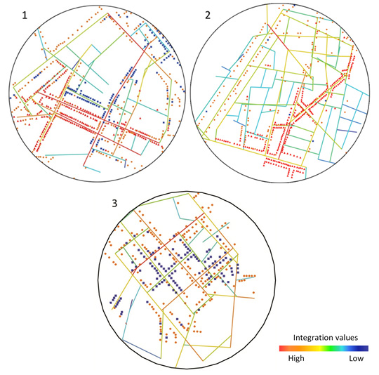
In this section, the chosen local areas are analysed through angular segment graphs and by using a global metric radius (Figure 6). Angular segment integration calculates the closeness of a segment with the entire network in terms of angular changes between each route. It is important to mention that integration values here will be normalized (Hillier, Yang, & Turner, 2012), as this method has been used specifically when comparing different urban systems with each other even when they are different sizes.
The first area (Figure 6) has been chosen for being one of the most important areas of commerce and retail activities in the city of Biskra. The phenomenon of segregation here is extremely noticeable as every street offers retail for a single gender exclusively. In Zgag Beramdane, we see more integrated streets going towards the centre of the area (average value of 1.601), while the more turns we take inside the area, the more streets become more segregated. Moreover, only a couple of segments from the main streets show a higher level of integration, and they are connected with the internal integrated streets as well.
El-boukheri exhibits somewhat random values dispersed over the whole area. the only remarkable observation concerns the two integrated segments that are shown in red (with values around 1.850), in which they seem to work as entrances toward the inside of the area from Zaatcha Boulevard, while the overall segments have an average value of 1.566 distributed between the main street of Zaatcha, and otherwise in the internal streets. However, as in the previous area (Zgag Beramdane), when we go deeper inside the area we see more segregated streets (in blue) that are used mostly for residence.
In the ancient commercial centre (area no. 3), this time the centre of the area (Covered market) looks less integrated in comparison with the rest of the segments in the area, with an average value of 1.250. We also see the most integrated segments crossed in the middle of the area. Moreover, El-Houria plaza showed a lower level of connection than expected with the rest of the area as it is considered to be a popular public space.
Table 3. Normalised angular integration numbers (NAIN) from the chosen local areas
|
NAIN |
| Minimum |
Average |
Maximum |
| Zgag Beramdane |
0.809 |
1.330 |
1.642 |
| El-Boukheri |
0.702 |
1.365 |
1.911 |
| The ancient CC |
0.692 |
1.448 |
1821 |
Overlapping data
In order to study the relationship between the spatial configuration and land-use pattern, the axial and angular-segment graphs were overlapped with the distribution of commercial activities in the chosen areas. At the city centre level (Figure 7), the overall distribution appears to be higher in the commercial centres. It is also noteworthy that the clustering of commercial activities for a specific gender does not spread along either of the streets with high integration, nor the streets with low integration values. They rather spread on the streets with medium values, leaving the integrated streets and the closer plots for retail that caters to the needs of both genders (mixed land-use streets), which is logical as they tend to serve the whole city, while the segregated streets are mostly absent of commercial activities and remain significant for residential purposes.
In the spontaneous fabric areas, we can see that the clustering of stores is mostly around the streets with higher syntactic values, especially for women’s stores, whereas the very segregated streets (with values around 0.901) seem to have fewer commercial activities as they serve as residential streets, and the same is noticed at the district level. This shows how they are distributed generally, and mostly in correlation with integration graphs. However, when we take a look at this distribution from a gender categorising point of view, this distribution appears to be stacked in single streets, and the same applies to men’s stores. Despite these stores being specialized in selling the same products and being competitors, the clustering appears to be in a linear pattern and follows routes with a minimum angular deviation while avoiding streets where shops for both genders are present.

In the colonial quarter (ancient commercial centre; area no. 3), unlike the spontaneous areas, we see stores scattered in the whole area, as they are sometimes located in the integrated segments and other times on segregated ones (Figure 8). When talking about the gendered stores however, we can see stores for both genders distributed along the segments with high values that are crossing the centre of the area, while men’s stores are located in the streets with average values. The peculiar observation here is the absence of women’s stores across the whole area. This might be related to the existence of the covered market and the fact that it is mostly used by men.
Conclusion: discussion of results
This paper has presented an investigation on the phenomenon of segregation between the shops of men and women in the city centre of Biskra. The main purpose was to understand to what extent space syntax theory may contribute to understanding the distribution of stores from a gender perspective, assuming that spatial configuration shapes movement and the land-use pattern. The findings showed that the city centre of Biskra is not totally in compliance with natural movement and movement economy concepts, as it was shown that the distribution of shops is more spread only in segregated spaces, which may be linked to social and cultural aspects instead.
The present study showed two contrasting results related to movement economy when considering different level or scale of analysis: the city centre level (englobing all the study areas) and the local level one (area embedded in the city centre).
The city centre level analysis showed that there is no correlation between the spatial configuration and the pattern of distribution of shops, as argued by the concept of movement economy. The distribution of activities is not mostly clustered around the most integrated streets (high integration value), i.e. Zaatcha and Emir Abdelkader Boulevards, but is principally located within streets with a low integration value (internal streets), consisting mainly of women’s shops. It is also important to mention that the segregation in the distribution of stores appears when we try to go one turn deeper from the integrated streets, which indicates that there is some kind of privatization for those who are headed towards that location. This could be related to the cultural aspect of Islamic societies and the fact that there is a necessity in separating genders from one another. To sum up, we can say that the higher the street is integrated, the more it includes stores for both genders, and the lower it is integrated, the more it is female-gender land-use.
By focusing on the local scale results (within the perimeter of each area), the objective was to see whether street morphology plays a role on changing the variables of the syntactic values and the distribution of stores. This showed more compliance with the concept of movement economy, where the distribution of commercial activities as a whole was clustered around the integrated streets. This indicates how local areas are more affected and organized by the movement economy theory, more precisely in the spontaneous areas than that of the planned areas. In space syntax theory, it has been pointed out that the clustering of shops and commerce activities that are related to the movement economy theory are not easy to reveal in non-organic areas (with a grid morphology), because the explanation for organic city morphologies is their ‘natural’ growth process over time, and how attractions took locations based on the needs of society, either to facilitate or to deny accessibility to certain areas (Hillier, 1999; Ortiz-Chao, 2008; Strano et al., 2007).
All in all, this means that there is a complementary relationship between the people’s use of space and land-use patterns of distribution. Therefore, the more integrated the street is, the livelier it becomes, and the higher the gender-mixed use tends to be observed, which relates to the same findings as van Nes and Rueb (2009).
The findings of this work show how syntactically the urban space, i.e. streets, have been appropriated for commercial activities according to gender use, a segregation between men and women. This is certainly driven by the socio-cultural aspect of separating men’s and women’s realms in Arab and Islamic society, such as in spatial segregation in house layouts. Therefore, the results of this work may provide some insight that may be further explored by other studies, to inform urban designers and urban planners on how to handle this kind of segregation at the urban scale, in planning land-use patterns of commercial distribution, and in designing street patterns and configurations responsive to gender differences, to satisfy both spatial use and socio-cultural needs.
Further research may address the actual pattern of male and female pedestrian movement inside the study area to investigate their relation with commercial attractions and to see if it is affected by their distribution.
References
- Bada, Y., & Guney , Y. I. (2009). “Visibility and Spatial Use in Urban Plazas: A Case Study from Biska, Algeria”. In Koch, D. L. Marcus, & Steen, J. (Eds.). Proceedings of the 7th International Space Syntax Symposium, Stockholm, Sweden.
- Benzerfa-Guerroudj, Z. (1992). “Algerian Women in the Public Space [in French]”. Arch. & Comport. / Arch. & Behav., 8(2), 123–136. Retrieved from https://www.epfl.ch/labs/lasur/wp-content/uploads/2018/05/BENZERFA-GUERROUDJ.pdf.
- Boumezoued, S., Bada, Y., & Bougdah, H. (2020). “Pedestrian Itinerary Choice: Between Multi-Sensory, Affective and Syntactic Aspects of the Street Pattern in the Historic Quarter of Bejaia, Algeria”. International Review for Spatial Planning and Sustainable Development, 8(4), 91–108. doi: https://doi.org/10.14246/irspsda.8.4_91.
- Brueckner , J. K. (1993). “Inter-Store Externalities and Space Allocation in Shopping Centers”. The Journal of Real Estate Finance and Economics, 7(1), 5–16. doi: https://doi.org/10.1007/BF01096932.
- Choi, E., & Koch, D. (2015). “Movement and the Connectivity of Streets: A Closer Look at Route Distribution and Pedestrian Density”. Proceedings of 10th International Space Syntax Symposium, SSS 2015, University College London, United Kingdom.
- Garcia-Ramon , M. D., Ortiz, A., & Prats, M. (2004). “Urban Planning, Gender and the Use of Public Space in a Peripherial Neighbourhood of Barcelona”. Cities, 21(3), 215–223. doi: https://doi.org/10.1016/j.cities.2004.03.006.
- al Ghatam, W. (2012). “Cultural Movement Patterns and Social Implications in Space of Villages Absorbed by Cities in Bahrain”. Proceedings of the 8th International Space Syntax Symposium.
- Güney, Y. İ. (2014). “Gender and Urban Space: An Examination of a Small Anatolian City”. ITU A|Z, 11(2), 153–172.
- Güney , Y. İ., & Kubat , A. S. (2015). “Gender and Urban Space: The Case of Sharjah, UAE”. Proceedings of the 10th International Space Syntax Symposium.
- Hanson, S. (2010). “Gender and Mobility: New Approaches for Informing Sustainability”. Gender, Place & Culture, 17(1),5–23. doi: https://doi.org/10.1080/09663690903498225.
- van den Heuvel, D., Pierik, B., Amaro, B. V., & Kisjes, I. (2020). “Capturing Gendered Mobility and Street Use in the Historical City: A New Methodological Approach”. Cultural and Social History, 17(4), 515–536. doi: https://doi.org/10.1080/14780038.2020.1796239.
- Hidayati, I., Tan, W., & Yamu, C. (2020). “How Gender Differences and Perceptions of Safety Shape Urban Mobility in Southeast Asia”. Transportation Research Part F: Traffic Psychology and Behaviour, 73, 155–173. doi: https://doi.org/10.1016/j.trf.2020.06.014.
- Hillier, B. (1996). “Cities as Movement Economies”. Urban Design International, 1(1), 41–60. doi: https://doi.org/10.1057/udi.1996.5.
- Hillier, B. (1999). “Centrality as a Process: Accounting for Attraction Inequalities in Deformed Grids”. Urban Design International, 4(3), 107–127. doi: https://doi.org/10.1057/udi.1999.19.
- Hillier, B., Hanson, J., Peponis, J., Hudson, J., & Burdett, R. (1983). “Space Syntax: A Different Urban Perspective”. Architects’ Journal, London, 178, 47–63.
- Hillier, B., & Iida, S. (2005). “Network and Psychological Effects in Urban Movement”. Proceedings of International Conference on Spatial Information Theory, Berlin, Heidelberg: Springer, pp. 475–490. doi: https://doi.org/10.1007/11556114_30.
- Hillier, B., Penn, A., Hanson, J., Grajewski, T., & Xu, J. (1993). “Natural Movement: Or, Configuration and Attraction in Urban Pedestrian Movement”. Environment and Planning B: Planning and Design, 20(1), 29–66. doi: https://doi.or10.1068/b200029.
- Hillier , W. R. G., Yang, T., & Turner, A. (2012). “Normalising Least Angle Choice in Depthmap-and How It Opens up New Perspectives on the Global and Local Analysis of City Space”. Journal of Space Syntax, 3(2), 155–193.
- Hoppenbrouwer, E., & Louw, E. (2005). “Mixed-Use Development: Theory and Practice in Amsterdam’s Eastern Docklands.” European Planning Studies, 13(7), 967–983. doi: https://doi.org/10.1080/09654310500242048.
- Huang, S.-W., & Hsieh, H.-I. (2014). “The Study of the Relationship between Accessibility and Mixed Land Use in Tainan, Taiwan”. International Journal of Environmental Science and Development, 5(4), 352–356.
- Jo, A., Lee, S.-K., & Kim, J. (2020). “Gender Gaps in the Use of Urban Space in Seoul: Analyzing Spatial Patterns of Temporary Populations Using Mobile Phone Data.” Sustainability, 12(16), 6481.
- Kateb, K. (2011). “Massive Female Schooling, Matrimonial System and Gender Relations in the Maghreb [in French]”. Genre, Sexualité & Société, 6. doi: https://doi.org/10.4000/gss.1987.
- Ladier-Fouladi, M. (2004). “New Identity of Iranian Women: Demographic Issues, Gender Issues [in French]”. Espaces, Populations, Sociétés, 1,45–58. Retrieved from https://journals.openedition.org/eps/509?file=1.
- Lerman, Y., & Omer, I. (2013). “The Effects of Configurational and Functional Factors on the Spatial Distribution of Pedestrians”. In Vandenbroucke, D., Bucher, B., & Crompvoets, J. (Eds.). Geographic Information Science at the Heart of Europe (pp. 383–398). Springer, Cham.
- Marcus, C. C., & Francis, C., Eds. (1997). People Places: Design Guidelines for Urban Open Space. John Wiley & Sons.
- McDowell, L. (1983). “Towards an Understanding of the Gender Division of Urban Space”. Environment and Planning D: Society and Space, 1(1), 59–72. doi: https://doi.org/10.1068/d010059.
- Mohamed , A. A., & van Nes, A. (2017). “Spatial Accessibility and Commercial Land Use Patterns Planned versus Unplanned Areas in Cairo”. Proceedings of the 11th International Space Syntax Symposium (SSS 2017), Instituto Superior Técnico.
- Monokrousou, K., & Giannopoulou, M. (2016). “Interpreting and Predicting Pedestrian Movement in Public Space through Space Syntax Analysis”. Procedia - Social and Behavioral Sciences, 223, 509–514. doi: https://doi.org/10.1016/j.sbspro.2016.05.312.
- van Nes, A., & Rueb, L. (2009). “Spatial Behaviour in Dutch Dwelling Areas: How Housing Layouts Affects the Behaviour of Its Users”. In Koch, D., Marcus, L., & Steen, J. (Eds.), Proceedings of the 7th International Space Syntax Symposium, Stockholm, Sweden: Trita-ARK. Forskningspublikationer.
- Nguyen , T. M., & van Nes, A. (2013). “Identifying the Spatial Parameters for Differences in Gender Behaviour in Built Environments: The Flaneur and Flaneuwe of the 21st Century”. TRIA-Territorio Della Ricerca Su Insediamenti e Ambiente. Rivista Internazionale Di Cultura Urbanistica, 10(1).
- Ortiz-Chao , C. G. (2008). “Land Use Patterns and Access in Mexico City [Paper Presentation]”. ACSP-AESOP Fourth Joint Congress, Chicago, Illinois.
- Özbil, A., & Peponis, J. (2007). “Modeling Street Connectivity and Pedestrian Movement According to Standard GIS Street Network Representations”. Proceedings of 6th International Space Syntax Symposium.
- Penn, A., Hillier, B., Banister, D., & Xu, J. (1998). “Configurational Modelling of Urban Movement Networks”. Environment and Planning B: Planning and Design, 25(1), 59–84. doi: https://doi.org/10.1068/b250059.
- Peponis, J., Hadjinikolaou, E., Livieratos, C., & Fatouros , D. A. (1989). “The Spatial Core of Urban Culture.” Ekistics, 56(334/335), 43–55.
- Peponis, J., Ross, C., & Rashid, M. (1997). “The Structure of Urban Space, Movement and Co-Presence: The Case of Atlanta”. Geoforum, 28(3), 341–358. doi: https://doi.org/10.1016/S0016-7185(97)00016-X.
- le Renard, A. (2012). “Urban Lifestyles, Reinvention of Femininity [in French]”. Les Annales de La Recherche Urbaine, 107, 104–111.
- Strano, E., Cardillo, A., Iacoviello, V., Latora, V., Messora, R., Porta, S., & Scellato, S. (2007). “Street Centrality vs. Commerce and Service Locations in Cities: A Kernel Density Correlation Case Study in Bologna, Italy”. Physics and Society.
- Topçu, M., Topçu, K. D., & Kubat , A. S. (2007). “Movement Economy Dependent on Urban Design”. Proceedings of 6th International Space Syntax Symposium.
- Urban Land Institute. (1987). Mixed-Use Development Handbook. Washington D.C: Urban Land Institute.