Abstract
The ecological knowledge of local residents is attracting attention as an alternative to overcome the shortcomings of experts-led environmental spatial planning, such as overlapping benefits and gaps. There have been many studies showing the importance of ecological knowledge. Nonetheless, there is a limit to quantifying it and connecting it to spatial planning because ecological knowledge is mainly transmitted orally. Therefore, this study tried to quantify and map the ecological knowledge possessed by local residents through spatial text mining, and attempt spatial planning that reflects the micro-environmental state felt by local residents. Through analysis via spatial text mining of the ecological knowledge of local residents in the coastal area of Shiheung Hojobeol in Korea, significant ecological resources were determined: the point where reservoirs and rice paddy fields meet, halophytes in the middle river, and where the downstream beach meets the tidal flat habitat. In addition, the views of the bridge and river observation at the public gathering point were found to be the main ecology-related activities. This mapping of ecological knowledge can confirm the micro-environmental characteristics of the region, which can be used as primary data for various environmental policies, such as environmental planning, eco-tourism, and outdoor eco-education.
Introduction
The ecological knowledge of local residents is a broad academic idea used to describe the traditional knowledge of environmental resources local to a particular area, which is a source of valuable information on the features of the ecosystem. Ecological knowledge refers to the relationship between the environment and humans, including accumulated ecological knowledge, practice, and belief, that has been passed down through several generations (Berkes, 1999; Kimmerer, 2002). Such information enables the identification of precious ecological spaces (Pitt, Baldwin et al., 2012) not detectable through expert-managed environmental satellite images and environmental management policies that express ecological functions (Anuchiracheeva, Demaine et al., 2003; Knapp, Fernandez-Gimenez et al., 2011). Additionally, an advantage of using the ecological knowledge of locals in particular areas is that it allows this group of people to participate in environmental planning, thus giving them an opportunity to create governance. Thus, local ecological knowledge could be useful in environmental planning previously conducted by experts (Görg and Rauschmayer, 2012).
However, there remains a challenge with the collection and systemization of ecological knowledge, which generally takes the form of informal oral statements (Pert, Ens et al., 2015). Qualitatively, a significant amount of ecological knowledge is “created” by researchers after its acquisition and collection in interviews (Anadón, Giménez et al., 2009; Chalmers and Fabricius, 2007). There has been an attempt to quantify ecological knowledge via surveys (Bethel, Brien et al., 2014; Reyes-García, Vadez et al., 2006); however, this process can reduce ecological knowledge in areas researchers intend to identify. An alternative to this approach is text mining. The advantage of text mining is that it allows quantifying and organizing the ecological knowledge of local residents (Riechers, Barkmann et al., 2016). Although this quantified ecological knowledge is helpful for identifying local ecological issues, there have been difficulties linking the knowledge of ecological resources with spatial planning. Accordingly, studies to map ecological knowledge have been conducted (Bethel, Brien et al., 2014; Mellado, Brochier et al., 2014; Pitt, Baldwin et al., 2012). Since ecological knowledge appears within the geographical context of an ecosystem, if this knowledge is arranged within the frame of a map, it is possible to determine how the functions of ecological resources are microscopically and spatially expressed (Teixeira, Martins et al., 2013). Workshops have been conducted to define ecological spaces, plot various information on a map, and compare them with environmental data (Aswani and Lauer, 2006). However, such methods—in which participants are asked to draw on a map and summarize the features of the ecosystem they are familiar with—have limitations because it is difficult to quantify the ecological knowledge expressed on a map (Close and Hall, 2006).
Therefore, this study uses spatial text mining, which has the advantage of quantifying oral data through text mining (Doerfel and Barnett, 1999; Drieger, 2013) and mapping to quantify the ecosystem geographically. Text mining is a method that uses the relationships between words to quantify or visualize (Lee, 2021; Lee, Park et al., 2020) conversations or messages that have previously been analyzed qualitatively. However, spatial text mining is a method by which the frequency of appearance of certain words in text can be analyzed and their spatial characteristics can be expressed (Lee and Kim, 2020). Therefore, using spatial text mining to organize spatial text data allows us to determine the major issues and how they occur geographically. This is a combination technique of text based spatial analysis and extracting ecological knowledge from local knowledge sources. By quantifying and mapping ancestral knowledge of ecological resources through spatial text mining, this study constructs an ecological knowledge map and determines its potential use in environmental planning, ecotourism, and education.
Research Scope and Methodology
Research area
In this study, we survey Hojobeol, a large area of farmland close to the sea reclaimed 300 years ago, using various types of accumulated ecological knowledge. Hojobeol, in Shiheung City, was reclaimed when an embankment was built on a tidal flat in 1721 (Figure 1). The area consists of various water-related ecological resources that exist along a river running from inland areas to the sea, including tidal flats, salt farms, puddles, and reservoirs. Therefore, this area—for which there is plenty of ecological knowledge passed down from a long period of time—was selected as the study area. Of the ecological resources in Hojobeol, 25 were selected and relevant ecological knowledge was collected between June and August 2017in cooperation with an environmental organization, the Shiheung Tidal Channel Societal Cooperative Union (Table 1). Although the participation of several local residents would have resulted in the collection of more abundant ecological knowledge, this study focused on a local representative environmental organization to confirming the possibility of using local ecological knowledge in environmental planning. Siheung Gaetgol Social Cooperative, a representative environmental non-governmental organization related to Siheung Hojobeol, was asked to select the significant ecological resources of Hojobeol. Then, they formed a representative group of 6 members to visit each site and record ecological knowledge of the site.

Table 1. Selected 25 ecological resources.
| No
|
Ecological resource
|
Description
|
| 1 |
Wolgottidal flat |
Tidal flat harbor in the city center |
| 2 |
Milky fiddler crab habitat |
Area within a tidal flat ecological park; habitat of numerous milky fiddler crabs |
| 3 |
Sum mountain false acacia tree road |
Area with numerous well-preserved false acacia trees |
| 4 |
Bird observation station |
Area where sheldrakes can be observed in the winter |
| 5 |
Saeugae shrineginkgo |
400-year-old nurse-tree used as a navigation aid when the area was surrounded by the sea |
| 6 |
Shimcheon |
Area of natural river water flow where water birds, such as black-crowned night herons and white herons,can be observed |
| 7 |
Podong old salt farm |
Decommissioned salt farm where halophytes grow, thus creating a beautiful landscape |
| 8 |
Tidal channel ecological park puddle |
Area where endangered turkeys and halophytes are being reintroduced |
| 9 |
Tidal flat ecology center |
Area where narrow-mouth frogmating calls can be heard during the rainy season |
| 10 |
Salt farm |
Area with a salt warehouse over 80 years old |
| 11 |
Chuni ecological park |
The only botanical garden with an inland tidal channel in Gyeonggido |
| 12 |
Buheung bridge |
Bridge with a view of the Hojobeol rice fields |
| 13 |
Tidal channel floodgate |
Floodgate at a point where seawater and freshwater meet(i.e., brackish water area) |
| 14 |
Eunhengcheon rice field |
Main farmland in Hojobeol |
| 15 |
Hajungdong puddle |
Puddle where Japanese water irises bloom |
| 16 |
Gwangokji |
Lotus pond (local relic) |
| 17 |
Lotus flower theme park |
Theme Park, home to various lotuses and aquatic plants |
| 18 |
Soil floor waterway |
Soil floor farm waterway that is a habitat for various aquatic plants |
| 19 |
River snail farming technique |
Rice field where the river snail farming technique is implemented |
| 20 |
Beombae mountain fishery |
Fishery with a beautiful view created in the Cheongryong reservoir under Beombae Mountain |
| 21 |
Hasangdong saw-leaf zelkova |
400-year-old pavilion tree |
| 22 |
Naebagaji |
Point where water from the Mulwang reservoir meets water from the Dochang reservoir |
| 23 |
Geumidong puddle |
Puddle that is a source of water for animals,plants, and irrigation |
| 24 |
Wolmi bridge |
Bridge with a view of the Botongcheon River, the main river in Shiheung City |
| 25 |
Mulwang reservoir |
Largest reservoir in Shiheung City |
Analysis method
Spatial text mining was used as the analysis method. Text mining is a method that structuralizes and visualizes unquantified discourse using the relationship between words (Hearst, 2003). Spatial text mining, a method of analyzing keywords that appear for each space (Lee and Kim, 2020; Lee, Park et al., 2020), enables the inspection of the features of each space. The first step in conducting spatial text mining is performing a morpheme analysis on the ecological knowledge collected for the selected 25 ecological resources. Second, among the extracted morphemes, the highly frequent nouns that could be understood independently were denoted as important words (Luhn, 1958), and the top 10% of these were selected as Top Keywords. Third, a matrix was created for each ecological resource after the frequencies of the Top Keywords were identified, and a factor analysis was performed for each space. Such factor analysis groups spaces with similar keywords, making it possible to identify their features collectively. In addition, the standardization function within factor analysis enables comparative analysis of ecological resources by standardizing the frequency rate of keywords in the description of ecological resources expressed in sentences of different lengths (Taminiau, Ferguson et al., 2016). Finally, the value extracted for each ecological resource was mapped using ArcGIS 10.3to allow identification of the spatial features of the ecological knowledge for each space (Figure 2).

Results of The Analysis
In this study, major keywords were selected by performing a morphological analysis on all sentences presented by the spot. Then, a matrix was created between the keyword and the spot by identifying the number of times the selected keyword was derived for each spot. Through factor analysis, the spot in which the main keywords appeared was checked to confirm how and where the major ecological elements appear. Six factors with one or more eigenvalues were derived from the factor analysis of the keywords (Table 2). Ecological features were identified through the ecological resources represented in the six factors and their keywords.
Table 2. Results of factor analysis
| Components
|
Initial Eigenvalue
|
Extraction sum of squared loadings
|
Rotation sum of squared loadings
|
| Sum
|
% of dispersion
|
Cumulative rate (%)
|
Sum
|
% of dispersion
|
Cumulative rate (%)
|
Sum
|
% of dispersion
|
Cumulative rate (%)
|
| 1 |
2.009 |
16.744 |
16.744 |
2.009 |
16.744 |
16.744 |
1.770 |
14.753 |
14.753 |
| 2 |
1.910 |
15.915 |
32.658 |
1.910 |
15.915 |
32.658 |
1.688 |
14.069 |
28.822 |
| 3 |
1.633 |
13.609 |
46.267 |
1.633 |
13.609 |
46.267 |
1.656 |
13.800 |
42.622 |
| 4 |
1.382 |
11.521 |
57.788 |
1.382 |
11.521 |
57.788 |
1.570 |
13.083 |
55.705 |
| 5 |
1.229 |
10.240 |
68.028 |
1.229 |
10.240 |
68.028 |
1.458 |
12.151 |
67.856 |
| 6 |
1.061 |
8.839 |
76.867 |
1.061 |
8.839 |
76.867 |
1.081 |
9.011 |
76.867 |
As a result of the factor analysis, the value of the keyword is expressed as factor loadings, and the value of the target area is expressed as a factor Z value. Here, the factors can be seen as the characteristics of the major ecological resources of the region, and the target area can be seen as the place where those characteristics are expressed. The ecological resources of Shiheung Hojobeol were analyzed, and various categories of ecological resources were identified, including view, halophyte, river, tidal flat, rice field puddle, and reservoir (Table 3).
Table 3. Typification of ecological characteristics from factor analysis of keywords and spots
| Ecological characteristics
|
Keyword
|
Loadings
|
Target Area
|
Factor Z Value
|
|
Factor1
(view)
|
Bridge |
0.879 |
Buheung bridge |
3.889 |
| View |
0.755 |
Wolmi bridge |
1.952 |
| Rice field |
0.527 |
Beombae mountain fishery |
1.129 |
|
Factor2
(halophyte)
|
Halophyte |
0.874 |
Podong old salt farm |
2.903 |
|
0.833 |
Tidal channel ecological park puddle |
2.903 |
|
|
Chuni ecological park |
0.926 |
|
|
Lotus flower theme park |
0.926 |
|
|
Geumidong puddle |
0.508 |
|
Factor3
(river observation areas)
|
River |
0.857 |
Shimcheon |
3.389 |
| Observation |
0.742 |
Wolmi bridge |
2.305 |
|
|
Bird observation station |
1.545 |
|
Factor4
(tidal flat habitat)
|
Habitat |
0.811 |
Milky fiddler crab habitat |
3.624 |
| Tidal flat |
0.811 |
Wolgot tidal flat |
1.763 |
|
|
Soil floor waterway |
1.763 |
|
Factor 5
(rice field puddle)
|
Puddle |
0.850 |
Geumidong puddle |
3.589 |
| Rice field |
0.668 |
Hajungdong puddle |
2.061 |
|
|
River snail farming technique |
1.141 |
|
|
Buheung bridge |
0.590 |
|
Factor 6
(reservoir)
|
Reservoir |
0.472 |
Naebagaji |
1.676 |
|
|
Beombae mountain fishery |
1.227 |
| Mulwang reservoir |
0.777 |
-
・
Extraction method: principal component analysis.
-
・
Rotation method: varimax with Kaiser normalization.
Factor 1 described areas with a view of the rice fields. The Buheung and Wolmi bridges and Beombae mountain fishery fell into this category (Figure 3). It allows for the identificationof critical places with good sceneries.
Factor 2 included areas where halophytes grow.The ecological resources where halophytes grow abundantly include the Podong old salt farm and the tidal channel ecological park puddle (Figure 4). It shows the critical locations for halophyte education and management.
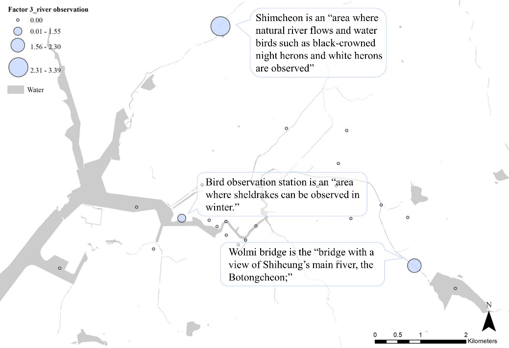
Factor 3 combined areas where the river ecosystem was observable. This includes waterbirds, such as Shimcheon, and the Bird observation station (Figure 5). It allows for the identification of essential places to observe, educate, and manage the various river creatures.
Factor 4 included areas that are habitats creatures living in tidal flat ecosystems, including the “milky fiddler crab habitat” and the “Wolgot tidal flat” (Figure 6). These results make it possible to identify key places where tidal-flat ecosystems can be identified.
Factor 5 combined areas related to puddles between rice fields; this included the Geumidong puddleand Hajungdong puddle (Figure 7). It was possible to confirm the location of Dumbung, which performs an essential ecological function among agricultural fields. Based on this location, Dumbumg management plan could be made.
Factor 6 combined all ecological resources related to reservoirs, including Naebagaji, the Beombae mountain fishery, and the Mulwang reservoir (Figure 8). By identifying the location and sphere of influence of major reservoirs, the spatial scope of the reservoir management plan could be determined.

The analysis of ecological resources shows that the features of Hojobeol’s ecosystem were organized with an emphasis on water. To identify areas where the ecosystem features manifest, maps were created based on the values of the target area factors (Figure 3 to 8). The result was that the tidal flat habitat (Factor 4) was located in the sea; halophyte (Factor 2) and view (Factor1) were located in the middle reaches of the river; puddle (Factor 5) and reservoir (Factor 6) were located in inland areas; and river observation (Factor 3) included sites from where the river could be well observed. All these were identified as excellent ecological resources. In addition, the reservoir (Factor 6) was an area close to the river while the puddle (Factor 5) was far from the river. Thus, it was possible to visualize the ecological knowledge that varied based on geographical features. This perspective made it possible to collect ecological information about the river. Subsequently, it indicated the necessity to formulate environmental plans to strengthen these characteristics.
Discussion
The ecological knowledge of local residents can provide insights on the small-scale ecological operational principles that are unfamiliar to experts. Thus, by organizing this ecological knowledge, it is possible to create a plan that expresses the true ecological features of an area (Teixeira, Martins et al., 2013). This study systematically organized the ecological knowledge of residents of the Hojobeol area in Shiheung City and created a map using the text mining technique. This map represents the ecological features as: coastal tidal flats, halophytes in a middle zone, areas from which to observe the river, bridges with a good view, and puddles and reservoirs in farmland areas. These results were compared with environmental policies to find ways to reveal the features of the tidal flats in the coastal area of Hojobeol, and strengthen the puddles and reservoirs of inland rice fields. Prior to this step, an environmental spatial plan should be presented that describes the features of sites from which to observe the river, areas with good views, and areas where halophytes grow. Such a spatial plan takes the ecological context into account and will strengthen its benefits for local residents. It can also be used for educational contents and routes development for ecotourism and eco-education (Figure 9).

This study confirms the plotting of quantified values of ecological knowledge on a map (Anuchiracheeva, Demaine et al., 2003; Bethel, Brien et al., 2014; Close and Hall, 2006) despite the small number of participating residents. Further elaboration and standardization are required before our results can be utilized as objective data (Usher, 2000). In the future, the traditional ecological knowledge of local residents should be organized systematically to express the ecological characteristics of an area (Pitt, Baldwin et al., 2012), reduce the knowledge gap between the researchers and locals (Knapp, Fernandez-Gimenez et al., 2011), and, hopefully, develop various techniques that can aid in modern environmental spatial planning.
Conclusion
The ecological knowledge, of the local residents, of an area is valuable information that includes wise ecological operating principles. Therefore, it can be highly effective when used in environmental policy making or planning. In this study, we used spatial text mining, a powerful tool for organizing ecological knowledge, to organize ecological knowledge onto a map. It was applied to the Woopo Swamp in Shiheung, through which the ecological knowledge of local residents regarding the aquatic ecosystems ranging from tidal flats to rice fields were visualized. The results thereof were used in the discussion on the directions for environmental planning in the area. This ecological knowledge map can contribute to environmental spatial planning based on the functions of microscopic ecological resources by visually conveying the knowledge of local residents. Furthermore, local governments can contribute to conserving ecological resources through ecological knowledge guidance, discovering eco-tourism themes, and designing outdoor eco-education sites. Through this, adults can confirm the excellence of the local environment, and children can use it to learn the mysteries of nature. Although, this study was limited to ecological knowledge collected from an environmental organization in one area, this can be expanded by initiating a public discussion forum on more common ecological knowledge and standardizing a process to systematically visualize traditional ecological knowledge on maps.
Author Contributions
Jae-hyuck Lee is the sole author of the paper.
Ethics Declaration
The author declares that they have no conflicts of interest regarding the publication of the paper.
Acknowledgments
This work was funded by the Korea Environment Institute as “Conflict mapping to improve residents' acceptability for planned estates of renewable energy (RE2021-02).”
References
- Anadón , J. D., Giménez, A., et al. (2009). "Evaluation of Local Ecological Knowledge as a Method for Collecting Extensive Data on Animal Abundance". Conservation biology, 23(3), 617-625. doi: https://doi.org/10.1111/j.1523-1739.2008.01145.x.
- Anuchiracheeva, S., Demaine, H., et al. (2003). "Systematizing Local Knowledge Using Gis: Fisheries Management in Bang Saphan Bay, Thailand". Ocean Coastal Management, 46(11-12), 1049-1068. doi: https://doi.org/10.1016/j.ocecoaman.2004.01.001.
- Aswani, S. and Lauer, M. (2006). "Benthic Mapping Using Local Aerial Photo Interpretation and Resident Taxa Inventories for Designing Marine Protected Areas". Environmental Conservation, 33(3), 263-273. doi: https://doi.org/10.1017/S0376892906003183.
- Berkes, F. (1999). Sacred Ecology: Traditional Ecological Knowledge and Resourcemanagement. Taylor & Francis, Philadelphia.
- Bethel , M. B., Brien , L. F., et al. (2014). "Sci-Tek: A Gis-Based Multidisciplinary Method for Incorporating Traditional Ecological Knowledge into Louisiana's Coastal Restoration Decision-Making Processes". Journal of Coastal Research, 30(5), 1081-1099. doi: https://doi.org/10.2112/JCOASTRES-D-13-00214.1.
- Chalmers, N. and Fabricius, C. (2007). "Expert and Generalist Local Knowledge About Land-Cover Change on South Africa’s Wild Coast: Can Local Ecological Knowledge Add Value to Science?". Ecology Society, 12(1).
- Close, C. and Hall , G. B. (2006). "A Gis-Based Protocol for the Collection and Use of Local Knowledge in Fisheries Management Planning". Journal of environmental management, 78(4), 341-352. doi: https://doi.org/10.1016/j.jenvman.2005.04.027.
- Doerfel , M. L. and Barnett , G. A. (1999). "A Semantic Network Analysis of the International Communication Association". Human communication research, 25(4), 589-603. doi: https://doi.org/10.1111/j.1468-2958.1999.tb00463.x.
- Drieger, P. (2013). "Semantic Network Analysis as a Method for Visual Text Analytics". Procedia-social behavioral sciences, 79, 4-17. doi: https://doi.org/10.1016/j.sbspro.2013.05.053.
- Görg, C. and Rauschmayer, F. (2012). "Multi-Level Governance and the Politics of Scale: The Challenge of the Millennium Ecosystem Assessment". In Lipschutz, K. a. (Ed.), Environmental Governance (pp. 95-113). Routledge, London.
- Hearst, M. (2003). "What Is Text Mining". SIMS, UC Berkeley, 5.
- Kimmerer , R. W. (2002). "Weaving Traditional Ecological Knowledge into Biological Education: A Call to Action". BioScience, 52(5), 432-438. doi: https://doi.org/10.1641/0006-3568(2002)052[0432:WTEKIB]2.0.CO;2.
- Knapp , C. N., Fernandez-Gimenez, M., et al. (2011). "Using Participatory Workshops to Integrate State-and-Transition Models Created with Local Knowledge and Ecological Data". Rangeland Ecology Management, 64(2), 158-170. doi: https://doi.org/10.2111/REM-D-10-00047.1.
- Lee, J.-h. (2021). "Setting the Governance of a Participatory Ecosystem Service Assessment Based on Text Mining the Language of Stakeholders’ Opinions". Journal of environmental management, 284, 112003. doi: https://doi.org/10.1016/j.jenvman.2021.112003.
- Lee, J.-h. and Kim, D.-k. (2020). "Mapping Environmental Conflicts Using Spatial Text Mining". Land, 9(9), 287. doi: https://doi.org/10.3390/land9090287.
- Lee, J.-h., Park, H.-j., et al. (2020). "Analysis of Cultural Ecosystem Services Using Text Mining of Residents’ Opinions". Ecological Indicators, 115, 106368. doi: https://doi.org/10.1016/j.ecolind.2020.106368.
- Luhn , H. P. (1958). "The Automatic Creation of Literature Abstracts". IBM Journal of research development, 2(2), 159-165. doi: https://doi.org/10.1147/rd.22.0159.
- Mellado, T., Brochier, T., et al. (2014). "Use of Local Knowledge in Marine Protected Area Management". Marine Policy, 44, 390-396. doi: https://doi.org/10.1016/j.marpol.2013.10.004.
- Pert , P. L., Ens , E. J., et al. (2015). "An Online Spatial Database of Australian Indigenous Biocultural Knowledge for Contemporary Natural and Cultural Resource Management". Science of the Total Environment, 534, 110-121. doi: https://doi.org/10.1016/j.scitotenv.2015.01.073.
- Pitt, A. L., Baldwin, R. F., et al. (2012). "The Missing Wetlands: Using Local Ecological Knowledge to Find Cryptic Ecosystems". Biodiversity Conservation, 21(1), 51-63. doi: https://doi.org/10.1007/s10531-011-0160-7.
- Reyes-García, V., Vadez, V., et al. (2006). "Evaluating Indices of Traditional Ecological Knowledge: A Methodological Contribution". Journal of ethnobiology ethnomedicine, 2(1), 1-9. doi: https://doi.org/10.1186/1746-4269-2-21.
- Riechers, M., Barkmann, J., et al. (2016). "Perceptions of Cultural Ecosystem Services from Urban Green". Ecosystem Services, 17, 33-39. doi: https://doi.org/10.1016/j.ecoser.2015.11.007.
- Taminiau, Y., Ferguson, J., et al. (2016). "Instrumental Client Relationship Development among Top-Ranking Service Professionals". The Service Industries Journal, 36(15-16), 789-808. doi: https://doi.org/10.1080/02642069.2016.1272589.
- Teixeira , J. B., Martins , A. S., et al. (2013). "Traditional Ecological Knowledge and the Mapping of Benthic Marine Habitats". Journal of environmental management, 115, 241-250. doi: https://doi.org/10.1016/j.jenvman.2012.11.020.
- Usher, P. (2000). "Traditional Ecological Knowledge in Environmental Assessment and Management". Arctic, 183-193.