Planning Strategies and Design Concepts
Land Use Planning Practices in India:
A systematic review

2023 Volume 11 Issue 3 Pages 1-19
Details
2023 Volume 11 Issue 3 Pages 1-19
Since the beginning of civilisation, humans have used the land. As the population grew, so did the demand for land, which resulted in using land resources, referred to as "land use." In India, land use planning has become essential as land is scarce. Due to fast urbanisation, competition for multiple land uses exists, and severe shifts in land uses have been recorded, necessitating a thorough land-use planning procedure. Therefore, this paper focuses on land use, land-use history at the national (India) and international levels, and the selection of criteria based on the comments and views given by various authors to examine its effectiveness.The research seeks to determine how and to what extent the land use planning process is effective. The work has been executed by listing the four main criteria and various sub-criteria compiled through literature sources. The expert questionnaire survey was conducted and analysed with the help of AHP by calculating the weights of each criterion by using a pairwise comparison matrix to understand the significance level of each criterion for land use planning. Some solutions and dimensions of the land-use allocation process have also been framed. In broader terms, the paper's findings highlight the past and present systems of the land use planning process, its effectiveness, and unachieved goals and provide us with the set of criteria that can act as the basis for the systematic land use planning process in India.
The land is the most essential asset used by humans for their survival and has been in use since the beginning of civilisation. However, with time the use of land for construction purposes, especially in urban areas, has increased (Amin and Fazal, 2017). The land is a unique, precious, and finite resource that cannot be moved. It is also the most fundamental component of survival and is treasured for its richness both above and below ground (Duda, 2017). The population began to increase significantly in the 18th century, so the demand for land increased. And humans have been misusing the land for decades to meet their needs (Roy and Roy, 2010; Wang, Shen et al., 2014).
In the past, land use decisions were made by the individuals themselves. However, over time, things started to change gradually, and both developed and developing nations began to use the land use planning concept. For effectively managing and guiding urban development, land use planning is a commonly used approach (Grover, Tang et al., 2012). Land use planning aims to assess the land's potential and choose the optimum use for it (Nations, 1976). Thus, the concept of land use planning or planning for land uses dates back to when humans first began building for their use (Pickardt and Wehrmann, 2011). By 1000 B.C., the Earth's land use had been transformed. Taking the case from the history of land use planning, the human hunters used the general theory of Land use intensification for their benefit. This theory was first formulated by Ester Boserup, who explained the three phases in the land-use system: productivity (agriculture), population (demography), and infrastructure (transportation). The theory predicts that crises will occur when, despite considering technical factors, the food supply will still not be able to fulfil the growing population's demand. Land-use strategies were adopted due to population increase to accommodate the surge of the migrant population (Ellis, Kaplan et al., 2013). Productivity has decreased in 20% of the Earth's cropland, 16% of its forestland, 19% of its grassland, and 27% of its rangeland (Duda, 2017). Throughout the past 140 years, significant changes in India's land use patterns, such as deforestation, forest alterations, sprawl, etc., have been observed. Since then, environmental hazards have resulted from this gradual shift in land use (Hinz, Sulser et al., 2020). The changes made while allocating land usage for diverse purposes also impact the environment (Ellis, Kaplan et al., 2013). It’s not an easy task for India to have land-use planning for 33 crore hectares (Nukala and Mutz, 2015).
Allocating uses to a piece of land is critical to land use planning. The structure of a town or city depends on how it is planned, but the problem is rapid population growth in the cities and towns, leading to chaos in the areas. Uncontrolled development results in inefficient land use planning due to rapid population growth, increased pressures on ecological carrying capacity, and the need for an effective planning (Santoso, Aulia et al., 2022). To achieve systematic land use planning in India, it is critical to have a planning system suited to each local context (Mashima and Kawakami, 2014). Understanding land use typologies, the history of the land use decisions, the reasons for selecting a particular land use (criteria), the appropriate method to assign relative weights to each criterion, and the lag or gap that needs to be addressed while allocating the land uses, are all essential for effective land use planning.
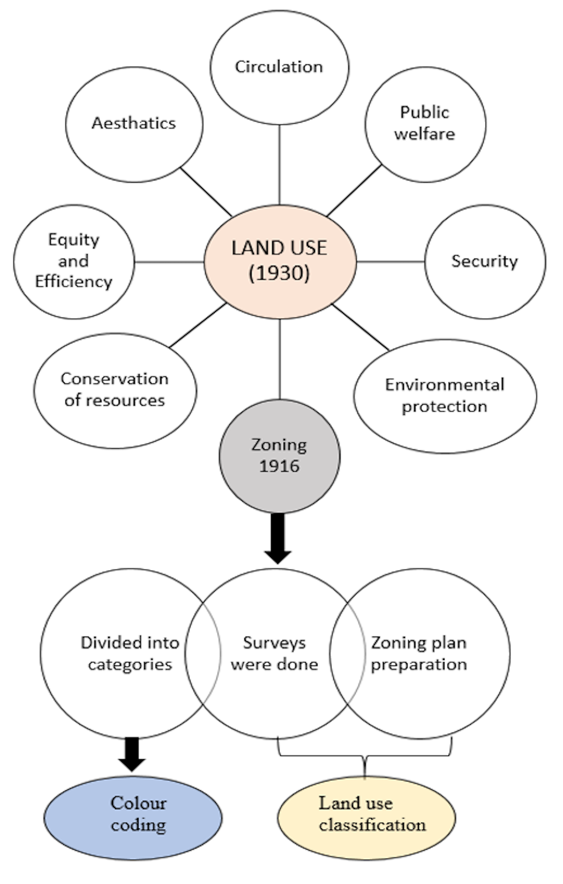
Land use planning has its roots in American planning history. The rural county planning of the 1930s gave rise to the phrase "land use planning" (Akimoto, 2009). It is a common term used in planning and is known to all planners, but still, its actual meaning is uncertain and still growing uncertain with time (Guttenberg, A. Z., 2007). Land-use planning is significant, but the terminology and clarification are vague. There is a need for a common language for planners to make planning successful and efficient (Akimoto, 2009). Land use planning emphasises different elements of urban development, including circulation, public welfare, security, environmental protection, beauty, conservation of resources, efficiency, and equity.
The "intent or aim" for which a piece of land is being used is referred to as the "land use" (Goldewijk and Ramankutty, 2009). On the other hand, land-use planning entails allocating land to an area for various purposes while balancing economic, social, and environmental benefits. Effective land-use planning directs how land-use activities should be carried out while encouraging interconnections among the diverse uses (Resources: Management and Conservation Service, 1993). It is beneficial to allot new land uses to a region or re-allocate current land uses. Providing a specific use for a piece of property is complicated, and specific criteria must be met (Aerts, Van Herwijnen et al., 2005).
Likewise, zoning is one of the most critical aspects of land use planning. Planners utilise zoning to deal with the varied land uses and land development (physical form). Zoning was influenced by the introduction of architectural and urban design rules in European towns at the close of the 19th century. Having long-established municipal powers, German and Swedish cities introduced zoning restrictions to the new territory being urbanised around existing city centres around 1875 to manage construction heights and concentrations and avoid traffic issues (Britannica, 2013). Zoning first gained prominence in American metropolitan cities due to municipal planning and was widely employed by city professionals. Various surveys, such as land use surveys, zoning surveys etc., were done on the land uses, and zoning plans were also made during this period, which led to the land classification system (Akimoto, 2009).
Zoning enables the government to control and manage the real estate and land markets to ensure compatible uses. Lot size, mass, height, and floor area ratio requirements are all covered by zoning laws (FAR). The zoning creates the legal framework, outlines permissible land uses, and distinguishes between various land use categories. Also, it prevents the proximity of land uses that are incompatible with one another (The World Bank, 2015).
The land-use classification (at that time, known as zoning) started in 1916 in America and divided American cities into residential, commercial, and unrestricted areas, which is cited as an extraordinary example in the history of physical planning to date. This advancement inspired numerous planning professionals to modify the categories, which led to the preparation of various land-use maps using the colour coding system for further development activities (Guttenberg, A., 2002).
During the 1950s, colour coding became a standard for the preparation of maps and is recommended to planning professionals for land use maps. This colour-coding system is a set of multiple colours that signify different land uses for a specified area. The significance of various colours used in land-use planning is discussed as follows:
• Yellow for residential usage, including town homes and single-family homes.
• Browns are ideal for high-density and multi-family dwellings.
• Reds for retail and industrial applications.
• Purples for usage in industry.
• Blues for public and institutional settings.
• Green spaces for leisure activities.
• Grays for commercial utility (Babu and Nautiyal, 2013).
Traditional land use planning is now termed spatial planning as it talks about physical elements of the land, i.e., the physical design of the spaces, development of towns and cities, improvement of infrastructure etc. The land-use history is divided into three phases to understand how land-use planning evolved and is explained below in Figure 2. The phases of Evolution and development in land use are discussed as follows:

Planning was seen as physical planning and design that used a particular piece of land. It was physical planning, not social or economic planning. Urban design was the priority at this time. The books of this period emphasised aesthetics. The plans prepared at this time also emphasised urban design and aesthetics. Blueprints were made in 1940 and 1950. Physical planning was done based on intuitions or urban form and aesthetics principles. For example, deciding the industrial location was away from residential areas to save the environment and human health. No systematic research was conducted on the planning of land uses. It was simply an extension of the built-up areas that existed at the time. There was a lack of public participation in the planning practices as the residents living in an area to be planned were not even asked about their views (Taylor, 1998). Somehow, efforts were made by (Alonso, 1964) , such as how to shape land use and integrate it with the infrastructure in the 1900s. Public facility provisions were considered as it was understood they would lead to overall development in the planning.
Various researchers and authors presented their perspectives on land use planning. Some people preferred a dispersed built mass, while others were concerned with aesthetics. There was also a need for flexible land use controls at this time (Pivo, Ellis et al., 1990). Development of an area now necessitates planning permission and falls under the purview of the local government (Airey and Doughty, 2020). Thus, before 1960, i.e., after the second world war, the approach to land use planning was utopian rather than understanding the socio-economic conditions, culture, physical aspects, and so on of a region (Palakodeti, 2020).
To accommodate the new methods and technology in land use planning that emerged in the 1960s, urban and rural land use have experienced several planning interventions (Pickardt and Wehrmann, 2011). As a result, land use planning only became successful after the 1960s. Incorporating social and economic factors into land use planning improved the knowledge (Palakodeti, 2020). An overview of the period representing the land-use evolution over time is represented in Figure 3:

In 1963, transportation was introduced in the land use planning (Palakodeti, 2020). Digital satellite data was available mainly in 1970, and land use classification changed from a demand-driven to a data-driven classification (Comber, 2008). In the 1970s, planning started at the macro level and included the economic-political theory. From the late 1970s onwards, the theories focused more on the issues and problems to be solved rather than theorising the concepts (Taylor, 1998). Various plans were made during the 1970s for land use improvement. Conference on Land Use Information and Classification in Washington D.C., June 28-30, 1971, was done in which James R. Anderson made the two land-use classification systems. The definitions for the land-use categories were also revised (Anderson, 1976). During the 1980s more integrated approach was followed (Pickardt and Wehrmann, 2011) involving experts, decision-makers as well as ordinary citizens (Metternicht, 2017). After 1980, the term "sustainable development" was also used in the land use planning (Palakodeti, 2020). In the 1980s and 1990s, communicative action planning evolved. Initially, during the preparation of the master plan, there was communicative action, but it was not given a high priority. It concentrated on 'how to get things done.' (Taylor, 1998). Thus, the terms and concepts of integrated land-use planning, spatial land-use planning, participatory land-use planning, and ecosystem-based land-use planning originated from the 1980s onwards (Metternicht, 2017).
Report of the World Summit on Sustainable Development Johannesburg, South Africa, was held from 26 August- 4 September 2002 and focused on various points for the land use planning (United Nations, 2002). Land policies for growth and poverty reduction by World Bank in 2003 focused on socially desirable land use, land use regulation and zoning, land use rights, taxation and land use, land-use regulations and land use classes (Deininger, K. W., 2003). The report of the United Nations Conference on Sustainable Development, Brazil, was held on 20-22 June 2012 and focused on better land-use planning (United Nations, 2012). The Land Governance Assessment framework by the World Bank in the year 2012 gave Land Governance Indicators (LGI) in which they pointed out the land rights, Decision-making process, land use restricts, efficiency in land use planning process, Land valuation, management of public land, accessibility and cost-effectiveness etc. (Deininger, K., Selod et al., 2012).
An overview of the national scenario of land use processIndia has a land area of 32.8 crore hectares and a population of 1.2 billion (census 2011). According to Nukala and Mutz (2015), India contributes 2.6 per cent of the world's total geographical area. Land relations in rural India have undergone inequality and exploitation since ancient times (Bandyopadhyay, 1993). The planning of Indian land uses can be classified into the pre- and post-independence eras. Ancient town planning, mediaeval town planning, early town planning, and colonial town planning comprise the pre-independence period. While modern urban planning has been practised since independence,
In Indian history, a significant development in physical planning occurred in the British era (Saini, Sharma et al., 2022). Although the British ruled India for their benefit, they also tried to resolve internal issues of urban governance, such as control of space, provision of water, sewerage, roads, street lighting and other infrastructure (Sharma, Saini et al., 2022). Britishers won the Battle of Plassey in 1757. Thus trade of the English East India Company increased in colonial port cities of India, and three major cities were developed, i.e., Madras (Chennai) in 1644, Bombay (Mumbai) in 1661 and Calcutta (Kolkata) in 1690 (Spodek, 2013). This led to the land use planning of these three cities. The layout of these cities differed from the other Indian cities as the British government subdivided these cities or towns into two categories, i.e. “White Town” and “Black Town”, respectively. “Black Town” refers to Native or Black Town (Indian Citizens).
The basis of the spatial distribution of land was nationality and race. With the introduction of the railway by Britishers in 1853, a sound network system was established between the countryside, where the material was sourced. The rich Indians made houses and owned land for themselves. After the revolt of 1857, the British made new urban spaces called the "civil lines" and covered them with agricultural fields for protection. For their ease, these had broad streets, bungalows set amidst extensive gardens, barracks, parade grounds and churches (NCERT, 2022). Ahmedabad Municipal Commission was established in 1856. In 1858, Britishers passed the Improvement in Towns Act (Act 26 of 1850), which contributed to the support of municipal bodies working on urban improvements in cities and towns. By the end of the 1860s, municipal committees inaugurated building activities in towns and cities. The significant role of municipal bodies was to maintain community facilities and services such as water supply, sewerage, drainage, primary education, roads and streets, parks, and playgrounds, etc. Along with these responsibilities, municipal bodies also control and enforce various building bye-laws to carry out certain urban development activities such as the construction of roads, division of land into building plots and enforcement of regulations concerning the use of land and construction of buildings (Spodek, 2013).
To increase their trade and keep a check on commercial activities, they prepared maps by carrying out regular surveys, gathered statistical data and published various reports. The maps provided information regarding the hills, rivers, and vegetation and were also used for tax and defence purposes. In the late nineteenth century, the British began collecting municipal taxes from the people to provide various services such as water, sewage, and other infrastructure. The census was also attempted by the British in 1872. The social life of the people was enhanced in the nineteenth century. The use of horse-drawn carriages and, subsequently, trams and buses helped people work from home, a new experience. New public spaces, such as parks and cinema halls, were created for entertainment and social interaction (NCERT, 2022) . For Britishers between the 1880s and the 1990s, town planning was primarily concerned with constructing iconic structures. There was a lack of professional experts working on the town planning activities. In 1894, various practices used in England were enacted in the Land Acquisition Act of 1894. This act divided land parcels into plots for housing, recreational activities, transportation activities and physical and social infrastructure. After that, the first town planning law was passed in Bombay, i.e., the Bombay Town Planning Act 1915. This act gives various powers to local governments, i.e., to prepare and implement town planning schemes. It permits the authorities for zoning towns and cities, implement building regulations, acquire land for public purposes, and collect funds for local improvements to provide sophisticated development, sanitation, social amenities, and low-cost housing (Spodek, 2013). In 1822, Britishers made regulations for a detailed land survey to collect land revenue and maintain land records. They prepared village maps, field books, khasra and rights records to gather information about the land occupants (Babu and Nautiyal, 2013).
In 1911, the Britishers shifted their capital from Calcutta to Delhi. The inauguration of New Delhi was done in 1931. Two architects, i.e. Edwin Lutyens and Herbert Baker, mainly worked on New Delhi’s town plan (Johnson, 2008). The new capital city faced further expansion of the built-up area due to the drastic increase in population and natural growth. The densities of old and new Delhi differ, i.e., 60% of the population at that time lived in the Old Walled City, which is only 10% of the area of Greater Delhi (King, 2012). In 1947, there was an influx of population in Delhi due to refugees (Puri, 2012). Significant developments took place in New Delhi as they divided the land into various categories, such as Connaught Place for commercial activities, Civil Lines for residential areas, Cantonment for defence, and Fort Area for administrative activities. But the case was not the same for Old Delhi, as it was highly dense and lacked space for expansion.
Necessary steps taken by India for Land Use Planning are shown in Figure 4.

There was a power transfer from the British administration to the Indian government after independence. The significant development which took place after Independence was the preparation and implementation of a master plan for Delhi, which was the first initiative towards the process for the preparation of a guiding document in India (DDA, 1990, 2021, 2041) and alongside planning for Chandigarh city by Le Corbusier (Chandigarh Administration, 2023; Raghavan and Bhardwaj, 2020). The classification system and the standardised definitions in India were first given in 1950. During 1949-1950, the land use classification was a five-fold system. But the five-fold system couldn’t describe agriculture use in India. Also, the states felt it was challenging to collect and display the data as the meanings of the five classifications were not clear, and their definitions were not defined. Therefore, the government of India's technical committee replaced it with a nine-fold classification. The urban land use classification was also performed in India, but it had the disadvantage of including the agriculture category. Urban areas are diverse; therefore, classification must also be diverse (Wentz, Nelson et al., 2008).
In India, zoning was implemented for the first time in Ahmedabad in the 1954-approved development plan. It was based on the Bombay Town Planning Act of 1954, which for the first time, permitted the formulation of a development plan to govern the urban growth (The-World-Bank, 2015). The government established the National Land Use and Conservation Board in 1985 to define a national policy and long-term urban land conservation and development plan. In 1988, India's National Land Use Policy governed land allocation based on land capability, productivity, and national production objectives. In 1999, the Department of Land Resources was established for land-based development activities (Babu and Nautiyal, 2013). For the optimum land use, the Model Guidelines for Urban Land Policy were framed in 2007 (TCPO, 2007). The Digital India Land Record Modernization Plan was established in 2008 to modernise land records through surveys, computerisation, and registration (Government of India, 2023a).
In 2013, Congress passed the Right to Fair Compensation and Transparency in Land Acquisition, Rehabilitation, and Resettlement Act (Government of India, 2013). A pilot land use planning and management project was framed for integrated spatial land use planning in 2015 (Government of India, 2023b).
According to the 7th Schedule of the Indian Constitution, the land is a "state" subject, which means that state governments are responsible for matters such as colonisation, revenue, maintenance of land records, recording of rights, surveying, collecting rents, transferring revenues, and land transfer and alienation. Regional governments formulate their development plans for cities and towns, and the government needs to buy the land it does not own. Town planning schemes are crucial under these circumstances. In a TPS, the government 'pools' land from many private landowners and uses it for new purposes, such as constructing public buildings, roads, and housing. Gujarat is the most successful example of TPS deployment in India since it allows the government to develop the area without having to buy the land while also raising the value of the land through land pooling and redistribution (Teal-India, 2022). Employing this land readjustment method, Gujarat has created Ahmedabad, the state's largest city. It still uses the TP Scheme to develop the peri-urban and outlying parts of the city. Karnataka, Andhra Pradesh, Madhya Pradesh, Chhattisgarh, and Odisha are attempting to use the TP Scheme to expand urban land. Although the TP Scheme has proved effective, it is still not extensively adopted in India as there are various challenges in scaling up the TP Scheme, and there is also potential for improvement (Jain, 2019).
As a result, efforts for land use planning as a planned strategy can be seen in India after independence. Town planning came to India with the establishment of Improvement Trusts, which included planning for various land uses and preparing maps. However, as the cities grew, there was a need for development authorities that could govern and monitor the land use planning process and chart out TP schemes and development plans (Patel, 2020).
The link between land supply and demand, which is influenced by population, economy, and policy, determines the land usage in a city. Future development can be predicted using a specific analytical approach (Han and Lin, 2017). To understand the different criteria, which must be considered when allocating land uses, it is crucial to study the various considerations that affect the planning of land use in a particular area, which are described below by referring to different literature strands:
Land-use allocation decisions are also affected by various means or criteria such as land suitability for development, property rights of the land, selection of site, accessibility, economy etc. (Duncan, 1977).
Land Ownership: Land ownership means who owns a particular piece of land. Therefore, the ownership details must be considered when deciding the land uses (Poulton, 2007).
Land Use suitability: means to allot the land use to which it is most suitable. An example of land suitability is the capability of the soil to be used for a particular land use. Prime soil does not have productive value, so the land holding the prime soil should not be used for agricultural purposes (Jr, 2005). The suitability is determined by the characteristics of a specific parcel of land and the development proposed for that land (Poulton, 2007).
Threshold Analysis: The land capacity to hold a certain amount of population, infrastructure, development etc., considering the obstacles such as topography, availability of natural resources, and transportation connectivity (Poulton, 2007).
Subsurface Conditions: According to Jr (2005), the primary considerations before land-use planning is the attributes of soil, such as plant growth, soil fertility, the permeability of drainage, the depth of bedrock etc., must be looked into.
Surface conditions: Along with the subsurface conditions, the surface conditions, such as elevation, slope, drainage pattern, temperature, topography etc., must be checked, and then the land should be allocated for use (Jr, 2005).
Site Selection: The property's value is essential in selecting a site for a particular land use. Parks, open spaces, lakes, rivers, hillocks, or any scenic beauty increases the property value of a particular land use. Therefore, various factors can impact the value of land use, i.e., social, economic, environmental, natural, and ethical (Jr, 2005).
Human and land use: The relationship between the human race and land use is an essential criterion to be considered before the allocation of land as it helps to keep records, provide people with privileges, and focus on the needs of the people with the land (Resources: Management and Conservation-Service, 1993).
Employment and income opportunities: Land has a monetary value as a natural resource, and urban development can generate income and employment opportunities if conducted strategically (Resources: Management and Conservation Service, 1993).
Access to Land: All land available is not accessible. The land has constraints depending on its location, such as topography, natural disasters, climate etc. In urban planning practices, if a land parcel has accessibility, its value increases (Verheye, Koohafkan et al., 2009).
Biophysical factors: These may benefit or restrict the various land uses (climate, topography, soil, water).
Vulnerability to hazards: Numerous cities are situated in regions that are vulnerable to natural disasters like earthquakes, subsidence, flooding, cyclones, hurricanes, landslides, volcanic eruptions etc., and planning must be done while considering the hazard risk of a specific area to combat future risks (Shayannejad and ANGERABI, 2014).
Transportation: Integration of land use and transportation is essential for the planned growth of a place (Zhang, Zhang et al., 2017).
Cultural context includes local traditions, institutions, values, political aspects etc.
Demographic and economic dynamics may demand some of the services, population influx etc., that can lead to changes in particular land use (e Silva, 2011).
Population density, cost, accessibility, infrastructure (roads, power, communication, etc.), level of industrialisation in various locations, job generation requirements, eco-sensitive regions, tribal regions, historical sites, etc., are a few additional factors that influence LUP in India (Gupta, 2006).
The criteria mentioned above are established based on literature findings. The next step is to determine the basis for selecting specific criteria, conduct data analysis to establish relative weights for each criterion, and identify the most significant criteria to be considered for assigning different land uses to achieve efficient land use planning.
A detailed systematic research and review methodology has opted for the national and international level study of the land use process. The emphasis is on studies that have attempted to tell us about the process and history of land use allocation to understand the past trend of land use and how it evolved and was carried out. For the time frame, the primary focus is after the mid-1900s, when urbanisation started hitting hard. A systematic and transparent way of searching is done; through the Web of Knowledge, SCOPUS, and various government documents have been referred to. The search keywords included land use, allocation, land use planning, literature of India, and international history of land use planning. The study is conducted in urban planning, architecture, geography, and social sciences. The extensive literature review can provide readers with valuable insights into the land-use planning process and land-use history. To understand the Land-use allocation process, first, the land use process and typologies for land use must be understood, the history of Indian and International Land use has been compiled, and various categories and criteria for appropriate land-use allocation have been summed up.
A questionnaire was designed to quantify the percentage influence of the criteria from literature study of journals, books, related studies, and expert comments. Initially, a pilot survey was conducted, and after some changes were made to the questionnaire, twenty professionals in the field of urban planning (town planning officials of north Indian states such as Himachal Pradesh, Jammu, Kashmir, Uttarakhand, Sikkim, Manipal, Meghalaya and Assam) were requested to complete the survey. The pairwise comparison matrix for the criteria was produced for each expert survey, and AHP analysed the findings. Amongst the various tools available for AHP, a web-based application by K.D. Goepel, which can integrate and evaluate findings from different experts, was selected. Therefore, the analysis is made based on the literature and performed through the AHP technique to know the weights of each criterion. These criteria and weights ultimately helped to determine the most preferred criteria for land use planning/allocation by various experts, which will further lead to a systematic and scientific way of land use planning. Experts gave the most weight to physical criteria, followed by social, economic, and institutional criteria. However, AHP results indicated that these variables are essential for land use. AHP is a crucial tool for carrying out the scientific approach to the land use planning process. Based on the study's findings, a literature review of the area is necessary to determine the criteria and sub-criteria. An overview of the entire procedure followed, and the effectiveness of the land use planning process are included in the conclusion.
Based on a systematic review of the land use planning process from history, the analysis is made in terms of efforts made in land use planning. A comparison of the land use process in India and internationally is performed. Also, a list of criteria and sub-criteria for better allocation of land uses is made from the literature study. Finally, analysis is made through a questionnaire survey, pairwise comparison and at last, AHP is performed as it is one of the essential methods for multi-criteria decision making.
By comparing the national and international case scenarios for land use, it is analysed that the international approach to land use considers a variety of land use planning processes, including land suitability, land evaluation, a top-down approach, communicative action etc. These processes were the first steps toward a more effective land-use allocation. The documents of the international level studies give a detailed list of these steps or processes, which were practised in other Western countries but were not considered in India at that time.
The significant advancements in land use planning in India came due to the British. However, with the rapid urban development in India, land use is changing drastically. The methods adopted for land use planning in India, as explained in various documents, are too general to serve the problem of land use. The process followed for land use planning in India has been side-lined from the various plans made for future use, such as the development and master plans, which do not give the details of the process, or the method used to allocate the various land uses. The land uses are generally allocated based on predictions of the economy, society, and technology made by various planners based on their knowledge. It is also difficult to compare the Indian setting regarding the land use process because of a lack of baseline information on land usage. There is a need for a National Land use policy, which would guide as a document for standards and monitor the country’s land use.
The classification of various categories into several classes was initially seen in the late 1800s, but the first classification in India was carried out post-Independence in 1950. Many nations, like the U.K., are implementing standard nomenclature but India is still lagging in achieving a standardised classification.
The 1960s saw significant progress in land use planning nationally and internationally. Before, planning for land use was only performed using intuition or aesthetics. New interventions in the process of planning land use emerged after the 1960s. Before land uses are allocated for a particular use, various criteria need to be considered that are mentioned in international-level reports for countries like Nepal, Bhutan, the United Kingdom, and others. However, India still lacks this transparent land use planning process. To better comprehend the criteria and sub-criteria for land use planning, the information is gathered through the literature provided by various authors in their papers and compiled under four categories of criteria and various sub-criteria, as mentioned in Table 1.
| Criteria | Sub-Criteria |
|---|---|
| Physical | Soil fertility, Slope analysis, transportation network, Availability, Land development, Use, Location, Servicing, topography, contours of the area, land development through mechanisms, vegetation, hazard risk processes of nature, such as air, water, soil, and the vast variety of flora and fauna; together with the aggregate of the physical products of civilization, including the facilities, forms, and spaces created by man, surrounding urban areas; and availability of water sources etc. |
| Social | Population size, government policies, individual, society and the mixture of social, cultural and political associations, activities and characteristics etc. |
| Institutional | Finance, Tenure, Taxation, Market, Political will, Agencies. |
| Economic | Distance from the market, demand for different land uses capital and labour, functions, processes, relationships associated with the production, distribution, and consumption of goods and services etc. |
For land use planning, gathering information about specific criteria and prevalent sub-criteria in that area is essential. The information helps to have a better understanding of land use. e.g., soil fertility criteria (physical category) are for allocating agricultural areas. If the soil is fertile, it's allocated for agricultural use; if it is not, it can be allocated for residential, commercial, etc. In this way, multiple criteria are seen, and information is gathered about them.
Technical analysis is required in land-use planning to choose the best alternatives for land use (Burby, Deyle et al., 2000). Therefore, for the study, the information on sub-criteria was gathered through literature and placed under four main categories of criteria to have managed information on land use. Further, a questionnaire was developed from a literature review of journals, books, related studies, and expert comments to calculate the percentage influence of the criteria. The responses were examined using the analytical hierarchy approach. Firstly, the pilot survey was performed, and after making certain modifications to the questionnaire, twenty experts in the field of urban planning were asked to fill out the survey. The questionnaire consisted of 4 sections in which ranking was done on a scale of 1–9, where 1 represents equal importance, and 9 represents extremely important (as shown in Table 2). The pairwise comparison matrix for each expert survey was created for each criterion, and the results were analysed through AHP.
Theoretical basis of analytic hierarchy processThe Analytical Hierarchy Process (AHP) is used for data analysis to generate relative weights for each criterion after the list of criteria for land use decisions in Table 1 has been finalised. AHP supports the examination of both qualitative and quantitative attributes (Wedley, 1990). As illustrated in Table 2, Saaty's nine-point scales are utilised to translate qualitative criteria into quantitative data (Saaty and Vargas, 2012). Saaty's nine-point scales were adapted from Saaty (1994, 2008).
A powerful instrument for boosting group consensus on decisions is the multi-criteria decision-making (MCDM) procedure (Jiang and Yu, 2013). The Analytical Hierarchy Process commands a broader acceptance, and adoption and results in satisfaction among the popular MCDM methods (Alshehri, 2018). As a result, AHP is used in the current study to rank the criteria weights. The approach additionally computes a consistency ratio (CR) to validate judgement coherence, which must be less than 0.1 to be accepted. Saaty contains the mathematical basis of AHP (Saaty, 1994).
Table 2. A section of the questionnaire was created for the expert survey.
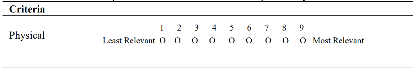
Note: Using a scale from 1 to 9 (where 9 is extremely and 1 is equally important)
AHP-based methodology for the land use planningThe results of this study provide a conceptual framework for assessing the potential of the best-suited land parcel for specific land use. The criteria are selected based on a literature review that can serve as the basis for land use planning in Indian cities. These main criteria have been further broken down into sub-criteria to facilitate understanding and provide a succinct summary of the criteria. With the help of expert opinion and AHP, the most important criteria for allocating land uses are identified.
An overall pair-wise matrix was created to compare each dimension to the other three dimensions to calculate the weight for the criteria, yielding six matrices (Goepel, 2018). By measuring the "consistency ratio" (C.R.), AHP may assess the consensus of experts' opinions, which must be less than 0.10 to be regarded as an acceptable (Saaty and Vargas, 2012). In the current expert survey, CR was determined to ensure survey consistency and the overall CR value for the eligibility criterion was 0.03. The AHP analysis through the expert's opinion survey has identified physical criteria as the suitability criterion with the highest weight of 28.8% to be considered for effective land-use planning, followed by social, economic, and institutional, with weights of 26.4%, 24.3%, and 20.5, respectively, as shown in Figure 5.
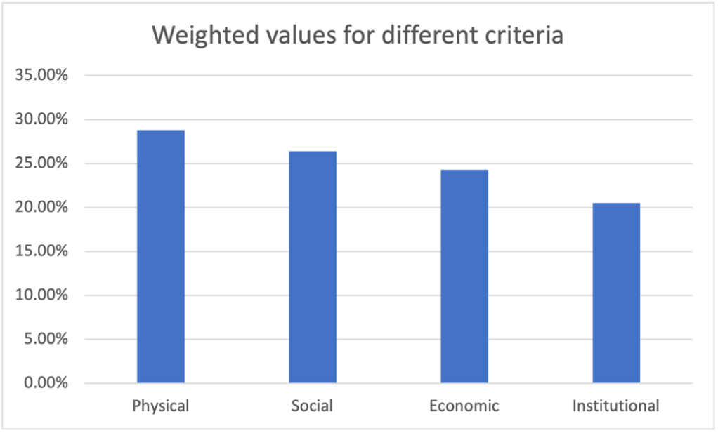
Experts gave the most weight physical criteria, followed by social, economic, and institutional criteria. However, all these criteria were deemed necessary for land-use allocation as per the results of the questionnaire and AHP. Thus, collecting data and information on these criteria is crucial to enhance the land use allocation process.
The study highlights the process of land use planning at the international and national levels. A timeline for the land use planning process is created by focusing on the historical land use patterns from the 1960s. Various criteria and sub-criteria for efficient land use planning have also been summarised. The analysis is conducted in two stages; the first stage compares the land use planning process at national and international levels based on a literature study. The second part of the study identifies criteria and sub-criteria that can guide land use planning. A questionnaire was conducted to identify the weights of the criteria for land use allocation, and the weights of each criterion were determined using a pairwise comparison matrix that AHP analysed.
With the prolonged historical evolution in Urban planning, at both the national and international levels, the term land use and the aspects related to land use planning were underestimated. The terms used in land use planning are unclear, as the definition and typology of land use vary at national and international levels. In some documents, authors use "land use plan," some use it as "land use allocation," and sometimes it is used as "land use zones." The significant finding is that the basis for allocating specific land use to a particular land parcel still needs to be defined.
The problem in the recent era is that Land use changes drastically as the population grows. Thus, there is a requirement for a systematic way of Land use planning as there is no standard way in which land use planning can be practised and shall prove effective. History shows that planning was once practised when its importance was realised, but the methods did not prove beneficial. Furthermore, as times and land use changed, it became critical to have standardised land use categories and a classification system that would make it easy to collect data and have accurate information about land use. Planning needs to be focused on the demands of people, sector demand, land demand, and land use demand for various uses.
Various challenges and inadequacies in the land use allocation procedure result in the cities' unplanned and haphazard development. The requirement is to have a scientific and transparent method of land use planning. As a result, the research establishes a set of criteria and sub-criteria that must be considered before allocating land uses. These criteria guide us through the land-use allocation process and provide the best use for the area. The allocation was then performed based on understanding and analysis. The study also determines the weights of the criteria, indicating that experts gave physical factors the highest weight, followed by social, economic, and institutional criteria. All of these factors, however, were considered essential for land-use allocation, and it is critical to obtain data and information on these criteria to improve the land-use allocation process. A framework for land use planning must be designed to serve as a guide for the land-use allocation process. Land use planning objectives still need to be met. As a result, greater emphasis should be placed on land use planning, and the appropriate allocation of land uses through systematic, transparent, and scientific approaches.
Conceptualization, S. S. and A. K.; methodology, A. K. and B. S.; investigation, A. S. and A. K.; resources, writing—original draft preparation, S. S., A. S.; writing—review and editing, A. K., and B. S. All authors have read and agreed to the published version of the manuscript.
The authors declare that they have no conflicts of interest regarding the publication of the paper.