Abstract
The rural area of the southern slope of the ‘Aurès’ massif represents a significant model of a very particular way of life, which depends not only on the impact of its physical environment, but also on its own culture. That is to say that this rural community seems to be defined according to a dialectical relationship with the society that produced it. In this regard, this paper aims to identify, under the framework of a comparative study, the mode of spatial structuring of a vernacular corpus taken from this rural region. In this case, the village of ‘Beni Ferah’ as a conglomerate of very important traditional settlements, in order to investigate whether there are certain recurrences of spatial syntactic properties at the level of their modes of spatial structuring, i.e. to discover the underlying layouts of the space in question and to bring out, in depth, their socio-spatial structures. The repetition of these structural characteristics is considered as the genotypic index. It is therefore necessary to carry out an analysis process based mainly on the qualitative and quantitative data of the justified graphs of these settlements, in order to highlight the spatial genetic constants that are defined as genotypes. The qualitative analysis of these justified graphs is based on visual factors (distributedness/non-distributedness, symmetry/asymmetry), topological (occupation/movement) and analytical (permeability, segregation/sequencing). While quantitative data is based on mathematical formulas such as Mean Depth (MD), relative asymmetry (RA), integration (RRA), Base difference factor (BDF), control value (CV), and ‘Space Link Ratio’ (SLR). The results obtained revealed a recurrence of the ‘Annere’ plaza intended for the circulation of visitors, in the most integrative position. In second position, the male gathering spaces ‘Djemaa’ (located along the path crossing the mosque which contains a fairly large number of integrated convex spaces), then, the spaces of daily life ‘Thidder’, and of female gatherings (‘T'ssemerth’ and ‘Thessekifth’), being the most segregated and least controlled.
Introduction
Background
Humans have always designed their dwellings, since Antiquity, by referring to several factors related to each other; these factors depend mainly on two fundamental elements: the individual and his physical environment. (Rapoport, 1977) defined this symbiosis as being composed of natural factors (climate, technology, economy, materials, site and landscape...), and socio-cultural factors (basic requirements, intimacy, social relations…), resulting in an architecture that is in harmony with its environment, called ‘vernacular’. It is the image of the society that produced it, due to its originality, which responded to a certain, own logic. In turn, (Bisson, 2007) defined this vernacular architecture as “the traditional and natural means by which communities create their habitat. It is an evolving process requiring constant change and adaptation in response to social and environmental constraints”. Thus, the vernacular heritage, according to the same author (2007), is important because it is “the fundamental expression of the culture of a community, of its relations with its territory and, at the same time, the expression of the diversity culture of the world”.
On the other hand, the heritage of the ‘Aurès’ region represents, for its part, a significant model of a very particular way of life, which depends not only on the impact of its physical environment, but also on its own culture, which gives rise to an original type of architecture called ‘Aurèssian Berber architecture’. If we had to define this Berber architecture in one word, we would say that “it is essentially family, this term meaning both the nuclear family and the tribe” (Golvin, 1989).
Hence, this organization, having a rural character, can be defined both as a spatial and social unit, which means that the space, as a rural entity, is an integral part of the socio-cultural parameters (Côte, 1979). Thus, the organization of urban / rural space takes into account its constituent elements and their interrelationships, and represents, in fact, “the elements which make it possible to situate an object or a person in a given space or in relation to another object or another person” (Ching, 2023).
In view of the above, the question of ‘urban space’ has therefore given rise, since Antiquity, to several approaches in order to give a more precise definition to this notion. The latter, which is considered, according to Bada (2009), as ‘the armature of the city’, is defined as “the ‘void’ between buildings for movement and for outdoor activities such as streets, plazas and parks ; to take in public life in the city” (Bada & Farhi, 2009).
Hence, if we can well define this notion of urban space, as well as its constituent elements, this leads to a better understanding of their modes of spatial structuring by identifying the different types of their spatial organizations, as well as the elements of variation within each type. In this regard, researchers in typo-morphology such as (Caniggia, 1986) have given a clear definition of this notion of ‘type’, which reflects the cultural character of the architectural activity of society; he defines it as “the object seized conceptually via its experience as a cultural fact”. Furthermore, (Noppen, 2008), in his part, also defined the architectural ‘type’ as “a tool, resulting from a rational construction, which makes it possible to decode the structure of a built environment”.
Moreover, (H. Hillier), in their part, give a very clear definition to the notion of space: “space is what we use”, that is to say that, the understanding of space is relative to human use, which enhances the interrelationship between space and human relations. This is why (B. Hillier, 1996) has emphasized, over the last decades (the end of the 1970s and the beginning of the 80s), the need for an analytical theory of architecture and urban planning that is very different from other theories, called ‘space syntax’. It is therefore based on “the principle that urban configuration has an impact on movement, land use, distribution of activities and other social phenomena” (Hacini, Bada, & Pihet, 2022).
This ‘space syntax’ theory makes it possible to “forecast socio-spatial structure or architectural genotype information by developing its computational methods, whereby the special relation between function and social meaning in a building is created by the space.” (Rahmane & Abbaoui, 2021). According to the same author, researchers argue that “as soon as common patterns are identified in integrating different functions or names of dwellings, cultural genotypes that acquire a spatial dimension are treated objectively”. Thus, the ‘genotype’, in architecture, refers to the common laws underlying the physical space of the study area (B. Hillier & Hanson, 1984; H. Hillier), i.e. “the generator process of structuring spaces, which are defined as the physical properties that constitute generic rule subtending the space in question, whereas, the particular physical implementation of these rules constitutes the ‘phenotype’.” (Boutabba, Boutabba, & Mili, 2022).
These two concepts of ‘Space syntax’ contribute, therefore, to understanding the spatial organization and determining the basic laws and rules that govern the production and reproduction of architectural types (Bada & Güney, 2020; Bafna, 2001; Letesson, 2009), the reason why this topic has already aroused the interest of many researchers.
Regarding the research of (SEKKOUR, 2011), the author considers that the appearance of the architectural language specific to the ‘Aurès’ is a consequence of the complexity of its evolution. This led him to study the evolution of this architecture over time in order to identify the causes that led to the genesis of these phenomena. This evolution discussed by the author in this work, explains, therefore, the genetics of the patio ‘Harfifhth’, which is based, not only, on the ‘phenotype’ which is only part of the result of the composition of a set of alleles formed by the ‘genotype’, but also, on highlighting the reasons that induced it.
In the same vein, in another research, (Brown, 2001) conducted a comparative study of the domestic spaces of the three major Berber regions of Algeria (the M'zab, Kabylia and Aurès). This study depends on the various factors by bringing out certain resemblances between the samples of architectural cases, taking the base difference factor as an important parameter that indicates a distinctive pattern for structuring the interior spaces in question. The results reveal that the genotypes of the ‘M'Zab’ dwelling, called ‘Ammas N'Thaddarth’, is relatively shallow, while, the main room in ‘Kabylia’ and in the ‘Aurès’, called the ‘Aali’ (on the first floor), is deep. They also reveal the great importance of the entrance in regulating the interior layout of the domistic space and its depth, which signifies the importance of the separation of the exterior space from the domestic life in these regions.
Furthermore, in the research of (Cunha, 2012), the author studied the spatial organization of middle class apartments in Rio de Janeiro, Brazil, from the1930s until the end of the 20th century. The author aims, in this research, “to investigate if and how different apartment plans could express numerous social changes occurring during that period of time in this context”. The results has allowed “the understanding of more complex social expressions embedded in spaces, a conclusion that wouldn’t have been possible were the genotype characteristics considered as stable aspects along the period of time studied” (Cunha, 2012).
All of this research has studied the different genotype types that characterize the interior domestic spaces using the space syntax, without taking into account the outdoor spaces in the study, it is therefore worth mentioning that there is a lack of urban studies using the space syntax method, in terms of ‘Genotypic study’, especially in the village of ‘Beni Ferah’. Hence, all this would tend to reinforce our interest in this topic, to conduct a comparative study between the different specimens of case studies, which would be considered as a continuity of what has already been achieved, using space syntax methods but from a different point of view.
Research aim
In view of the above, and given that this research aims to determine the basic rules that led to the genesis of spatio-morphological configurations revealing identical socio-spatial structuring modes in all case studies with the same morphological features, our selection was therefore based on the syntactic approach, which aims to understand the links between the physical environment and human behavior in a bipolar relationship. This approach considers that “the urban structure i.e. the street pattern by its configuration is the main guiding feature of people movement/ flows” (Mahfoud, Bada, & Cutini, 2022). This syntactic approach also helps to “explain how the spatial integration of street and road networks affects movement flows, the location of activities and the amount of street life” (Ye & Van Nes, 2013), this is what we would study in this paper by looking for the probable genotypes underlying the physical differences ‘phenotypes’.
Hence, we aim through this present research to try to understand the mode of organizing the constituent spaces of the case studies and their socio-spatial relationships, imposed by well-defined operating rules, in order to highlight the spatial genetic constants defined as genotypes. More precisely, this research aims to investigate whether there are certain recurrences of spatial syntactic properties at the level of their modes of spatial structuring, i.e. to discover the underlying layouts of the space in question and to bring out, in depth, their socio-spatial structures. The repetition of these structural features is considered as the genotypic index, which, consequently, suggests the presence of a cultural pattern, and reflects not only the spatial arrangement of the case studies but also the nature of the socio-cultural patterns that therefore leads to identify the mechanisms that govern the production of these patterns.
Case Study Presentation: Delimitation of The Study Area
Being part of eastern Algeria, the ‘Aurès’ massif brings together the best known set of mountains of the Algerian Saharan Atlas. Four main valleys dissect this ‘Aurès’ massif, and trace the axes of communication there: the valley of ‘Oued EL Abiodh’, of ‘Oued El Arab’ and the valleys of ‘Oued Abdi’ and ‘Oued El Kantara’ whose confluence forms ‘Oued Zarzour’, which passes through ‘Biskra’ to finally join ‘Oued Djedi’ in the Sahara. This gives rise to many villages perched here and there in this ‘Aurès’ area (BARROU, 2019). The vernacular corpus taken from this rural area is the village of ‘Beni Ferah’ as a conglomerate of very important traditional settlements, located on the southern slope of this ‘Aurès’ massif at the level of the ‘Oued El Kantara’ valley, on the left bank (Algeria). Our case study therefore concerns the four main traditional Settlements that make up this village of ‘Beni Ferah’. These four vernacular establishments that we would take as a study corpus to analyze are: the neighborhoods ‘BGHORA’, ‘ASRIR’, ‘ELMEHREB’, and ‘LEKSAR’, which could be represented in (Figure 1).
Given that we are looking for a probable genotype beyond the physical differences ‘phenotypes’, it is necessary to present the spatial properties and the physical characteristics of each of these vernacular establishments, by highlighting the differences between them.
The tool used is the topological reading of their urban tissues, which aims to determine their socio-cultural structural logics revealed in the spatial distribution of these urban spaces. This is carried out by defining each configuration of the study corpus according to its morphological aspects, the structure of its urban units and the main features characterizing the resulting urban tissues, as well as by identifying each urban unit as being a ‘compact cluster’, to determine the different patterns of spatial organization. With the highlighting of the logic of their uses in order to understand their spatial practices and the functional diversity of each constituent space, which are essential for our study.

The reading of each of these different neighbourhoods, represented in (Figure 2), reveals that its tissues are characterized by their perfect integration within the orchards, which form a bioclimatic envelope. It also reveals the formal irregularity of their dwellings, organized in the form of grouping of family houses with patrilineal ties, taking the valley as a regulatory itinerary, thus giving winding streets made up of blocks with a certain linearity resulting from the logic of ‘house/orchard’ coexistence. Taking into account the fact that its path network is veiled, in certain places, by the first floors of the dwellings, which therefore creates a female gathering space during the hot period, called ‘Thessekifth’. This street network of each of these different neighbourhoods is the result of the implantation of the ‘compact clusters’, where the main street meanders around the neighborhood to the religious space that dominates it, in irregular path. The pathways starting on each side of this main street are generally sinuous but wide enough to allow the passage of a loaded mule, and lead finally to a ‘dead-end’ within a ‘compact cluster’ of dwellings to form, consequently, a female gathering space during the cold period, called ‘T’ssemerth’. Each neighborhood has a main access located, either in the lower part facing the national road to access the interior of its tissue, or in part which overlooks the orchards. In view of the above, this spatial organization is characterized by a perfect harmony between the built environment and its natural environment, formed by the stepped houses on the hillside. Hence, the street network service are determined by two directions: one perpendicular to the ‘contour lines’, while the other is parallel to the ‘built environment’, which leads to the ‘culs-de-sac’, delimiting therefore the private space. In reality, the social life within these different neighborhoods takes place at the level of several closely related daily life spaces patterns, according to three hierarchical levels of spaces ranging from public to the most intimate private. namely: commercial spaces, religious spaces (such as the mosque and the mausoleum), as well as social spaces depending on the gender ‘Male/Female gathering spaces’ (called ‘Djemaa’ for men, ‘T'ssemerth’ and ‘Thessekifth’ as being seasonal nomadism spaces for women), in addition to the space where festivals and various seasonal activities, such as wheat threshing; called ‘The Annere plaza’. As the settlements’ sloping site, at the top of the mountain, the religious spaces are located at the higher level of the slope, while those of commerce at a lower level, and between them are the architectural spaces of family life (‘Thidder’ plural of ‘Thedderth’) as well as the exterior urban spaces of social life (‘Djemaa’, ‘T'ssemerth’, ‘Thessekifth’ and ‘Annere’), which would be discussed in detail in the analysis phase.

Methods and Primary Data Collection
In order to be able to answer the inquiry of the present research, questioning the common traits revealing a certain socio-spatial dialectic, or rather, the determining factors in the declaration of genotype/phenotype, which characterize the spatial configurations of the case studies, it is important to find a methodological approach compatible with this perspective. Accordingly, as we seek to confirm or invalidate the existence of a common genotype, which leads to talk of a cultural pattern, this present study involves a methodological approach that expresses the following different phases of our investigation process, which makes it possible to combine, in a logical way, quantitative and qualitative data:
First, the abstraction process into total justified graphs (Qualitative analysis). This analysis process of spatial relations of the case studies to be analysed is carried out by abstracting the spatial arrangements of each neigborhood of the settlement into ‘axial lines’ in the form of an ‘axial map’, in which the urban space will be represented by “fewest and longest straight lines covering all convex spaces” (B. Hillier & Hanson, 1984) that will be generated automatically by using ‘DepthMap©’ software, to facilitate the drawing of their ‘total justified graphs’ using the ‘Agraph3.0©’ software. i.e. each line in the ‘axial map’ is considered as a ‘node’ in a ‘total justified graph’ and for crossing lines “the respective nodes are defined as connected” (B Manum, 2009; Bendik Manum, Rusten, & Benze, 2005).
Then, the extraction process of syntactic properties based on topological types using ‘Agraph3.0 software’ (Quantitative analysis). The abstraction process into ‘total justified graphs’ is a basic initial step to draw the second justified plan graph pattern of each neighbourhood, called ‘Justified graphs by topological types’. These justified graphs by topological types will be analysed quantitatively, by considering syntactic parameters as Mean Depth (MD), relative asymmetry (RA), integration (RRA), Base difference factor (BDF), control value (CV), and ‘Space Link Ratio’ (SLR).
And finally, the comparison and discussion of the results. This final analytical phase aims to identify and extract the genotypes/phenotypes that characterize the spatial arrangements of each neigborhood.
Altogether, merging these space syntax tools/programs for analysing ‘node and connection’ patterns of these different justified graphs, allows producing a ‘connectivity matrix’ and an ‘internal distance matrix’, by respectively detecting the positioning of each node and the internal separation distance of each node from any other node in the graph of each respective neighborhood.
In short, this investigation process is conducted by using the two software: ‘DepthMap©’ to generate the different axial maps of the four neighborhoods, as well as ‘Agraph3.0©’, through which their justified graphs are generated, and the measurements of the quantitative variables are then tabulated by overlapping the results and synthesizing the syntactic properties using ‘Excel©’ software.
Finally this work will follow the phase of interpretation and comparison of the results, or rather the reading of the basic syntactic data, with the consideration of quantitative parameters i.e. the syntactic analysis of the spatial structure and configuration of the settlements that could help to understand socio-cultural behaviours (hierarchy, mobility, separation of female/male space, use/community life), to determine the intensity of the presence of a common genotype, by looking for particular spatial recurrences at the level of these settlements in question, in order to investigate whether there are genotypes or even phenotypes.
It is therefore a question of looking for repetitions of certain structural characteristics that could be found in the organization of these vernacular case studies, which are considered as genotypic indicators. This is carried out by identifying the mode of spatial structuring of the different neighborhoods in question, by defining the comparative syntactic elements, which would be the cause of the similarities and dissimilarities that distinguish them.
We can sum up that the goal is to understand the social logic by studying it through the social practices of the inhabitants/visitors according to their movements, their paths and their obligatory passage points, as well as their topological types, in order to identify the functions of each type and the activities that are regularly linked to it, and which could reflect an understanding of the sociality that reigns there.
Qualitative analysis: Justified graph analysis and the notion of sequencing
The first step of the qualitative analysis of the space syntax consists in making an abstract representation to the architectural plans by justified graphs, with the consideration of two basic properties of representation, namely:
-
・
A continuous boundary with the exterior, so that all other parts of the exterior domain are subject to certain form of control.
-
・
In addition to interior permeability, so that each part of the system is accessible to each other space, without having to go through the outside (Boutabba, 2013; B. Hillier, 1996).
‘Permeability’ of a system is directly related to the integration value of the exterior, i.e. the relative or absolute integration of the overall system from the exterior. Knowing that the lower this value (close to (0)), the closer the exterior is to all the components of the system, the higher the permeability of this system and vice versa.
At the level of this representation of the architectural plans by justified graphs, the spaces are represented by circles which are called ‘nodes’ or ‘cells’ (Preziosi, 1983), and the spatial links of permeability are made by lines between these nodes ‘connection’. If one of the spaces is selected as the root of the graph, the connected spaces will be disposed relative to each other in levels, according to the number of spaces through which it is necessary to pass, to reach each space from the root (Cuisenier, 1991).
Moreover, the notion of sequencing can be apprehended through topological types that (B. Hillier, 1996) illustrates in a clear and obvious way in the justified graphs as follows: the topological type spaces ‘a’ are situated in the final position on the graph ‘dead-end space’, while the spaces of topological type ‘b’ constitute a tree structure where the elimination of one of the links (also qualified as ‘cut links’) “entails the separation of one or more spaces of the system”. As for the spaces of topological type ‘c’, they offer a sub-complex of connections, which implies a ring configuration, and as regards the spaces of the topological type 'c', they are part of a sub-complex of connections, which must contain neither spaces of type ‘a’ nor those of topological type ‘b’. Accordingly, the justified graphs could be divided, according to their degree of ringiness, into tree-like graphs (TG), which are, in turn, divided into three categories, namely: ‘Internal ringy graphs’ (IR) which are characterized by the existence of rings limited only to the interior of the system, without any passage from the outside, The ‘external ringy graphs’ (ER), in which “one or more rings appear which must imperatively pass through the outside”. As for the third category, it is characterized by “the presence of both internal and external rings” by forming ‘Complex ringy graphs’ (CR) (Boutabba et al., 2022).
The justified graphs can also be subject to visual qualification, according to (B. Hillier & Hanson, 1984), through ‘Symmetry/Asymmetry’ relations, as well as ‘distributedness/non-distributedness’ models, which are directly related to the functionality of the system to be analysed. The property of ‘Symmetry/Asymmetry’ “expresses the kinetic-visual depth of various spaces within the spatial system (house layout) in respect to the main space (entrance usually). When the space within house layout has a less depth in relation to other spaces in the system, this means that the space is more symmetric and vice versa”. As for the property of ‘distributedness/non-distributedness’, it “reflects the options of the available ways to access all spaces in the system. By increasing the number of ways of accessing a particular space, its ‘distributedness’ will be increased in the system, this means that the kinetic permeability of the space is in a high level, with a little segregation, or vice versa” (MUSTAFA & HASSAN, 2010).
One of the most important parameters of the space syntax is the qualitative ratio (SLR) ‘Space Link Ratio’, which mainly expresses the choice of the path that a person can take to move from one space to another: SLR = L + 1 / K. Knowing that L: The number of connections; K: The total number of nodes. If this value is equal to (01), it means that it is a tree configuration without alternative routes, while a value greater than (01) means that it is a ‘ringy’ or circuit structure. Which means, in this case, that this value indicates the degree of ‘ringiness’ versus ‘control’ which constitutes another fundamental dimension of syntactic analysis.
Quantitative analysis: Extraction of syntactic properties based on topological types
The ‘space syntax’ also provides quantitative measures, based on mathematical tools and formulas, generated by the ‘Agraph3.0©’ software.
-
・
Total Depth (TD): From a graphic point of view, the Total Depth of a node n, TD(n), is “the total of the shortest distances from node n to the other nodes in the systems, i.e. TD(n) is the total of line n (or column n) in the distance matrix” (Bendik Manum et al., 2005).
-
・
Mean Depth (MD): The depth of a node in a justified graph is “the number of edges in the path from the root node to the chosen node.” Knowing that “the justified graph of a shallow system is bush-like and for a deep system it is tree-like” (Yamu, Van Nes, & Garau, 2021).
-
・
Control Value (CV): The (CV) is a local measure that “allows the assessment of the control force of space for spaces around him or neighboring spaces. If the control value of a space is more than 1, it means that its control factor relatively is strong, but if it is less than 1, it means that its control factor relatively is weak” (Assassi & Bellal, 2016). The Control Value (CV) of node (n) is “the total value received by the node n during this operation” (Rahmane & Abbaoui, 2021).
-
・
The Relative Asymmetry (RA): It is a variable that contributes to understand the integration or the segregation of a space within the justified graphs, by measuring its relative depth, compared to all the others spaces of the system to which it belongs, and therefore by comparing the depth that a system has from a given point, with the depth that it could theoretically reach (H. Hillier) (1987).
-
・
The integration value (i) or Real Relative Asymmetry (RRA): It is a global measurement for all spaces of the system, in order to determine the proportion of integration, i.e. relative centrality of spaces in a system. This value indicates the general degree of integration of each system and that of the connectivity between its spaces. It ranges from 0 to more than 1, the lower this value (close to (0)), the more the spaces that make up the set of each system are connected to each other, the more these spaces tend to be integrated and vice versa. In other words, the higher the connectivity between the spaces, the stronger the integration capacity of each system. It therefore describes “the degree of isolation or depth of a node not only in comparison to its complete set of results but also in comparison with a suitably scaled and idealised benchmark configuration.” (M. J. Ostwald, 2011). Integration equals: i = 1 / RA
-
・
Base difference factor (BDF): It is a measure of the degree of differentiation, between spaces that distinguishes nodes with respect to the values of integration that define them (Hanson & Hillier, 1998; M. Ostwald, 2011). If this value is low (close to 0), this indicates a functional differentiation of the constituent spaces of the system (a strong structure with a minimum of entropy), whereas if this value is high (close to 1), these spaces therefore tend to be homogeneous until there is no longer any difference in configuration between them (indicating maximum entropy).
Syntactic Analysis Results
Qualitative analysis: Abstraction process into total justified graphs
The abstraction of the spatial arrangements of the case studies, which helps to understand the space-generating mechanism of the different specimens, is mainly based on the preliminary readings of their plans, to better understand their social structures through the functions of each space and their intrinsic components. Knowing that the spaces that reveal facts related to the movement and the different activities, will be represented at the level of these justified graphs by gray nodes.
The following figures (Figure 3, Figure 4, Figure 5, Figure 6) show how urban spaces are abstracted in the form of axial lines by constituting an axial map of the urban tissue of each neighborhood, in which each line is considered as a node in a connectivity graph (total justified graph) and for crossing lines the respective nodes are defined as connected. Spatial analysis thus presents the visualization of a mean depth analysis of the axial map (a) of each urban tissue of these neighborhoods via the ‘Depthmap’ software. Their justified graphs (b) are also represented, in these figures, using the main street of each specimen forming the study corpus as the root node (A). Knowing that the ‘main street’ means, in terms of land use, the main entrance area ‘Main access’ responsible for the distribution of movements to various other spaces for each of these different neighborhoods, which was mentioned previously in the case study presentation by referring it to a ‘legend’ figure.
The different figures (Figure 3, Figure 4, Figure 5, Figure 6) show the abstraction process, which mainly aims to prepare the primary basic data for calculating one of the most important ratios of the space syntax: the ‘Space Link Ratio’ (SLR), which represents the choice property, by knowing the respective number of nodes and links that identify the different justified graphs of the four neighborhoods. Moreover, this abstraction process into total justified graphs was in fact only a basic initial step of this syntactic analysis, to draw the second Justified plan graph pattern of each neighbourhoods, called ‘Justified graphs by topological type’.
Quantitative analysis: Extraction of syntactic properties and mobility analysis ‘movement’ based on topological types
Using the "AGRAPH" software, these topological types will be drawn, to which distinct colors will be attributed, so that we can distinguish them. Knowing that nodes of topological type ‘a’ will be represented in blue, of topological type ‘b’ in dark gray, and those of type ‘c’ in white, as well as those of topological type ‘d’ will be colored in light gray.
It is worth mentioning that the qualitative analysis of these justified graphs is mainly based on visual (distributedness/non-distributedness, symmetry/asymmetry), topological (occupation/movement) and analytical (permeability, segregation/sequencing) factors.
This quantitative analysis is therefore very necessary to refine the qualitative properties by highlighting certain basic syntactic notions, in particular: ‘Asymmetry/symmetry’, which interprets the presence of integration or segregation, and ‘distributedness /non-distributedness’, which refers to the notion of control.
In reality, when we speak of ‘distributedness’, it necessarily invokes the correlations between spaces, by defining the permeability of the system, which reveals the degree of control that is exercised.
The preliminary reading of all of these total justified graphs, presented in (Figure 3, Figure 4, Figure 5, Figure 6), allows deducing two general categories that include all of these graphs.
Category 01: This category, which represents 25% of the study corpus (one case found in all the justified graphs; the case of the specimen ‘ELMEHREB’), is characterized by the presence of several rings, which are limited only to the interior of this specimen, forming therefore an ‘Internal ringy graph (IR)’. Figure 7 presents ‘graphically’ the outcome of the analysis as well as the Justified graph 'graph-image' by topological type of this specimen.
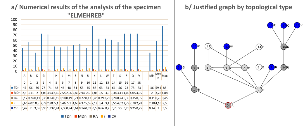
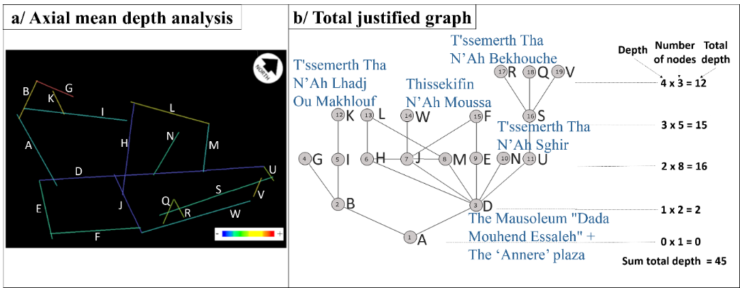
The justified graph of the specimen ‘ELMEHREB’ is characterized by the presence of internal rings, so that Figure 7 shows that the spaces of topological type ‘b’ and ‘d’ stand out locally, revealing a percentage equality of 22.22%, while that of spaces of topological type ‘c’ and ‘a’ represents respectively 16.66% and 38.88% being the result of ten spaces. Figure 3 indicates that this justified graph which is deep (four depth levels), is annular with minimal tree-like branches. This annular character of this type of graph, which mainly favors ‘distributedness’ through a circular itinerary, is therefore characterized by a weak existence of ‘non-distributedness’, which is manifested in spaces of topological type ‘a’ and ‘b’. In addition, it gives the inhabitants greater freedom of movement and circulation due to this ‘distributedness’ of the rings. Hence, this reveals the character of the graph, which represents a strong ‘distributedness’ in its upper part, as well as a determined ‘asymmetry’ in its lower part, represented by a node of topological type "b". In reality, the street (D), which leads to the different spaces of this specimen (including; the mausoleum of ‘Dada Mouhend Essaleh’, as well as the public square ‘Annere’), is the only movement (or rather passage) by which inhabitants/ visitors enter this ‘Annere’ plaza from the main street (A) (main access).
Furthermore, a type space ‘d’, which therefore constitutes the base of the first ring delimiting the most accessible and integrated space, intended for the circulation of visitors (the ‘Annere’ plaza), is characterized by quite significant spatial permeability and flexibility in terms of movements with minimum depth values equal to (2). This first ring gives rise to others, which take support from its constituent spaces, which are at the same level of depth: (H) and (M) of topological type ‘d’. The latter, on the other hand, group together the spaces intended for the various activities located along the pathways (E), (F) and (L) in a predetermined private internal circulation. from which stand out the rest of the family living spaces ‘Thedderth’, as well as the exterior urban spaces of social life (‘Djemaa’ for men, ‘T'ssemerth’ and ‘Thessekifth’ as being seasonal nomadism spaces for women), the most segregated with maximum depth values, being the most intimate. Figure 7 shows that the control (CV) is generated, either by type spaces ‘b’ (in this case, it is the pathway (S), with the highest value (CV) of ‘3,50’), or by the ‘Annere’ plaza, of topological type ‘c’, which gives rise to the ring with a very high control value of (3,36). In fact, the type spaces ‘b’, in this graph, favor a transitional movement, while those of type ‘c’, which form a ring between them, favor a transitional but constrained movement. On the other hand, the type spaces ‘d’, having much lower control values (0,84) compared to other types ‘b’ and ‘c’, allow multiple directional choices of movement. Thus, the type spaces ‘b’ and ‘c’ are characterized by higher control values than those of topological types ‘a’ and ‘d’. knowing that the spaces of type ‘a’: in particular the pathways (K), (W) and (N), leading to ‘T'ssemerth Tha N'Ah Lhadj Ou Makhlouf’, ‘Thessekifth N'Ah Moussa’, and the ‘T'ssemerth Tha N'Ah Sghir’, have minimum values of (0,5), (0,20) and (0,14) respectively, in addition to (R) and (Q), which lead to ‘T'ssemerth Tha N'Ah Bekhouche’, have the same control value (0,25). So that this pattern of social spaces, considered as private spaces, either they do not allow any transition movement, or they authorize many choices of circulation, provided that they are constrained.
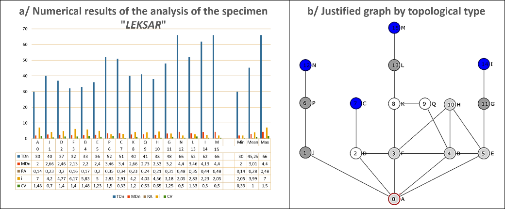
Category 02: This category, which represents 75% of the corpus, is characterized by the existence of both internal and external rings, by forming therefore a ‘Complex ringy graph (CR)’, as shown in Figure 4, Figure 5 and Figure 6.
The justified graphs of the specimens of this category (‘BGHORA’, ‘LEKSAR’ and ‘ASRIR’) represent a tree-like graph (TG) with a very limited number of linear or arboreal branches. These graphs are characterized by a significant level of depth: five levels for ‘BGHORA’ (Figure 6), four for ‘LEKSAR’ (Figure 5), and finally three levels for ‘ASRIR’ (Figure 4). In this category, the ‘distributedness’ is quite high through the large number of rings present in all the graphs, which generates a circular path in most of these justified graphs.
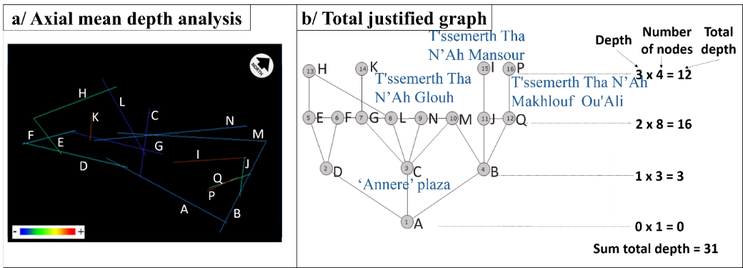
Figure 8 shows that the justified graph of the specimen ‘ASRIR’ (with an equal percentage of 20% spaces of topological types ‘c’ and types ‘a’, in addition to 60% spaces of types ‘d’), although it contains both internal and external rings, there is a retrograde itinerary that requires inhabitants to come back in order to get out of it. In this neighborhood, the street (C), which leads to the most accessible and connected spaces in this specimen, is the most integrated space: the ‘Annere’ plaza (with a low RA value of (0,16) and the highest control value of (1,50)). While the pathways (I), (P) and (K) leading to the most intimate spaces of topological types ‘a’ (‘Thessekifth N'Ah Mansour’ and the two ‘T'ssemerth Tha N'Ah Makhlouf Ou'Ali’ and ‘Tha N'Ah Glouh’) are the least accessible and the most segregated (with the lowest control value of (0,33), (0,25) respectively, and the highest RA value (0,40) and (0,34) respectively).
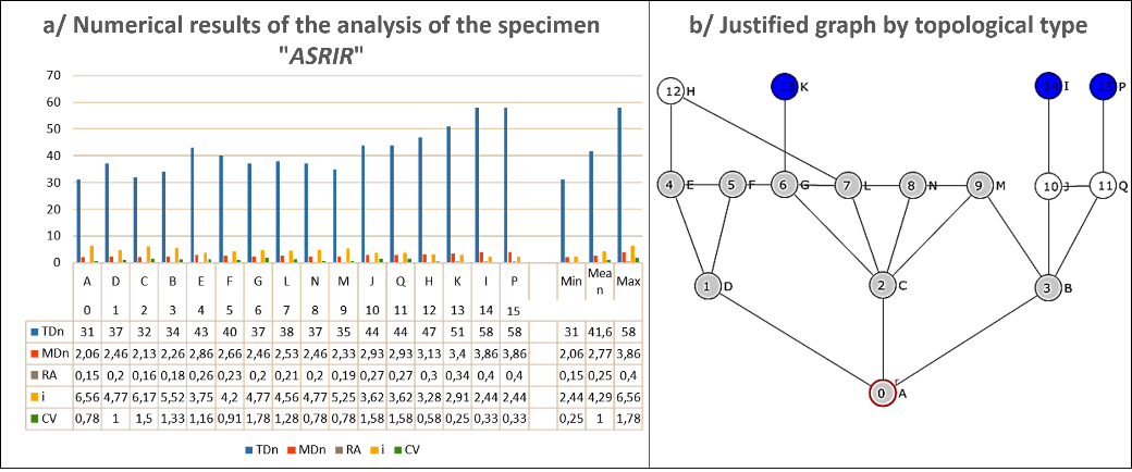
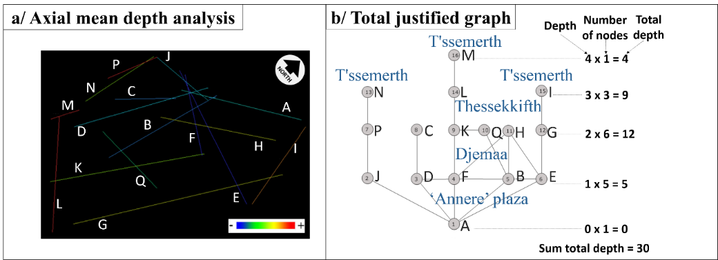
Figure 9 indicates that the justified graph of the neighbourhood ‘LEKSAR’, having 26,66% of topological type spaces ‘a’, ‘b’ and ‘d’ against 20% of type spaces ‘c’, is characterized by a ‘distributedness’ remarkable but remains, globally, asymmetrical due to the presence of small tree-like branches. The latter represent the most intimate spaces (N), (M) and (I), that is to say the profoundest (with maximum (MD) values of (4,40), (4,40) and (4,13) respectively) and the most segregated (with lowest control values of (0,50) and (0,33), and highest RA values of (0,48), (0,48) and (0,44) respectively). In this graph, the two streets (F) and (B) of topological type ‘d’, which form an external ring from which the other rings start, and which define the distribution field towards its different spaces, are the most accessible and the most connected. These axes are therefore the most integrated and shallowest (with minimum RA values of (0,16) and (0,17) respectively, and maximum control values of (1,40) and (1,48) respectively).
As for the justified graph of the specimen ‘BGHORA’, having 21,73% of type spaces ‘a’, 26,08% of types ‘b’, 17,39% of types ‘c’, and 34,78% of topological types ‘d’, as shown in Figure 10, it is marked by a fairly large ‘distributedness’ but remains, globally, asymmetrical due to the presence of small tree-like branches.
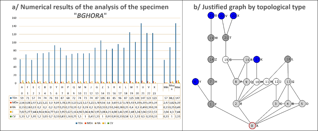
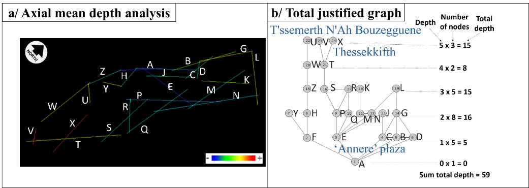
In this graph, the distribution axis (E) of topological type ‘d’, which forms an external ring from which the other rings start, is the most accessible with a large number of connections. This axis starting from the main street (A), which leads to the space of different activities (the ‘Annere’ Plaza), is therefore the most integrated and shallowest (with a lowest RA value of (0,13), and a very high control value of (1,95)). Conversely, the most segregated pathway (X), which leads to the type spaces ‘a’ ‘Thessekkifth’ (With the lowest control value of (0,33), and the very high RA of (0,39)), in addition to the dead-end spaces (the two ‘T'ssemerth N'Ah Bouzegguene’ (U) and (V)), which are in enfilade (With the minimum control values of (0,50) and (0,33) respectively, and the highest RA values of (0,49) and (0,39) respectively), are the least accessible and the profoundest. Thus, this graph is characterized by a strong ‘distributedness’ in its right part, as well as a determined ‘asymmetry’ in its left part, represented by a series of nodes of topological type ‘b’.
Comparison and Discussion of Results
The general quantitative considerations taken into account in this analytical phase are; Mean depth, integration value, base difference factor, and potential permeability. We would also take into account an element considered to be of a qualitative order: the ‘Space Link Ratio’, in order to provide a preliminary clarification about potential genotypes.
Table 1. Summary table of the basic syntactic data of all the specimens
| Specimens
|
SLR
|
MD
|
Relative integration of the overall system from the Exterior based on (RA)
|
Absolute integration of the overall system from the Exterior based on RRA
|
Permeable system:
integrated
|
Non-permeable system:
segregated
|
Mean values
With Exterior
|
Mean values Without Exterior
|
| RRA
|
H*
|
RRA
|
H*
|
| ELMEHREB |
1,21 |
3,28 |
0,42 |
1,86 |
|
X |
1,11 |
0,69 |
1,15 |
0,65 |
| ASRIR |
1,5 |
2,79 |
0,38 |
1,55 |
X |
|
0,94 |
0,56 |
1,02 |
0,50 |
| LEKSAR |
1,37 |
3,00 |
0,45 |
1,84 |
|
X |
1,06 |
0,57 |
1,14 |
0,52 |
| BGHORA |
1,41 |
3,80 |
0,46 |
2,30 |
|
X |
1,20 |
0,76 |
1,25 |
0,74 |
| Total in percentage |
25 % |
75 % |
1,07 |
- |
1,14 |
- |
| Mean |
Table 1 clarifies certain basic syntactic notions, namely: ‘Asymmetry/symmetry’, which expresses the presence of integration or segregation, and ‘distributedness /non-distributedness’ by determining the permeability of the system. Accordingly, to carry out this analytical phase (Table 1), therefore targets: the integration of the overall system from the exterior by means of the potential permeability, the mean integration value, the mean depth, the relativized difference factor H* (with and without taking into account the Exterior ‘EXT’), and the ‘Space Link Ratio’ (SLR), summarized in Table 1, in order to show how certain functions are related.
It is noteworthy, by comparing the different integration values of all the specimens summarized in Table 1, that a good percentage of these specimens 75%, constitutes non-permeable systems (completely segregated) with a possible functional autonomy with respect to the exterior, while 25% is relatively permeable (integrated systems).
It is noticeable that the mean integration values of the different specimens, as a whole, are high (with a mean overall integration value of (1,07) if the exterior is included, and (1,14) if it is excluded). Meanwhile, it shows a limited connectivity between their constituent spaces (a low average capacity for integration, i.e. the structures of this corpus tend to be segregated despite the exclusion of exterior). In addition, ‘ASRIR’ is the most integrated specimen, which shows the lowest integration value in its justified graph (High integration capacity) with maximum connections in its system. Whereas ‘BGHORA’ displays the highest integration value, i.e. it reveals only a low average integration capacity with the fewest connections between its spaces.
Concerning the total mean depth value, which helps to understand the mean depth of all the specimens, indicates how close the spaces forming their justified graphs are to the exterior (the degree of closeness), on average. Table 1 shows that the specimen ‘BGHORA’ is the profoundest specimen, with a mean depth of (3,80). Whereas ‘ASRIR’ and ‘LEKSAR’ are the two shallowest specimens, with a mean depth of (2,79) and (3,00) respectively.
As for the relativized or base difference factor H*, which aims to analyze the spatial configuration of systems through asymmetric relativity, by measuring the differences that characterize the nodes according to the integration values that they specify, on their graphs, helps us to better understand their functional potential. Table 1 shows slight differences between the values of H* of the different specimens, with and without taking ‘EXT’ into account. Moreover, all the specimens have values of the base difference factor H*, which tend towards (1), which means that the spaces of these specimens are homogeneous and that there is no difference in configuration, i.e. no function, within these specimens, is more important than others, and certain activities are closely related spatially, where the integration values are very close.
The numerical data of ‘Space Link Ratio’ (SLR) values in Table 1 are greater than (1) (ranging from 1,21 to 1,5), which indicates that the system is provided with more than one traffic alternative, and therefore it offers itineraries in closed circuits.
Table 1 also shows that there are slight differences between the different values of the syntactic parameters with consideration of the exterior ‘EXT’ of the system of each specimen, and their values if the ‘EXT’ is excluded, which indicates that the spatial system of each specimen is strongly focused on the ‘inhabitant/inhabitant’ relationship, and not on the ‘inhabitant/visitor’ relationship. This therefore indicates that the spatial structuring does not allow great freedom of movement for visitors coming from outside the spatial system, so that the transition from one space to another is carried out according the principle of spatial hierarchy (from public to private space under the control of the inhabitants), which reinforces the principle of social cohesion, by giving therefore an impression of intimacy that is manifested through the ‘public/private’ duality as well as the principle of spatial separation, in order to ensure the greatest degree of privacy.
We would now identify the mode of structuring of the different specimens, by apprehending the order of integration of their constituent spaces, i.e. the functions assigned to their spaces. In other words, to investigate whether these specimens share similarities in terms of their modes of spatial structuring, by comparing each constituent space of the specimen with others of the same specimen, according to their degree of integration, and thus obtaining a rank on a scale. If the rank order of the integration values in each specimen is in a consistent order, it signifies the existence of a cultural pattern, considered as a genotype, as mentioned by (Hanson & Hillier, 1998) who defined integration as being “one of the fundamental ways in which houses convey culture through their configurations”.
Table 2. Order of functions integration, with the inclusion of the ‘EXT’
| Specimens
|
Order of integration
|
| ELMEHREB
|
D (0,11) < A (0,15) < U (0,16) < j (0,17) < H=M (0,18) < E (0,20) < N (0,21) < B (0,22) < S (0,23) < F=EXT (0,26) < L=W (0,28) < I (0,32) < G (0,33) < R=Q=V (0,34) < K (0,42) |
| ASRIR
|
A (0,13) < C (0,15) < B (0,16) < M (0,18) < D (0,19) < G=L=N (0,20) < F (0,22) < E=J=Q=EXT (0,25) < H (0,29) < K (0,32) < I=P (0,38) |
| LEKSAR
|
A (0,12) < F=B (0,15) < E (0,18) < D (0,19) < H (0,20) < J (0,21) < K (0,22) < Q (0,23) < EXT (0,25) < G (0,29) < C (0,31) < P (0,32) < L (0,33) < I (0,41) < N=M (0,45) |
| BGHORA
|
A (0,12) < E (0,13) < F=P (0,17) < C=B=Q=N (0,18) < D=M=J (0,19) < EXT (0,21) < S (0,22) < H=G=R (0,23) < L (0,24) < Y (0,26) < T (0,29) < K (0,27) < Z (0,30) < W=V=X (0,38) < U (0,46) |
It is worth mentioning that the examination of the different specimens, one by one, and the comparison of all the numerical data obtained, revealed the presence of an order of integration, which indicates the existence or rather the recurrence of certain dominant types defined by a logic of distribution. i.e. the basic rule of the mode of structuring of the constitutive spaces having common genotypic characteristics, taking into account the fact that the most frequent types represent genotypes.
Table 2 shows that the different specimens are characterized by alternative routes in their configurations. These itineraries are closed and are largely served by the important streets (D) and (A), called ‘Ibrithen’, which lead to the different most accessible and integrated spaces, intended for the circulation of inhabitants/visitors, including; religious spaces, as well as public squares ‘the Annere Plaza’. The latter, which are characterized by fairly large spatial permeability and flexibility in terms of movements, with minimum depth values and maximum control, offer more than one choice of circulation in a closed circuit (one or more rings), which gives users greater freedom of movement and circulation due to the ‘distributedness’ of the rings. Moreover, in the male gathering spaces: the ‘Djemaa’, which favors a movement of transition on condition that it is constrained, the choice of itinerary is constrained with at most a second choice of itinerary which leads, mainly , to the religious spaces ( the mosque / mausoleum), because this pattern of spaces has a close relationship, in terms of function, with the ‘Djemaa’. However, the pathways (the least accessible), called ‘Izoukak’, which lead to the most intimate spaces (segregated, profound, and less controlled) of family life ‘Thedderth’ and female gatherings (‘Thessekifth’ and ‘T'ssemerth’), do not allow any transition movement, and if allowed, it should be restricted.
It is thus important to note the presence of pivots of circulations, which contributes to increase the control of access to other spaces, in addition to the presence also of a spatial hierarchy, from the public to the most intimate private, resulting from the separation of movements from certain nodes.
Hence, Table 2 shows a certain recurrence of the mode of spatial structuring of the different specimens:
-
・
The ‘ELMEHREB’ specimen is exclusively structured around the ‘Annere’ space located along the most integrated and shallowest distribution street (D), having the greatest number of connections and remarkable accessibility, with the lowest RA value and the maximum control.
-
・
As for the remaining specimens, ‘ASRIR’, ‘LEKSAR’, and ‘BGHORA’, they are strictly structured around the most integrated street (A) (with the highest control value), which basically leads to the most accessible space ‘Annere’ having a strong integration capacity. This street (A) and its edges constitute the pivot of the circulation within these specimens, being peripheral streets, which thus reveals a choice of movement with an obligatory return towards the space ‘Annere’ located along this street (A). The latter, gives directly to the most intimate private spaces of family life ‘Thedderth’, and of social life (Male/ Female gatherings; ‘Djemaa’, ‘T'ssemerth’ and ‘Thessekifth’), which are segregated, with the highest (RA) value, i.e. they reveal only a low mean capacity for integration with the fewest connections.
In view of the above, and according to the data shown in Table 2, the obtained genotypes retain, in a stable and constant manner, the main features found in all samples in terms of spatial structuring mode. It reveals a recurrence of the ‘Annere’ plaza intended for the circulation of visitors, in the most integrative position. In second position, the male gathering spaces ‘Djemaa’ (located along the path crossing the mosque which contains a fairly large number of integrated convex spaces), then, the spaces of daily life ‘Thidder’, and of female gatherings (‘T'ssemerth’ and ‘Thessekifth’), being the most segregated and least controlled.
Conclusion and Further Research
The examination of the different case studies constituting the village of ‘Beni Ferah’ as well as the topological reading of their tissues, one by one, revealed identical socio-spatial structuring modes in all cases, with the same morphological features, defined as the genotypic indices. It confirmed therefore that there are common genotypes, spatially deduced by certain elements of significant recurrence, which reveal a social language that underlies spatial organization through repetitive patterns. The obtained genotypes retain, constantly, the main features found in all specimens (neighborhoods) in terms of spatial structuring mode, which, consequently, suggest the presence of a cultural pattern. These genotypes, which reflect not only the spatial arrangement of the case studies but also the nature of the socio-cultural patterns, were determined according to the structural mode, the degree of ringiness, as well as the base difference factor with the taking into account of the inclusion or the exclusion of the exterior.
All of this information has helped to understand these recurrences and therefore identify the mechanisms that govern the production of these types. Hence, the findings of this work revealed a recurrence of the space of seasonal activities and festivities ‘Annere’, in the most integrating position, characterized by fairly large spatial permeability and flexibility in terms of movements, with maximum control due to its nature as a public space. This space located along the most important streets intended for the circulation of inhabitants/visitors, being the pivots of circulations, which contributes to increase the control of access to other spaces, by offering more than one choice of circulation in a closed circuit, which gives users greater freedom of movement and circulation due to the ‘distributedness’ of this space. In second position, the male gathering spaces ‘Djemaa’ (located along the path crossing the religious space, which contains a fairly large number of integrated convex spaces), then, the spaces of family life ‘Thedderth’, and of social life (female gatherings ‘T'ssemerth’ and ‘Thessekifth’). Given that this pattern of intimate spaces favors a movement of transition on condition that it is constrained being the most segregated.
All in all, the generative mechanism or rather the strategy of grouping the spaces constituent of these neighborhoods is characterized by criteria imposed by the physiographic and climatic nature of this rural region of ‘Beni Ferah’, as well as by a very important socio-cultural structure, which strengthens the relationships in an organization enacted by very specific operating rules. It is shown that all the neighborhoods present an introverted spatial configuration with a spatial hierarchy from public to private, in order to define the intimacy of the family, which responds to the social and topological logics attached to the characteristics of the parcel in relation to the whole tissue. In other words, this spatial structuring of juxtaposed units, imposed by the land typology as well as socio-cultural factors, has brought out several patterns of grouping spaces where all the spaces of social life are articulated to ensure the greatest degree of privacy. This showed the compactness of this urban tissue, revealing social cohesion, by giving therefore an impression of intimacy that is manifested through the ‘public/private’ duality as well as the principle of spatial separation according to the gender and the period of land use.
The strategy of grouping the spaces of the different case studies is based not only on the spatial area intended for housing (the family life spaces), but also on other socio-cultural spaces meeting the needs of ‘community life’ (the exterior urban spaces of social life). i.e. this spatial strategy is the product of the local communitys' living culture as well as the social behaviors that characterize this rural Berber community.
In conclusion, this research was limited to trying to understand the mode of structuring the constituent spaces of the case studies in question and their socio-spatial relationships, imposed by well-defined operating rules, in order to highlight the spatial genetic constants defined as genotypes. Knowing that this work did not examine the concept of phenotype over time, which would also be interesting to be carried out in future studies, and could provide more comprehensive knowledge on the socio-spatial structural constants that may be genetically transmitted, stably and constantly, in space and along a given period of time, to reveal the different social changes occurred during that period.
Author Contributions
Conceptualization, D.S. and B.Y.; methodology, D.S. and B.Y.; field investigation, data analysis, D.S.; writing—original draft preparation, D.S. and B.Y.; writing—review and editing, D.S. and B.Y.; supervision, B.Y. All authors have read and agreed to the published version of the manuscript.
Ethics Declaration
The authors declare that they have no conflicts of interest regarding the publication of the paper.
Acknowledgments
This research was supported by the LACOMOFA research laboratory (University Mohamed Khider of Biskra -Algeria-).The authors extend their appreciation to all the members of this research laboratory of the Department of architecture (University of Biskra) for their scientific support. The authors would also like to thank the anonymous reviewers for their constructive comments.
References
- Assassi, A., & Bellal, T. (2016). An applied approach based on the space syntaxe program for decoding the interior spatial constants in traditional dwellings in south of Oued El Abiod in Algeria. International Journal of Spaces and Urban Territory, 101-128.
- Bada, Y., & Farhi, A. (2009). Experiencing urban spaces: Isovists properties and spatial use of plazas. Courrier du Savoir, 101-112.
- Bada, Y., & Güney, Y. (2020). Using the Space Syntax Analysis to Examine the Spatial Configuration of Houses Layouts and Its Transformation over Time in Biskra City. Paper presented at the 3rd International Conference of Contemporary Affairs in Architecture and Urbanism, Alanya.
- Bafna, S. (2001). Geometrical intuitions of genotypes. Paper presented at the Proceedings of the Third International Space Syntax Symposium, Atlanta, USA: Georgia Institute of Technology.
- BARROU, D. (2019). Les établissements humains anciens face à la micro urbanisation: étude des cas de Menaa, Teniet El Abed et Arris dans les Aurès (Algérie). Université Mohamed Khider-Biskra.
- Bisson, M.-F. (2007). Vernaculaire moderne?: vers une compréhension de la notion d'architecture vernaculaire et de ses liens avec la modernité architecturale. Université du Québec à Montréal.
- Boutabba, H. (2013). Spécificités spatiales et logiques sociales d’un nouveau type d’habitat domestique. Université Mohamed Khider–Biskra.
- Boutabba,
H., Boutabba, S.-D., & Mili, M. (2022). Deciphering spatial identity using space syntax analysis: New rural domestic architecture" Diar Charpenti" type, Eastern Hodna, Algeria. International Review for Spatial Planning and Sustainable Development, 10(2), 235-255. doi: https://doi.org/10.14246/irspsd.10.2_235.
- Brown, F. (2001). Comparative analysis of M'zabite and other Berber domestic spaces. Paper presented at the Proceedings 3rd Space Syntax International Symposium Atlanta, 2001.
- Caniggia, G. (1986). La casa e la città dei primi secoli'in Maretto, P. La casa veneziana nella storia della città dalle origini all'Ottocento.
- Ching, F. D. (2023). Architecture: Form, space, and order: John Wiley & Sons.
- Côte, M. (1979). Le produit agricole algérien. L'Espace géographique, 143-152.
- Cuisenier, J. (1991). La maison rustique: logique sociale et composition architecturale: Presses universitaires de France.
- Cunha, V. (2012). Can genotype patterns change over time. Paper presented at the: INTERNATIONAL SPACE SYNTAX SYMPOSIUM.
- Golvin, L. (1989). Architecture berbère. Encyclopédie berbère(6), 865-877.
- Hacini, C. E., Bada, Y., & Pihet, C. (2022). The mobility of people with disability: Between urban accessibility and urban attractiveness. A case study from algiers, Algeria. International Review for Spatial Planning and Sustainable Development, 10(2), 38-57. doi: https://doi.org/10.14246/irspsd.10.2_38.
- Hanson, J., & Hillier, B. (1998). Tradition and change in the English house. Decoding Homes and Houses; Cambridge University Press: Cambridge, UK, 56-78.
- Hillier, B. (1996). Space is the machine, part four: theorethical synthesis. Space is the Machine: a Configurational Theory of Architecture, Space Syntax, Press Syndicate of the University of Cambridge, 287-343.
- Hillier, B., & Hanson, J. (1984). The social logic of space. Cambridge: Press Syndicate of the University of Cambridge.
- Hillier, H. Graham, 1987. Ideas are in Things: An application of the space syntax Method to discovering house genotypes, 363-385.
- Letesson, Q. (2009). Du phénotype au génotype: Analyse de la syntaxe spatiale en architecture minoenne (MMIIIB–MRIB) (Vol. 2): Presses univ. de Louvain.
- Mahfoud, S., Bada, Y., & Cutini, V. (2022). The impact of the urban structure on the public squares uses: a syntactic analysis Case of Bejaia city, Algeria. International Review for Spatial Planning and Sustainable Development, 10(2), 92-110. doi: https://doi.org/10.14246/irspsd.10.2_92.
- Manum, B. (2009). A Graph complementary software for axial-line Analysis, proceeding of the 7th international space syntax symposium. Stockholm, Sweden, 70.
- Manum, B., Rusten, E., & Benze, P. (2005). AGRAPH, software for drawing and calculating space syntax graphs. Paper presented at the Proceedings of the 5th Space Syntax Symposium.
- MUSTAFA, F., & HASSAN, A. (2010). Using Space Syntax analysis in determing level of functional efficiency: a comparative study of traditional and modern house layouts in Erbil city, Iraq. Paper presented at the The 2nd International Seminar on Tropical ECO-Settlements: Green Infrastructure: A Strategy to Sustain Urban Settlements.
- Noppen, L. (2008). Cours VII L’analyse typomorphologique. EUR-8216 Méthodes.
- Ostwald, M. (2011). Questioning the Primacy of Topology over Geometry: A Configurational Analysis of the Rural Houses (1984-2005) of Glenn Murcutt. The Journal of Space Syntax, 2(2), 223-246.
- Ostwald , M. J. (2011). The mathematics of spatial configuration: Revisiting, revising and critiquing justified plan graph theory. Nexus Network Journal, 13, 445-470. doi: https://doi.org/10.1007/s00004-011-0075-3.
- Preziosi, D. (1983). Minoan Architectural Design: Formation and Signification. In: De Gruyter Mouton.
- Rahmane, A., & Abbaoui, M. (2021). The architectural genotype approach in contemporary housing (1995 to 2010): the case study of Setif, Algeria. Engineering, Technology & Applied Science Research, 11(1), 6810-6818. doi: https://doi.org/10.48084/etasr.4006.
- Rapoport, A. (1977). Pour une anthropologie de la maison, éditions Dunod. Paris.
- SEKKOUR, I. (2011). Un système de l'architecture aurèssienne, une étude génétiquo-syntaxique. Université Mohamed Khider Biskra.
- Yamu, C., Van Nes, A., & Garau, C. (2021). Bill Hillier’s legacy: Space syntax—A synopsis of basic concepts, measures, and empirical application. Sustainability, 13(6), 3394. doi: https://doi.org/10.3390/su13063394.
- Ye, Y., & Van Nes, A. (2013). Measuring urban maturation processes in Dutch and Chinese new towns: Combining street network configuration with building density and degree of land use diversification through GIS. The Journal of Space Syntax, 4(1), 18-37.