Abstract
The interaction between high-rise and low-rise buildings in high-density cities can have an impact on the wind environment of surrounding streets and areas. In Hong Kong, a city with a large number of high-rise buildings, there are public open areas between these buildings that are potential sites for public facilities. However, there is a lack of research on the impact of linear or strip-shaped facilities on the wind environment in such areas. This study used computational fluid dynamics (CFD) simulation to analyze the wind environment of two different layouts of a plot in a dense district in the Kowloon Peninsula, with a focus on the impact of linear building blocks on the wind environment of streets between high-rise buildings. Wind speed measurements were taken at twenty-two points, including entrances and exits of residential areas, rest areas, and surrounding streets, based on the velocity ratio as an indicator. The study found that although linear-shaped low-rise buildings can have a minor negative impact on the overall wind environment, their shape can be adjusted to enhance the wind environment and improve the comfort levels. This research provides valuable insights into planning and designing public facilities in high-density cities, especially in Hong Kong, where street wind environment is essential for the comfort and well-being of pedestrians.
Introduction
Climate is a significant factor that plays a crucial role in shaping the characteristics of urban spatial morphology. Architecture, on the other hand, is the result of human ingenuity in adapting to nature (Yandri, Priyarsono et al., 2021), especially in extreme climatic conditions. In recent years, the relationship between urban spatial morphology and climate has emerged as a prominent research topic in urban and rural planning. Researchers have examined the impact of climate on urban form and function (Dursun and Yavas, 2015) as well as the adaptation of urban forms to climatic conditions (Hamin and Gurran, 2009; Pizarro, 2009). Several studies have highlighted the necessity of formulating urban planning strategies that consider the regional climate characteristics and facilitate the development of resilient and sustainable urban environments (Mouada, Zemmouri et al., 2019; Sharifi and Environment, 2019).
With the acceleration of economic development and urbanization, large-scale urban construction and renewal have led to a decline in the quality of the urban environment. Urban heat islands, in particular, have become a major threat to urban security and public health. The main reason is that the increase in building density and the destruction of the natural entropy caused by the large-scale development and construction of the city makes the underlying surface of the city rougher (Guo, A., Yang et al., 2020), resulting in a gradual decrease in the natural wind entering the city. The increase in population has exacerbated the urban heat island effect (Guo, A., Yang et al., 2020; Liu, Huang et al., 2021). Studies have shown that good urban ventilation can promote urban air circulation and reduce air pollution, thereby improving the urban ventilation environment and greatly reducing the intensity of urban heat islands (Hsieh and Huang, 2016; Rajagopalan, Lim et al., 2014). Natural ventilation can alleviate the urban heat island problem, improves the self-purification capacity of the urban environment, improves the comfort of urban residents, and reduces the heating and cooling energy consumption of urban buildings (Gilani and O’Brien, 2021). As an important component of the healthy, livable, and resilient development of a city, the wind environment quality of the community has become an essential issue in controlling and regulating the wind environment of the neighborhood. Therefore, it should be given enough attention in urban planning and architectural design.
The fundamental concept of constructing an urban ventilation system is to effectively organize urban space to facilitate the generation of air circulation channels within the densely populated areas. This study aims to evaluate the effects of proposed linear-shaped developments on wind speeds at a specific site and surrounding streets. Computational Fluid Dynamics (CFD) was used to calculate wind data for two cases, which were then analyzed using inferential statistics. By analyzing and summarizing the collected wind data, this study identifies the impact of the proposed linear building blocks on the microclimate of the surrounding streets. The findings from this study can serve as a reference for urban design and planning strategies in Hong Kong, and contribute to improving pedestrian-level urban ventilation in high-rise, high-density cities.
Literature Review
Ventilation characteristics of high-density cities
High-rise high-density areas refer to high-density urban areas with high-rise buildings as the main architectural form, such as Hong Kong, Singapore, and Manhattan in the United States.
Hong Kong is located on the southeast coast of China. Due to its unique geological conditions, less than 30% of the land is the built-up area (Qin, Lin et al., 2020). At the same time, with the development of the economy, Hong Kong's population has grown from less than 2 million to more than 7 million in the past 70 years. In order to accommodate a huge population on a limited land, Hong Kong has gradually developed into a high-rise, high-density urban environment.
The unique spatial form of high-rise high-density cities determines that its ventilation mode is different from other forms of urban areas (Lau, Chung et al., 2019). In high-rise and high-density areas, the air flow through the tops of buildings on both sides of the street has difficulty sinking and reaching the ground level of the street. In this case, the airflow movement in the street space is weak, and the ground level is even close to a steady wind state. Therefore, regional ventilation relies on urban air ducts formed by open spaces such as street, squares, and green open spaces (Guo, F., Zhu et al., 2017; Ng, 2009). In high-density environments, typically narrow and towering urban street spaces are occluded by high-rise buildings, and pedestrians have very limited access to light, visible sky, and natural ventilation at ground level. Under the situation of rapid urban development, the contradiction between high-rise and high-density construction and improvement of the urban environment is becoming more and more obvious, and the sustainable planning and design of high-density cities has also attracted more attention.
Natural ventilation studies
The relatively in-depth theoretical research on natural ventilation management in urban buildings can be traced back to the entire ancient Roman Empire. Vitruvius, a famous Italian architect, in his "De architectura" compiled in his later years, has begun to deeply consider some natural ventilation management problems and environmental conditions that may exist in urban architectural design, and some solutions have been proposed in an intensified manner (Krohn, 2011). The so-called "feng shui" of ancient Chinese architectural feng shui in scientific and academic theories mainly refers to the collective type formed by the geographical location of the settlement and the natural ventilation and public areas between the settlement sites. Subsequently, "feng shui" was further clearly defined as "local microclimate" (Hong, Song et al., 2007). It can be seen that the importance of natural ventilation has been widely accepted and valued by people in China and the world.
Due to the gradual change in the climate within the global range, great attention is paid to environmental protection and resource consumption in the multi-national and regional areas. In 2006, the research team of the Chinese University of Hong Kong was commissioned by the Hong Kong Planning Department to conduct an overall assessment of the current planning wind environment in Hong Kong. The urban air ducts are designed according to the characteristics of climate and terrain, such as establishing some ventilation corridors, reducing ground coverage, controlling building volume and height, increasing green space and building ventilation, etc (Ng, 2009). In 2008, the Architectural Institute of Japan proposed that the surrounding sea breeze could be used to introduce the ventilation corridors of the city, and led to different utilization modes. For example, the streets and buildings distributed in the city can be arranged in order from high to low, or in a staggered method (Balabel, Faizan et al., 2021).
In addition, many researchers have done a lot of research on building units and building groups, block wind environment, and urban ventilation. Priyadarsini, Rajagopalan et al. studied the wind-guiding effect of buildings on regulating microclimate by using computational fluid dynamics, and concluded that the wind speed can be increased in a street gorge space with a proper aspect ratio (Priyadarsini, Hien et al., 2008). TL Huang et al. used wind tunnel experiments to study the pedestrian wind environment in a street canyon, including the effects of the height and geometry of surrounding buildings and street width on wind direction and speed. Results show that replacing existing low-rise buildings with high-rise buildings could reduce wind speeds and natural ventilation potential in certain surrounding street canyons (Huang, Kuo et al., 2020). In addition, J. A. Akubue investigated the impact of street geometry on the natural ventilation airflow patterns of three different street layouts in Enugu City (Akubue, 2019). J. O. Cheung and C.-H. Liu studied the effect of regular and staggered high-rise buildings with different spacing on natural ventilation (Cheung and Liu, 2011).
Although a large number of studies have investigated ideal building arrays and residential building forms, there is currently little research on the relationship between low-rise public facility building forms and street ventilation in high-density cities. Therefore, the authors have used computational fluid dynamics (CFD) to analyze the relationship between linear public buildings and street ventilation in high-density cities. This study bridges the gap between building form and high-density urban ventilation, and provides a reference for future architectural design and urban planning.
Methodology
Study area
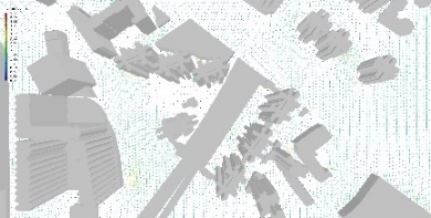
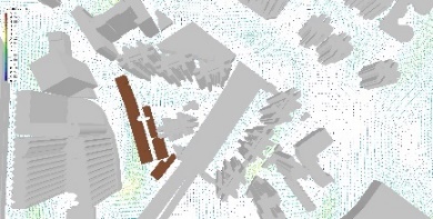
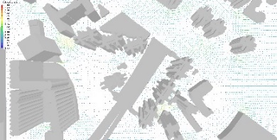
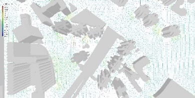
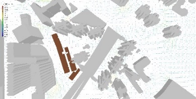
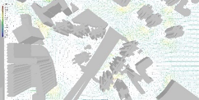
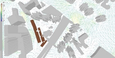
As a case study, the authors have conducted CFD simulations and evaluations in the Hung Hom Area of Kowloon, Hong Kong. Hung Hom is an old district located on the Kowloon Peninsula of Hong Kong. Hung Hom used to be a comprehensive development area with industrial (e.g, the Whampoa Dockyard), commercial, public housing estates and private housing estates. However, with the renewal of the old district accompanied with the large-scale reclamation of the Hung Hom Bay, it has now become a district dominated by residential buildings. The map of the study area is shown in Figure 1.
Models and computational domain
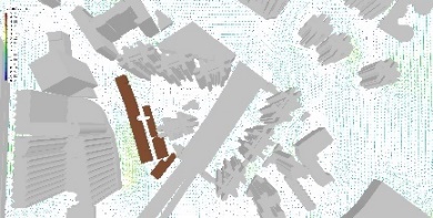
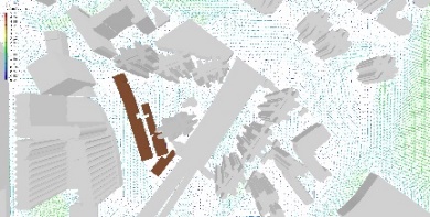
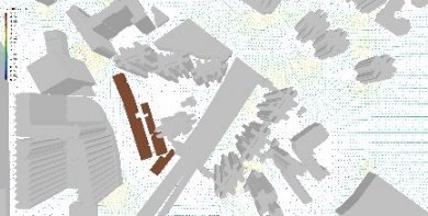
The model is based on the 3D Spatial Data (Series: 3D-BIT00) from Lands D (
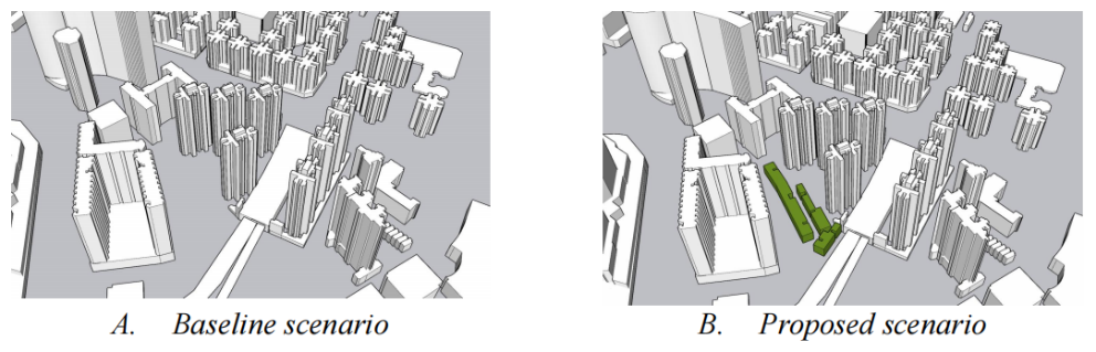
https://www.landsd.gov.hk/en/spatial-data/open-data.html). The proposed new building is a long strip with a height of 10m. Scenarios of both ‘with and without’ the linear-shaped development were investigated. Two design scenarios are introduced as following:
The Technical Circular No. 1/06 – Air Ventilation Assessment (Technical Circular), jointly issued by the Housing, Planning and Land Bureau and Environment, Transport and Works Bureau to address the technical and implementation issues of AVA in Hong Kong. The Technical Circular is followed in this study. Computational Fluid Dynamics (CFD) complying with SST k – ω turbulence modelling, is used for modeling the air ventilation under different prevailing wind directions for baseline and proposed design scenarios. The setting of the CFD calculation conditions will be described in details below.
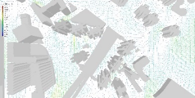
Based on the above Technical Circular No. 1/06, the assessment area and surrounding area should include an area up to the perpendicular distance H and 2H respectively (Ng, 2009). H is the height of the tallest building under study. In this study, the value of H is 108 m. The surrounding area, i.e., modelling area, is 800m x 800m, larger than 2H. The computational domain for both design scenarios in this study are the same: 2200m x 2200m x 300m (W x L x H), as shown in Figure 3.

The technical methods adopted by the existing urban landscape climate research mainly include three types of simulated testing, i.e., wind tunnel investigation, measurement, and computer simulation technology (i.e., CFD technology). Compared with the former two, the biggest advantages of CFD techniques are their short duty cycle, low-cost consumption, and intuitive visualization of simulation results. Therefore, when simulating the wind environment, the application of CFD technology can quickly obtain and analyze more effective atmospheric monitoring data.
The weather data are collected from the weather station and from
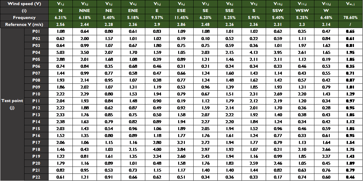
https://climate.onebuilding.org/. The input wind profiles are set based on the data for the annual wind availability. As highlighted in Table 1, the incoming prevailing wind directions are chosen, based on the requirement from Hong Kong Technical circular No. 1/06: “the probability of wind coming from the reduced set of directions should exceed 75% of the time in a typical reference year”. In this research, the total wind probability of the chosen wind directions is 78.6%. The input vertical wind speed profile is set as:
V
h
=
V
met
×
(
h
d
met
)
a
(1)
where a is the surface roughness factor (0.22) (AIJ‐RLB, 2004), and
V
met
is the mean wind speed at infinity (
d
met
= 100 m) above the ground as shown in Table 1.
Table 1. Annual wind availability data in Hong Kong. The chosen wind directions are highlighted.
| Wind Directions (i)
|
Average Velocity at Infinity, m/s
|
Wind Probability (Pi)
|
| 0o (N)
|
2.56 |
6.31% |
| 22.5o(NNE)
|
2.44 |
6.18% |
| 45o(NE)
|
2.28 |
5.4% |
| 67.5o(ENE)
|
2.36 |
5.18% |
| 90o(E)
|
2.9 |
9.57% |
| 112.5o(ESE)
|
2.86 |
11.45% |
| 135o(SE)
|
2.48 |
6.2% |
| 157.5o(SSE)
|
2.26 |
5.25% |
| 180o(S)
|
2.36 |
5.95% |
| 202.5o(SSW)
|
2.31 |
5.4% |
| 225o(SW)
|
2.48 |
4.77% |
| 247.5o(WSW)
|
2.3 |
5.25% |
| 270o(W)
|
2.14 |
6.48% |
| 292.5o(WNW)
|
2.2 |
3.39% |
| 315o(NW)
|
2.33 |
2.98% |
| 337.5o(NNW)
|
2.3 |
2.57% |
Note: 1. Total wind probability of the chosen wind directions: 78.6%.
2. Calm for 7.67% of the time = 672 hours.
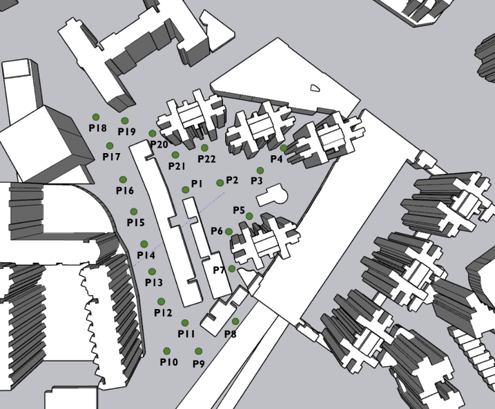
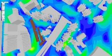
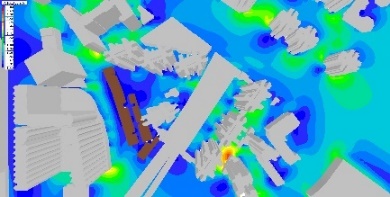
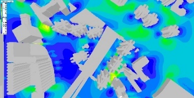
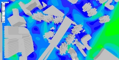
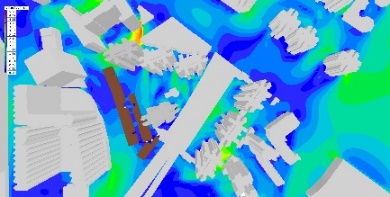
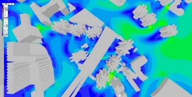
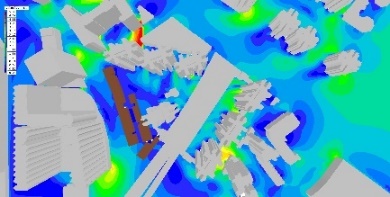
In order to further investigate the wind environment in this area and study the impact of linear building blocks on the street wind environment, the authors used the Phoenics Software to simulate the wind environment at 22 test points. The simulation mainly focuses on the wind environment at a pedestrian height of 2 meters from the ground. This is because the ventilation at this height has a greater impact on human health. The test points are the locations where wind speed and velocity ratios are generated. In this study, the test points are located within the assessment area, which consists of both the project area and the surrounding area. A total of 22 test points is selected at the pedestrian level, as shown in Figure 4. As for Technical Circular No. 1/06, the overall test points are evenly distributed and positioned in the surrounding open areas.
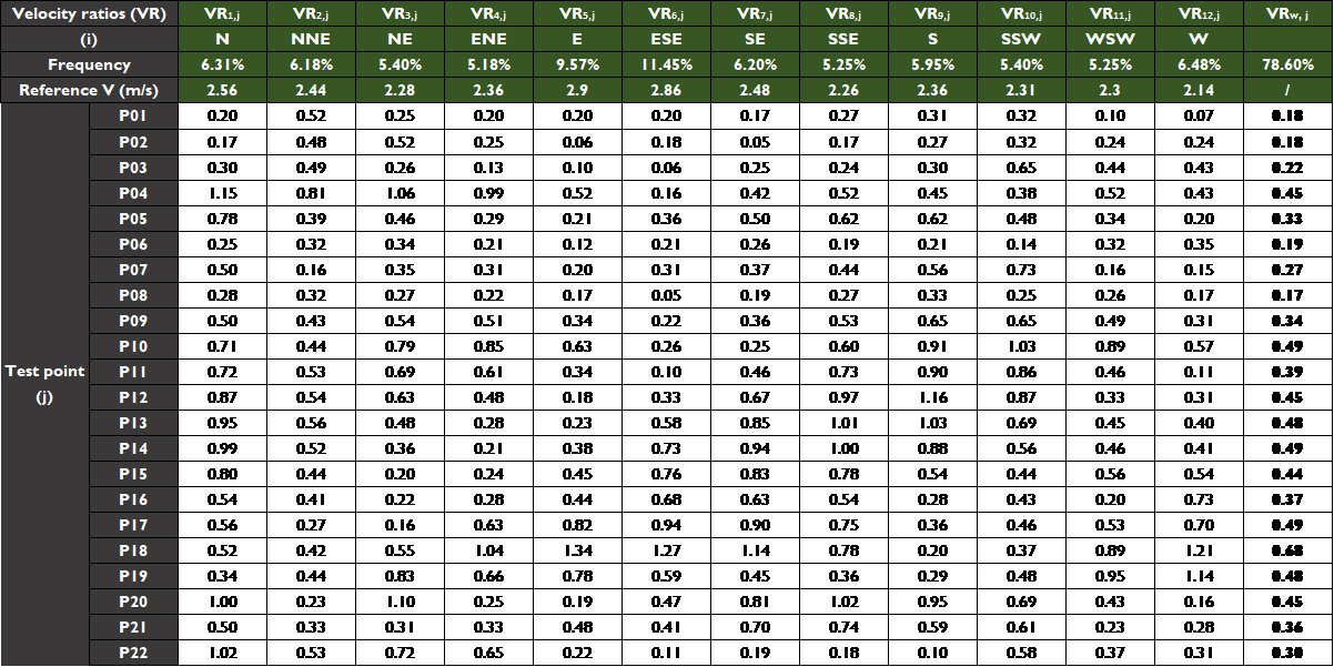
The velocity ratios (VR) were employed in this study to evaluate the wind environment. The wind speed ratio reflects the impact of urban form on ventilation and the wind environment experienced at pedestrian height on the ground. In high-rise and high-density areas, a higher wind speed ratio indicates a lesser impact of construction on urban ventilation. The wind velocity ratio (VR) of the test points for a specific wind direction is calculated as follows:
VR
i
,
j
=
V
i
,
j
V
i
(2)
where 𝑉𝑖,𝑗 is the j-th test point’s wind velocity at pedestrian level (2 m above ground) (Wang, Xu et al., 2018) in a particular wind direction (i), 𝑉𝑖 is the averaged wind velocity at the top of the wind boundary layer, independent of ground roughness, buildings and local site characteristics (Ng, 2009). The overall wind velocity ratio (𝑉𝑅𝑖,) for each test point is calculated as:
VR
w
,
j
=
∑
i
=
1
12
P
i
×
VR
i
,
j
(3)
where Pi is the annual probability of winds reaching the study area from the wind direction(i) (Ren, An et al., 2014). These calculations help to provide insight into the effects of the proposed linear building blocks on the microclimate of surrounding streets, and can serve as a reference for urban design and planning strategies in high-density cities.
Results and Discussion
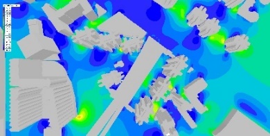
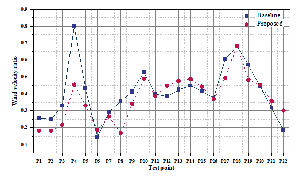
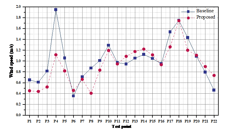
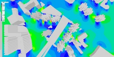
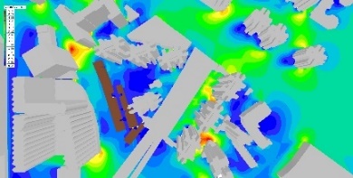
For each of the 12 wind directions, the calculation results of velocity ratios are presented in Appendix A, while the wind speed and vector distribution at a height of 2 meters above the ground are displayed in Appendix B. Additionally, Figure 5 and Figure 6 show the average 𝑉𝑅𝑤, and V𝑤, of each test point for the 12 wind directions at 2 meters above the ground.
For this study, design scenario with higher velocity ratio will be considered superior than those with lower velocity ratio. As shown in Figure 5 and Figure 6, it is obvious that the proposed design scenario has little difference in the performance of outdoor natural ventilation, and the main discrepancy is at Test points #4 (improved) and #8 (worsen but negetiable due to the fact this is an area unpopulated by pedestrian).
The average values of 𝑉𝑅𝑤, in the baseline and proposed scenario are 0.41 and 0.37, respectively. The mean values of Vw,j for the baseline and proposed scenarios are 1.02 m/s and 0.92 m/s, respectively. Combined with the wind speed in Test Point #4, the proposed scenario has alleviated the excessive wind speed. Test Point #8 is located near the nearby viaduct, and there are few pedestrians. Therefore, we proceeded with the rest of the test points while taking out Test Point #4 and #8. In this case, the resultant mean values of 𝑉𝑅𝑤, for the baseline and proposed scenarios are 0.40 and 0.38, respectively. It follows that the average values of Vw,j for the baseline and proposed scenarios are 0.98 m/s and 0.94 m/s, respectively. It could then be concluded that the proposed linear building blocks have a marginal negative effect on the surrounding wind environment.
Meanwhile, comparing and analyzing the specific indicators from two different dimensions, it can be seen that the street wind environment around the proposed linear-shaped low-rise building is affected to different degrees, mainly in the following aspects:
-
1)
The wind speed of P1 to P3 has been affected (reduced velocities) due to the linear building blocks, but at the same time, the strong wind at P4 has been alleviated. The measuring point P4 is located between two high-rise buildings, and the wind speed was higher. When the wind direction is northerly, the resultant wind speed is lowered from 5.03 to 2.95 m/s (Table A1). At P4, the proposed linear-shaped developments has alleviated this phenomenon and reduced the wind speed to a reasonable range.
-
2)
Due to the occlusion of the proposed linear building blocks, the wind environment of P7-P10 is affected (lowered velocities) to a certain extent. Yet since these points are adjunct to the viaduct, there are fewer pedestrians, the negative impact is considered neglible.
-
3)
Comparisons between the two scenarios show that at P12-15, the wind speed at pedestrian height are being increased, still within a comfortable range. This is because the building layout produces a narrow pipe diversion effect of the air flow, forming an unobstructed air duct ventilation, which resulted in an enhanced ventilation efficiency between the new and existing buildings.
Conclusion
In this study, CFD assessment is carried out to assess the effects of proposed linear-shaped developments on wind speeds at a study site and surrounding streets. The simulation results indicate that the proposed scenario has limited negative effect on the surrounding wind environment. Additionally, the study draws several conclusions regarding the relationship between linear building blocks and wind direction, as well as a useful planning and design suggestion for high-density cities.
Specifically, the study found that when linear building blocks are parallel to the wind direction, they have less resistance to the wind and can increase wind speed. When linear building blocks are perpendicular or oblique to the wind direction, the direction and scale of the building can be controlled to increase ventilation between buildings and reduce the area of the windward surface. Moreover, the study highlights the importance of a good street wind environment in Hong Kong's humid and hot climate, particularly in the context of normalized prevention and control of COVID-19.
By simulating different scenarios of existing urban blocks, this study provides insights into the impact of linear building blocks on street wind environments in high-rise and high-density areas. The establishment of a good street wind environment can facilitate the diffusion of urban air pollutants, reduce the urban heat island effect, and ultimately improve the local wind environment in high-rise and high-density cities.
However, it is important to note that the wind environment in high-rise and high-density cities is a complex system influenced by various environmental factors. Therefore, this study only provides a pilot qualitative discussion of urban ventilation and building layout and focuses on a special case for research. Nonetheless, the findings and suggestions presented in this study provide valuable insights for future planning and design of high-density cities.
Author Contributions
Conceptualization, Stephen Siu Yu Lau; methodology, Yijia MIAO; software, Yijia MIAO; data curation, Yijia MIAO; writing—original draft preparation, Yijia MIAO; writing—review and editing, Stephen Siu Yu Lau; supervision, Stephen Siu Yu Lau. All authors have read and agreed to the published version of the manuscript.
Ethics Declaration
The authors declare that they have no conflicts of interest regarding the publication of the paper.
Acknowledgments
Thanks are due to the architectural practice and designer of " P. K. Ng & Associates (HK) Limited " for collaboration with the authors on the respective study. Thanks is also due to Sam CM HUI PhD for his role as advisor.
References
- AIJ‐RLB. (2004). Recommendations for Loads on Buildings. Architecture Institute of Japan Tokyo.
- Akubue , J. A. (2019). "Effects of Street Geometry on Airflow Regimes for Natural Ventilation in Three Different Street Configurations in Enugu City". Different Strategies of Housing Design. IntechOpen.
- Balabel, A., Faizan, M., et al. (2021). "Towards a Computational Fluid Dynamics-Based Fuzzy Logic Controller of the Optimum Windcatcher Internal Design for Efficient Natural Ventilation in Buildings". Mathematical problems in Engineering, 2021, 1-10. doi: https://doi.org/10.1155/2021/9936178.
- Cheung , J. O. and Liu, C.-H. (2011). "Cfd Simulations of Natural Ventilation Behaviour in High-Rise Buildings in Regular and Staggered Arrangements at Various Spacings". Energy and Buildings, 43(5), 1149-1158. doi: https://doi.org/10.1016/j.enbuild.2010.11.024.
- Dursun, D. and Yavas, M. (2015). "Climate-Sensitive Urban Design in Cold Climate Zone: The City of Erzurum, Turkey". International review for spatial planning and sustainable development, 3(1), 17-38. doi: https://doi.org/10.14246/irspsd.3.1_17.
- Gilani, S. and O’ Brien, W. (2021). "Natural Ventilation Usability under Climate Change in Canada and the United States". Building Research & Information, 49(4), 367-386.
- Guo, A., Yang, J., et al. (2020). "Influences of Urban Spatial Form on Urban Heat Island Effects at the Community Level in China". Sustainable cities and society, 53, 101972. doi: https://doi.org/10.1016/j.scs.2019.101972.
- Guo, F., Zhu, P., et al. (2017). "Improving Natural Ventilation Performance in a High-Density Urban District: A Building Morphology Method". Procedia Engineering, 205, 952-958. doi: https://doi.org/10.1016/j.proeng.2017.10.149.
- Hamin , E. M. and Gurran, N. (2009). "Urban Form and Climate Change: Balancing Adaptation and Mitigation in the Us and Australia". Habitat international, 33(3), 238-245. doi: https://doi.org/10.1016/j.habitatint.2008.10.005.
- Hong, S.-K., Song, I.-J., et al. (2007). "Fengshui Theory in Urban Landscape Planning". Urban ecosystems, 10, 221-237. doi: https://doi.org/10.1007/s11252-006-3263-2.
- Hsieh, C.-M. and Huang, H.-C. (2016). "Mitigating Urban Heat Islands: A Method to Identify Potential Wind Corridor for Cooling and Ventilation". Computers, Environment and Urban Systems, 57, 130-143. doi: https://doi.org/10.1016/j.compenvurbsys.2016.02.005.
- Huang, T.-L., Kuo, C.-Y., et al. (2020). "The Influence of High-Rise Buildings on Pedestrian-Level Wind in Surrounding Street Canyons in an Urban Renewal Project". Energies, 13(11), 2745. doi: https://doi.org/10.3390/en13112745.
- Krohn, F. (2011). Vitruvii De Architectura Libri Decem. Walter de Gruyter.
- Lau , K. K .-L., Chung, S. C., et al. (2019). "Outdoor Thermal Comfort in Different Urban Settings of Sub-Tropical High-Density Cities: An Approach of Adopting Local Climate Zone (Lcz) Classification". Building and Environment, 154, 227-238. doi: https://doi.org/10.1016/j.buildenv.2019.03.005.
- Liu, H., Huang, B., et al. (2021). "The Influence of Urban Form on Surface Urban Heat Island and Its Planning Implications: Evidence from 1288 Urban Clusters in China". Sustainable cities and society, 71, 102987. doi: https://doi.org/10.1016/j.scs.2021.102987.
- Mouada, N., Zemmouri, N., et al. (2019). "Urban Morphology, Outdoor Thermal Comfort and Walkability in Hot, Dry Cities: Case Study in Sidi Okba, Algeria". International review for spatial planning and sustainable development, 7(1), 117-133. doi: https://doi.org/10.14246/irspsda.7.1_117.
- Ng, E. (2009). "Policies and Technical Guidelines for Urban Planning of High-Density Cities–Air Ventilation Assessment (Ava) of Hong Kong". Building and Environment, 44(7), 1478-1488. doi: https://doi.org/10.1016/j.buildenv.2008.06.013.
- Pizarro, R. (2009). "Urban Form and Climate Change: Towards Appropriate Development Patterns to Mitigate and Adapt to Global Warming". Planning for Climate Change (pp. 57-69). Routledge.
- Priyadarsini, R., Hien , W. N., et al. (2008). "Microclimatic Modeling of the Urban Thermal Environment of Singapore to Mitigate Urban Heat Island". Solar energy, 82(8), 727-745. doi: https://doi.org/10.1016/j.solener.2008.02.008.
- Qin, H., Lin, P., et al. (2020). "Influence of Site and Tower Types on Urban Natural Ventilation Performance in High-Rise High-Density Urban Environment". Building and Environment, 179, 106960. doi: https://doi.org/10.1016/j.buildenv.2020.106960.
- Rajagopalan, P., Lim , K. C., et al. (2014). "Urban Heat Island and Wind Flow Characteristics of a Tropical City". Solar energy, 107, 159-170. doi: https://doi.org/10.1016/j.solener.2014.05.042.
- Ren, C., An, N., et al. (2014). "Optimal Parameters Selection for Bp Neural Network Based on Particle Swarm Optimization: A Case Study of Wind Speed Forecasting". Knowledge-based systems, 56, 226-239. doi: https://doi.org/10.1016/j.knosys.2013.11.015.
- Sharifi , A. J. B. and Environment . (2019). "Resilient Urban Forms: A Review of Literature on Streets and Street Networks". Building and Environment, 147, 171-187. doi: https://doi.org/10.1016/j.buildenv.2018.09.040.
- Wang, W., Xu, Y., et al. (2018). "Evaluation of Satellite-Derived Building Height Extraction by Cfd Simulations: A Case Study of Neighborhood-Scale Ventilation in Hong Kong". Landscape and Urban Planning, 170, 90-102. doi: https://doi.org/10.1016/j.landurbplan.2017.11.008.
- Yandri, P., Priyarsono , D. S., et al. (2021). "Formulating and Validating Sustainable Residential Area Indicators in Suburban Metropolitan Jakarta". International review for spatial planning and sustainable development, 9(3), 82-102.
Appendices
Appendix A
Table A1. Wind velocities measured at test points in the baseline case (Height: 2m)
Table A2. Wind velocities measured at test points in the proposed case (Height: 2m)
Table A3. Velocity ratios measured at test points in the proposed case (Height: 2m)
Table A4. Velocity ratios measured at test points in the proposed case (Height: 2m)
Appendix B


;%0A%09%09%09newWindow.document.open();%0A%09%09%09newWindow.document.write('<img src=%22./Graphics/11_4_31.jpg%22>');%0A%09%09%09newWindow.document.close();%0A%09%09)


;%0A%09%09%09newWindow.document.open();%0A%09%09%09newWindow.document.write('<img src=%22./Graphics/11_4_37.jpg%22>');%0A%09%09%09newWindow.document.close();%0A%09%09)

;%0A%09%09%09newWindow.document.open();%0A%09%09%09newWindow.document.write('<img src=%22./Graphics/11_4_39.jpg%22>');%0A%09%09%09newWindow.document.close();%0A%09%09)