Planning Strategies and Design Concepts
Planning at Site-Level in Hill Regions Using Geodesign-Based Approach

2023 Volume 11 Issue 4 Pages 1-18
Details
2023 Volume 11 Issue 4 Pages 1-18
The present study focuses on the development of the geodesign-based process for supporting site-level planning in hill regions. It provides a rational and quantitative approach to ensure sustainable development of hill regions. The process developed has three cycles which revolve around the five common core steps. In the first cycle, factors influencing site-level planning are identified and data corresponding to these factors are acquired. In the second cycle, methods for analysing the data acquired are finalized. Finally, in the third cycle, the methods finalized are executed to provide solution for site-level planning. The geographic information system (GIS)-based working model was developed for the automation of the developed process. The developed working model includes various GIS-based tools for spatial and overlay analysis, reclassification, and digitization to derive alternate scenarios. The process was implemented for its validation in the planning of the new institutional campus and identification of locations required for additional built-up spaces in an existing campus. The planning solution of the new institutional campus derived from the developed process has 10 % additional green area and conserved forest, 30% less surface runoff, and 11% more solar irradiance. The implementation results established that the planning decisions taken using the developed process were contextually more appropriate in conserving the sensitive ecosystem of the site under consideration.
Hills are beautiful and often regarded as paradise on the earth. They have both ecological as well as aesthetic significance. Any manmade structures constructed on hills have an impact on their ecology and aesthetic values. Hence, architects and planners should keep intact these values and provide a sustainable and compatible solution. Moreover, designing and constructing a building on a hill slope has always been an uphill task, due to the challenging topography and extreme climatic conditions. With the increasing demand for infrastructural facilities, hills are becoming the frontier region of a country. In hill regions, the land parcel available for any type of development is small, hence, local or site-level planning is required which is generally done by the architects and planners based on their subjective judgment, experience, and knowledge based on revenue records prepared a long time back without using the full potential of technological inputs (Flaxman, 2010). Moreover, various site-specific factors are also not fully considered while taking planning decisions. In some instances, the factors are selected based on the convenience of the planner and the availability of data related to the factors, which results in the non-contextual development of hill regions. Further, in current practices, the stakeholders’ input is also negligible in the site-level planning. This opaque process of allocating land for infrastructural facilities at site-level and poor planning strategies lead to various issues which hill regions are facing (Dai,Junliang, Gao,Xiaolu et al., 2010; Kapoor, N., Jain et al., 2019; Liu, Shiu et al., 2021; Ma, Shen et al., 2010; Shekhar, 2011). The conventional planning process which is currently used is not structured and there are no rules to assess the developed site plan for its impact on the ecologically sensitive hill regions (Das, 2017; Han and Lin, 2017; Long, Shen et al., 2011; Sandra and Freddy, 2021; Zanudin, Ngah et al., 2019). This results in a need for a transparent, rational, and efficient planning process at the site-level for hill regions.
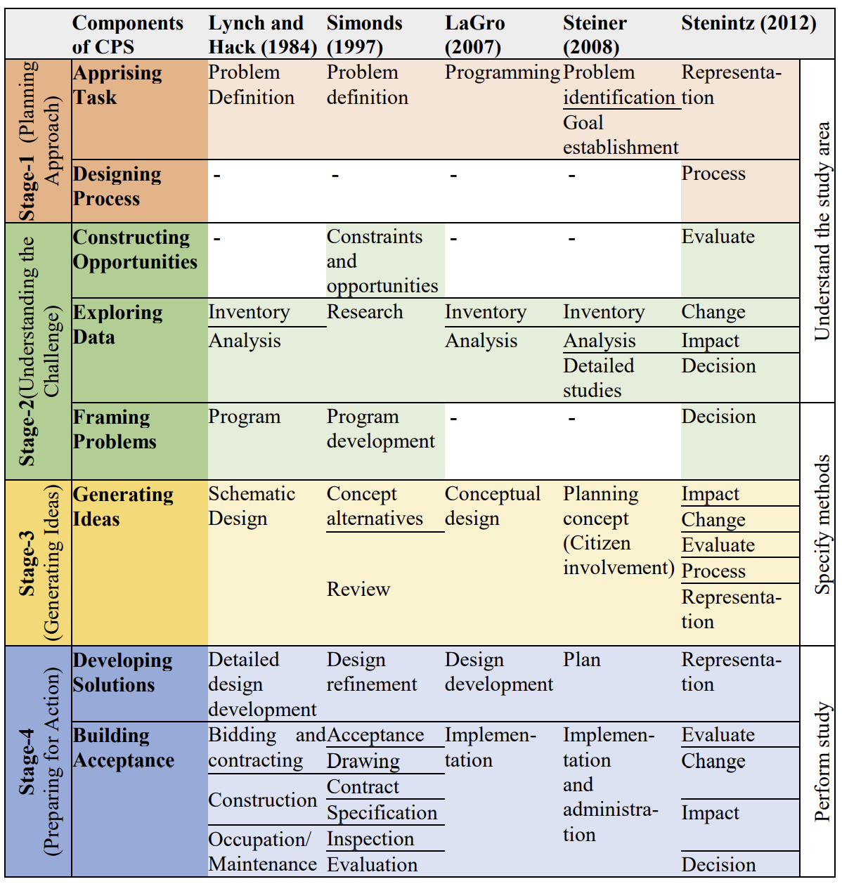
There are many existing planning processes intended to operationalize planning in different domains like site planning, landscape planning, and ecological planning. Out of which some notable planning processes have been developed by LaGro Jr (2011); Lynch and Hack (1984); Simonds (1997); Steiner (2008); Steinitz (2015). Most of the existing planning processes are based on Creative Problem Solving (CPS) framework, since the problem to be solved is complex and requires not only qualitative information but creative thinking as well (Bansal, V., 2017; Hsiao and Chou, 2004). Hence, the review of different processes developed for various domains of planning is essential. In the present study, the five processes that are established in the field of planning have been selected for review. These five processes are used for planning the physical environment which is compared in Figure 1.
The review suggests that all the processes developed for different domains of planning (ecological planning, landscape planning, and site planning) have a strong agreement in the different stages and components of the CPS framework. There is a slight variation in each planning process which is controlled by the purpose for which the process was developed. It is evident from the stage-wise comparison that there are a few missing components in four out of five processes (LaGro Jr, 2011; Lynch and Hack, 1984; Simonds, 1997; Steiner, 2008) seen as blank spaces in Figure 1. Only Steinitz’s geodesign process (Steinitz, 2015) has components corresponding to all the components of CPS framework. The component designing process of the CPS framework is missing in most of the planning processes under review. In a few of the processes, there is no component corresponding to exploring data, framing problems, and evaluation. The evolution of the planning processes from the CPS framework is quite evident from the detailed review of the processes, as both have many similarities in the functioning of their stages. The existing planning processes cannot be used directly because of the missing components of various stages which are crucial for planning at the site-level in hill regions. Hence, at last, the comparison of the planning processes establishes that Steinitz’s geodesign process (Steinitz, 2015) is comprehensive among all the other planning processes. Geodesign process is an iterative process to create a new physical entity or change the existing one for developing a more efficient, sustainable, and contextual solution that may not already exist. The geodesign process needs the support of many technologies together for developing an executable planning solution (Miller, 2012). The interoperability problem between many technologies generates the need for a single digital user-friendly platform for its implementation, which clearly defines the logical steps in the site-level planning process in hill regions to make it more transparent, rational, and understandable.
The present research aims at the development of the geodesign-based process for supporting planning at the site-level in hill regions, which was fulfilled through:
The research methodology has three stages as shown in Figure 2.

The literature about the conventional planning process at the site-level suggests that the process should have three main stages: site understanding, site analysis, and site synthesis for developing the solution (LaGro Jr, 2011; Lynch and Hack, 1984; Simonds, 1997). Therefore, in the present study, the proposed geodesign-based process has been divided into three cycles, which are: delineate the planning context, define the planning method, and execute the defined method, as shown in Figure 3, corresponding to the three stages of the conventional planning process. As discussed in the comparison of CPS-based processes in Figure 1, there are a few missing components in the processes compared, which are critical for site planning. These components are designing process, exploring data, framing problems, and evaluation. Among all the processes, Steinitz (2015) geodesign process is quite comprehensive and covers all the components. The process proposed in the present study is geodesign-based and includes all the missing components shown in Figure 1. In addition to this, active stakeholders’ input and the evaluation of the site planning solutions are also critical components for making efficient and sustainable site development. Therefore, the proposed process also includes the stakeholders’ input and evaluation of the solutions.

The three cycles of the proposed process corresponding to the three stages of the conventional planning process have 5 core steps as shown in Figure 3. The 5 core steps are understand problem, acquire data, factor influence, alternate scenarios, and assessment of impacts. These steps have a distinct purpose in each cycle. In the first cycle, the purpose of the core steps is to understand what data is required. However, in the second cycle, the methods of analysis of data to be acquired are selected. The third cycle deals with the implementation of the methods selected on the data to be acquired for finding out the site planning solution. In this cycle, alternate scenarios are generated by taking stakeholders’ input on the site zoning maps; these are assessed and compared for their impacts on the ecosystem. This helps in choosing the solution having the most positive impact on the site under consideration. Depending upon the extent of impacts, the alternate scenarios are altered till their impacts are positive.
Cycle-1: Delineate the Planning ContextThe present conditions of the site and the anticipated purpose of its planning are delineated in this cycle. It has five steps, which are the core steps because of their repetition in each cycle. The first step is understand problem, which includes identifying various facilities which are to be provided on the site under consideration and the collection of geographical data of the site. The second step is acquire data, which includes the identification of the physical factors for which the data is to be attained. The third step is factor influence, where the physical factors identified are prioritized for taking the site-level planning decision. The purpose of this step is the finalization of the method to be adopted for the evaluation of the weight of the physical factors. The fourth step is alternate scenario. The alternate scenarios are generated by the stakeholders based on their needs, priorities, the context of the site, and the anticipated purpose for development. The factors used to determine the change are termed change factors. In this step, change factors are identified. The fifth step is the assessment of impacts, with a focus on the identification of impact factors. Impact factors are used for assessing the impacts of generated alternate scenarios on the existing site, thus finalizing the scenario with the most positive impact.
Cycle-2: Define the Planning MethodThe second cycle focuses on finalizing the methods for analyzing the data collected in cycle-I. The order of the steps in this cycle is reversed, which makes the process more decision-oriented. This cycle has seven steps which include assessment of impacts, alternate scenarios, assessment of site, factor influence, site limitations, acquire data and understand problem. In the first step, the method for analyzing the impacts of the alternate scenarios is finalized to choose the best site plan for the project under consideration. In the second step, the method of generating alternate scenarios based on change factors is finalized, whereas, in cycle-I, change factors are identified. Further, the method for assessment of the site is finalized. The next step involves the finalization of the method for determining the weights of the identified physical factors for evaluating the site and creating suitability maps, which are further used as a base for generating alternate scenarios. In the next step, the limitations of the site are identified, as it restricts the site from development or to be used for a particular purpose. This is done by analyzing the data layers corresponding to each physical factor based on the provision of various codes for the development in hill regions. The next step involves the finalization of the sources for acquiring the data about the physical factors. The last step of the second cycle is structuring the planning problem.
Cycle-3: Execute the Defined MethodsThe third cycle deals with the actual execution part where the data acquired and the methods finalized are executed to provide the site planning solution. The steps involved in this cycle are understand problem, acquire data, data organizing, factor influence, site zoning, alternate scenarios, and assessment of impacts. In the first step, a detailed description of the proposed site and the planning problem are provided which helps in reaching a planning problem statement. It is an important step, as a minor deviation in the planning problem statement may lead to an immensely different planning solution. In the second step, the present condition of the proposed site is represented in the form of data layers corresponding to the identified physical factors. In the third step the data layers are organized and structured for the evaluation of the site. Also, the limitations of the proposed site are modeled based on various code provisions about the identified physical factors. In the fourth step the weights of the physical factors are determined by using the method finalized in the second cycle, for taking site-level planning decisions. Further, site zoning maps are prepared keeping in view the weights of the physical factors, their code provisions, and site limitations.
In the next step, alternate scenarios are generated based on change factors by taking site zoning maps as the input. The identification of the change factors and method of generation of alternate scenarios are decided in the first and second cycles respectively. Further, the alternate scenarios are assessed for their impacts on the ecosystem by using the impact factors. This helps in choosing the solution with the most positive impact on the site under consideration. In case, the impacts are negative, it requires feedback, which implies that the alternate scenarios are redesigned till the proposed planning solution has a positive impact on the present condition of the site. Depending upon the extent of impacts, the alternate scenarios are altered till the impacts are positive. Finally, the solution to the site planning problem having the most positive impact on the ecosystem is selected for implementation on the site.
The geodesign-based process was planned to be validated through its implementation in the planning of a new project and locating additional facilities in an existing project. Hence, for its implementation, two case studies were selected. The case study-I belongs to the planning of a new institutional campus of Himachal Pradesh Technical University (HPTU) Hamirpur, India. It is located between the longitude of 76°28'40"E to 76°29'40"E and latitude of 31°40'30"N to 31°41'30"N at an altitude of 785 meters and area of 130 acres.
The case study-II belongs to locating a few additional facilities in an existing campus of the National Institute of Technology (NIT), Hamirpur, India with the area of 177 acres. It is an engineering institute, which has various academic, residential, recreational, administrative buildings, along with other supporting facilities/utilities. In addition to this, the campus has open gathering spaces such as a playground, student parks, and various lawns. The results of the implementation of the developed process for the planning of both sites have been discussed individually in the subsequent sections.
The implementation of the process requires the identification of the physical, change, and impact factors. The comprehensive list of 21 factors and their categorization into physical, change, and impact factors identified by Kapoor, Neetu, Jain et al. (2020) was used in the present study. The site’s slope, elevation, surface runoff, groundwater table, soil type, vegetation, land use, existing utilities, aspect, and accessibility were identified as the 10 physical factors. Climate, visual aspects, wildlife, distance from other activities, wind direction, historic factors, and functioning of the site were the 7 change factors identified, out of which only 5, namely climate, visual aspects, distance from other activities, wind direction, and functioning of the site were applicable for the sites under consideration. The consideration of 2 change factors namely historic association and wildlife were not applicable for both the sites. The 4 impact factors identified by Kapoor, N., Jain et al. (2019) are ecological value, landscape character, socio-economic conditions, and population density. Out of the 4 impact factors, only ecological value and landscape character were used for the two sites under consideration. Both the sites are covered by forest land which is required to be changed to built-up land which will have an impact on the landscape character of the sites under consideration. Moreover, both the sites are located in ecologically sensitive areas, thus, the impact of the two sites was considered in terms of these factors. Hence, landscape character and ecological value were selected as two impact factors for both the case study sites. In addition to this solar irradiance was also considered as an impact factor (Sugihara and Shen, 2017). To resolve the issue of interoperability, a common user-friendly platform of GIS was used. A GIS-based working methodology was developed for taking planning decisions in both case studies.
The GIS-based working methodology for the automation of the cycle 3 of the developed process is shown in Figure 3. First of all, the relevant data were collected corresponding to the 10 physical factors for creating corresponding data layers. The data layers of elevation, slope, aspect, and surface runoff were created using an elevation raster from the topographic survey data. The data layer corresponding to accessibility was created from the existing road network. Similarly, data layer of existing utilities was also created. The satellite image was analyzed through the Normalized Difference Vegetation Index (NDVI) for creating a data layer of vegetation. Data related to the groundwater table, soil type, and land use was taken from the Survey of India (Survey of India, 2020). In addition to this, shapefiles were also developed for representing existing facilities/utilities on both the sites which include existing buildings, water supply network, sewer network, manholes, and boundary wall.
The number of classes in the 10 data layers corresponding to 10 physical factors was different, for example, a layer corresponding to the aspect which was created by using elevation raster had 9 classes and a layer corresponding to accessibility had 2 classes. Further, the data layers were reclassified to the common scale of 1 to 4. The planning regulations of India (Bureau of Indian Standards, 2016; Ministry of Urban Development, 2014) and reported literature (Bansal, V. K. and Pal, 2008; Chakma, 2014; Dai, Lee et al., 2001; Dong, Zhuang et al., 2008; Neisser, 2014) were reviewed for classifying the data layers corresponding to the 10 physical factors.

The suitability ranges of the 10 physical factors for the 3 desired areas of case study 1 and desired area for built-up for case study 2 are given in Table 1. The overlay analysis of the reclassified data layers led to the development of suitability maps of the site for the desired areas. The suitability maps thus generated were used for taking stakeholders’ input for the creation of alternate scenarios of the planning solution. The alternate scenarios were compared by using the impact factors and the scenario with the most positive impact was chosen for the generation of the final site plan.
| Physical Parameters | Site |
Areas/ Zones |
Reclassified value | |||
|---|---|---|---|---|---|---|
| 1(Most Suitable) | 2(Moderately Suitable) | 3(Less suitable) | 4(Least Suitable) | |||
| Slope (Degree) | Case Study-1 | Built-up | 0° to 15° | 15° to 25° | 25° to 35° | Greater than 35° |
| Open | 0° to 10° | 10° to 20° | 20° to 25° | 25° and above | ||
| Green | Greater than 45° | 30 to 45° | 10° to 30° | 0° to 10° | ||
| Case Study-2 | Built-up | 0° to 15° | 15° to 25° | 25° to 35° | 35° to 58° | |
| Elevation (Meters) | Case Study-1 | Built-up | 800-870 | 750-800 | 700-750 | 630-700 |
| Open | 700-750 | 750-800 | 630-700 | 800-870 | ||
| Green | 630-700 | 700-750 | 750-870 | - | ||
| Case Study-2 | Built-up | 850-891 | 840-850 | 830-840 | 819-830 | |
| Soil type | Case Study-1 | Built-up | Fine loamy soil with slight erosion | Calcareous fine loamy soils with moderate erosion | - | - |
| Open | Fine loamy soil with slight erosion | Calcareous fine loamy soils with moderate erosion | - | - | ||
| Green | Calcareous fine loamy soils with moderate erosion | Fine loamy soil with slight erosion | - | - | ||
| Case Study-2 | Built-up | Calcareous fine loamy soils without erosion | Calcareous fine loamy soils with moderate erosion | Fine loamy soil with slight erosion | Fine loamy soil with severe erosion | |
| Vegetation | Case Study-1 | Built-up | NDVI -1 to 0 | NDVI 0 to 0.5 | NDVI 0.5 to 0.8 | NDVI 0.8 to 1 |
| Open | NDVI 0 to 0.5 | NDVI -1 to 0 | NDVI 0.5 to 0.8 | NDVI 0.8 to 1 | ||
| Green | NDVI 0.8 to 1 | NDVI 0.5 to 0.8 | NDVI 0 to 0.5 | NDVI -1 to 0 | ||
| Case Study-2 | NDVI -1 to 0 | NDVI 0 to 0.5 | NDVI 0.5 to 0.8 | NDVI 0.8 to 1 | ||
| Surface runoff | Case Study-1 | Built-up | 4m away from flow accumulation | 3m away from flow accumulation | 2m away from flow accumulation | Less than 2m away |
| Open | 4m away from flow accumulation | 3m away from flow accumulation | 2m away from flow accumulation | Less than 2m away | ||
| Green | Less than 2m away from flow accumulation | 2m away from flow accumulation | 3m away from flow accumulation | - | ||
| Case Study-2 | Built-up | More than 4m away from flow accumulation | 3m away from flow accumulation | 2m away from flow accumulation | Less than 2m away from flow accumulation | |
| Land use | Case Study-1 | Built-up | Scrub land | - | Agricultural land | Forest land |
| Open | Scrub land | Forest land | Agricultural land | - | ||
| Green | Forest land | Agricultural land | Scrub land | - | ||
| Case Study-2 | Built-up, Urban | Scrubland | - | Forest | ||
| Aspect | Case Study-1 | Built-up | S, SE, SW | W, E | NE, NW | N |
| Open | S, SE, SW | W, E | NE, NW | N | ||
| Green | N | NE, NW | W, E | S, SE, SW | ||
| Case Study-2 | Built-up | S, SE, SW | W, E | NE, NW | N | |
| Accessibility (Meters) | Case Study-1 | Built-up | Within the reach of 100m from the road | More than 100m distance from the road | - | No vehicular Access |
| Open | 6- 100m from the road | More than 100m from the road | Within 6m from the road | - | ||
| Green | No vehicular Access | More than 100m distance from the main road | - | Within 3m from the road | ||
| Case Study-2 | Built-up | Within 20m from the road | Within 50m from the road | Within 100m from the main road | Within 6m from the road | |
| Groundwater table (Meters) | Case Study-1 | Built-up | 40 to 50 | 32 to 40 | - | - |
| Open | 40 to 50 | 32 to 40 | - | - | ||
| Green | 32 to 40 | 40 to 50 | - | - | ||
| Case Study-2 | 50 to 60 | 42 to 50 | 38 to 42 | 30 to 38 | ||
| Existing utilities | Case Study-1 | Built-up | More than 6m from existing utilities | More than 40m away from existing utilities | More than 3m away from existing utilities | Within 6m from existing utilities |
| Open | More than 40m from existing utilities | More than 6m from existing utilities | More than 3m from existing utilities | Within 3m from existing utilities | ||
| Green | More than 50m from existing utilities | Within 50m from existing utilities | - | - | ||
| Case Study-2 | Built-up | 10m to 20m from existing utilities | 20m to 30m from existing utilities | 30m to 40m from existing utilities | Within 6m from existing utilities | |
The site map and 3D views of the virtual surface model of the HPTU campus from different directions are shown in Figure 5. The site is in 4 parts, which are located close to each other. The planning of the site involves the identification of land for 3 different types of areas, which were built-up, open, and green areas.

The suitability maps for all desired areas were created by using the weighted overlay of the reclassified data layers of 10 physical factors. The determined weights of the physical factors for the built-up, open, and green areas were taken from the study by Kapoor, Neetu, Jain et al. (2020). This categorized the proposed site into 4 suitability classes for each desired area. These maps were shown to the stakeholders for their input. The proposed site had 3 classes of stakeholders which included students, faculty, and people from the administration. 4 members from each class were invited to participate in the workshop which was conducted for taking their input on the suitability maps by keeping change factors in consideration. Each class of stakeholders developed a planning solution in the form of a scenario, based on their requirements.
The 3 alternate scenarios generated were compared to each other based on the impact factors as shown in Table 2. It was found that alternate scenario 2 has minimum surface runoff, which makes it the most efficient planning solution in terms of its impacts on the existing surface runoff. In terms of landscape character and solar irradiance, alternate scenario 1 is the most efficient. Alternate scenario 1 has the maximum area under conserved green forest and additional green area, which makes it the planning solution with the most positive impact on the proposed site. Similarly, alternate scenario 1 has the maximum solar irradiance out of the three generated scenarios. Hence, alternate scenario 1 was selected as the final map of the proposed institutional campus as shown in Figure 6.
| Surface runoff | Landscape Character | Solar Irradiance | |||
|---|---|---|---|---|---|
| Alternate Scenario | Surface runoff (number of cells draining at a point) | Landscaped Area (sqm) | Additional Green area (sqm) | Conserved Green Forest (sqm) | Solar irradiance (KWh/sqkm) |
| Scenario 1 | 35122 | 13525 | 111232 | 133243 | 1810195 |
| Scenario 2 | 10529 | 27979 | 110121 | 119900 | 1734310 |
| Scenario 3 | 28245 | 15684 | 108675 | 133641 | 1627918 |

The initial site plan of NIT Hamirpur as shown in Figure 7 was prepared in 1986. The conventional planning process was being used to locate new facilities in the campus. This was the motivation behind the selection of NIT Hamirpur as the second case study, where a few additional built-up facilities were to be added. The buildings located using the conventional site planning process were analyzed for their impacts on the existing ecosystem of the site. It was found that the buildings were located in the natural drainage basin which had negative impacts on the existing ecosystem, as the natural drains were required to be diverted during the rainy seasons and during the construction of buildings. Moreover, more retaining work was required to protect the buildings from all sides. The post-occupancy analysis of the buildings revealed that the buildings were exposed to various problems which require frequent repair and maintenance.

Keeping in view the different problems faced by the buildings located using the conventional site planning process; few buildings were located using the geodesign-based process proposed in the present study with the permission of the institute administration. The location identification for the upcoming buildings on the campus is highly influenced by the site topography because of being in hilly terrain. Hence, the geodesign-based process helped in providing the most efficient and sustainable solution.
The 3 cycles of the developed process were executed for the identification of suitable locations for the required built-up facilities, which were a girls’ hostel, a boys’ hostel, and an academic building for management studies. The identification of locations for the newly built-up facilities was difficult manually, because of the constraints like existing buildings, complex topography, and complex layout of existing facilities/utilities. The weights of the physical factors used in the present study for locating built-up areas were taken from the study by Kapoor et al. (2020). Suitability ranges of the 10 physical factors for locating the 3 buildings are given in Table 1
The suitability map was created by using the weighted overlay of the reclassified data layers of the 10 physical factors. The developed suitability map was in raster format, which was converted to vector format. The site locations in the vector maps were filtered to exclude a few site locations having an area less than the minimum area requirement out of the 3 buildings. The 4 filtered site locations which were identified as most suitable for the 3 buildings of the campus are shown in Figure 8.
The map containing the 4 filtered locations was presented in the workshop to the stakeholders for their input. Similar to case study I, members from each class of stakeholders were invited for taking their input for deciding the site locations for the 3 buildings. “Location-1” shown in Detail-A of Figure 7 was selected for the new boys’ hostel with an area of 656 square meters. The “Location-2” shown in Figure 8 was selected for the new academic building for management studies with an area of 662 square meters. The “Location-4” shown in Detail-C of Figure 8 was selected for the new girls’ hostel with an area of 1392 square meters. “Location-3” as shown in Detail-B of Figure 7 with an area of 1296 square meters was not selected for locating any of the 3 buildings because it is in the recreational zone, is close to a playground, sports complex, and an open-air theatre, which makes it most suitable location to be reserved for any forthcoming recreational building.

The growing demand for infrastructure posed by rapid urbanization and growing population pressure has a lot of negative impacts on the natural ecosystem of hill areas. The management of land through systematic planning is the best way to mitigate negative impacts. The review of the documented processes used for different domains of planning has established that the geodesign process used for landscape planning is the most comprehensive among all the other planning processes in mitigating negative impacts. The contribution of this study is the geodesign-based process for taking contextual and sustainable site-level planning decisions. The cyclic nature of the developed process makes it decision-driven rather than data-driven.
The other contribution is the development of the GIS-based working methodology for the execution of the geodesign-based cyclic process. It considers the physical factors and analyzes them using spatial analysis capabilities of GIS to develop suitability maps which were further presented for input of stakeholders based on which alternate scenarios of the site plan were developed. The alternate scenarios are created based on the qualitative judgment of stakeholders by using change factors. The alternate scenarios are assessed and compared for their positive impacts. The scenario having the most positive impacts is finalized as the most efficient planning solution. It may not always be possible to obtain one alternate scenario having the most positive impacts. In such cases, an alternate scenario having maximum positive impacts is altered to provide the most efficient planning solution.
The developed process was validated on the two case studies, first on a new project and second on an existing project. In the first case study, the physical design of the institute campus was desired by deciding built-up spaces, green areas, and paved surfaces. The planning solution derived from the developed process has 10% additional green area and conserved forest. The solution also resulted in 30% less surface runoff and 11% more solar irradiance. In the second case study, locations for a few additional buildings required in the existing infrastructure were suitably identified. The implementation established that the planning decisions were contextually more appropriate in conserving the sensitive ecosystem of the sites under consideration.
The developed process is collaborative, scale-independent, technologically dependent, data-driven, and iterative in nature. The process is helpful for both academicians and practitioners. It fills the gap by providing a rational quantitative approach in academics. In the absence of a structured process to solve complex site-level planning problems, for practitioners, it assists in solving the practical problem faced by planners in practice. Despite all the suggested outcomes, it may be taken forward in the future to strengthen the site-level planning process in hill areas. The developed planning process may be made more interactive and collaborative by making it web-based. In addition to this, an efficient scenario management is also required.
Conceptualization, V.K.B. and N.K.; methodology, V.K.B.; software, V.K.B. and N.K.; investigation, N.K.; resources, V.K.B.; data curation, V.K.B.; writing—original draft preparation, V.K.B. and N.K.; writing—review and editing, V.K.B. and N.K.; supervision, V.K.B. All authors have read and agreed to the published version of the manuscript.
The authors declare that they have no conflicts of interest regarding the publication of the paper.
The authors would like to thank the Management of Himachal Pradesh Technical University and National Institute of Technology Hamirpur for sharing the data and information for planning the campus.