Introduction
Coastal regions are the world's most prominent human settlement areas based on population, geo-strategic, climatic, and environmental evidence (Creel, 2003). The coastal region is a transitional area between the hinterland and the sea. Coastal regions account for less than 20% of the hard surface but more than 45% of the world's population (Dewi and Bijker, 2020). Since the beginning of the 21st century, numerous stresses have occurred in coastal areas and the population strains induced by urban migration (Costanza, Kubiszewski et al., 2011). Therefore, many developed countries have introduced new cautious coordination across coastal areas. Rural-urban components with a spatial planning system began in coastal regions, including the adjacent marine environment (Galland and Enemark, 2013).
Traditional planning paradigms with fixed boundaries led to the establishment of organizational maps for urban and rural settlements. Nevertheless, without discipline, such models negatively affect the ability to effectively address urban-rural spatial problems, social differentiation, and local migration; however, these models, solidify the concept of rural isolation (Zheng, Y., Tan et al., 2022). Thus, the spatial dimension of development planning has been one of the main challenges resulting from these dramatic changes in the world's demographic structure (Bulderberga, 2014). Sustainable spatial planning relies on recognizing and using regional differences to facilitate the organized growth of the intended geographic area. In the same context, sustainable development cannot be based on the principle of contradiction, competition, and conflict between the two types of land but rather on the interaction built on their mutual/shared points in the context of spatial development (Rahmoun and Zhao, 2020). This interaction depends on a win-win event promoting socio-economic linkages using spatial development clusters and networks (Tacoli, 2003; Van Leeuwen, 2015).
On the other hand, innovation can be defined as "discovering new things and the commercialization of such discoveries" (Tomenendal and Raffer, 2017). Innovation is a key element of regional economic development. Additionally, regions are considered fundamental for knowledge production and innovation. Since its development in the 1990s, the Regional Innovation approach has attracted considerable attention from economic geographers, innovation scholars, and policymakers (Asheim, Grillitsch et al., 2016). Innovation stems from a regional perspective—from the most general approaches that illustrate the change, upgrade, flexibility, and development to improve the performance of internal and external factors (Olah and Alpek, 2021). The regional innovation models "RIMs" represent a series of evolution routines that could be changed by economic development and building transportation networks(Zheng, Q. and Bao, 2022). Therefore, RIMs become the prime innovator and driver of regional growth and development of collective entrepreneurship through a partnership among the business, academic and scientific players, and regional government, which is known as "the triple helix" (Danson and Todeva, 2016). RIMs approach takes into consideration that innovation, as well as learning, will undoubtedly enhance the market-economic efficiency and boost the competitiveness of an area or region.
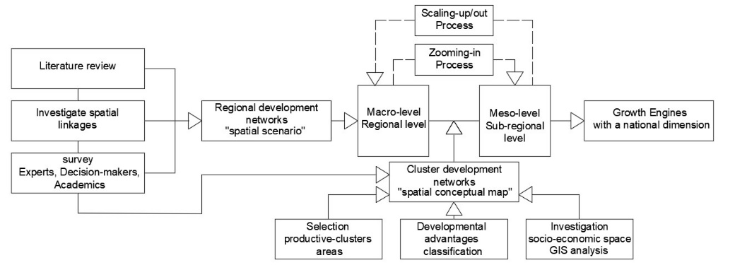
In the planning field, spatial networks are utilized as a mechanism of "new" and "positive" coordination of established social relationships between interdependent actors (Provan and Kenis, 2008). Such a mechanism is integrated with the concept of a cluster, a geographic concentration of productive sectors that could be competing and cooperating/complementing each other. Clusters and networks are different yet linked phenomena (JICA., 2015). Clusters constitute socio-economic systems where the population of enterprises often overlaps with the communities living and working within a specific area or territory (UNIDO, 2020). Networks aim to achieve the efficiency of regional policies and management capacity (Boumans and Ferry, 2019). It is an ideal concept because of its flexibility and horizontal organization; creating added value at the spatial level through employment opportunities, wealth, and well-being raises regional competitiveness (Lopes and Franco, 2019). Networks are found in many forms and geographical contexts. The network's core idea is that one party is dependent on resources and competencies controlled by another, and fruitful results arise if the resources and competencies are integrated (Sotarauta, 2010). In fact, nodes and linkages are the main contents recognized in the network planning space. Nodes host clusters of various activities and collective structures where functions and actors are agglomerating. Linkages could crystallize under hard infrastructure as physical networks and soft infrastructure as functional and social networks. The physical linkages are the corridors, axes, and transportation roads connecting main clusters, "agglomeration centers" in urban and rural areas, and extending through the regional space (Ogrodnik, 2019). At the same time, cluster management measures between rural settlements and cities could employ the physical linkages in building spatially functional networks (Friedmann, 2007; OECD, 2019) (Figure 1,a). Thus, powerful regional centers anchor clusters in the networks (Douglass, 1998). Then, the spatial networks create a hierarchy of centers suited to serving the population's different needs at different spatial scales "regional, district, sub-district" (Curtis and Tiwari, 2008) (Figure 1, b). However, the spatial structure of regional innovation models with the establishment of regional development networks becomes the reference for innovation policy in a way that is complementary to the cluster approach (Vale, 2010), with a change in spatial structure from a center-periphery ring structure to a hub-network structure and transfer innovation to the periphery (Zheng, Q. and Bao, 2022).

Concerning regional policy, the top-down planning approach may account for the necessary but insufficient conditions needed to identify the regional networks. A top-down approach is a clear-cut system of planning and control by the government that showcases: clear and consistent goals articulated at the top of the hierarchical planning system with knowledge of pertinent causes and effects (DeLeon and DeLeon, 2002). In the same context, top-down planning is based on unproven environmental and social behavior assumptions that are proven wrong most of the time because social formations and localities vary (Waniganeththi, 2017). Nevertheless, regional and strategic planning is attributed to the top-down "macro-to-meso" perspective. In contrast, local planning involves the bottom-up participatory approach "micro-to-meso" perspective, which takes account of the regional embedded socio-economic structures (Pissourios, 2014). On the meso level, clusters and networks innovations are strongly supported, owing to clusters as a specific type of network concentrated in a particular geographical area (Tomenendal, Raffer et al., 2018). Precisely, spatial cluster structures refer to the interaction "cooperation and coordination" of all producer actors and stakeholders with a spatial structure that forms an integrated network in a specific region (Khodabandehloo, 2014; Wanzenböck, Scherngell et al., 2015). Yet, networks provide the connections between clusters on meso and macro levels to achieve common goals. Thus, integrating the top-down approach with a bottom-up perspective is necessary to build new competencies that involve establishing links at all levels. Hence, the structural discipline of the meso level during complex changes between macro to micro levels resulting from socio-economic changes drives a spatial space that attracts development scenarios and policies under RIMs.
Based on those concepts mentioned above, the spatial development initiative SDI in this research is an aspect of RIMs. SDI ensures that the infrastructure necessary for achieving the goals of RIMs is identified and prioritized by formulating spatial structural frameworks and development projects to include areas of unrealized economic potential, thereby enhancing the development potential in a mixed approach. SDI aims to achieve balanced development with the inclusion of communities and small businesses "cluster projects" alongside larger investments "anchor projects"(Gálvez Nogales, 2014; Jourdan, 1998). Therefore, spatial cluster structures could be the key feature of the potential application of the SDI in the Syrian coastal region depending on the planning assets hosted by the regional space where the SDI program is premised on several key points:
-
-
Some areas of the region have unrealized economic potential due to various historical and political reasons.
-
-
Through meticulously planned, targeted interventions, the local authority government can help uncover the spatial potential and help with new financial investment in these locations considering environmental assets to achieve physical sustainability.
-
-
This could increase economic efficiency by offering job production and wealth generation in the places concerned by identifying strategic investment opportunities in the SDI location to reinforce the performance of human resources in the local/regional economy.
Hence, this paper discusses a) whether the spatial development initiative SDI is suitable for the development process considering its national dimensions by adopting spatial cluster structures related to the Syrian coastal region planning assets b) the role of spatial development networks in increasing sub-region's competitiveness and c) issues related to the question of how to limit rural spatial fragmentation by rebuilding an urban-rural resilient network that combines physical linkages with economic aspects in a new model of spatial structure.
Result and Discussion
Results of questionnaire analysis
The first part of our survey results is shown in Figure 3 and Figure 4, where on average, almost 85% of respondents agreed with the proposals' strategic keys. Figure 3 includes points dealing with aspects concerning building new spatial-functional structures and physical networks to re-build the industrial, agriculture, tourism, trade, and services regional map based on coastal region needs. In comparison, the sample results show that more than 80% strongly agreed/agreed with the region's spatial dimensions that go over the regional administrative border to the marine space and hinterland (q5). However almost 90% of answers were "strongly agree/agreed" concerning the evaluation of the coastal region's role as an economic gateway in global trade networks after the war, with the national role of the coastal region within the integrated regional planning that adopted a OBOR strategy through Syria (q6), See Figure 4 (a) for more information. On the other side, (q7, q8) results support the need for RIMs in the light of a comprehensive and multidimensional process of the new regionalism approach to moving toward a new spatial development networks strategy under the umbrella of SDI, (Figure 4, b). In this scope, more than 70% were "strongly agree/agreed", vs almost 10% "disagreed" with adopting new geographic planning units, "river basins" that support the administrative units to help guide urban-rural interaction linkages for sustainable development (q9). Moreover, 85% of respondents emphasized its role in coordinating planning relationships between actors, stakeholders, and government authorities to achieve environmental security depending on the social and spatial characteristics and environmental sensitivity of river basins (q10), See Figure 4 (c) for more information.


The second part of the questionnaire shows evidence in Figure 5 and Figure 6 that the spatial cluster development networks strategy could be a suitable regional development vision in the coastal region. Such evidence led to results showing that about 68% of respondents supported the spatial cluster development networks strategy under SDI to guide regional planning compared to 28% supporting the development axes strategy (q11). At the same time, about 95% emphasized that we need to change the current concentration action of the growth poles strategy (q12), Figure 5 (a). However, most respondents mentioned that the cluster development networks initiative has two complementary aspects. The cluster structure term includes several planning dimensions, including economic, spatial, social, cultural, institutional/political and environmental (q13). Furthermore, the spatial development networks refer to physical and functional networks/networking required to link clusters of actors within the regional space (q14). See Figure 5 (b) for more information. At the same time, Figure 5 (c) shows respondents' answers on the role of the participatory approach in enhancing SDI benefits.

The investigation used the rating scale to evaluate planning problems in the coastal region and considered evaluation (3) as the neutral evaluation. The answers concurred with the depletion of natural resources, marginalization of the rural centres, inability to provide sustainable employment opportunities, and spatial randomness in the development of economic sectors. Those opinions earned the highest rating followed by the weak rural-rural spatial linkages and the absence of an integrated regional industrial map (q16). While (q17) shows the reasons for the decline in the contribution of the economic sectors to the coastal region's GDP. The results were very close and showed high ratings with an advantage for the absence of a spatial structure for growing economic small and medium-sized enterprises "SMEs" and weak marketing for regional products. According to experts' answers, the weak investment in the tourism sector and its absence in the agricultural sector were recorded at notable rates: Figure 6(a).
By assessing the effecting factors in the application of the cluster development networks initiative at the regional level (q18), the analysis results show a convergence of rating values (4, 5). With the weighting of the highest evaluation 5, we could find that a shift towards a decentralized planning approach achieved the highest rating. On the other hand, regarding evaluating investment priorities that would support the initiative's implementation, the results focused on building agricultural clusters and developing the infrastructure of the agricultural sector with the highest evaluation (5).
The same assessment recommended investing in establishing integrated industrial clusters, while the tourism sector clusters came third (q18). See Figure 6 (b). In terms of appraising the potential spatial role of nodes within the cluster development networks proposed scenario at the regional level (q20), in this domain, 60 - 80 % of the respondents gave odds to the following three options: regional logistic hubs, national/foreign investment attraction hubs, and rural-urban growth poles. In contrast, sample results showed the futuristic fruits that could be reaped from implementing the spatial cluster development networks strategy within the coastal region (q21). The weighting of the highest evaluation (5) moved toward options related to the economic benefits based on the transformation from the geographic concentration of productive sectors competing to cooperating/complementing regional economic sectors by utilizing the spatial structure of the proposed scenario on the meso and macro levels. In comparison, the highest weighting of evaluation (4) was recorded on gains that gave the scenario the advantage of achieving urban-rural sustainable development besides the possibility of realizing a national brand for the coastal region economy, Figure 6(c).

The categories with the highest rating were adopted to formulate the proposed final spatial development model for the coastal region and its recommendations. Specifically, the second part of the questionnaire included other open questions dealing with the stages of planning and implementation of the proposed scenario, as well as collecting opinions about the scenario's impact on urban expansion at the expense of agricultural lands. It was essential to gather and analyze the respondents' opinions before defining/adopting the proposed sustainable development initiative because of the critical role of the new regionalism approach adopted by the eleventh five-year plan and the emphasis on the national dimensions of any regional development strategy in the reconstruction phase in Syria.
The macro-level of proposal regional spatial networks
River basins are major geographical units in the coastal region. Such basins are home to urban and rural agglomerations, within the administrative hierarchy, from districts, sub-districts, cities and villages, with a built-up area equivalent to approximately 8.7% of the region's area. Despite the built-up area change from 200.91 sq. km in 2010 to 380.50 sq. km in 2018, the urban-rural areas are characterized by weak spatial direct links in the mountainous environment across river basins. Vice versa has a good spatial correlation between mountainous and coastal areas, i.e., between the human settlement in the highlands "mountains – hills" and the main coastal cities extending along the coastal strip (GCSC and RPC, 2020). Transport infrastructures suffer from weak efficiency due to a lack of operating standards. Simultaneously, it needs to upgrade through two dimensions: 1) vertically through improved efficiency and technique modernization, and 2) horizontally through physical network expansion. The improvement stage includes the existing four primary "regional-regional" linkages between the coastal areas and district centers in mountainous areas. In contrast, the expansion stage includes four secondary "regional-local" linkages to achieve interconnection through the hilly areas and high mountains. Together they form the proposed regional physical network.
Today, urban centers play a basic role as growth poles for the rural areas and welcoming socio-economic facilities. Otherwise, these centers are far from performing their regional dimensions for logistical centers and dry/wet regional gateways that open doors to link the region with the inland and maritime space. Therefore, previous spatial facts steer researchers to a new spatial scenario that upgrades the central place theory's structural principle to the central flow theory. This transition explains the economic-spatial dimension for agglomeration of the rural economy to the closest urban center and then to diffusion after exceeding economic advantages toward a polycentric economic structure with a new spatial interaction within the spheres of influence (Niu, Liu et al., 2018). Thus, the proposed scenario seeks to confirm the role of rural areas as an equivalent part of the regional space working in structural, physical, and functional interaction with the urban centers to build the regional system (Zheng, Y., Tan et al., 2022).
In our case, the "river basin" forms the influence space, where the human settlements within river basins recorded stronger physical, social, and economic ties. Moreover, mountain human resources are also an indispensable part of the basin ecology; their impact on the basin's environmental changes is increasing daily. It is even directly affecting the ecological balance and development of the basin (Rahmoun and Rahmoun, 2019). On a different angle, the hierarchy of spatial urban center values was respected on the regional level to classify the tier and the pattern of physical/functional linkages in parallel with techniques required to overcome topographic barriers. Figure 7 shows the macro-level spatial physical/functional networks and networking of urban-rural settlements in the coastal region based on the impact of urban influence. The proposal linkages at a macro-level will be the backbone of the transition at the meso-level towards a new urban-rural spatial structure by adopting a new planning DNA through spatial cluster development initiatives and network development strategy.

A zooming-in is used to have a good knowledge of planning assets and opportunities by dividing the coastal region into three geographical sub-regions: northern, middle, and southern sub-region (Figure 7). Therefore, to study the spatial networks/networking on the meso-level, we focused on the southern part as a pilot sub-region to transfer knowledge/learned lessons to the whole region. It is located between 34°38′ to 35°3′north latitude and 35°51′to 36°19′east longitude, covering an area of 1194.86 sq. km, with five rivers basin. It includes two main basins; Al-Abrash river basin A/RB, and Al-Hseen river basin H/RB. It also includes three secondary basins; Al-Ghamqa river basin G/RB, Al-Mntar river basin M/RB, and Al-Kabir al-janobi river basin K/RB, with about 79% of Tartous province population, Figure 8(c).
The built-up area has witnessed a steady expansion during the past decade, from 76.82 sq. km in 2010 to 87.32 sq. km in 2014 and then 123.60 sq. km in 2018. The expansion increased the environmental resource pressure since almost 50% of the built-up expansion was outside the organizational plans' boundaries (GCSC and RPC, 2020). Moreover, the area has a high-density village distribution and high-frequency urban-rural correlation. Therefore, it is a suitable sample for the proposed model to build new rural-urban spatial linkages considering current and futuristic planning indicators, including:
1-Planning assets to build integrated cluster-networks spatial development.
2-Promising investment economic sectors, including the "agriculture- tourism- trading," which needs upgrading for the industry and services sector.
3-Area capabilities could constitute future development opportunities at the national level as an economic free zone (Hamze, 2019), especially after the Legislative Decree No. 257 of 2003.
4-The southern geographic window of the region is a viable candidate to welcome one of the international trade belts within the OBOR strategy connecting the Tartous port with the Iraq border (Zasiadko, 2019).
5-Reducing the informal expansion of built-up areas by adopting a policy of sustainable inverse densification in urban sprawl areas.
Hence, GIS technology is used to classify the current planning dimensions into many classes: TIN map, the tourism map, the built-up expansion map, the administrative and transportation map, the industrial and services map, and the land-use map (Figure 8). GIS analysis relied on data and information from the relevant government departments. Such analysis is essential in understanding the impact/risk factors of the current situation and the study area's future instead of being copied from a pre-existing map. Because each river basin has a distinctive character regarding the proportion of the urban-rural expansion diffusion and places of settlement along the basin topography sections and the difference in human activity affecting (Rahmoun, Zhao et al., 2018), it leads the actions to make changes in the urban/rural relation and supports the "preparation stage" of cluster structures toward rural revitalization scenarios to complement the structural framework of spatial development networks.

Conceptual planning maps are crucial tools for recognizing local contexts and offering specific platforms for discussion and participation. Design-makers can use structural conceptualization to develop a conceptual framework to guide evaluation or planning (Trochim, 1989). The proposed structural map at the meso-level depends on the sub-region's internal development capabilities in parallel with the ability to attract critical strategic investments and upgrade human settlements' spatial roles depending on the cluster development. Therefore, the previous GIS analysis results plus the multi-tiers classification of indicators intersection, including GDP, density, human activity, workforce, services, infrastructure, and location were utilized to build the developmental advantages classification map. Figure 9 (a) shows the tiers of classification: current growth hub location, settlements agglomeration qualified for development policies priority 1&2, settlements agglomeration with special planning advantages "regional gateways", and settlements that need development support, which fall within the area of influence of cluster development networks.
On the other hand, GIS analysis results and the logical investigation of the socio-economic space facts in both rural and urban areas are guiding dimensions for formulating the cluster development networks scenario. The emerging clusters in the proposed scenario are grounded on four primary urban centers -district centers- "Tartous, Safita, Dreikish, and Sheikh Badr" with twelve secondary urban/rural centers "sub-district centers" distributed within the geographical and economic planning space of the primary urban centers (Figure 9). Such centers have the potential for supporting the spatial development over time as emerging clusters progress through a series of phases that together form a "life cycle" of the cluster. The mature cluster expands to include a set of small rural centers in later phases. The actors in these small centers are often the focal point in determining the size of a mature cluster because they are the ones who innovate and grow with their skills and knowledge. Therefore, the cluster size can vary depending on the cluster's development and life cycle stage.
Logistically, cluster development passes through many stages, from the planning stage to the development stage, including knowledge creation/skill building and encouraging the private sector to advance clustering by upgrading the institutional/legal framework and improving the local business environment for small and medium enterprises SMEs. Later in the expansion stage, cluster development relies on the promotion and innovation for accumulating human capital and knowledge transfer to creation with a wider array (JICA., 2015). In the development stage, the role of spatial networks appears in creating synergy and cooperation between local groups at the regional level based on an expanded regional knowledge base and targeting human resources for more production capacity and marketing at the regional and national level across hubs/gateways within the regional networks.
Hence, cluster development in study area productive sectors deals with the agriculture, tourism, and industry sectors. For the agriculture/food processing sector, clusters are set for high potential products of olive/olive oil, citrus fruits, beekeeping, aquaculture/product processing, and tobacco. The goals are a vertical and horizontal investment in the land use assets "agricultural land and water sources", increasing production efficiency/improving agricultural strains, and utilizing the product/processing. The tourist sector clusters are broken down into clusters connected to other sectors of rural/agro-tourism, including the handicraft sector, and other industrial sub-sectors. In return, clusters relate to the natural and historical assets for exploitation of the tourism destinations and development of tourism products/services in parallel with developing the human resources. Thus, the location of the tourism clusters lies in the high-value tourism areas that the host requires for natural and human resources with consideration of the sustainability of the business; this is done using marketing and providing tourist services to increase the attractiveness of destinations (Wikantiyoso, Cahyaningsih et al., 2021). For industrial sectors, clusters are planned for the food industry that intersect with agricultural sector clusters, construction materials, silk textiles, and pharmaceutical industries. Industrial clusters depend on the accumulated resources of capital, humans, and technology introduction with full promotion. In our case, we used a growth triangle pattern to specify cluster development zones depending on regional/sub-regional centres and their activity space. Such growth triangles areas are linked through spatial development networks, which enhance their regional dimension and direct the benefits flow within the development scenario. See Figure 9 (b) for more information.

The intersection of all previous analysis steps leads to a conceptual structural development map promoting the appearance of a new scale of spatial development. It achieves a transformation of the socio-economic system by changing the structure of gross added-value generation and employment inside the nodes of rural-urban networks. Such a change implies an increase in the competitiveness of the sub-regions in front of further areas. Moreover, the nodes in both urban-rural areas could be involved in economic activities and services as a part of functional networks supported by the continuous hard infrastructure. Thus, the role of interventions supporting or participating in integrated physical and functional network clustering strongly indicates the institutional environment emanates from local governments, public-private partnerships, and NGOs at the meso-level. Creating an environment of trust among cluster actors, exchange of information, identification of common strategic objectives, horizontal or vertical networking between emerging and mature clusters, and establishment of linkages with national and international markets are reflections of the institutional environment role. On the other hand, the provision of a solid infrastructure that includes suitable production spaces for the functional network clustering, their growth potential, industrial spaces, tax exemptions, and the establishment of links with national and international markets that are covered by laws or regulations are related to the local and possibly national institutional governments (Enright and Ffowcs-Williams, 2000).
In the same context, upgrading housing/productivity and social infrastructure for the small urban centers could reduce the gap between declining farming-incomes ions to processing and marketing the products to achieve rural revitalization goals (Yi and Son, 2022). Therefore, the expected cluster development networks in the study area could contribute to poverty reduction by securing new job opportunities for about 59,000 people who are looking for a career, half of these are females in both urban and rural areas in addition to the localization of the labor -force by securing long-term careers for about 96,000 employees/workers currently under seasonal or temporary work in different productive sectors according to (GCSC and RPC, 2020). This number is expected to increase due to the demand for scientific and technical specializations for a wide segment of educated people currently desperate to get a job in the current economic conditions that prefer emigration to work. In addition, it promotes the appearance of new scale settlements expansion in specific trends by adopting densification instead of urban sprawl. As a result, previous statements paved the way for the representation of the spatial cluster development networks scenario with their national dimensions in the form of a conceptual map, Figure 10. The following goals are in place:
-
1-
Determining the essential and ideal locations for cluster development to steer the investments and support the national economy in launching developed infrastructure projects suitable for the coastal-mountain zone.
-
2-
Identify the ideal locations for productive projects and developing programs inside municipalities or districts/sub-district and identify the level of required intervention such as agricultural development, coastal development, or industrial development.
-
3-
Include concern about the spatial location and economic rule of the geography planning unit "river basin" in the coastal region's sustainable, functional network through innovation, promotion, and upgrading the industry.
-
4-
Include concern regarding the type/period of investment and the spending in the district or the municipality to begin/raise/enforce/strengthen the location where the investments are implicated in the suggested development networks and its construction stages, especially in the rural- mountain areas.
-
5-
Present "bottom-up local evidence" to activate of clusters network and enforce the functional regional network.
-
6-
Involve the administrations' circles in the discussions around the spatial targeting of investments and development spending, where RIMs could support investment decision-making, which will increase jobs and be more helpful in eliminating poverty and inequality, especially in rural areas.
-
7-
Establish new development clusters, develop rural growth places/gateways/hubs on the district level, and strengthen the existing export areas through strong regional and local networks.
-
8-
Open rural economic chances by enforcing the linkages through the functional network between global/regional gateways and rural hubs.
-
9-
Work on attracting investors' trust by enhancing the business environment and supporting regional infrastructure for innovation by providing a functional regional network, administrative canals, and logistic connections on a national level. In this scope, Law No. 2/2023 was issued last March and among its goals are the following: enhance the competitive investment environment, attract capital, expand and diversify the production base for job opportunities, and raise economic growth rates.
-
10-
The urban-rural links are considered critical for urban and rural growth, supported and enforced by the rural-rural links. Therefore, it is vital to guarantee a robust functional connection between centred urban hubs, "the big urban centres and port cities," and rural hubs, also between the other small cities and rural villages.
-
11-
Regional cluster development networks will modify the traditional regional trends towards rural resources, leading to population concentrations in new growth areas and the creation of exporting hubs based on regional location power.
-
12-
Investments in global commercial and transportation infrastructure are considered the motive for innovation and growth in national/sub-national/ regional economies. According to international requirements, national gateways play a unique role as a delivery base of high-quality global investments towards a competitive national/regional level.

Under the umbrella of the previous goals, the economic sectors' development keys at the meso-level lie in the establishment of a group of emerging spatial development clusters based on competitive advantages, according to the following.
It is important to establishing several agro-clusters and link them with industrial clusters to form mature clusters distributed spatially within the meso-level space:
- Two emerging agro-clusters for the production of "olives/olive oil" in each of the development triangles, "Safita- Mashta El-hilu- Dreikish" and "Tartous- Safita- Sheikh Badr."
- Two emerging agro-clusters for the production of "citrus fruits" in the coastal plain area and for the production of "fruits/dried fruits" in the mountains area extending between "Dreikish- Dweir Raslan."
- An agro-cluster of protected crops, "vegetables - aromatic flowers" in the southern development triangle extending between "Safsafa - Karimeh – Hameidiyyeh."
- In addition, two qualitative agro-clusters, one for the production of "tobacco" between "Karimeh-Safsafa", and the second is a currently an existing emerging clustering near Tartous City for "tropical agriculture" that achieved high productivity and value-added chains in the previous five years.
For the animal agricultural production sector, the following goals apply:
- Establishing an "aquaculture/product processing" agro-industrial cluster for intensive marine fish farming on/in the coast near "Hameidiyyeh" area with related facilities.
- Upgrading the current beekeeping projects distributed in the mountainous areas between "Mashta El hilu-Wadi Al-oyoun" within a qualitative cluster that synergizes with the proposed agricultural clusters.
- Establishing two animal agro-clusters for "poultry/livestock" in "Sheikh Badr" rural area and in "Dreikish" rural area to cover the local market's need for meat, eggs, and dairy products.
On the other hand, the emerging agro-clusters based on competitive advantages work in the same time synergistically with the industrial sector to form integrated clusters using the current or proposed developmental industrial areas "industrial zones" officially approved in the organizational charts to afford licensing for required industries besides providing the basic infrastructure and waste/pollutant treatment within a regional map considering environmental and demographic dimensions as follows:
- Using the current or proposed industrial zones in "Safita, Dreikish, and Tartous" cities as larger processing centers to process and package olive/olive oil for distribution through logistical transport centers.
- Using the current or proposed industrial zones in "Dreikish, Sheikh Badr, and Tartous" cities for more effective production and processing of fruits "canning - juices – fermentation" and citrus fruits "sorting - canning – juices" by establishing required production facilities, while enhancing the connection with production areas.
- Localization of industrial facilities for poultry meat processing, an egg distribution center, slaughterhouses, leather processing, meat product, and dairy products processing within the proposed industrial zones in "Sheikh Badr and Dreikish" cities utilizing livestock resources in those cities' rural areas.
- Establishing industrial facilities within "Safita and Dreikish" proposed industrial areas for construction materials such as local marble stone, brick, block stone, and gypsum while linking them to the extraction sites.
- Establishing a qualitative cluster for the pharmaceutical and cosmetic industries in the proposed "Safita" city industrial zone.
- Establishing a qualitative industrial cluster for silk textiles based on natural silk production in the "Dreikish" area, which are historically famous for raising silkworms.
Regarding tourism clusters, these clusters are reflected in the form of spatial tourism networks that combine strategic cooperative/competitive advantages that link tourist sites and expected tourism projects to form three main tourism clusters that work all year round efficiently.
- The first tourism cluster links the sea and the mountains. It combines leisure beach tourist attractions, the expected qualitative tourist facilities on the planned artificial tourist islands with "free tourism zones", and includes historical monuments "castles - defensive towers" on Tartous coastal and Arwad Island, with summer/wellness tourism destinations in the mountain area of "Safita and Drakeish." The cluster goes up to "Mashta El-hilu" area, which is considered a winter tourism destination at the same time.
- The second tourism cluster is directed to rural and agricultural tourism in mountain villages characterized by cohesion, community culture, and rich tangible/intangible heritage in "Safita - Dreikish- Sheikh Badr" rural areas. It works synergistically with agro-industrial clusters for marketing local agro-food products and traditional handicrafts.
- The third tourism cluster: is directed to eco-tourism, geo-tourism, and adventure tourism between "Mashta El-hilu and Wadi Al-oyoun" thanks to natural reserves, mountains, forests, and natural caves.
In later stages, the productive sector clusters synergize spatially to create new complementary functional networks that adopt and disseminate innovation and knowledge at the meso-level to expand their influence for spatial integration with the macro-level networks of the coastal region.
Scaling-up and Scaling-out Processes by Learning lessons from the study area.
Scaling is often understood as making something bigger, transferring it to other regions, or bringing it from a lower spatial scale to a higher spatial scale (Moore, Tjornbo et al., 2014). Scaling out refers to transferring a set of practices from one physical location to another. Scaling up refers to moving sustainable practices from experimentation to mainstream (Omann, Kammerlander et al., 2020). Yet, scaling horizontally "scaling out" means adding more nodes to the spatial development network; in other words, it affects more human capital and covers a larger geographical area through replication and diffusion to support development strategies that require wider space. Besides, it is adopting a solution in other places geographically by knowledge transfer and transiting the core ideas and concepts to testing them through different routes. On the other hand, scaling vertically "scaling up" means adding more enabling platforms "policies, institutional frameworks, partnerships" to the spatial network structure and changing planning policy at the higher level "regional level" of governance or geography, and increasing the impact of solutions to support the RIMs.
Learning outcomes cannot be determined in advance, but learning can expand the search for viable innovation opportunities (Zheng, Q. and Bao, 2022). Nevertheless, the "SDI" approach is important for synergy creation between economic activities and achieving a new kind of cooperation/coordination within the planning units. That must be completed by including the following actions. Scaling out/up progress integrated the rural-rural and urban-rural linkages, i.e., physical linkages with all the public/private economic aspects and the human resources by building the triangle structure of social-economic-physical networks (Rahmoun, Zhao et al., 2018). Thus, such a step needs to determine the possibilities of various areas targeted by scaling-up processes using the prospective planning approach that focuses on RIMs and communicative action as the face of governance management. However, the process of scaling out/up to include the entire geographic units in the coastal region is an interconnected clustered structure that is non-linear. It can be converted into a measurable and repeatable framework for sharing methods to build spatial development networks (Figure 11). In this context, the studied area could become a database and platform for sustainable regional environmental planning and marketing the spatial structural frameworks for guiding long-term sustainability investments.