Planning Assessment
The Development Characteristics of Makassar City in Past and Present

2024 Volume 12 Issue 2 Pages 238-265
Details
2024 Volume 12 Issue 2 Pages 238-265
A city experiences a process of development and change, both physical and non-physical. Makassar grew through a long historical process and as a colonial trading base in eastern Indonesia in the past. At present, Makassar is growing as a metropolitan city with various complex urban problems, resulting in the emergence of threats to historical values. This study aims to identify the development characteristics of Makassar City from pre-colonial to modern times. The study was conducted through a literature study, observation, and interview. The study results show that the historical development of Makassar City has undergone a long transformation since the 17th century, which consists of three essential phases: the kingdom era (traditional city/kingdom city); the colonialism era (colonial city/fort city); and the development of Makassar towards a modern city after Indonesia's independence. After the collapse of the Gowa Kingdom, Makassar City grew from a colonial city formed around Fort Rotterdam, which grew from the Vlaardingen and Melayu villages in the northern part of Fort Rotterdam and Kampung Baru in the southern part of the fort. Unfortunately, the development of Makassar to become a world city has blurred the image of Makassar as a historical city, where historical sites are neglected and even displaced by the hegemony of urban development and trade areas. Therefore, a sustainable urban development strategy is needed by integrating the preservation of cultural heritage with the management of trade areas based on local wisdom. The findings of this study can provide information about the characteristics of the development of Makassar City from era to era and describe the impact of urban development on historical values and changes in urban spatial planning patterns, as well as provide input for city planners and a consideration for local governments in developing Makassar City that accommodates historical values and sustainability in the future.
A city is a place that has characteristics due to the concentration offunctional activities related to population activities that give rise to various aspects, namely social, economic, and physical aspects (Lestari, Fatimah et al., 2017). Since the urban phenomenon appeared on earth, the city became the center of attention at that time. At first, human attention to the city was focused on its physical form because cities in the early period grew as very different spaces from the surrounding area. The impact of speedy population growth in urban areas makes the area develop into a unique area that is very different from other areas. The city grows into an area with a million hopes and develops into an area with various problems (Basundoro and Madyan, 2018).
The city is not a built environment in a short time but is formed over a long time and accumulates each previous stage of development. Urban development is influenced by population growth, where a city is a place for various community activities in managing a better life, including facing various problems in social life. The increase in community activities encourages an increase in the need for space and infrastructure so that the built-up area becomes wider. A city with a high population density result in urban development by showing its expansion and the interactions between the core city and its back area. The interrelated large urban system then evolves from a small city to a medium city, to a large city, to form a metropolitan city (Asmunandar, 2020).
The development of the city undergoes a process, changes, and advances from era to era according to geographical conditions, natural resources, and the capabilities of the local population. In addition, the development of the city is also strongly influenced by the development of the inter-sectoral and the development of the surrounding area. Cities can develop rapidly following potential areas, such as following the pattern of transportation routes and the development of coastal areas (Hasdaniati, 2014). Wikantiyoso, Respati (2001) describes the city as an urban artifact that will continue to form a morphological pattern to implement the socio-cultural changes of the society that formed it. The morphological pattern of the city is the organic unity of the elements that make up the city, which includes (1) Detailed elements, which include buildings, open space, and urban infrastructure; (2) City planning, including spatial patterns and environmental composition around the area; and (3) Regulatory aspects, including the totality of plans that show the dynamics of the city area.
The city undergoes a process of development and change, both physical and non-physical. Makassar is a city that was not born by itself but grew through a long historical process. The Makassar City become an important area since the development of the Gowa Kingdom, and then became more important after the arrival of Europeans who wanted to trade in the archipelago, especially the eastern part, which then made Makassar as their trading base (Makkelo, I., 2018). The position of Makassar City today as a center of economic activity and as a satellite for the eastern part of Indonesia is a strong attraction for migrants, thereby accelerating Makassar City's status as a metropolitan city, so Makassar City center is a very complex place for population accumulation and human activities so the phenomenon of the threat of historic buildings emerges.
Culture and history are frequently driving factors in the process of urban regeneration (Sepe, 2013). Several previous studies from around the world confirmed that historical variables play an important role in the pattern of urban development; for example, history has played an important role in recreating Hafen City in Hamburg's identity as a marine metropolis. This is also visible in the development of the London Metropolis as a "global city" connected with the British Empire's history (Massey, 2007). The growth of cities in China is also linked to the Ch'ing Dynasty's urban history (Lu, C. and Li, 2021). However, several previous studies confirmed that the development of a modern city occasionally overlooks their identity as "historical cities" (Asmunandar, 2020; Bahri, 2020; Laming and Rahim, 2020; Muhtar, Dangkua et al., 2019). In reality, investors' interests are sometimes more dominant, so city development sometimes ignores sustainability principles and the identity of historical cities in the past. Therefore, this study focuses on investigating how about the development characteristics of Makassar City, from the fort city to the world city in the modern day, in order to know: (1) the formation process of Makassar City, (2) the development process from era to era, (3) the glory of Makassar in the past influenced the development of Makassar as a modern city, (4) whether Makassar's identity as a historical city can survive the hegemony of Makassar's modern city development today, and (5) how about the development pattern of Makassar City and its response to sustainability. The findings of this study can contribute to urban planners and city governments in determining future urban development strategies.
Kostof (1991) confirms that a city is an integration of buildings and residents; the city form was initially "neutral" and then, the next development was influenced by culture. The process of forming a city consists of two categories, namely geometric and organic, or planned and unplanned. Planned forms can be found in medieval European cities with regular patterns and designs of geometric shapes. Unplanned forms occur in metropolitan cities, where one segment of the city develops spontaneously with various interests in it, so that it develops in an irregular pattern (non-geometric), called an organic pattern. Lynch (1981) asserts that an organic model or biological city is a city that is seen as a living residence, has characteristics of life and self-regulation, has structure and distinctive internal behavior, and also undergoes continuous change to maintain the balance of the city. Organic cities are characterized by cooperation between communities to maintain their social environment, but organic cities are prone to decline in quality because of their spontaneous and piecemeal development. Park and Burgess (1924) argue that a large city has a tendency to expand outward in all its parts and each zone grows little by little outward so that all its parts expand in all directions, then the resulting spatial pattern will be in the form of a multi-layered circle, with the center of activity as the city core (the concentric theory).
Short (1984) suggests that five functions of the city can reflect the characteristics of the spatial structure of a city, namely: (a) place of work, (b) place to live, (c) movement and transportation, (d) place of investment, and (e) the city as a political arena. (4). History and culture also influence the physical characteristics and nature of urban society. Heritage and culture also affect the power of urban development. (5) General elements related to community needs; such as the road network and the provision of clean water can affect the direction of urban development.
Urban development characteristicsGenerally, the development of cities in the world is formed from small towns or villages, then develops into metropolitan cities following the conditions of population growth and human activities. The development of cities in general according to Branch (1995) is strongly influenced by internal situations and conditions which are the most important elements in comprehensive urban planning. However, some prominent external elements can also affect the development of the city. Some of the internal factors that influence the development of the city are: (1) Geographical conditions affect the function and physical form of the city. A city that functions as a distribution node, for example, needs to be located at a transportation route node, at a meeting of regional transportation routes or near a seaport. A coastal city, for example, will tend to be semi-circular in shape, with the center of the circle being a seaport. (2) Site is the second factor that influences the development of a city. One to consider in site conditions. (3) The function of cities is also a factor influencing the development of cities that have many functions, usually economically stronger and will develop more rapidly than cities with a single function, for example mining cities, cities that function as trade centers, usually also develop more rapidly than any other functioning city. (4) History and culture also affect the physical characteristics and characteristics of urban society. A city whose history was planned as the capital of an empire would be different from the development of a city that had grown organizationally from the start. Community beliefs and culture also influence the power of urban development. (5) General elements such as the road network, clean water supply is related to the needs of the wider community, the availability of general elements will pull the city in a certain direction.
Zahnd (2006) confirms that urban development consists of three forms: (1) vertical development: an increase in building height but no increase in urban land area; (2) horizontal development: the growth or expansion of cities in the suburbs as a result of relatively low land prices in those areas. (3) Interstitial development: growth toward the city center; urban land area and building height remain constant but built area (coverage) increases. In addition, city development is also influenced by several factors, namely geographical location, site conditions, and city function. Branch (1995) stated that geographical conditions affect the shape and function of the city. Where coastal cities tend to be semi-circular with a port as the center of the circle, distribution node areas are usually located at the nodes of transport routes, at the confluence of regional transport routes or around the port. Gallion and Eisner (1950) describe that changes in an area or part of a city are influenced by geographic location, where cities are located on sloping coastal areas, around transportation networks and networks of inter-city relationships, these will grow rapidly, so some elements of the urban area will quickly change. Site conditions: cities located on flat plains will easily develop in all directions, while those located in mountains will develop more slowly due to topographical constraints. City function; multifunctional cities grow faster than monofunctional cities.
Historical city and sustainabilityThe rapid development of a city will increase employment opportunities and the economic sector but simultaneously pose challenges to environmental, social and historical values. The rapid development of the city has destroyed much of the culture and historical buildings (Da and Xu, 2016; Sairinen and Kumpulainen, 2006) and has harmed land use change (Al-Rashid, Nadeem et al., 2021; Divigalpitiya and Handayani, 2015). Moreover, the city's development towards a modern city also sometimes ignores its identity as a city that has historical value in the past. Therefore, urban designers and planners must respond in a resilient and sustainable way in accordance with urban development trends without ignoring historical values and local wisdom.
Amado and Rodrigues (2019) suggest that efforts to preserve historical heritage and local cultural identity are very important in urban regeneration. The role of culture and history is often a driving factor in the process of urban regeneration; Cultural heritage can contribute to people's welfare, reduce the impact of cultural globalization, and also become an incentive for sustainable economic development (Coscia, Lazzari et al., 2018; Sepe, 2013). The development of the urban environment is largely due to its cultural and historical potential, so the concept of architecture and urban development of a city must include the implementation of cultural and historical potential as the main components that affect the urban environment (Subbotin, 2020).
Urban development must be considered from two aspects, namely development in quantity and quality. These two aspects are closely related and must be in line, but sometimes they are neglected. Several previous studies (Basundoro and Madyan, 2018; Del Giudice and De Paola, 2018) show that many cities are developing rapidly but in terms of quality, especially for environmental sustainability, are neglected because they pursue economic factors rather than implementing sustainable urban development. Sustainable development must protect cultural heritage as the main attraction to meet the interests of governments, tourists, and communities (Liu and Shu, 2020).
Urban development tends to follow policies formulated by the government that a higher level where municipal branding is more sensitive to the influence from higher-level government policies (Lu, H. and De Jong, 2019). Therefore, the government's role is very necessary to realize sustainable urban development. A sustainable urban environment can be a possible solution for the common goal of increasing the standard of living of urban communities by considering historical values, environmental, social, and economic benefits.
Urban identityAll cities have different identities, both positive and negative. The identity of a city is the unique conditions and characteristics that distinguish it from other cities. City identity is a powerful concept towards creating an image in one's mind that was never previously understood (Fasli, 2003). Relph (1976) argues that the identity of a place consists of three interrelated components, namely (1) physical characteristics and appearance, (2) activity, and (3) meaning and symbols.
The identity of a particular place emerges from a combination of social and cultural characteristics of the community, which are manifested in the physical form and urban locality. In the social view, identity describes the uniqueness of an object from very different perspectives and goals (i.e.: personal, social, ethical, and even political) (Kaymaz, 2013). Valera (1998) confirms that the social characteristics of a place are symbolic urban spaces, where the "environmental image capabilities" and "social image capabilities" of a place can form the characteristics of the place and give particular meanings to its users. In urban studies, identity is an elaboration of the characteristics of a place or a mixture of individuals as a total object (Ujang, 2012). Thus, it portrays that the urban identity represents the components of a city that are natural, cultural, and designed by humans.
Cities can display unique or prominent characteristics. Many cities are famous for their distinctive identity, which was built from a long historical process. The success of megacities such as New York, Paris, Rotterdam, and San Francisco in promoting their identity as world cities is because they are unique in one of the functions of city life, such as history, quality of space and infrastructure, lifestyle, and culture, that are well managed and developed together with the government and community (Winfield-Pfefferkorn, 2005). However, maintaining an urban identity, especially in the modern era, is challenging for designers, urban planners, and other related experts. The rapid growth of contemporary cities has led to some discrepancies between the physical characteristics of the urban environment and cultural identity. Therefore, this issue supports the need for special attention to the cultural and social aspects of transforming places under the urban planning process.
Uban development in IndonesiaCities are formed over a long period and are an accumulation of each previous stage of development. Rossi (1982) believes that the city is a physical formation of human creations (urban artifacts) that is collective and built over a long time and through a process deeply rooted in its people's culture. Branch (1995) asserts that the city's shape as a whole reflects its geographical position and the characteristics of the place. Werner (1987) argues that traces of the initial formation of cities in Indonesia existed before the period of the Hindu kingdom; this was indicated by the institutionalization of government governed by a ruler where two types of society were developing at that time, namely, the merchant community around ports and people who are active in local power (inland/rural).
The initial formation of a city started by gathering traders from various regions in one place. Then look for a safe and strategic stopover place to trade. From there, a small town was formed, managed by a party-appointed based on an agreement. In subsequent developments, the "small town" became a residential area and developed as a city center at that time (Arsyad, 2012). This is in line with Rahim (2023) that the important point of establishing a city in the past was a "strategic location," such as by the sea or around a river. Marbun (1990) suggests that cities in Indonesia were formed as centers of colonial administration, trading centers, and ports and terminals to supply various materials for the interests of the colonial government.
Megacities in Indonesia generally develop from the seaside or around major rivers to support trading activities. Jakarta city formed from the port city of Sunda Kelapa. The city of Semarang has been developing since the 8th century AD in the coastal area of Pragota, a port during the ancient Mataram Kingdom. The city of Surabaya developed as a trading city and port. Its strategic location on the north coast of Java Island has become an important port since the time of the Majapahit kingdom in the 14th century. Likewise, Makassar was a critical port for trade in eastern Indonesia during the colonial era.
The development of cities in Indonesia in the last few decades has tended to lose their identity characteristics, so that these cities lose their specific character (Budihardjo, 1997). In line with Budiharjo's opinion, (Wikantiyoso, Respati, 2007) also stated that most cities in Indonesia are currently losing their identity due to the increasing proliferation of instant designs as a result of globalization, so that people do not recognize the distinctive character of their environment (Raksajaya, 1999). The development of cities in Indonesia should support the growth and preservation of local cultural values because these cultural values can shape the character and identity of a nation, but in fact the development towards modern cities tends to leave its local identity. This is caused by the neglect of the historical aspects of city formation so that the historical continuity of urban areas seems to be cut off as a result of development control that pays little attention to the order of life and aspects of regional functions (Wikantiyoso, R, 2000). Therefore, this study examines the characteristics of the development of the city of Makassar from the pre-colonial era to the present in order to understand the historical aspects of city formation which can become recommendations for the government and urban planners in developing the city of Makassar as a historic and sustainable city in the future.
The study area is located in Makassar City, South Sulawesi Province (see Figure 1 and Figure 2). Makassar is the fourth largest metropolitan city in Indonesia after Jakarta, Surabaya, and Medan, and it is also the largest city in Eastern Indonesia, even being the capital of the State of East Indonesia in the past. Makassar City is located in the southern part of Sulawesi Island between 119º24'17'38" east longitude and 5º8'6'19" south latitude. The area is about 175.77 square km, consisting of 15 districts and 153 urban villages, with a total population of 1.423.877 people in 2020. The climate conditions are tropical monsoon with the rainy season from November-March and a dry season during May-September. Annual rainfall ranges from 2700–3200 millimeters, and the average temperature is around 26°C to 29°C. The topography condition is a stretch of low land about 0-25 meters above sea level with a slope of about 0-15°. The city of Makassar stretches along the coast's western and northern corridors, and some rivers flow through the city, namely: the Tallo River, Jeneberang River, and Pampang River. In the 16th century, Makassar became the dominant trading center in eastern Indonesia and one of the largest cities in Southeast Asia. At present, Makassar has experienced very rapid economic growth and is exceeding the average growth rate of Indonesia (BPS, 2021).


This research was conducted using descriptive qualitative methods during February–December 2021. It was performed in three steps, namely literature review, observation, and interview (see Figure 3 and Figure 4). Literature review: searching data in online journals with the key words: urban pattern, urban growth, spatial pattern, development pattern, urban history, urban morphology, historical city, city evolution, urban planning, makassar city development, history of Makassar, (selected 45 journals), and also searching in several libraries, namely the cultural and history science library of Hasanuddin University, archeology hall library; BNPB library; regional library of South Sulawesi; and national archives library (Figure 5), to trace the development history of Makassar city during the kingdom era, colonial period and Dutch East Indies (D.E.Indies), and post-independence of the Republic of Indonesia covering the Ordelama (Orla) era, Orderbaru (Orba) era, Reformation (Reform) era.
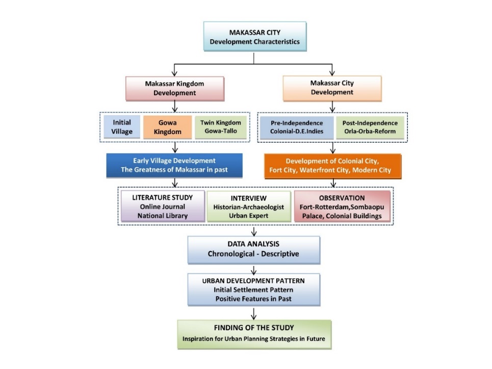
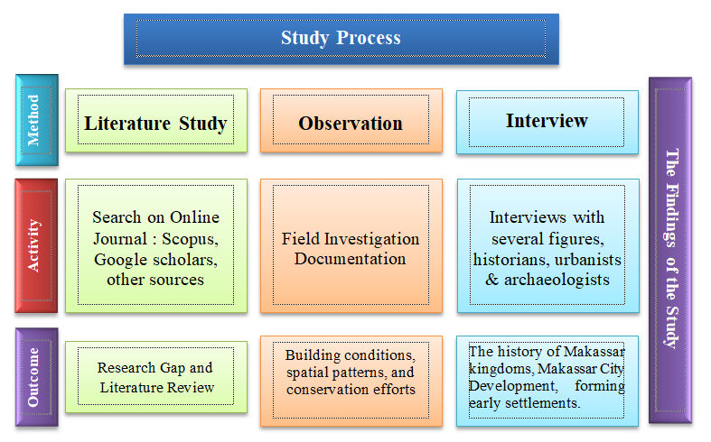

Field observations: site visits to traces of historical buildings, namely the Tamalate Palace, Fort Rotterdam, the ruins of the Somba Opu Fort, and colonial buildings in the cities of Makassar and Gowa, to match and complete the data obtained from libraries and online journals with physical evidence in the field, especially those related to building conditions, spatial patterns, and conservation efforts (see Figure 6). The development of Makassar city was analyzed from the beginning of the formation of the Gowa kingdom to the modern city today by using a descriptive and chronological approachs with consists of five development periods: Early development (Before 1670), colonialism (1670-1945), orde lama or old orde (1945-1965), orde baru or new orde (1966-1998), and reformation era (1998-Present).

Interviews with several figures, historians, archaeologists, and urbanists: head of the history laboratory of Hasanuddin University; head of the preservation of cultural heritage center of South Sulawesi; head of archeology center of South Sulawesi; head of the history department of Hasanuddin University; and head of the preservation of cultural values center of South Sulawesi (BNPB) (see Figure 6), in order to clarify and complete secondary data, particularly about the early history of forts in Makassar, the glory of the Gowa-Tallo twin kingdoms in the past, and the process of forming Makassar's early settlements. The resource persons were selected with the consideration that they understood the history of Makassar City's development, had free time, were easy to communicate with, and were also active in historical studies of the urban development.
The naming of Makassar is estimated to have existed at the time of the Gowa Kingdom, namely in the 14th century, this area was already known as Makassar, and the people were called the Makassar tribe. In the Negarakertagama book written by Mpu Prapanca in the era of Gadjah Mada (1364) the name Makassar is part of the Majapahit power, as contained in Sarga XIII and IV. The word Makassar referred to by Prapanca in the article is not a tribal name, but the name of a country, namely the land of Makassar, as is the country of Bantayan (Bantaeng), Luwuk (Luwu), Butun (Buton), Selaya (Selayar), and others (Sewang, 2005). The name Makassar was only known in the 14th century, which is listed in Desawarnana Pupuh XIV, which states that "the area east of Java that was controlled by Majapahit in the mid-14th century: Bantayan, Luwu, Makassar, Buton, Banggawi, Selayar." In Antonio Galvao's (1563) work, a statement reads "Celebes Mocassares," the famous Makassar people. Tun Sri Lanang, in his book entitled “History of Malay”, once the 19th story, there is also the name Makassar in it. Makassar is a city that has a long history, from pre-colonialism to its formation as a modern city today. Initially, Makassar was part of the territory of Gowa Kingdom (Abdullah and Achmad, 2009).
Early developmentThe history of the formation of early settlements in Makassar was formed from the concept of "Gaukang," which later gave birth to village units until the creation of the Gowa Kingdom. Before the royal period in South Sulawesi, there was a unitary settlement called Bori. Based on oral history related to community beliefs, the place that is seen as the forerunner of the first residential area is where the “Gaukang” was found. This place becomes the determining factor of where people will live and form a social group called Bori. The discoverer of the Gaukang would be the head (eldest father) of the Bori. This concept is the initial concept of early settlement in South Sulawesi (Poelinggomang, Edward L, 2004). A gaukang is an object that is considered sacred and has supernatural powers, such as wood pieces, stones, and others (Ningrum, 2018).
Initially, there were nine villages in the Gowa region, namely Tombolo, Lakiung, Saumata, Parang-parang, Data, Agangjene, Bisei, Kalili, and Sero. At the beginning of the 14th century, the nine village heads agreed to construct the Gowa Kingdom, with "Tomanurung Bainea" as King of Gowa I (1320-1345) with the title "Karaeng Sombaya ri Gowa," then passed on to his son "Tumassalangga" as King of Gowa II. During the reign of King Gowa VI (Tunatangkak Lopi), there was a division of the kingdom namely the Gowa and Tallo kingdoms, to avoid disputes between the two sons of Tunatangkak Lopi, namely Batara Gowa (King of Gowa VII) and Karaeng Loeri Sero (King of Tallo I). In 1565, King Daeng Matanre Karaeng Tumapa'risi Kallonna (King IX) reunited it into the "Kingdom of Gowa-Tallo" (Kingdom of Makassar) with the agreement of "Rua Karaeng Naserre Ata" (two kings and one people) with a power-sharing system: King Gowa as the main king and King Tallo as the "Pabbicara-Butta" (Prime Minister). The palace of Gowa Kingdom was originally located in Tamalate (Kalegowa), then moved to the Somba Opu Palace by the king of Gowa IX, but after the Somba Opu Palace was destroyed by the VOCs in 1669, the Gowa kingdom administratively moved back to the Tamalate Palace. Then, the area around the Kalegowa fort developed into the capital of the Gowa Regency.
In its subsequent development, the Gowa-Tallo Kingdom grew into a large kingdom that was influential in Eastern Indonesia, even reaching Southeast Asia (Johor, Pahang, and Patani) during the reign of King Gowa XII. The twin kingdoms of Gowa-Tallo also constructed ten fortifications along the coast for defense from the west and sea, namely: Forts of Somba Opu (1510), Sanrobone (1510), Tallo (1510), Ujung Tanah (1545), Ujung Pandang (1545), Panakukang (1546), Barobbosa, Mariso, Garassi, Barombong (1546), and two forts located on land or far from the sea, namely Kalegowa fort around the Jeneberang river; about 4 km from the edge of the ocean and Bontoala fort about 2 km west of Ujung Pandang fort (Arsyad, 2012). However, these forts were destroyed by the Dutch colonists after the signing of the Treaty of Bongaya on November 18, 1667, except for the Ujung Pandang Fort (Fort Rotterdam).
Makassar began to play a significant role in the economy of the region during the reign of King Gowa XIV "I Mangngerangi Daeng Manrabbia" (1593-1639) after appointing King Tallo VII "Karaeng Matoaya" (1593-1623) as prime minister (Tumabicara-Butta). Makassar is a trading center that connects the eastern and western regions of the archipelago. Traders sold slaves, pepper, agarwood from Malacca, and other marine products in exchange for textiles from India and porcelain from China. With fertile land conditions, the residents cultivate crops and raise livestock to meet their daily needs and also sell their agricultural products such as rice, meat, and clean water to the crew (Wirawan, 2013).
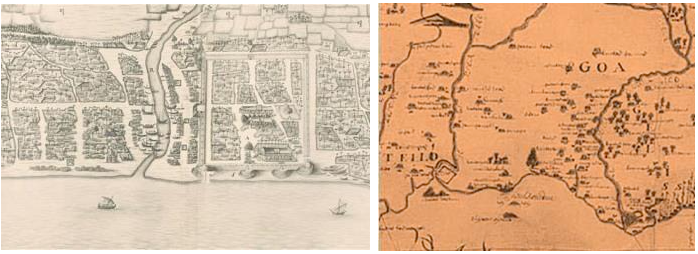
Before the Dutch arrival in Makassar or around 1600, the King Gowa XIV founded the Somba Opu Palace (see Figure 7) and around the palace, there were several foreign families including the Portuguese (Moein, 1990). After the Dutch arrived in the Makassar area, they asked permission from the kingdom of Gowa to allow them to stay to conduct trade relations with the residents. With the permission of the Gowa kingdom, they built a dormitory (loji) in the north of the Ujung Pandang fort with the name Staat Vlaardingen, and the Makassar people called it "Kampung Balanda".
The Dutch attacked the palace and the Somba OpuFort. The Somba OpuPalace was finally reduced to rubble. Although Sultan Hasanuddin and the soldiers of the Kingdom of Gowa had fought with all their might, Somba Opu Fortwas finally fortress controlled by the VOC on June 22, 1669, and this was the end of the Makassar War. The residents of Somba Opufled to Ujung Pandang, and the Dutch dignitaries occupied the Ujung PandangFort, which was captured from the hands of the Makassarese and later changed its name to Fort Rotterdam in accordance the birthplace name of Admiral C.J. Speelman. Bandar Makassar, which was initially centered in Somba Opu, then moved to Staat Vlaardingen (Ujung Pandang), then the fort of Ujung Pandang,and the surrounding villages were called "Makassar" or "Makasser" (Moein, 1990). This is the forerunner of the current city of Makassar.
Source: Wikimedia Commons; http://poestahadepok.blogspot.com/2017/12/sejarah-makassar-3-nama-nama-kampung.html
Makassar City grew out of a colonial city formed around Fort Rotterdam from the end at the 17th century. New settlements such as Vlaardingen and Kampung Baru grew in the north and south of the fort and were inhabited by people of various ethnicities; Malay, Chinese, Dutch, Buginese, Javanese, and ethnic Makassarese from Gowa and its surroundings. In 1930, there were about 3500 inhabitants from Europe, more than 15,000 Chinese, and more than 65,000 natives from various ethnicities (Pradadimara, Diaz, 2005). Among the bustling urban areas since 1600 is Bontoala. In the heyday of Makassar, Bontoala was a bustling civil city and became a peaceful residence for the cultural development of the Makassar people. Bontoala is located between the Kalegowa and Tallo Forts and has a large rice field called Kanrobosi or Karebosi (see Figure 8) (Mattulada, 1990).

Source: Mattulada (1990) and Author’s modified (2022)
By the end of the 18th century, Makassar had become a thriving port city. Physically, Makassar is still a collection of villages scattered along the coast, densely gathered near the sea and increasingly inland, and it is inhabited by a multi-ethnic population. The notes "Daily Kapitan Melayu" also inform us that several Koja (Pakistan-India) people, British people, and various other tribes from Indonesia, including Javanese, Buginese from Wajo, and others. Most members of these communities are pretty separated because the area where they live is divided into each village. Kampung Baru is to the south of Fort Rotterdam, and Kampung Melayu is to the north. The existence of Kampung Melayu (Figure 9) originated from the request of Datuk Maharaja Lela, the head of the Malays, asking the VOC to let him and his people (the Malays) leave the end of the land due to safety considerations. Therefore, the Dutch-Colonial moved the Malays to another place. The Malays built a new village by clearing the Bulekang forest. The new village was named Kampung Melayu (Patunru, 2004). According to Sutherland and Schuessler (1973), Kampung Melayu served as a buffer between the trading town and Buginese Village, where smuggling, the slave trade, and intrigue often occurred (Ceperkovic, 2005).
At the beginning of the 19th century, the position of the Dutch Colonial was replaced by the Dutch East Indies Government. Based on the agreement, the areas under the control of the Dutch Colonial were transferred under the control of the Dutch East Indies Government. In 1824, the Government of the Dutch East Indies announced the regulation of the regional government area in the State Gazette (Staatsblad) 1824 No. 31.a.: The Makassar government and subordinate regions (Gouvernement Makassar en Onderhoorigheden) are divided into five administrative areas, namely (1) Makassar port city, (2) Fort-Rotterdam (Ujung Pandang Fort), (3) Vlaardingen City, (4) Villages in around Fort Rotterdam, and (5) the islands located in front of the port city (Poelinggomang, Edward L, 2004).

Source: http://poestahadepok.blogspot.com/2017/12/sejarah-makassar-3-nama-nama-kampung.html
Since the beginning of the 20th century, Makassar has been in a Dutch East Indies-style independence vortex. The wave of western modernization began to appear at the end of the 19th century, and its development became more massive at the beginning of the 20th century. The condition of an orderly and clean settlement with various facilities: electricity, Societeit de Harmonie, dancing, night markets, canals, asphalt roads, hotels, architectural works, avant-garde, and village arrangements (Kampung Verbetering) show the symbols of a modern city.
In the early 1900s, Makassar City continued to grow along with the expansion of the city area and the increase in government bureaucratic apparatus. Three years after the Decentralisatiewet 1903 was enacted by the Governor-General Idenburg and after the conquest of local rulers, Makassar became a Gemeente, which had the right to govern its territory, and a city council (Gemeenteraad) was formed, which consisted of 13 people: 8 Dutch, 3 natives, and 2 foreign easterners, and was chaired by the Head of the Makassar Afdeling Regional Government (Het Hoofd van Plaatselijk Bestuur van de Afdeling Makassar). In 1916, this council proposed a change in the structure of the city government, and in 1918, Makassar had its first mayor (Burgemeester), who also served as chairman of the city council (Gie, 1967). Until the 1930s, Makassar City had transformed into a modern and cosmopolitan city. All the facilities made this city part of a communication and transportation network that connected it to all regions in the world (Makkelo, I., 2018). In 1938, Makassar's status changed to a municipality (Stadsgemeente) with expanded territorial and administrative rights and the number of council members to 17 people (Gie, 1967). The population of Makassar City in 1930 was 83,144 people from various indigenous, Asian, and European ethnicities, where the majority were inhabited by the Makassarese (45.24%), Buginese (19.11%), and Chinese (18.58%). More details can be seen in Table 1.
| Ethnicity | Population | |
|---|---|---|
| Total | % | |
| Makassar | 37.889 | 45,24 |
| Bugis | 15.799 | 19,11 |
| Java & Madura | 4.594 | 5,55 |
| Selayar | 1.080 | 1,30 |
| Minahasa | 844 | 1,02 |
| Buton | 515 | 0,62 |
| Banjar | 415 | 0,50 |
| Mandar | 412 | 0,49 |
| Toraja | 377 | 0,45 |
| Melayu | 132 | 0,15 |
| Ambon | 1.460 | 0,75 |
| Sunda | 217 | 0,26 |
| Eropean | 3.447 | 4,17 |
| China | 15.363 | 18,58 |
| OtherAsia | 600 | 0,75 |
| Total | 83.144 | 100 |
Source: Djunedding (2010)
The Orde Lama (Old Order) was the early development of the city (1945–1966) after Indonesia’s independence on August 17, 1945. After independence, the wave of urbanization increased sharply, especially in the period 1950–1970, which caused the population of Makassar City to increase drastically. In 1950, according to records in the Makassar Afdeling, there were 144,795 inhabitants spread across 7 areas (see Table 2), where the district of Makassar had the most densely populated villages (Chaniago, 2002), and Paeni, Gonggong et al. (1984) describe that over 50 villages are spread in four districts: Makassar, Wajo, Ujung Tanah, and Mariso districts (see Table 3).
| District/Area | Total | % |
|---|---|---|
| Makassar | 44,079 | 30,44 |
| Wajo | 28,695 | 19,82 |
| Mariso | 21,375 | 14,76 |
| Ujung Tanah | 14,688 | 10,14 |
| Spermondes | 26,76 | 18,48 |
| Kalukuang | 4,655 | 3,21 |
| Pastilon | 4,543 | 3,14 |
| Total | 144,795 | 100 |
Source: Chaniago (2002)
| Makassar | Wajo | Mariso | Ujung Tanah |
|---|---|---|---|
|
Maricayya Maradekayya Beru Pisang Ambon Kamp Gotong-Gotong Renggang Maloko Mangkura Lariangbangngi Maccini |
Bontoala Wajo Malay Pattunuang Butung Malimongang Layang Maccini Mampu Rompegading Kecak Arabic Ende Chinese Cangirak Balandaya Barayya Kawaka Tompobalang Gaddong |
Kampung Dadi Mamajang Parang Sambung Jawa Jongayya Balangboddong Kokolojia Kunjungmae Mario Panambungang Lette Mariso Mattoanging Buyang Bontorannu |
Tabarringan Ujung Tanah Pannampu Kalukuang Tallo Rappokalling Rappojawa Kalukubodoa Lakkang Gusung Pattingalloang Cambayya |
Source: Paeni, Gonggong et al. (1984)
The atmosphere of Makassar City in the decade of the 50s can be easily explored because the city is not too vast. Makassar City is located in a coastal area from the Mariso district in the south to the UjungTanah district in the north and stretches eastward to the Bontoala district. Bontomarannu is the name of a village in the south of Mariso District, which is at the mouth of the Jeneberang River. In the days of the Gowa Kingdom, this river was known as the Garassi River. At that time, there was no Tanjung Bunga; Tanjung Bunga was formed by the flow of the Jeneberang River mud for half a century (Koro and Salikki, 2006).
Table 4 shows the distribution of Makassar's population in 1961 in each district; most of the population resides in the Wajo district (33.65%) and Makassar district (33.20%); the rest is spread out in Ujung Tanah and Mariso districts. The increase in population from 1930 to 1961 was very significant; in 1930, there were only 83,144 people.
| Districts | Population | ||
|---|---|---|---|
| Male | Female | Total | |
| Makassar | 59.043 | 53.309 | 118.352 |
| Mariso | 35.010 | 33.406 | 64.416 |
| Ujung Tanah | 25.009 | 24.774 | 49.783 |
| Wajo | 60.226 | 59.718 | 119.984 |
| Total | 179.328 | 117.207 | 356.535 |
Source: BPS (1980)
Post-revolutionary upheaval forced people to seek safe havens. Migrants from remote areas tried to escape to Makassar. The large number of migrants who fled to Makassar increased the population of Makassar from 90,000 to almost 400,000. The impact of population growth has led to the growth of villages in Makassar City. The original character of Makassar began to disappear with the arrival of a multi-ethnic community (Arsyad, 2012). Even Makassar City can no longer be called the city of Makassarese speaking people because various ethnicities inhabit it. In 1951, it was recorded that the population of Makassar born in Bugis-speaking areas was around 18%, and reached 70% in 1972 (Pradadimara, Dias, 2003).
The development of villages in Ujung Pandang (Makassar) City was begun from the coast at three ports, namely Ujung Tanah Port (Paotere), Jeneberang Port, and Tanjung Pandang Port. Tanjung Pandang Port is in development and has successfully grown into a famous port. The growth of the village started in the east and south. Around 1971, the city developed to the east in the Panakkukang district. Improved infrastructure is a source of increased social and economic activities of the population. With good transportation infrastructure, the travel time of workers (laborers, builders, employees, and traders) from the village to the workplace is getting shorter (Hamid and Suprapti, 1985). Makassar's condition continues to develop and is inhabited by multi-ethnic people, so that the name Makassar was changed to Ujung Pandang in 1971. Pradadimara, Dias (2003) claims that the name change is due to the conditions of city development, where the city of Makassar is not only inhabited by the Makassar people.
The increasing population of Makassar City has made various city facilities that have been built previously unable to support the increasing population. Settlements in urban centers are generally well organized, while settlements in suburban areas are poor settlements, suchas in Panampu, Baraya, Kaluku Bodoa, Maccini, and Bara-Barayya (Arsyad, 2012). Table 5 shows the large area in each district, where the three largest districts are Biringkanaya, Tamalate, and Panakukang. At that time, these three districts developed into new centers of settlement and trade, and even now, new settlements and shophouses continue to appear.
| Districts | Area (ha) |
|---|---|
| Mariso | 182 |
| Mamajang | 225 |
| Makassar | 252 |
| Ujung Pandang | 263 |
| Wajo | 199 |
| Bontoala | 210 |
| Tallo | 583 |
| UjungTanah | 594 |
| Panakukang | 4.119 |
| Tamalate | 2.994 |
| Biringkanaya | 8.006 |
Source: Limpo, Culla et al. (1995)
The villages are often present in urban areas; more often, they are rural areas covered by the expansion of urban space (Colombijn, 1993; Hamid and Suprapti, 1985). Makassar City, inhabited by various ethnic groups scattered in several villages, has become increasingly dense. It can be seen in the development of several villages, including Panakkukang, such as in the Paropo, Rama, and Sukaria villages, where initially it was a swamp area, and rice fields developed into a new city area. Since it was expanded under Mayor HM Daeng Patompo in September 1971 and changed the name from "Makassar" to "Ujung Pandang", the development of the Makassar city settlement spread to the east and south. Initially, the economic center was around the Makassar Port and Wajo district, but now the city is developing into the central part of Makassar City around Panakkukang District (Rahman, 2017). Makassar grows as a city that does not have a characteristic because the arrangement of Makassar depends on investor interest. The current arrangement of Makassar City has obscured its identity as a historical city. Traces of the old city should be preserved but neglected and even turned into trading areas. Shophouse buildings are growing rapidly everywhere without a clear identity, so Makassar City is losing its image and history (Arsyad, 2012).
Makassar towards a world city is being socialized by the Makassar City government under Mayor of Ilham Arief Sirajuddin. The desire to make Makassar a world city emerged after Makassar City received international recognition and was included in the World Cities Summit in Singapore. To realize this, the Makassar City continues to improve from year to year. Now, the face of Makassar City physically appears to have undergone a drastic change compared to previous years. With the spirit of repeating the glory of Makassar City in the XVI century, development continues to increase. The presence of skyscrapers with 10 to 20 floors and above appears like mushrooms in the rainy season, starting a change in the face of Makassar City (Arsyad, 2012). There are more and more star hotels, and the privatization of public spaces has become a trend in itself. Rows of shophouses become the most striking appearance in urban areas without paying attention to architectural aesthetics and environmental health. Disney-type houses have been growing since 1998, offering a fantasy of serenity amidst conditions of “uncertainty and waves of anxiety.” There is more and more typical gated community housing, with a gated cluster model and guarded by security day and night (Makkelo, I., 2018). This phenomenon shows the development of Makassar City towards the world city without a clear character. Its identity from the beginning of its development has been eroded by the phenomenon of uncontrolled modern city development.
Makassar is a city or region and also the name of a tribe in South Sulawesi, which has been known since the 14th century. Makassar City is inhabited by various tribes and immigrants who are united by the culture of sipakatau (mutually humanizing or respecting each other). The early settlements in Makassar were formed from the concept of "Gaukang and Bori". which later gave birth to village units until the creation of the Gowa Kingdom (Poelinggomang, Edward L, 2004).
The existence of a city cannot be separated from the early history of its development and the process it goes through. Mumford (1967) believes that the city's development is closely related to the function of time; this shows that the city is formed from the development process of the past. So, the historical aspect plays a significant role in shaping the morphology of the city. In addition to historical aspects, physical aspects, urban planning aspects, and socio-cultural aspects also shape the city's face. Likewise, Makassar City, which was formed by the Dutch (Rahman, 2014). Its city has become increasingly important since the Dutch colonial government, where Makassar was the headquarters of its activities, both for trade and as an administrative city for the colonial government (Makkelo, I. D., 2017). It shows that the development of Makassar City in the past was strongly influenced by the political and colonial conditions at that time when the Dutch-Colonial made it a trading base in eastern Indonesia. This confirms the opinion of Short (1984) that one of the functions of the city is as a political arena or center of power activity.
Initially, Makassar was part of the territory of the Gowa Kingdom. It started when the 9th King of Gowa, Karaeng Tumaparissi Kallonna (1510-1546) was followed by the 10th King of Gowa, Karaeng Tunipallangga Ulaweng (1546-1565). By his political policy, namely Makanna ma Numa Mio (I command and you obey). The 10th King of Gowa initiated the birth and settlement of all residents in South Sulawesi in an area called Bandar Makassar, which stretched from the estuary of the Bira River (Tallo River) in the north to the estuary of the Jeneberang River in the south. Since then, the Kingdom of Gowa-Tallo has become the port of all seafarers and trade in South Sulawesi (Poelinggomang, E.L. , 2015). It shows that the development of Makassar in the past was very rapid and became a symbol of the glory of the Gowa-Tallo Kingdom. Space is a symbol of power and the formation of urban space follows the logic of power (Foucault, M. , 1980; Foucault, Michel and Miskowiec, 1986; Zhou and Xiong, 2019).
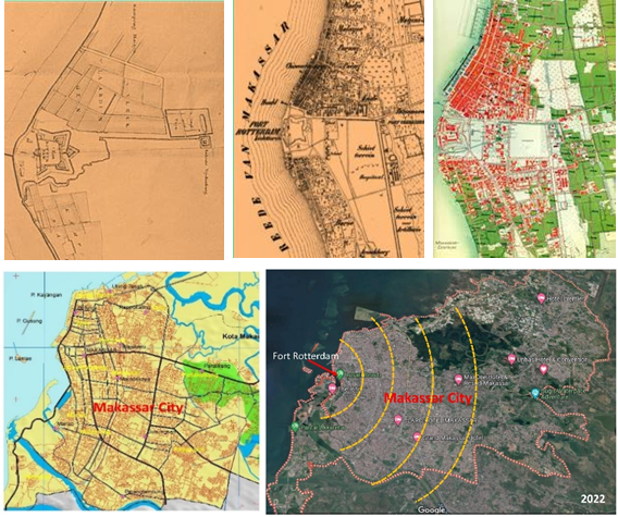
The long history of Makassar City began in the 17th-18th centuries when the Gowa Kingdom was an important port for foreign traders. Makassar's very strategic position caused foreign parties to have ambitions to control Makassar. To protect it from various unwanted things; the King of Gowa built forts around the Gowa Kingdom. When the VOC successfully overthrew Makassar under Governor-General C.J. Speelman, there was a change in the central government, initially centered in Somba Opu to Fort Rotterdam (Figure 10). This condition is identical to several cities in Indonesia, such as Jakarta, Bandung, Semarang, and Surabaya, which initially developed around ports to support Dutch Colonial trading activities at that time (Cobban, 1988; Indraprahasta and Derudder, 2019; Nurwulandari and Kurniawan, 2020). This also confirms that the coastal area, especially around the port, is developing faster than other areas (Branch, 1995; Gallion and Eisner, 1950; Hasdaniati, 2014).

Source: kitlv.nlanddetik.com
Initially, colonial settlements were built within the fort to protect against outside disturbances or sporadic attacks from the natives. Subsequent developments appeared in several settlements around the fortress of Rotterdam known as Vlaardingen. The settlements that started around the fort developed into Kampung Malayu and Kampung Baru (Figure 11). From Fort Rotterdam and these three villages, slowly but surely, the expansion of a new city began to take place. The three famous Makassar mayors made many changes to the face of the city of Makassar, namely H.M. Daeng Patompo (1965-1978), developed the Ujung Pandang Plan and Panakkukang Plan projects, gradually changing the city of Makassar and the mayor Ilham Arief Sirajuddin (2004-2009 and 2009-2014) determined to make Makassar a World City and were continued by the mayor Mohammad Ramdhan Pomanto (2014-2019 and 2021-present). It shows that the policies of the mayors of Makassar City play a very important role in changing the character of Makassar City. This confirms several previous opinions that urban development tends to follow policies formulated by higher level governments where municipal branding is more sensitive to the influence of higher level government policies (Lu, H. and De Jong, 2019).
Source: http://poestahadepok.blogspot.com/2017/12/sejarah-makassar-3-nama-nama-kampung.html
Table 6 shows the development period of Makassar from the early development to the modern era, where the development characteristics of Makassar divided into two shapes: First: the development of Makassar as a kingdom (Kingdom of Gowa-Tallo) centered at the Palace of Somba Opu. Second: the development of Makassar as a city after the collapse of the Gowa-Tallo Kingdom on 22 June 1669. After the collapse of the Gowa Kingdom, Makassar was under the control of the Dutch Colonial, which was centered in Fort-Rotterdam, in Losari Beach, and this was the forerunner to the formation of the city of Makassar today.
Initially, Makassar developed from small villages and then became a kingdom. Poelinggomang, Edward L (2004) asserts that the history of the formation of initial settlements in Makassar was derived from the concept of “Gaukang”, then developed into village units, and then developed to be a Gowa Kingdom. Before the royal era in South Sulawesi, there was a settlement community or social group called Bori. Which was a forerunner of the formation of Gowa Kingdom. This is in line with the opinion of Gallion and Eisner (1950) that metropolitan cities are formed from small towns and even initially, they are formed from small villages (Kostof, 1991).
During the Dutch Colonial Era, Makassar grew as a "colonial city" that was formed around Fort Rotterdam at the end of the 17th century, where new settlements such as Vlaardingen and Kampung Baru grew in the north and south of the fort, which was inhabited by multi-ethnic; Malay, Chinese, Dutch, Buginese, Javanese, and Makassarese. At the end of the 18th century, Makassar developed rapidly as a port city with villages scattered along the coast. This aligns with the perspective of Gallion and Eisner (1950); Branch (1995); Hasdaniati (2014) that port areas develop faster than mainland areas. At the beginning of the 19th century, the Dutch colonial government was replaced by the Dutch East Indies government, and their territory were handover to control of the Dutch East Indies government, and the end of the 19th century was the starting point for the development of western modernization.
| Period | Characteristics | Development Pattern |
|---|---|---|
|
Early Development (Before 1670) |
|
|
|
Colonialism Era (1670-1945) |
|
|
|
Orde Lama Era (Old Order) 1945-1965 |
|
|
|
Orde Baru Era (New Order) 1966-1998 |
|
|
|
Reformation Era (1998-Present) |
|
|
The development of Makassar City in the “Orde Lama” era (Old Order): It was the beginning of the development of Makassar after the independence of the Republic of Indonesia in 1945 and also the era of the Indonesian national revolution. In this era, Makassar city began to develop along with the increase in population due to urbanization, and the population in 1961 experienced a significant increase of more than 200% compared to that of 1930. Expansion and growth of villages in coastal areas with organic patterns or unplanned (Lynch, 1981). In the era of the "Orde Baru" (New Order), the population of Makassar City continued to increase sharply due to increasing urbanization, driving the expansion of the city towards the mainland east and south of Makassar City. This confirms several previous studies that urbanization has a significant effect on spatial changes and urban growth (Ashik, Mim et al., 2020; Brettell, 2000; Msuya, Moshi et al., 2021; Surya, Salim et al., 2021; Yılmaz and Terzi, 2020).
In the reformation era, Makassar City experienced rapid development and a shift in the city center, where initially the CBD area was centered around the Wajo sub-district and around the port in the western part of Makassar City. Then, it shifted to the eastern mainland in the district of Pannakkukang along with the improvement of land transportation infrastructure. The Pannakkukang area was originally a swampy area and agricultural land that was turned into a new CBD and an elite residential area. The next development is an integrated area development in the coastal city of Tanjung Bunga in the early 1990s for residential, commercial, and tourism areas, with an area of about 1,000 hectares, which is located in the southwest of Makassar City and has become a new icon of the Makassar City today. The development pattern of Makassar City in the reform era is identical to the pattern of the "Multiple Nuclei Model" (Harris and Ullman, 1945), where new CBD areas developed in the Panakukkang and Tanjung Bunga areas. Even in the 2000s, trading areas developed in the Tamalanrea and Biringkanaya districts.
The development of Makassar is divided into three important periods, namely: (1) the development of the kingdom period (kingdom city/traditional city); (2) the development of the colonial city around Fort Rotterdam after the collapse of the Gowa Kingdom; and (3) the development of Makassar towards a modern city after the independence of Indonesia, which consists of three phases: the old order, new order, and reformation eras (Table 6). In the past, Makassar’s development as a trading and port city was greatly influenced by geographical conditions in which Makassar was directly adjacent to the sea in the west, so that development of Makassar City began along the coast, which was between two major rivers, namely the Jeneberang river and the Tallo River. Furthermore, the Makassar border in the north is an inland area inhabited by the Buginese community, while the southern border is inhabited by the Makassar tribe; ships from the northern interior bring natural resource commodities to Makassar to be sold in the market; and in the western part, there are several small islands that play an important role as protection from storms and waves for boats that conduct trade in the port of Makassar.
Today, Makassar City is growing rapidly into a world city, but its blurry identity as "a historical city" has neglected historical relics and many have even been destroyed. As stated by Sairinen and Kumpulainen (2006) and Da and Xu (2016), the development of modern cities often leaves their identity because they focus more on economic factors and investors' interests. In addition, the development of Makassar City raises various urban social problems, such as the emergence of slum settlements, traffic jams, floods every year, etc. This indicates that the sustainable development strategy has not been implemented optimally, as stated by Basundoro and Madyan (2018) and Del Giudice and De Paola (2018), that many cities are growing rapidly in quantity but ignoring the principles of sustainability.
Sustainable urban development must protect cultural heritage as the main attraction and fulfill the interests of the government, tourists, and society (Liu and Shu, 2020) where historical features should be the city identity and driver of city development (Amado and Rodrigues, 2019; Sepe, 2013; Subbotin, 2020), such as several cities in the world: imperial identity in the city of London (Massey, 2007); Ching dynasty identity in Chinese cities (Lu, C. and Li, 2021). In addition, the preservation of historical values and local wisdom can contribute to reducing the impact of globalization and improving the economic sector (Coscia, Lazzari et al., 2018; Sepe, 2013). Local wisdom can provide added value and even be a fundamental factor in sustainable development. The value of local wisdom as an identity can create economic and social sustainability (Parameswara and Wulandari, 2020). Local wisdom values serve as a unifier in the heterogeneity of cultural, religious, and ethnic differences in urban areas (Diab, Pabbajah et al., 2022). Therefore, the government's role is very necessary in preserving the environment and local wisdom (Özdemir Işık and Demir, 2017). The strategy to preserve local wisdom values in the era of modernization is to instill local wisdom values and a love of culture from an early age, holding cultural festivals, promoting culture, and making culture an identity (Jamika, Barlian et al., 2023).
The development pattern of Makassar City begins in the coastal area and then develops in the mainland area. In the New Order era, the development of Makassar City grew rapidly, so that satellite cities emerged with a development pattern identical to the "Multiple Nuclei Model". The development of Makassar into a world city without a clear character is the result of the uncontrolled development of a modern city, so Makassar City loses its identity and history. In order for that to not take place continuously, a comprehensive form of city management is needed, including reviving the cultural identities of Makassar City, because the city does not only involve the physical and visual aspects of buildings but also the socio-cultural aspects of the people who live in them (Asmunandar, 2020).
The development of Makassar City cannot be separated from the glory of the twin kingdoms of Gowa Tallo in the past. At that time, Makassar developed as a big city and was known in Europe as the "City of Maritime and Trade." In addition, during the colonial period, several physical buildings and supporting facilities were established in the form of offices, educational facilities, houses, places of worship, hospitals, military buildings, and public facilities. The ancient building is an icon of the city of Makassar as a "historical city." Therefore, the cultural and historical potential of Makassar City must be protected and preserved. Historic buildings in the old city area should be protected by regional regulations governing the allotment of land and buildings in the area. This is important so that the existence of the old city area can be maintained even though the pace of urban development continues. Through historical buildings, several aspects of life can be revealed, such as the social, religious, and political aspects of society in the past. Özdemir Işık and Demir (2017) assert that planners must protect the historical-cultural characteristics of the city to improve the quality of life for citizens, so the role of the government is indispensable in preserving the environment and local wisdom. Efforts to preserve the historical heritage and local cultural identity are very important in urban regeneration (Amado and Rodrigues, 2019). Cultural heritage can contribute to people's welfare, reduce the impact of cultural globalization, and also become an incentive for sustainable economic development (Coscia, Lazzari et al., 2018; Sepe, 2013). The concept of architecture and urban development in a city must include the implementation of cultural and historical potential (Subbotin, 2020).
To avoid the tendency of city development to become increasingly chaotic or without identity, it is necessary to understand the factual conditions of the city development process by tracing the order of city life based on appreciation, aspirations, policies, and historical and socio-cultural values of the community as the meaning of the city's identity, so that the rediscovery of the city's identity as part of community life in an effort to fulfill the needs of city residents and improve the quality of a sustainable environment based on local wisdom. Thus, the expected city development is not wasteful development but city development that can meet the city development criteria described by (Laming and Rahim, 2020), function of the City Fosters a Greater Common Good.
A city's identity manifests itself in the minds of its residents, visitors, and outsiders. Metropolitan cities generally have a unique image not only because of their buildings and landscapes but also because of the culture, politics, and social conditions of their people. Studying human perception of urban space is necessary for every stakeholder in urban development, such as policymakers, local associations, and urban planners. For Lynch (1981), identity is the first of three components of environmental image; the other two are structure and meaning. Therefore, it is very important to understand the identity of a city, because as the identity of a city becomes more known, it is hoped that the order of life of its citizens will become clearer and more focused, and the quality of the city's environment can be well maintained and sustainable. If the identity of a city to be developed is not understood comprehensively, of course the development process and the lives of city residents will become increasingly uncertain, and the physical condition of the city will be chaotic, resulting in degradation of its environmental quality.
The historical city identity is necessary for the formation of local identity as a memorable area with traditional and social values as a magnet for economic and creative activities (Makkelo, I., 2018). The potential of urban visuals that come from old buildings can be input into the design process and make this potential a characteristic of a place (Zuhri, Ghozali et al., 2023). Historical values greatly influence the spatial evolution and physical form of the city (Akil, Pradadimara et al., 2022). Historical values and local wisdom become a strong identity and are different in each place, so they become fundamental factors in realizing socio-economic sustainability (Parameswara and Wulandari, 2020). Therefore, it is hoped that the positive findings from this study can be an inspiration for city planners and local governments in developing a better Makassar city in the future based on local and sustainable wisdom in accordance with its identity, which has grown since the beginning of its development.
Makassar is one of the four main growth centers in Indonesia, along with Medan, Jakarta, and Surabaya. As a metropolitan city, Makassar City's problems have become so complex and comprehensive that conventional solutions can no longer solve existing problems; more innovative and sustainable solutions are needed. In the beginning, the development of Makassar was indentical with that of the three cities, where it initially grew as a royal city, then developed as a colonial city, and after Indonesian independence, they developed towards modern cities according to their respective potentials. In their subsequent development, most cities in Indonesia were able to maintain their historical values as their city image, but Makassar's development towards becoming a world city actually blurred its identity as a historical city. Several previous study results explain that historical city identity is necessary for the formation of local identity as a magnet for the growth of economic activity.
The study’s findings are: (1) the history of the formation of early settlements in Makassar was formed by the concept of "Gaukang and Bori" which later gave birth to village units until the creation of the Kingdom of Gowa. "Gaukang" is an object that is considered sacred and has supernatural powers, while "Bori" is an early settlement unit. (2) The development of Makassar City consists of three essential phases: the kingdom era (kingdom city/traditional city); the colonial city or fort city after the collapse of the Gowa Kingdom; and the development of Makassar towards a modern city after Indonesia's independence. (3) In the past, the development of Makassar City was influenced by the world's spice trade lines, so Makassar became a port city and a spice trade center in the eastern part. In the modern era, the development of Makassar city is dominantly influenced by the increase in urbanization and the trade industry, where Makassar is the center of economic growth in the eastern part. (4) Since ancient times, Makassar has been inhabited by various ethnic groups united by the "Sipakatau" culture. "Sipakatau" is an attitude of mutual respect or appreciation. (5). The development pattern of Makassar City begins in the coastal area and then develops in the mainland area following the potential areas of new trade areas, educational areas, and road facility improvements.
Today, Makassar is developing toward a world city under the Makassar city government's policy, but unfortunately, these changes obscure the image of Makassar City as a historical city because of uncontrolled development and more focus on investors' interests; various urban problems arise, such as congestion, flooding, crime, slums, and the urban sprawl phenomenon. Therefore, a sustainable urban development strategy is needed by integrating the preservation of cultural heritage with the management of trade areas based on local wisdom.
This initial study only describes the development of Makassar City briefly due to limited data sources, so an in-depth and more detailed study is needed in the future involving more historical experts and data sources, and it is also necessary to analyze the land use change patterns and their implications for sustainable development. The findings of this study can provide insight to urban planners and governments in determining future urban development strategies.
Conceptualization, I.A and M.R.; methodology, I.A and M.R; literature study and observation, I.A and M.R; Interview, I.A; writing—original draft preparation, I.A., and M.R.; writing—review and editing, M.R.; All authors have read and agreed to the published version of the manuscript.
The authors declare that they have no conflicts of interest regarding the publication of the paper.
We would like to express our sincere gratitude and appreciation to the Ministry of Education, Culture, Research, and Technology, the Republic of Indonesia, for providing the research fund.