Abstract
The Xicang Bazaar plays a crucial role in the everyday lives of the residents of Xi’an and acts as a major center for cultural and social events. As vendors set up informal activities in public spaces, there is frequent disarray in the bazaar. This study examines the relationship between disorder in Xicang Bazaar and its adjacent streets based on a concise overview of the distinctive features of the bazaar and its challenges. The study employed Ospider to analyze the discrepancies in business structures between Xicang and neighboring regions and Depthmap to analyze the spatial integration of the road network. The examination of the accessibility and centrality of different roadways revealed differences between the northern and southern areas of Xicang. Finally, this study utilized the D/H ratio of roads to assess the cross-sectional layouts of the sample roadways. These findings indicate that congestion plays a significant role in restricting urban development in the Xicang region. The substantial disparities between the northern and southern portions of the area are principally attributable to the coexistence of Hui and Han ethnic groups in the Xicang region. This study also highlights the development of a bazaar through a bottom-up mechanism as a space characterized by “informality.” Hence, this study is critical as a reference for revitalization and restoration measures for metropolitan areas.
Introduction
In this era of rapid urbanization, humankind has caused irreversible damage to many urban areas and their crucial architectural heritage features, creating significant difficulties in preserving and restoring urban architectural history. Japanese researchers have analyzed the reconstruction of areas affected by earthquakes and the actions of architects (Li and Neill, 2018). Researchers in Indonesia utilized ArcGIS to assess grid-based surfaces and proposed a methodology for precisely identifying street sellers (Akil, Yudono et al., 2023). These studies share a common theme with this paper.
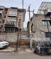
The Xicang District, located in the Lianhu area of Xi’an, is the epitome of the historic urban area of Xi’an and serves as the fundamental basis for the Xicang Bazaar. The presence of bazaar vendors in stalls’ urban public spaces can result in their exclusion from the city. Xicang Bazaar faces multiple issues, including reduced efficiency, traffic congestion, uneven development of metropolitan areas, environmental deterioration, and insufficient infrastructure.
This study thoroughly analyzed the roles and characteristics of Xicang Bazaar to understand its current conditions and identify its issues. These findings provide the basis for future government reconstruction efforts. We initially employed Ospider to examine the discrepancies in business frameworks between Xicang and its adjacent regions, specifically emphasizing the transportation infrastructure, and the Depthmap tool to analyze the spatial integration of the road network, explicitly comparing the accessibility and centrality of different roadways. This investigation revealed significant differences between the northern and southern parts of Xicang. Finally, we used the D/H ratio of roads to assess the cross-sectional structure of sample roadways. These results indicate that stalls significantly limit urban renovations in Xicang. Furthermore, the disparity in lifestyle between the inhabitants of the northern and southern regions of Xicang, characterized by the cohabitation of Hui and Han ethnic groups, is another significant factor that contributes to this imbalance.
This study also highlights the development of a bazaar through a bottom-up mechanism as a space characterized by “informality,” with extensive inherent relationships between urban blocks. Hence, this study provides critical information for the revitalization and restoration of metropolitan areas (Hillier and Hanson, 1989; Roever and Skinner, 2016).
The study findings reveal the specific attributes of disorderliness in the Xicang District, as outlined below:
(1) Road arrangements in Xicang must be better organized. Traditionally, the establishment of Xicang Bazaar did not involve deliberate planning or design, leading to a deficiency in the overall logical arrangement of roads. The lack of synchronization between urban development processes and infrastructure building has resulted in road planning and management issues within the bazaar.
(2) Religious disparities exist between northern and southern Xicang. The disorderliness of residential spaces in Xicang is evident in the proliferation of densely self-built dwellings, which is the primary characteristic of multi-ethnic mixed residential areas. The Hui inhabit the southern part of Xicang and adhere to the Islamic faith. They habitually live near mosques, thereby fostering the creation of relatively insular community spaces. Conversely, the Han population primarily occupies the northern region of Xicang, leading to discernible differences in architectural styles between the northern and southern areas and reflecting the unique cultural and lifestyle practices of each ethnic group.
Methodology
Study area
Xicang Bazaar is located in the Lianhu District of Xi’an City and has historically served as the city’s central hub. This area boasts of numerous palaces, temples, city walls, and other architectural heritage sites. This study focuses on the Xicang Bazaar area, which encompasses commercial trading spaces and other functions, including marketplaces and residential, public, and road areas. The research area comprises the territory bordered by Miaohou Street to the south, Beiguangji Street to the east, Sajinqiao Road to the west, and Laowu Lane to the north, covering an approximate area of 320,000 square meters (Figure 1).
Research methods
First, the study employed Ospider software to examine the disparities in business structures in Xicang District and its environs. The research findings suggest a specific association between these variations and the road infrastructure.
This study further employed Depthmap to conduct road axial analysis and visually examine the correlation between pedestrian flow density, commercial density, and road accessibility to identify the factors contributing to low spatial integration and propose future strategies for improving spatial integration (Roozkhosh, Molavi et al., 2022; Zaleckis, Chmielewski et al., 2022).
The study concluded with a comparison of notable variations in spatial integration across distinct regions of Xicang and an explanation of these variations. These factors also indicate the distinct spatial attributes of Xicang District (Figure 2).
POI analysis
POI represents “Point of Interest,” representing spatial data characterized by coordinates, category information, accessibility, and other attribute data to accurately reflect the geographical characteristics of the spatial distribution of the research subjects. Visual analysis using Ospider allows for precise observation of the distribution quantity and density of functions such as transportation, leisure, and shopping near Xicang. The developmental status of any desired function in this area can thereby be ascertained.
Analysis of road integration
In recent years, spatial syntax has gained significant attention as a research area, and has become an approach taken by numerous scholars (Meziani and AlRifai, 2023). Spatial syntax is a quantitative approach used to explain the layout of places where humans live. Its goal is to examine the organization of space and the social ties among humans. To evaluate the degree of integration in intricate environments, we employed Depthmap for axial analysis and assigned colors to the findings depending on the calculated values. In this color scheme, red signifies the highest value and blue signifies the lowest value (Tutuko, Bonifacius et al., 2021).
When analyzing the integration of a street network, we selected one street as the root node and determined its connections with other streets in order to conduct a thorough assessment of the complete street network, and employed colorization to visually represent the level of integration, creating an analytical map that depicts the integration of the street network.
External space theory
Yoshinobu Ashihara authored two publications, The Aesthetics of Streets and Exterior Space Design, focusing on spatial design strategies from both visual and perceptual viewpoints. He proposes that visual perception is the primary way individuals perceive urban spatial surroundings, and that spatial form directly impacts people’s psychological perceptions and behaviors. Ashihara examined the visual effects of roadways and regarded the ratio of road width to the height of buildings along roads as a significant measure for assessing urban spatial interactions. When the ratio of D to H is less than 1, the space was packed, and as the D/H ratio increases, the enclosed spaces become more expansive. The objective of this study was to assess exterior space through D/H values to quantitatively investigate the spatial perception of roads in Xicang Bazaar.
Data and preprocessing
Regional vitality assessment
First, Ospider was used to analyze the differences in the distributions of significant business types in Xicang District and its surrounding areas (Figure 3) (Alves, 2021).
Subsequently, GIS was used to extract the POI. This conversion of POI data into polygonal data allows the overall vitality of an area to be assessed (Figure 4) (Nurhayati, 2020).
Road Integration
Vendors organize the bazaar themselves every Thursday and Sunday. This study compared the pedestrian flows on bazaar and non-bazaar days within the same week (Figure 5 and エラー! 参照元が見つかりません。) (Handy, Butler et al., 2003).
Employing spatial syntax, we selected the Xicang area and its surroundings as the study area and conducted an axial analysis using Depthmap. High integration is indicated in red, low integration in blue. High integration indicates vital road accessibility, whereas low integration indicates weak road accessibility (Baran, Rodríguez et al., 2008). After calculating the global integration, we further defined the local integration levels as 3, 5, 7, 9, and 11 and computed the local integration levels ( Figure 7).
Road Integration
The D/H ratio of road width to adjacent building height is an essential indicator of the urban spatial interface. When D/H < 1, the space appears crowded, whereas the larger the D/H, the more spacious the enclosed area, indicating better road accessibility(Table 1).
Table 1. Sample Road’s data


Note: ① Roads denoted with an asterisk (*) are located in the southern region.
② Select the more considerable value between D/H1 and D/H2 as the evaluation criterion for this road's spatial perception.
Table 2. Displays the D/H values of the nine road samples
| Sample
|
1
|
2
|
3
|
4
|
5
|
6
|
7
|
8
|
9
|
| D/H |
1.75 |
0.75 |
0.8 |
0.6 |
1.75 |
0.8 |
0.7 |
0.6 |
1.2 |
Stalls and Roads are Main Factors in Xincang
The road system contributes to the underdevelopment of Xicang
This study used Ospider to analyze business formats in the Xicang area and its neighboring regions (Figure 3), unveiling possibilities for enhancement within transportation dynamics. Furthermore, notable disparities were identified in key indicators such as shopping, dining, finance, and healthcare, with respect to transportation. The transportation conditions in the Xicang area are regularly considerably low-vitality (Figure 4), showing the severity of the transportation challenges in that area (Desti, Tarmedi et al., 2020).
Research on POI, focusing on the four lanes of Xicang, indicates that commercial distribution in Xicang continues to exhibit the characteristics of bazaar culture. Xicang Bazaar was organically formed over time by sellers and residents without planning or design. As a result, the road layout needs overall organization and rationale (Tweed and Sutherland, 2007). Stalls in the bazaar occupy road space and pedestrians shopping on foot obstruct road traffic, leading to congestion and traffic chaos. Moreover, rapid urban development and population growth have resulted in disordered roads in Xicang. With the rapid increase in demand, urban planning and infrastructure construction have failed to keep pace, leading to problems of road planning and management within the bazaar. In addition to contemporary stores along the main roads on the periphery, Xicang’s core is predominantly filled with booths, which serve as the principal form of commerce.
Notably, Xicang’s backwardness is not confined to particular regions, but encompasses the entire area. The ancient city area of Xicang exhibits notable disparities in road networks compared with the surrounding new city. Consequently, the transition to contemporary urban operation modes has proved challenging, leading to a diminished vitality circle in the city center.
Stalls are the primary cause of the low integration
By comparing a heat map of the region from satellite imagery (Figure 5 and エラー! 参照元が見つかりません。), it is evident that pedestrian activity is significantly higher on bazaar days than on non-bazaar days. Road accessibility is significantly compromised on bazaar days, which corresponds to dense crowding.
This study employed Depthmap to conduct an axis analysis of the road system (Figure 7), visually depicting the correlations among pedestrian flow density, commercial density, and road accessibility. Miaohou Street, Sajinqiao Road, Beiguangji Street, and the southern lanes of Xicang have been identified as highly accessible and centrally located roadways that attract numerous pedestrians. Most of these routes are situated in the southern part of the area, whereas the northern side is distinguished by the clustering of bazaar stalls. The research findings suggest that road accessibility is more limited in northern regions. Hence, the leading cause of limited spatial integration is the market booths on both sides of the road.
The significant correlation between stalls and road system
This study evaluates the cross-sectional configuration of roadways by analyzing D/H values and correlates the perception of roads with the construction along them. The D/H values of the nine sample roads indicate that Miaohou Street and Beiguangji Street, which have ratios greater than 1, are situated in the southern section of the site ( Table 1 and Table 2). The findings from the prior axial analysis conducted with Depthmap align with this observation, suggesting that road accessibility is worse in the northern region than in the southern region (Koohsari, Sugiyama et al., 2016; Zhou, Zhao et al., 2017).
Cultural Characteristics of Xicang
The Bazaar Culture of Xicang
The commercial distribution in Xicang maintains the traits of bazaar culture, primarily concentrated on the four alleyways of Xicang (Figure 8). Stalls have had a significant influence on Xicang’s urban development. Xicang’s bazaar culture originated in the Ming and Qing dynasties. Since its establishment as a governmental granary, Xicang has evolved into a vibrant bazaar specializing in the trade of insects, birds, flowers, and other commodities. Over time, Xicang has accumulated rich cultural heritage.

The establishment of Xicang as an official granary throughout the Ming and Qing dynasties was the basis of its bazaar culture. As a granary, it naturally drew the attention of numerous traders and crowds. The cumulative presence of these individuals facilitated the establishment of the Xicang Bazaar. During the Qing era, aristocrats developed a strong interest in insect breeding and birdkeeping. They regularly received salaries near Xicang, leading to the emergence of vendors specializing in selling flowers, birds, fish, and insects nearby. During the Republican era, the bazaar culture of Xicang reached its zenith. The service targets of Xicang Bazaar expanded from the original noble class to all enthusiasts, transforming the bazaar into a hub for people to interact and mingle, ultimately giving rise to a dynamic community.
However, with the establishment of the People’s Republic of China, the imposition of restrictions on capitalist activities led to the complete elimination of bazaar culture in Xicang. The traders had to cease operations, resulting in the gradual disappearance of the vibrant ambiance of Xicang, which was replaced by an economic framework centered around common ownership. With the implementation of the reform and opening-up policy in 1978, Xicang’s bazaar culture was restored and integrated with new functions (Figure 9).
The Bazaar Culture of Xicang
The presence of multiple ethnic groups in the region is a crucial factor contributing to the notable disparities between the northern and southern areas of Xicang.
The Hui people adhere to the Islamic faith. Following the decline of Chang’an City in the late Tang Dynasty, the Xicang area transformed from an administrative district to a residential neighborhood, attracting a substantial population of Hui residents. This transition resulted in significant alterations in the physical layout and caused functional changes. The Hui mosques in Xicang adhere to the conventional Chinese courtyard design, which features primary buildings constructed using wooden frames. Nevertheless, the ornamental designs and paintings inside retain the distinctive features of Arabic architecture. The amalgamation of Hui and Han ethnic religious cultures has resulted in a unique and varied panorama in Xicang.
Residential Culture of Xicang
Islamic residential culture is prominent in Xicang. The proximity of houses to the mosque among the Hui people suggests a deliberate choice to enable easy engagement in religious practices and to immediately heed the mosque’s call. This close living arrangement fosters a strong bond between the Hui people and their religious groups, creating a cohesive religious way of life. The phrase “Doing business near the Fang” indicates that the Hui people depend on it for economic transactions. They have established stores, stalls, and family workshops within and nearby the bazaar and participated in diverse commercial endeavors. The Hui depend on commercial resources and movements in the bazaar area to engage and collaborate with individuals from other ethnic backgrounds and religions, forming a distinctive Hui commercial culture.
Furthermore, the residential culture of “residing close to the mosque and engaging in commerce near the bazaar” also impacts the physical arrangement and social progress of Xicang. Hui populations frequently establish distinct urban districts characterized by mosques and bazaars at their centers, flanked by residential neighborhoods, business districts, and cultural zones. The cultural phenomena of the Hui communities influence how they organize spatially and socially, thereby enhancing the city’s cultural richness and historical history (Wang, Zhang et al., 2023).

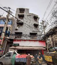
As the southern region of Xicang is home to most of the local Hui people, this area’s architectural landscape consists primarily of low-rise Hui-style residences. Conversely, the Han ethnic group mainly resides in the northern region of Xicang, leading to a higher concentration of multi-story residential buildings (Figure 10 ). Similarly, the distinctions in the ways of life between the Hui and Han people residing in the northern and southern regions impacted the road system during its construction (Table 3 ).
Conclusion
This study examined the geographical characteristics of the road network in Xicang by employing regional vitality evaluation, spatial syntactic analysis, and the D/H value derived from the external space theory, reaching the following conclusions:
The road system faces several challenges. Conventional roadways and lane layouts require enhancements to meet the demands of modern urban transportation (Dandan, Wei et al., 2007). Ancient urban planning and architectural styles accounted for the rapid and extensive use of modern vehicles. A limited level of modernization leads to traffic congestion and disorder.
Religious beliefs pose a challenge in domestic spaces. In Xicang, the Hui ethnic group inhabits more than 60 percent of residential areas. Hui communities comprise a wide range of house types that have frequently undergone renovations during different historical epochs, leading to a diverse array of architectural styles and characteristics. Nevertheless, due to constraints and specifications throughout the remodeling process, homes constructed by individuals need more functionality and spatial arrangements, as they fall short of contemporary residential demands and community service criteria.
Contradictions arise when it comes to the development of bazaars, the exploitation and administration of urban public spaces, the integration of urban planning, and the improvement of spaces and the environment (Warlina, Yusuf et al., 2021). As cities grow and develop, urban planning and construction frequently alter the original design and purpose of bazaars, resulting in the loss and destruction of their historical, cultural, and traditional characteristics. Furthermore, as the urban economy advances and market competitiveness intensifies, traditional bazaars are being challenged by commercial areas and shopping malls, leading to operational challenges and decreased market share. Moreover, as urbanization accelerates and urban space becomes limited, traditional bazaars face significant threats to their public spaces and social functions. Urban design and construction frequently exclude bazaars, which gradually degrades their social and cultural roles (Widjajanti, 2016).
This study examined the physical and cultural aspects of the Xicang Bazaar. The presence of a bazaar culture ensures the preservation of the local community and decreases expenses associated with daily life. These findings have substantial implications for enhancing our understanding of the evolution of the Xicang community and for providing guidance for community development.
This study examined the physical aspects of Xicang, whereas future research should investigate its intangible components. The research plan aims to integrate the primary requirements of the Xicang area to propose a comprehensive index model to assess its value. This model encompasses various dimensions, such as the cultural value of the local bazaar, historical significance of Xicang, social fairness value, and ecological benefits.
Author Contributions
Conceptualization, Zhan jingyi, and Li Ming.; methodology, Zhan jingyi; software,Zhan jingyi; investigation, Zhan jingyi; resources, Zhan jingyi.; data Zhan jingyi; writing—original draft preparation, Zhan jingyi; writing—review and editing, Zhan jingyi; supervision, Zhan jingyi, and Li Ming. All authors have read and agreed to the published version of the manuscript.
Ethics Declaration
The authors declare that they have no conflicts of interest regarding the publication of the paper.
Acknowledgments
The authors would like to express their gratitude for the cooperation of the Xi'an Lianhu District Neighborhood Committee and the local residents of Xicang. The authors would like to thank Editage for English language editing.
References
- Akil, A., Yudono, A., et al. (2023). "Suitable Potential Locations for Street Vendors in Makassar City, Indonesia". International Review for Spatial Planning and Sustainable Development, 11(3), 152-171. doi: https://doi.org/10.14246/irspsd.11.3_152.
- Alves, G. (2021). "Slum Growth in Brazilian Cities". Journal of Urban Economics, 122, 103327. doi: https://doi.org/10.1016/j.jue.2021.103327.
- Baran , P. K., Rodríguez , D. A., et al. (2008). "Space Syntax and Walking in a New Urbanist and Suburban Neighbourhoods". Journal of Urban Design, 13(1), 5-28. doi: https://doi.org/10.1080/13574800701803498.
- Dandan, T., Wei, W., et al. (2007). "Research on Methods of Assessing Pedestrian Level of Service for Sidewalk". Journal of Transportation Systems Engineering and Information Technology, 7(5), 74-79. doi: https://doi.org/10.1016/S1570-6672(07)60041-5.
- Desti, I., Tarmedi, E., et al. (2020). "The Implementation of Street Vendors Regulation Policy in Developing Their Social Order in Majalaya Area of Bandung Regency". International Journal Pedagogy of Social Studies, 5(1), 1-8. doi: https://doi.org/10.17509/ijposs.v5i1.25912.
- Handy, S., Butler, K., et al. (2003). Planning for Street Connectivity-Getting from Here to There, American Planning Association. Planning Advisory Service, Chicago.
- Hillier, B. and Hanson, J. (1989). The Social Logic of Space. Cambridge university press.
- Koohsari , M. J., Sugiyama, T., et al. (2016). "Street Network Measures and Adults' Walking for Transport: Application of Space Syntax". Health and place, 38, 89-95. doi: https://doi.org/10.1016/j.healthplace.2015.12.009.
- Li, M. and Neill , D. R. (2018). "Activities and Roles Played by Architects in the Reconstruction of Hiroshima after Its Atomic Bombing". International Review for Spatial Planning and Sustainable Development, 6(1), 53-78. doi: https://doi.org/10.14246/irspsd.6A.1_53.
- Meziani, R. and AlRifai, D. (2023). "Comparative Analysis of Yas Island Master Plans between 2020 and 2030 Using Space Syntax". International Review for Spatial Planning and Sustainable Development, 11(3), 44-62. doi: https://doi.org/10.14246/irspsd.11.3_44.
- Nurhayati, C. (2020). "Social Development in the Urban Informal Sector: A Case Study of Street Vendors in Pasar Minggu, Jakarta". MASYARAKAT: Jurnal Sosiologi, 25(1). doi: https://doi.org/10.7454/mjs.v25i1.10948.
- Roever, S. and Skinner, C. (2016). "Street Vendors and Cities". Environment and Urbanization, 28(2), 359-374. doi: https://doi.org/10.1177/0956247816653898.
- Roozkhosh, F., Molavi, M., et al. (2022). "Accessibility, Walkability, Mixed Land Uses: Analyzing Diverse Districts Based on Space Syntax Theory". International Review for Spatial Planning and Sustainable Development, 10(4), 223-239. doi: https://doi.org/10.14246/irspsd.10.4_223.
- Tutuko, P., Bonifacius, N., et al. (2021). "The Spatial Pattern of a Kampong Area in Malang City Using a Space Syntax Approach Study on Depth Calculation and Connectivity Using Depthmapx". International Review for Spatial Planning and Sustainable Development, 9(4), 102-115. doi: https://doi.org/10.14246/irspsd.9.4_102.
- Tweed, C. and Sutherland, M. (2007). "Built Cultural Heritage and Sustainable Urban Development". Landscape and urban planning, 83(1), 62-69. doi: https://doi.org/10.1016/j.landurbplan.2007.05.008.
- Wang, S., Zhang, L., et al. (2023). "Determining How Historical Sites Create Value an Empirical Study on the Restorative Value of Two Pagoda Courtyards in Xi'an, China". International Review for Spatial Planning and Sustainable Development, 11(2), 150-167. doi: https://doi.org/10.14246/irspsd.11.2_150.
- Warlina, L., Yusuf, M., et al. (2021). "Planning for Relocation Area of Street Food Vendor in Bandung City". International Journal of Design, 1, 37-42. doi: https://doi.org/10.34010/injudes.v1i1.4831.
- Widjajanti, R. (2016). "The Space Utilization by Street Vendors Based on the Location Characteristics in the Education Area of Tembalang, Semarang". Procedia-Social and Behavioral Sciences, 227, 186-193. doi: https://doi.org/10.1016/j.sbspro.2016.06.061.
- Zaleckis, K., Chmielewski, S., et al. (2022). "Walkability Compass—a Space Syntax Solution for Comparative Studies". Sustainability, 14(4), 2033. doi: https://doi.org/10.3390/su14042033.
- Zhou, T., Zhao, R., et al. (2017). "Factors Influencing Land Development and Redevelopment During China’s Rapid Urbanization: Evidence from Haikou City, 2003–2016". Sustainability, 9(11), 2011. doi: https://doi.org/10.3390/su9112011.