Abstract
Small towns serve as crucial carriers for China's new urbanization and the integrated development of urban and rural areas. Investigating their spatial distribution characteristics and influencing factors is of great significance for optimizing the regional spatial pattern of small towns. As a typical mountain-sea interaction zone along the eastern coast of China, the distribution of small towns in Fujian Province is profoundly influenced by the spatial pattern of mountains and seas. This study employs kernel density analysis, standard deviation ellipse, nearest neighbor distance method, and geographical detector models to reveal the spatial distribution characteristics of small towns and their influencing factors. The results indicate that the spatial distribution exhibits a remarkable river-to-sea characteristic, with an overall "northeast-southwest" orientation. Three densely populated areas are formed along the coast, while inland areas are primarily distributed along rivers, presenting a "dense along the coast and sparse in the interior" pattern. The highest-density contiguous areas are concentrated in the mountain-sea junction zone (within 50 kilometers from the coastline), reflecting the significant driving effect of mountain-sea synergy. Geographical detector analysis reveals that the spatial distribution is predominantly influenced by population density (q=0.587) and slope (q=0.413), with strong nonlinear and two-factor interactions with elevation, forested area, and road network density. These findings provide a scientific basis for optimizing small town layouts in Fujian and offer methodological and theoretical support for similar mountain-sea regions.
Introduction
Small towns are transitional settlements between the city and the countryside, usually including established towns and county towns. As an important node linking cities and villages, small towns play a key role in the spillover of urban functions to villages and the transfer of rural population to cities, and are an important carrier of China's new urbanization and urban-rural integration development strategy. As of 2022, there are 28,850 townships (excluding soums and ethnic townships) in China, which are widely distributed in various regions. However, due to differences in topography and landscape, economic development level and resource endowment, the spatial distribution pattern of small towns shows significant regional differentiation characteristics. Uncovering the spatial differentiation patterns and formation mechanisms of small towns in different regions is of great theoretical and practical value for optimizing the spatial layout of the national territory, promoting the implementation of the new urbanization strategy and facilitating the sustainable development of the region.
The study shows that the spatial evolution of small towns is characterized by significant geographic differentiation, and its scale distribution pattern is influenced by both natural geographic elements and humanistic and economic factors. The far-reaching influence of the complex geographic pattern on the spatial distribution of small towns is reflected in multiple dimensions such as location selection, spatial pattern, transportation network construction and development potential assessment (Basirat and Arbab, 2022). For example, an increase in topographic relief exacerbates the spatial polarization effect (Wang, Y., Sun et al., 2021); natural environmental elements such as rivers, vegetation, and elevation have a significant effect on urban spatial distribution, and this effect increases with the rise of urban grade (Zhang, Jiaqi, Chen et al., 2018). In Spain, the mountain-dominated topography leads to the concentration of population towards the capital city of Madrid and the coastal plains (Nieto Masot, Cardenas Alonso et al., 2020); in Tanzania, the topographic pattern of high northwest and low southeast makes the distribution of cities show a significant coastal lowland directionality (Zhang, Jiaqi, Chen et al., 2018).
From the perspective of topography and geomorphology, the topography of China's regions is complex and diverse, including types of mountains, plateaus, basins, hills and plains. Among them, the southeastern coastal provinces of Fujian and Zhejiang have a unique “mountain-sea spatial pattern”-a complex topographic system consisting of mountains, hills, plains, coastlines, islands, and seas-which profoundly influences the spatial distribution pattern of regional cities and towns. Exploring the influence of geographic and human factors on the spatial distribution of small towns under the mountain-sea spatial pattern has unique theoretical and practical significance. Theoretically, it helps to deepen the understanding of how specific geographic environments shape the development paths and patterns of small towns in developed regions along the eastern coast of China; practically, the relevant research results can provide scientific basis and practical guidance for regional planning, resource allocation, ecological environmental protection, and the promotion of sustainable development of towns and cities along the eastern coast of China.
The overall pattern of small towns in China is characterized by “sparse in the northwest and dense in the southeast”, with the dense areas concentrated in the North China Plain and the middle and lower reaches of the Yangtze River, while the northwestern region is characterized by complex and diverse topography, and the small towns are relatively sparse (Wang, X., Qi et al., 2020). In the eastern coastal area, the distribution of small towns is closely related to the water, forming a dual-axis pattern of “along the river and along the sea”. The spatial pattern of these towns is mostly in the shape of a belt, with ports and terminals as the core development nodes, but they also face the challenges of flooding and ecological protection (Chen, Li et al., 2006; Ma and Li, 2022; Wen, Wang et al., 2021). Small towns in the gully area of the Loess Plateau are mainly distributed in the area with an elevation of 1100-1400 m and a slope of 0°~5°, i.e., the more intact loess or river channel area, and the spatial distribution of towns and cities tends to be characterized by water and transportation directionality (Liu, L. and Ren, 2018).
Fujian is a typical province with a spatial pattern of mountains and seas along the eastern coast of China, and its urban population is clustered in the coastal as well as inland river valleys and plains areas (Cheng, J., Zhang et al., 2024; Cheng, R., Chen et al., 2019). The geomorphological features of its mountain and sea pattern are remarkable: the coastline is long (3,752 km), complex and fragmented, forming headlands, bays, peninsulas, and islands, and relatively rich in seaport resources; the internal topography is dominated by mountains and hills, with three major mountain ranges, Wuyi Mountain Range in the north, Daiyun Mountains in the center, and Jiufeng Mountain Range in the east, with a mountainous proportion of more than 70%; the rivers in the area are short, the plains are narrow, and the rivers originating in the mountainous areas are short and fast-flowing. The rivers in the region are short and narrow, and the rivers originating from the mountains are short and fast, with estuarine alluvial plains (e.g., Zhangzhou Plain, Fuzhou Plain, Xinghua Plain, and Quanzhou Plain) formed in the downstream; and the overall ecological transition in the region is remarkable, with unique vertical gradient ecosystems at the junction of the mountains and the sea (Zhang, Z., Tang et al., 2022). The study of the spatial pattern of small towns in Fujian Province can provide an important reference for revealing the complex interactions between geography and economic and social activities in the formation of towns and cities in China's mountain and sea intersection areas.
This paper takes Fujian Province as the study area, focuses on the spatial distribution of small towns and their influencing factors under the mountain-sea spatial pattern, and adopts analytical methods such as the closest distance method, the standard deviation ellipse and the kernel density to analyze the spatial distribution characteristics of small towns under the mountain-sea spatial pattern in terms of the distribution pattern of small towns, the overall distribution of the center of gravity, the distribution of the direction, and the focusing situation. At the same time, based on the geodetic detector model, it reveals the dominant influencing factors of the spatial distribution of small towns under the mountain-sea pattern and their interaction mechanisms. By exploring the distribution pattern of small towns, we aim to provide scientific basis for the planning and development of small towns in the eastern China mountain and sea area, and enrich the theoretical framework for the study of small towns under the complex geospatial pattern.
Research Framework and Research Methods
Research framework
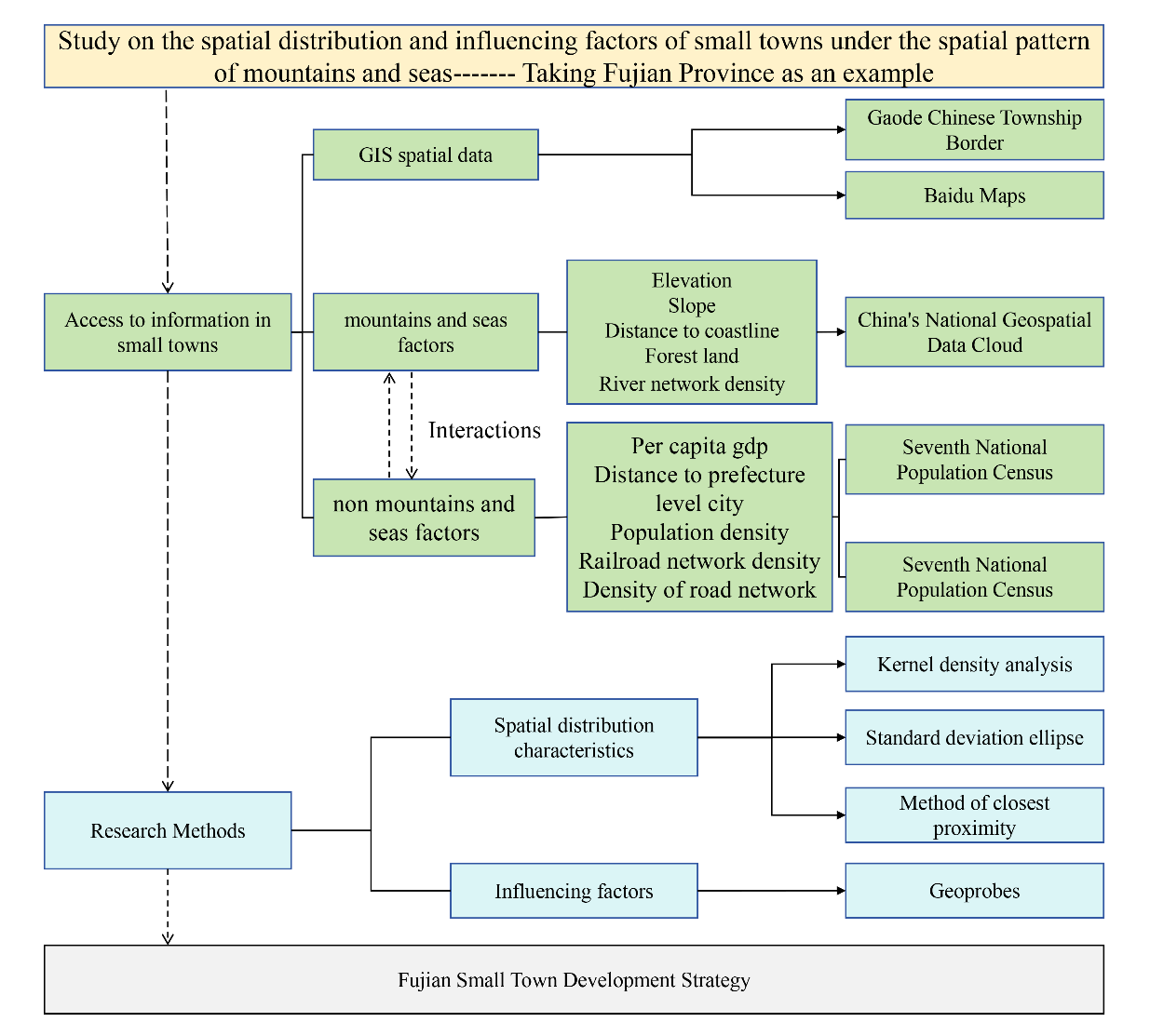
This paper conducts the following research taking Fujian Province in China as an example. Firstly, we collated the basic information of all small towns in Fujian Province. The point coordinates of small towns were picked up based on Baidu coordinates and then imported into GIS for visual analysis. Secondly, data on influencing factors related to small towns were collected, including mountain - sea factors such as elevation and slope, as well as non - mountain - sea factors like population and economy. These factors were used to assign values to the small towns in Fujian. Subsequently, kernel density, standard deviation ellipse, and the nearest - neighbor distance method were employed to reveal the spatial distribution characteristics of small towns in Fujian Province. The geographical detector method was utilized to explore the impacts of mountain - sea factors and non - mountain - sea factors on small towns in Fujian. Finally, through the analysis of the spatial distribution characteristics and influencing factors of small towns in Fujian, the main influencing factors affecting the distribution of small towns were determined, and some strategies were provided for the future development of small towns (Figure 1).
The kernel density analysis tool is mainly used to calculate the density of elements in their surrounding areas, and is divided into the kernel density analysis of point elements and line elements. Kernel density analysis of point elements is based on the principle of assigning the same weight to the points falling in the same area, summing them first, and then dividing them by the size of the area to get the density value of each point element, which is widely used in the analysis of spatial pattern of point elements (Jiang, Yang et al., 2019).
|
f
(
x
)
=
1
n
h
i
∑
i
=
1
n
k
(
x
−
x
i
h
) (1)
|
Where:
k
(
x
−
x
i
h
)
is the kernel function; h > 0 is the broadband; (
x
−
x
i
)
denotes the distance from the valuation point
x
to
x
i
.
f
(
x
)
The larger the value, the denser the point. In this study, we intend to use kernel density to discriminate the spatial distribution of small towns in Fujian, and to gain a deeper understanding of their spatial distribution characteristics.
Standard deviation ellipse
The standard deviation ellipse can reveal various features of economic spatial distribution, and is now widely used to characterize the spatial distribution and spatial and temporal evolution of various geographic "point elements". The area within the ellipse is the main area of the spatial distribution of the elements, the center of the ellipse is the center of all elements, the long axis of the ellipse indicates the main direction of the distribution of the elements, the flatness is used to describe the direction of the distribution of the elements, and the larger the value of which indicates that the direction of the distribution of the elements is more pronounced (Lu, Zhao et al., 2024) . In this study, it is proposed to use the standard deviation ellipse to discriminate the direction of the center of gravity of the spatial distribution of small towns in Fujian.
Average nearest neighbor analysis
The method of nearest neighbor distance is the distance from any point to its nearest neighbor, a geographic indicator that indicates the degree of proximity of point-like things to each other in geographic space (Wang, X., Qi et al., 2020). The specific calculation formula is as follows:
|
r
¯
E
=
1
2
n
A
=
1
2
λ
(2)
|
In Eq. (2):
r
¯
E
is the closest neighbor distance;
n
is the number of points; A is the area of the study area;
λ
is the density of points. In Eq. (3): R represents the nearest neighbor distance index;
r
¯
i
is the actual nearest neighbor distance. According to the closest point index, three distribution patterns can be judged: when R>1, the actual closest distance between points is greater than the theoretical closest distance, indicating that the points are mutually exclusive, tending to spatial uniform distribution; when R=1, indicating that the distribution of points from a completely random pattern, belonging to the spatial random distribution; when R<1, the actual closest distance between points is less than the theoretical closest distance, tending to spatial clustering distribution. This study intends to use the closest distance method to measure the closest point index of small towns at the provincial scale and municipal scale in Fujian Province, to analyze the spatial distribution pattern of small towns, and to macroscopically explore the spatial distribution pattern of small towns at different scales.
Geoprobes
Geoprobe is a statistical method for detecting spatial variability, as well as revealing the driving factors behind it and a mathematical model for spatially differentiated differences in geographic phenomena and for analyzing the interactions between independent and dependent variables (Wang, J. and Xu, 2017) . Currently, it has been applied to many fields such as urban development, social livelihood, and ecological protection. The formula is as follows:
|
q
=
1
−
∑
h
=
1
L
N
h
σ
n
2
N
σ
2
(4)
|
This study intends to use the geodetector method to measure the relationship between the dependent variable X and the independent data Y (influencing factors) of the spatial distribution density of small towns in Fujian, as well as the correlation effect relationship between the influencing factors, to further reveal the relationship between the spatial distribution characteristics of small towns and the influencing factors under the spatial pattern of mountains and seas.
Research Scope and Research Data
Research Scope
Fujian Province is located on the southeast coast of China, with a land area of 124,000 square kilometers and a sea area of 136,000 square kilometers. The eastern part of Fujian Province has a long and winding coastline, with mountainous and hilly terrain accounting for about 90% of the province's land area, and the terrain gradually decreasing from the mountains in the northwest to the coast in the southeast. The spatial pattern of Fujian Province is typically described as “eight mountains, one water, one field”, showing the unique spatial pattern of mountains and sea in the coastal area of southeastern China. There are four plains in the coastal area of Fujian, namely, Zhangzhou Plain, Fuzhou Plain, Xinghua Plain, and Quanzhou Plain, which are the result of the combined action of river alluviation and marine deposition, with the areas of 566 square kilometers, 489.1 square kilometers, 464 square kilometers, and 345 square kilometers, respectively, and the total area of the plains accounts for 10% of the total area of the province. As of 2020, the urban population of Fujian Province is 28,606,900 people, with an urbanization rate of 68.75%. This study selects Fujian Province in China as the study area, and takes all the established towns and established townships in Fujian Province as the study object (Figure 2), covering a total of 659 townships for in-depth exploration and analysis.

The list of small towns and population data in Fujian Province are derived from the official statistical results of the Seventh National Population Census of China. The township boundary information released by Gaode Map in 2019 for Fujian Province precisely matches the quantity and scope of the data from the Seventh National Population Census. Therefore, in this study, the township boundary information from Gaode Map in 2019 is adopted as the basic data for geospatial analysis. The longitude and latitude information of the government seats of small towns and prefecture - level cities is obtained from Baidu Map. The altitude and elevation data are calculated from the 12.5 - meter - resolution Digital Elevation Model (DEM) of China on the National Geospatial Data Cloud. The elevation data, with a resolution of 12.5m, are also used for slope calculation. In addition, the river network, road network, and railway data are all sourced from the national electronic map resources in 2019. The data related to social and economic development are obtained from the Fujian Statistical Yearbook and the statistical yearbooks of each county - level unit. The land - use data are derived from the Remote Sensing Monitoring Database of China's Land - use Status.
In terms of data processing, the present study carefully classified the research factors into two categories: mountain and sea factors and non-mountain and sea factors, based on the unique geographic feature of mountain and sea spatial pattern, and the selection strategy of the previous influencing factors (Wang, X., Qi et al., 2020; Zhang, Jiayu, Li et al., 2021). In view of the significant influence of mountain and sea factors on the development of small towns in Fujian Province, this study included the distance from the coastline, the proportion of forested land (Shen, Kong et al., 2024), as well as natural geographic factors such as slope (Liu, Y., Zhao et al., 2023), elevation (Wu, Yang et al., 2024), and the density of the river network in the mountain and sea factors. The non-mountain and sea factors cover socio-economic indicators such as GDP per capita, distance to neighbouring prefecture-level city centres, population density, railway network density, and road network density (Cao, Xu et al., 2024; Jin, Zhou et al., 2024; Tian, Guan et al., 2023; Wu, Yang et al., 2024). Based on the existing hierarchical classification criteria (Namaiti, Zeng et al., 2023), all independent variables were reclassified in this study (Table 1).
In terms of data calculation, the average slope and elevation values are statistically analyzed for each small - town unit using ArcGIS software, based on the 12.5 - meter - resolution Digital Elevation Model (DEM) data. Regarding the distance to the prefecture - level city center and the distance to the coastline, the straight - line distances from each small town to the nearest prefecture - level city and the coastline are calculated respectively using the point - distance analysis tool in ArcGIS. For the calculation of road network density, considering the different influencing degrees of roads at different levels on the development of small towns, this study refers to relevant research results (Tang, Li et al., 2022) and sets the following conversion formula, where 4, 3, 2, and 1 represent the conversion coefficients of expressways, national highways, provincial highways, and county highways respectively:
|
R
S
D
=
4
×
F
W
+
3
×
N
R
+
2
×
P
R
+
1
×
C
R
A
(5)
|
(5)
where: RSD is the road network density (km/km²), FW, NR, PR, and CR are the lengths (km) of expressways, national highways, provincial highways, and county highways within the small town respectively, and A is the area of the small - town unit.
Table 1. Values of influencing factors and their grades
| The Mountain and Sea Factor
|
Separate into different kinds
|
Assign a value to something
|
Non-mountain and sea factors
|
Separate into different kinds
|
Assign a value to something
|
| Elevation (m) |
<100 |
1 |
Per capita gdp (million yuan) |
<5 |
1 |
| [100,200] |
2 |
[5, 8] |
2 |
| [200,500] |
3 |
[8,10] |
3 |
| [5001000] |
4 |
[10, 15] |
4 |
| ≥1000 |
5 |
≥15 |
5 |
| Slope(degrees) |
<5 |
1 |
Distance to prefecture level city (km) |
<25 |
1 |
| [5, 10] |
2 |
[25,50] |
2 |
| [10,15] |
3 |
[50,75] |
3 |
| [15, 20] |
4 |
[75,100] |
4 |
| ≥20 |
5 |
≥100 |
5 |
| Distance to coastline (km) |
<20 |
1 |
Population density (persons/km²) |
<1 |
1 |
| [20,50] |
2 |
[1, 10] |
2 |
| [50,100] |
3 |
[10,50] |
3 |
| [100,200] |
4 |
[50,100] |
4 |
| ≥200 |
5 |
≥100 |
5 |
| Forest land (percentage) |
<20 |
1 |
Railroad network density (km/km²) |
<0.05 |
1 |
| [20, 40] |
2 |
[0.05,0.1) |
2 |
| [40,60] |
3 |
[0.1,0.5) |
3 |
| [60,80] |
4 |
[0.5,1] |
4 |
| ≥80 |
5 |
≥1 |
5 |
| River network density (km/km²) |
<0.05 |
1 |
Density of road network (km/km²) |
<0.05 |
1 |
| [0.05,0.1) |
2 |
[0.05,0.1) |
2 |
| [0.1,0.5) |
3 |
[0.1,0.5) |
3 |
| [0.5,1] |
4 |
[0.5,1] |
4 |
| ≥1 |
5 |
≥1 |
5 |
Characterization of Spatial Distribution of Small Towns in Fujian
Spatial agglomeration law of small towns
The global spatial analysis based on the ANN (Average Nearest Neighbor Analysis) method shows that the spatial distribution of small towns in Fujian Province exhibits significant multi-scale divergence characteristics, with an overall R value of 0.9396 (R < 1), indicating that the spatial distribution is a non-random agglomeration pattern. This result reveals the geospatial agglomeration trend of small towns in Fujian Province, reflecting the profound influence of the mountain and sea pattern on this distributional feature. At the prefecture level scale, the distribution of small towns is significantly heterogeneous and can be categorized into the following three typical patterns (Table 2):
Ⅰ Agglomeration-type distribution (R < 1): center gravity drive and mountain-sea synergy effect
Located at the mouth of Minjiang River, Fuzhou City resides in the transition area between Vulture Peak Mountain Range and Daiyun Mountain Range and the East China Sea Coastal Zone, forming a land and sea gradient pattern of “back to the mountains and face to the sea”. The distribution of small towns in Fuzhou City shows a “core-edge” pattern, with an R-value of 0.8896, which is significantly smaller than 1, indicating that the spatial agglomeration characteristics are significant. This phenomenon can be attributed to the following aspects:
1.Geographic base effect: Fuzhou City is located in the Fuzhou Plain, as one of the four major alluvial plains in Fujian Province, with flat topography and high suitability for land development, which provides a physical basis for the compact layout of small towns. The region is at the junction of the mountains and the sea, enjoying the transportation and economic advantages of the coastal area and the resource security of the inland mountains, realizing the organic synergy of the mountain and sea resources.
2.Economic Polarization Mechanism: As the capital city of the province, Fuzhou City, relying on its coastal port advantages and inland mountain resources, has formed a significant economic polarization effect. Through the “core - edge” effect, the economic radiation of the central city attracts the surrounding small towns to approach it, forming a centralized layout with the central city as the core.
3.Mountain and sea synergistic effect: the small towns around Fuzhou not only rely on the port economy of the coastal area, but also benefit from the ecological and agricultural resources of the inland mountainous areas, which further strengthens the agglomeration characteristics of the small towns.
Ⅱ Discrete Distribution (R>1): Topographic Constraint Dominance and Sea-Land Transition Effect
The six cities of Longyan, Xiamen, Sanming, Quanzhou, Putian and Nanping all have R values greater than 1. The spatial pattern of small towns presents discrete distribution characteristics, and their spatial differentiation can be attributed to:
1.Mountain constraint effect: western Fujian and northern Fujian are blocked by the Wuyi Mountains and Daiyun Mountains, with less than 15% of the plain area and a high index of terrain segmentation. The rigid constraints of mountainous terrain limit the spatial expansion of small towns, resulting in a discrete distribution of towns.
2. Resource Carrying Threshold: The proportion of buildable land in such areas is low and the road network connectivity is poor, and small towns are often distributed along the fracture zones in a “plate-corridor” distribution. This discrete distribution pattern reflects the significant limitation of mountainous resource carrying capacity on the layout of small towns.
3. Land and sea transition effect: Xiamen City, as a coastal city, its small towns show the paradox of “high urbanization rate - strong discrete”. The reason for this is that Xiamen has a limited land area and is constrained by the red line of coastal zone development, so the spatial expansion of towns is rigidly limited. As a result, small towns rely on transportation nodes to expand in patchy jumps, forming a multicore discrete structure with a significantly lower spatial compactness than similar cities. This distribution characteristic reflects the unique spatial layout pattern of coastal towns under the constraint of mountains.
Ⅲ Random-type distribution (R≈1): mountain and sea resource complementarity and spatial equalization effect
The distribution of small towns in Zhangzhou and Ningde is characterized by stochasticity, with R-values of 1.0731 and 1.0084 respectively, which are close to 1. This stochastic distribution is actually the spatial equilibrium effect of “mountain-sea resource complementarity” and “local agglomeration-global dispersion”, which reveals the following three aspects of geographic distribution. This random distribution is actually the result of the spatial equilibrium between “mountain-sea resource complementarity” and “local agglomeration-global dispersion”, which reveals the following three aspects of the offsetting effect of the geographic dichotomy:
1.Coastal agglomeration subunit: Zhangzhou City has formed a high density of towns and cities along the coastal strip, relying on the Zhangzhou Plain and the Sandouao harbor. This agglomeration phenomenon is closely related to the flat topography of the coastal strip and the radiation effect of the port economy.
2. Inland discrete subunit: Inland areas of Ningde City are mostly mountainous terrain with low suitability for agricultural production, resulting in significant differences in the density gradient of small town distribution. The constraints of mountainous terrain make the distribution of small towns show discrete characteristics.
3.Mountain-sea resource complementarity: coastal towns penetrate inland through the transportation arteries and convey the economic radiation power of the port, which partially offset the constraint effect of the mountainous terrain. This mountain-sea resource complementarity makes the distribution of small towns show local equilibrium characteristics.
Table 2. Analysis of the average nearest distances among small towns in Fujian
| Prefecture - level City
|
r-value
|
n
|
z scores
|
p values
|
Distribution Type
|
| Longyan City |
1.1365 |
89 |
2.4637 |
0.0138 |
Discrete |
| Fuzhou City |
0.8896 |
102 |
-2.1323 |
0.033 |
Clustered |
| Xiamen City |
1.3812 |
12 |
2.526 |
0.0115 |
Discrete |
| Sanming City |
1.1126 |
77 |
1.8896 |
0.0588 |
Discrete |
| Zhangzhou City |
1.0731 |
88 |
1.3115 |
0.1897 |
Random |
| Quanzhou City |
1.1009 |
110 |
2.0221 |
0.0431 |
Discrete |
| Putian City |
1.2471 |
40 |
2.9893 |
0.0028 |
Discrete |
| Ningde City |
1.0084 |
69 |
0.1330 |
0.8941 |
Random |
| Nanping City |
1.1089 |
72 |
1.7672 |
0.0772 |
Discrete |
| Entire Region |
0.9396 |
659 |
-2.9670 |
0.0030 |
Clustered |
Distribution pattern along the river to the sea
The spatial statistical analysis based on Standard Deviational Ellipse (SDE) shows that the distribution of small towns in Fujian Province as a whole is “Northeast-Southwest”, and the geometric center of gravity is shifted to the southwest relative to the administrative center of gravity, which forms a significant “Coastal-Inland” distribution pattern. The geometric center of gravity has shifted to the southwest relative to the administrative center of gravity, forming a significant difference in the gradient of “coastal-inland” (Figure 3). This spatial pattern reveals the following two major shaping mechanisms:
1.Mountainous blocking effect: The western mountainous areas of Nanping, Sanming and Longyan are mostly hilly, with steep terrain, which rigidly constrains the expansion of towns and cities. In addition, the scarcity of transportation corridors further restricts the population carrying threshold, forming a “fracture zone” for town development.
2. Driven by seaward gravity: Relying on topographical advantages and port economic effects, coastal areas such as Ningde, Fuzhou and Quanzhou have driven the spatial coupling of GDP and the number of towns and cities, forming a synergistic mechanism of population agglomeration and town scale expansion. This seaward gravitational effect makes small towns show higher densities in coastal areas.
Spatial density and mountain-sea gradient synergy
The spatial density analysis based on Kernel Density Estimation (KDE) shows that the spatial density of small towns in Fujian Province shows a significant sea and land gradient, which is characterized by a spatial heterogeneity pattern of “sparse in the interior and dense along the coast”. This pattern can be divided into the following three types of areas (Figure 4):
1.High-density Extreme Core Zone: Located at the junction of mountain and sea, including Fuzhou City, Putian-Quanzhou City, and Zhangzhou City, it is the first topographic gradient zone extending inland from the coastline. This area has a dual transportation gateway nature, high potential for building land development, and a clustered distribution of small towns based on the sea-land economic interface effect.
2.Belt corridor area: Along the major river basins such as the Min River and the Jiulong River, small towns show significant linear distribution characteristics along the river, forming a watershed development corridor. The transportation and resource conditions of the watershed corridor provide important support for the development of small towns.
3.Inland areas: small towns are evenly distributed, without forming significant agglomerations, with relatively low spatial density. This phenomenon indicates that the administrative boundaries of inland areas have a weak influence on the distribution of small towns.
Analysis of Influencing Factors on The Spatial Distribution of Fujian Small Towns
Assignment and visualization of influencing factors
Based on the natural geographic characteristics of the mountain and sea space, this study divides the influencing factors into two categories: mountain and sea factors and non-mountain and sea factors. In terms of mountain and sea factors, the focus is on topographic and geomorphic features and marine influence factors, including forest cover (reflecting vegetation ecological conditions), elevation (characterising topographic relief), slope (indicating the degree of steepness and gentleness of the terrain), river network density (reflecting hydrological conditions), and distance to the coastline (reflecting the degree of marine influence) (Tian, Guan et al., 2023; Zhou, Hu et al., 2024). In terms of non-mountain and sea elements, the main consideration is humanistic socio-economic development indicators, including: per capita GDP (measuring the level of economic development), population density (reflecting the intensity of human activities), road network density and railway network density (characterising the accessibility of transportation), and the distance to prefectural-level cities (reflecting the regional centrality) (Huang and Bai, 2023). This classification system fully takes into account the natural-humanistic composite characteristics of the mountain and sea space, and provides a scientific indicator system support for the subsequent spatial analyses. By grading the various types of influencing factors of small towns, the different spatial element layers are overlaid and intersected using GIS software, and classified and displayed according to the values of element attributes (Figure 5).
The GIS-based multi-factor overlay analysis shows that the flat terrain and dense river network at the mountain-sea junction provide superior natural conditions for the development of small towns. The GDP per capita is significantly higher in the east coast than in the north, and the road and railway networks are distributed along the main transport routes, resulting in a higher density of small towns. The population is concentrated in the eastern coastal region, with a ‘#’ distribution in terms of distance from neighbouring prefecture-level cities.
Analysis of the results of geodetector
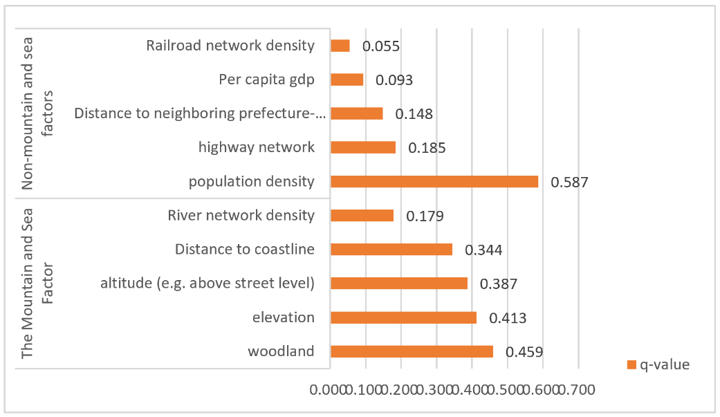
The results based on geodetectors and interactions showed that the drivers of small town distribution in Fujian Province all passed the significance test (p < 0.01), indicating that the distribution of small towns in Fujian Province has significant spatial heterogeneity, and at the same time, the results showed that the mountain and sea factors had a higher influence on the spatial distribution of small towns than the non-mountain and sea factors (Figure 6).
Population density (q=0.587) and forest land (q=0.459) dominated the spatial distribution of small towns in Fujian Province. Among the mountain and sea factors, except for the river network density (q=0.179), all other influencing factors showed significant influence (q>0.3); among the non-mountain and sea factors, except for the population density, other influencing factors had little influence, among which the railroad network had the lowest influence (q=0.055).
Based on the results of the analysis, areas with higher population density have flat topography, high transportation accessibility, excellent resource endowment and abundant human resources, and the topography-population composite driving force accelerates the development of small towns, while driving the development of the surrounding areas. Woodland and slope are also important factors affecting population concentration. In Fujian province, 90% of the area is hilly, and the low accessibility of the road network and the high degree of topographic relief limit the development of small towns. Therefore, population density, forest land and slope are important factors affecting the spatial distribution of small towns.
In addition, the proximity to the coastline also significantly affects the distribution of small towns. There are 295 small towns less than 50 kilometers from the coastline, while there are only 100 small towns more than 200 kilometers from the coastline, a difference of nearly three times. Coastal areas are richer in resources and are able to rely on the coastline for trade and other economic activities, thus promoting the clustering and development of small towns.
Analysis of the correlation of influencing factors
Through the correlation analysis of influencing factors, there are certain regularities in the interaction intensities among these factors. Population density exhibits a relatively strong interaction with other variables, followed by the distance to the coastline, slope, and elevation. Among them, the interaction between population density and elevation is the most significant, with a q - value reaching 0.644; while the interaction between railway network density and the distance to the nearest prefecture - level city is the weakest, with a q- value of 0.207 (Figure 7).
In terms of the types of interaction, except that the interactions between river network density and per capita GDP, as well as between railway network density and per capita GDP, show non - linear enhancement (the q- value of the interaction is greater than the sum of the two factors), the interactions of the remaining factors show two - factor enhancement (the q- value of the interaction is less than the sum of the two factors). Although the q - values of variables other than population density, slope, elevation, forest land, and the distance to the coastline are relatively small (q<0.3), their interactions with these factors show relatively high q - values. Especially, the q- values resulting from the interactions of population density with other factors are the highest, indicating that other factors can have a significant impact on the spatial distribution of small towns only when the levels of population density, elevation, slope, forest land, and the distance to the coastline are sufficient.

Impact of The Spatial Pattern of Mountains and Seas on The Distribution of Small Towns
The spatial layout and development process of small towns is a complex system of multiple factors, among which the spatial pattern of mountains and the sea, as the core geographical element, plays a crucial role in shaping the morphology and location of small towns. Specifically, the natural geographic conditions, such as slope, elevation and distance to the coastline, profoundly depict the basic framework of the spatial distribution of small towns. Areas with gentle topography and suitable for construction are often the ideal places for small towns to prioritize their expansion, while the distance to the coastline affects the resource endowment, economic vitality and population concentration of small towns in multiple dimensions. In particular, coastal areas have become strategic highlands for small towns to flourish due to their unique transportation advantages and resource richness (Figure 8). To summarize the specific actions of Fujian Province's mountain and sea spatial pattern on the morphology and location choice of small towns, it can be specifically summarized in the following three aspects:
1.Natural geographic conditions: slope, elevation and coastline distance constitute the basic framework for the distribution of small towns. The rigid constraints of mountainous terrain on the expansion of towns and the seaward gravitational pull of coastal areas jointly shape the spatial distribution pattern of small towns.
2.Mountain-sea junction zone: the area within 50 kilometers from the coastline has become a priority gathering area for small towns because of its flat topography and abundant resources. This zone not only relies on the transportation and economic advantages of coastal ports, but also benefits from the resource support of inland mountains, forming a “mountain-sea synergy effect”.
3.Classification of town forms: Based on topographical and geomorphological features, small towns can be divided into four categories: plains-type, mountain-type, valley-type and mountain-sea-type. Among them, mountain and sea-type small towns have higher economic development potential and spatial expansion capacity due to the dual resource advantages of coastal and mountainous areas.
Analysis of the 2010 to 2020 census data in Fujian Province shows that the size of coastal small towns continues to expand, while inland areas face the challenge of downsizing, reflecting the long-term trend of population agglomeration towards the coast (Table 3). This trend further confirms the far-reaching impact of the mountain and sea pattern on the distribution and development of small towns.
Table 3. Changes in the size of small towns in Fujian Province
| Typology
|
2010 volume (units)
|
Number in 2020
|
Change in number (units)
|
Population size (10,000)
|
| Small mega-towns |
147 |
160 |
13 |
≥5 |
| Large small towns |
223 |
196 |
-27 |
2-5 |
| Small medium-sized towns |
192 |
173 |
-19 |
1-2 |
| Small and medium-sized towns |
88 |
101 |
13 |
0.5-1.0 |
| Small towns |
9 |
29 |
20 |
<0.5 |
Conclusion
In this paper, the spatial distribution characteristics of 659 small towns in Fujian Province are discussed in depth using spatial analysis methods such as mean nearest neighbour analysis, kernel density estimation and standard ellipse difference. Subsequently, with the help of geodetector models, the dominant factors affecting the spatial distribution of small towns in Fujian were identified in terms of population size, topographic elevation, road network density, and distance to the coastline, and the interaction mechanisms among these factors were further analysed.
At the level of mountain and sea spatial pattern, the distribution of small towns gradually tends to be in the mountain and sea junction zone, and the number of small towns in the inland area of Fujian is significantly lower than that in the coastal area. In terms of spatial distribution pattern, Fujian small towns show a significant distribution of agglomeration, and the overall spatial direction is ‘Northeast-Southwest’, which is a big deviation from the contour of the administrative area of Fujian Province. In terms of spatial distribution, the characteristic of ‘sparse in the interior and dense along the coast’ is obvious, and three major contiguous areas and several belt-shaped distribution areas have been formed locally. The inland area of Fujian is dominated by belt-shaped and uniform distribution, while the contiguous area is mainly concentrated in the coastal area. Small towns are mainly distributed along the coastline and major rivers, which is significantly different from the distribution pattern of most coastal cities centred on administrative districts. The geographic characteristics of Fujian, which is more mountainous and less plain, make the distribution of small towns more dependent on the sea and rivers rather than the centre of administrative divisions, a feature that needs to be taken into account in the spatial layout and optimisation of small towns in the future. In the analysis of influencing factors, population density (q=0.587), slope (q=0.413), and forest area (q=0.459) are identified as the dominant individual factors affecting the spatial distribution of small towns in Fujian, and these factors should be given due attention in the future spatial layout planning of small towns. The interactions between variables were mainly shown as nonlinear enhancement and two-factor enhancement, indicating that the influence effect of a single factor is often enhanced in the interaction with other factors.
Based on the results of analysing the spatial distribution characteristics of small towns in Fujian Province and their influencing factors, the following ideas are proposed for the development of small towns in Fujian Province. Firstly, priority should be given to the development of mountain and sea junction areas. In view of the tendency of small towns to cluster in the mountain-sea junction area, the government should give priority to infrastructure construction and public service support in this area, so as to promote the effective integration of mountain-sea resources. Through the establishment of a ‘mountain and sea economic belt’, the government can promote the linkage between coastal and inland development and form a regional economic growth pole. Second, optimise the spatial layout of the coast and the interior. In view of the status quo of dense small towns in coastal areas and sparse inland areas, the government should encourage the development of inland small towns through policy guidance. It can enhance the attractiveness of inland small towns and alleviate the pressure of population and resources in the coastal area through the optimisation of the transportation network and the transfer of industries. Third, plan the development of small towns according to local conditions. In areas with complex mountain and sea terrain, the development of special industries should be combined with population density and resource conditions to avoid overdevelopment. In densely populated areas, public service facilities should be strengthened to enhance the carrying capacity of small towns. Fourth, promote regional economic integration. Strengthen the transport network and industrial chain extension between small towns and central cities to form regional economic growth poles. The density of road network is an important factor affecting the distribution of small towns, and the construction of transport network should be strengthened in the future to promote the connectivity between small towns. In addition, the distribution of small towns deviates from the centre of administrative divisions, and the linkage development between small towns and regional central cities should be strengthened. The synergistic development of small towns and central cities can be promoted through the optimisation of the transportation network and the extension of the industrial chain to form regional economic integration.
The spatial distribution of small towns in Fujian Province is the result of the long-term joint action of mountain and sea patterns, and its study not only provides an important reference for the development of small towns in coastal provinces, but also provides a scientific basis for the optimisation and planning of future spatial layout.
Author Contributions
Conceptualization, X.C., L.S.S. and J.Q.Y.; methodology, P.F.Y. and L.S.S.; software, J.Q.Y.; validation, X.C. and L.S.S.; formal analysis, X.C.; investigation, J.Q.Y.; resources, Y.Y.F. and P.F.Y.; writing—original draft preparation, X.C. and L.S.S.; writing—review and editing, X.C., J.Q.Y., Y.Y.F. and P.F.Y.; visualization, P.F.Y. and X.C. ; supervision, S.L.S. and Y.Y.F.; All authors have read and agreed to the published version of the manuscript.
Ethics Declaration
The authors declare that they have no conflicts of interest regarding the publication of the paper.
Funding Statement
This paper was supported by the Research Project of Humanities and Social Sciences of the Ministry of Education (24YJA630010), the Research Project of Humanities and Social Sciences of the Ministry of Education (23YJA630117), and the 2024 Open Fund Project of Fujian Provincial Key Laboratory of Ecological Monitoring and Protection and Utilization of Island Resources (2024ZD05). We sincerely thank them for their support.
References
- Basirat, M. and Arbab, P. (2022). "Analysing New Town Development in Iran: Toward a New Agenda". International Review for Spatial Planning and Sustainable Development, 10(3), 84-107. doi: https://doi.org/10.14246/irspsd.10.3_84.
- Cao, C., Xu, L., et al. (2024). " Characteristics of Regional Spatial Patterns of Rural Settlements in Xinjiang and Analysis of Influencing Factors". Regional Research and Development, 43(5), 109-116. doi: https://doi.org/10.3969/j.issn.1003-2363.2024.05.017.
- Chen, Y., Li, W., et al. (2006). "Study on the Development of Spatial Structure of Small Towns with Mountain and Water--Taking Shaoxing Xiaoyue Town as an Example". Journal of Zhejiang University of Technology, (2), 224-227.
- Cheng, J., Zhang, Q., et al. (2024). "Research on the Distribution and Conservation of Song-Yuan Kiln Sites in Fujian from the Perspective of Heritage Corridor". International Review for Spatial Planning and Sustainable Development, 12(1), 59-80. doi: https://doi.org/10.14246/irspsd.12.1_59.
- Cheng, R., Chen, W., et al. (2019). "Spatiotemporal Variation Characteristics of Ecosystems and Their Driving Forces in the Min Delta Urban Agglomeration". International Review for Spatial Planning and Sustainable Development, 7(1), 177-194. doi: https://doi.org/10.14246/irspsda.7.1_177.
- Huang, X. and Bai, O. (2023). " Spatial Distribution Characteristics and Influencing Factors of Fine Villages in Zhejiang Province". Modern Urban Research, (7), 57-64.
- Jiang, J., Yang, Q., et al. (2019). "Spatial Pattern of Intangible Cultural Heritage and Tourism Development Mode in Chongqing". Economic Geography, 39(6), 205-213.
- Jin, D., Zhou, J., et al. (2024). "Research on the Spatial Pattern and Influencing Factors of Mobile Population in Beijing-Tianjin-Hebei City Cluster". Urban Development Research, 31(12), 34-44.
- Liu, L. and Ren, Y. (2018). "Study on the Spatial Distribution Characteristics of Small Towns in Gully Areas of the Loess Plateau in Longdong". Huazhong architecture, 36(3), 66-70.
- Liu, Y., Zhao, Q., et al. (2023). "Analysis of Spatial Distribution Pattern and Influencing Factors of Rural Villages in Liaoning Province". Remote Sensing Information, 38(5), 81-88. doi: http://dx.chinadoi.cn/10.20091/j.cnki.1000-3177.2023.05.011.
- Lu, Y., Zhao, S., et al. (2024). "Study on the Spatial and Temporal Evolution Characteristics of Ethiopian Urban System and Its Influencing Factors". International Urban Planning, 3, 1-16.
- Ma, F. and Li, M. (2022). "Spatial-Temporal Characteristics of Urban Expansion in Shenyang from 2001 to 2014". International Review for Spatial Planning and Sustainable Development, 10(4), 161-173. doi: https://doi.org/10.14246/irspsd.10.4_161.
- Namaiti, A., Zeng, S., et al. (2023). "Spatial Distribution Characteristics and Influencing Factors of Small Towns in Xinjiang". Small Town Construction, 41(7), 85-92. doi: https://dx.doi.org/10.3969/j.issn.1009-1483.2023.07.012.
- Nieto Masot, A., Cardenas Alonso, G., et al. (2020). "Spatial Analysis of the Rural-Urban Structure of the Spanish Municipalities". ISPRS International Journal of Geo-Information, 9(4), 213. doi: https://doi.org/10.3390/ijgi9040213.
- Shen, H., Kong, X., et al. (2024). " Characteristics of Spatial Distribution of Forested Villages in the Yangtze River Delta Region and Analysis of Their Influencing Factors". Yangtze River Basin Resources and Environment, 33(4), 773-783.
- Tang, Y., Li, X., et al. (2022). "Spatial and Temporal Evolution of Small Towns in China under the Background of Rapid Urbanisation and the Influencing Factors". Economic Geography, 42(3), 66-75. doi: https://www.jjdl.com.cn/EN/10.15957/j.cnki.jjdl.2022.03.007.
- Tian, C., Guan, X., et al. (2023). "Spatial Distribution Characteristics of Key Villages for Rural Tourism in the Yellow River Basin and Their Influencing Factors". Journal of Tourism, 38(8), 32-44.
- Wang, J. and Xu, C. (2017). "Geodetector:Principles and Prospects". Journal of Geography, 72(1), 116-134.
- Wang, X., Qi, W., et al. (2020). " Characteristics of Spatial Distribution of Small Towns in China and Their Related Factors". Geography Research, 39(2), 319-336.
- Wang, Y., Sun, B., et al. (2021). "Spatial and Temporal Evolution Characteristics and Influencing Factors of National City Size Distribution - a Global Empirical Study Based on Landscan". Progress in Geographical Sciences, 40(11), 1812-1823.
- Wen, C., Wang, L., et al. (2021). "Research on Land and Sea Integration in Spatial Planning of Small Towns in Coastal Zones". Urban Planning, 45(9), 46-52,102.
- Wu, S., Yang, G., et al. (2024). "Research on Spatial Distribution Characteristics and Influencing Factors of Rural Tourism in Sichuan Province". Regional Research and Development, 43(5), 88-93,102. doi: https://doi.org/10.3969/j.issn.1003-2363.2024.05.014.
- Zhang, J., Chen, S., et al. (2018). " Evolution and Spatial Distribution Characteristics of Urban Systems in Tanzania". World Geography Research, 27(1), 22-33.
- Zhang, J., Li, J., et al. (2021). " Spatial Distribution Characteristics of Small Towns in Ningxia and Analysis of Their Influencing Factors". Arid Zone Resources and Environment, 35(7), 56-63.
- Zhang, Z., Tang, X., et al. (2022). "Built-Environment Determinants of Active Travel Behavior of Older Adults in Xiamen, China". International Review for Spatial Planning and Sustainable Development, 10(4), 130-145. doi: https://doi.org/10.14246/irspsd.10.4_130.
- Zhou, W., Hu, C., et al. (2024). "Study on the Spatial Distribution and Influencing Factors of Rural Lodging Tourism in the Shaanxi Section of the Qinling Mountains". China Agricultural Resources and Zoning, 45(4), 235-246.