Literature Review
The role, function, and challenges of spatial planning in ensuring the security and safety of aviation
The spatial planning document ensures aviation operations' safety and security within an Airport Public Safety Zone (PSZ). These documents typically govern land use and control, including zoning regulations and strict restrictions to protect aviation operations and the surrounding public. In many countries, including Indonesia, spatial plans are developed by local governments in collaboration with various stakeholders and serve as legal guidance for those engaged in development activities within the airport PSZ area.
The content of spatial planning guidance focuses on three main components essential for ensuring the safety and security of aviation operations in an Airport Public Safety Zone: land use compatibility, building height and material, and the management of landscaping and growing objects (Ashford, Mumayiz et al., 2011; de Barros, 2013). The Land Use Plan, a core part of the spatial planning document, provides directions for land use that align with aviation operations' safety and security interests within the PSZ area. Typically, inappropriate activities such as those attracting large crowds or high-density and noise-sensitive land use (e.g., residential areas, hospitals, schools) are prohibited (Ashford, Mumayiz et al., 2011; Australian Government - Department of Infrastructure, 2018; Contreras-Alonso, Ezquerra-Canalejo et al., 2020; de Barros, 2013; Freestone and Baker, 2011; Horonjeff and McKelvey, 1993; Mascio, Perta et al., 2018; Neufville and Odoni, 2013).
Spatial planning documents often contain guidance on land management through zoning regulations. In the context of PSZs, this includes restrictions on building height and physical structures like towers and limits on using hazardous materials. The height of buildings and structures categorized as obstacles is strictly controlled to avoid obstructing flight paths or interfering with navigation aids. Activities involving flammable materials, explosives, and toxic substances, such as gas stations, chemical plants, and fuel tanks within the PSZ area, are tightly regulated (Ashford, Mumayiz et al., 2011; Contreras-Alonso, Ezquerra-Canalejo et al., 2020).
Managing landscaping and growing objects within the PSZ area is essential to spatial planning. The document generally prohibits specific vegetation or facilities that may attract wildlife activities. Clusters of trees and facilities like landfills, bodies of water, agricultural activities, and waste management facilities within the PSZ are strictly regulated to avoid attracting wildlife, particularly birds and mammals. Their presence can increase the risk of wildlife strikes, which can cause damage to aircraft, disrupt operations, and pose safety risks to passengers and crew during take-off and landing.
Despite the vital role and function of spatial planning documents in ensuring the safety and security of aviation operations within the PSZ area, drafting these documents can take time due to various complex issues. The first significant challenge is balancing competing interests within the PSZ area (de Barros, 2013). Spatial plans must balance aviation safety requirements with the economic and developmental interests of local communities living within the PSZ. This can lead to conflicts between the desire for urban growth and the need to restrict specific land uses near airports.
Recently, airport-led development concepts such as Aerotropolis and Aero city have increased local governments' desire to intensify physical development around the airport area (Freestone, 2009). They view the airport and its surroundings as economic and business hubs that must be leveraged to enhance economic competitiveness. This pressure is exacerbated by rapid urban sprawl, which places increasing pressure on the airport and its PSZ area due to urban development (de Barros, 2013). These conditions may lead spatial plan drafters to adopt a more compromising stance on aviation safety and security interests.
Balancing interests becomes even more complex in PSZ areas of military airports due to potential conflicts in balancing economic and urban development against military aviation operations for national defense and airspace security. The nature of military authorities, which tend to be secretive and may withhold critical data such as aircraft types, maneuverability, airport expansion plans, and noise levels, can make developing an effective spatial plan challenging.
Additionally, stronger mainstreaming of aviation safety and security within airport PSZs may arise from low stakeholder engagement (de Barros, 2013). Poor communication and coordination, especially with airport authorities, can lead to a lack of alignment between spatial planning directives and aviation safety standards. Excluding experts or failing to integrate various safety and security standards and regulations can exacerbate this issue. For example, some countries still need standards for ideal land use in PSZ areas, so they must carefully identify and find internationally accepted regulations (Wong, Pitfield et al., 2009).
Difficulties in enforcing safety and security standards in PSZ areas also arise when areas around airports are already invaded by activities incompatible with aviation operations' safety and security interests. This is often due to weak oversight, control, and enforcement of regulations. Property owners may resist when spatial planning documents instruct them to change their land use, activities, or building heights, as this can lower property values, impact existing businesses, and alter their daily lives. A study suggests that using Cost-Benefit Analysis (CBA) can help identify which land uses need to be modified to align with aviation safety and security standards. However, implementing CBA may prove difficult due to the potential pressure and conflicts arising from stakeholders who feel disadvantaged by the changes. This scenario can weaken restrictions within airport PSZ areas (Distefano, Leonardi et al., 2007).
Safeguarding PSZ: The significance of RDTR and PZ document in Indonesia
Detailed Spatial Plans and Zoning Regulations, referred to as Rencana Detail Tata Ruang dan Peraturan Zonasi (RDTR & PZ) in Indonesia, play a crucial role in ensuring the safety of aviation zones, making them indispensable components within the realm of comprehensive land use management within specific areas. These meticulously crafted plans serve as detailed extensions of broader Regency/City Spatial Plans, effectively governing land use plans and control. The local governments in Indonesia heavily rely on RDTR and PZ documents as primary references for granting permits for spatial activities, including land use and building permissions, in accordance with prevailing regulations (Pramono, Palupi et al., 2022). This also known as Conformity of Spatial Utilization Activities (Kesesuaian Kegiatan Pemanfaatan Ruang) (Setiabudhi, Palilingan et al., 2023). These documents encompass a diverse range of elements, including spatial planning objectives, spatial structure plans, land use plans, and zoning regulations, forming a coherent and comprehensive framework that guides land development, investment location determination, and spatial utilization activities, thereby fostering sustainable and organized development within specific regions.
Zoning is a regulatory framework that organizes land use into designated categories to ensure compatibility, prevent conflicts, and promote sustainable urban development. It establishes spatial parameters such as lot size, building mass, height limitations, and floor area ratios (FAR) to maintain a balanced and efficient urban environment (Sharma, Saini et al., 2023; Tutuko, Bonifacius et al., 2022). In the context of Rencana Detail Tata Ruang (RDTR), zoning regulations play a crucial role in guiding land utilization by defining permissible activities, regulating building intensity (e.g., Building Base Coefficient, Building Floor Coefficient, Minimum Green Base Coefficient), and setting layout specifications (e.g., Maximum Building Height, Building Delimitation Lines) and infrastructure requirements for different zones or sub-zones (Putung and Perdana, 2019) . Functioning as operational tools for controlling spatial usage, they offer valuable recommendations for appropriate land utilization activities, incorporating incentives and disincentives and enabling sanctions when necessary. Furthermore, specific provisions elaborate on the Aviation Safety Operation Area regulations within the zoning regulations applicable in Indonesia. This is due to particular circumstances that necessitate their unique regulations, which are not covered by the foundational rules (Putung and Perdana, 2019). Clear and well-structured zoning regulations must be addressed, especially in establishing and maintaining aviation safety zones.
In the broader context, RDTR & PZ hold a central role in comprehensive land use management, particularly in ensuring the safety and security of aviation operational zones. By offering thoughtful guidance in land development and imposing suitable constraints, these regulations significantly contribute to aviation safety and the well-being of communities near airports. Their meticulous application ensures a harmonious balance between urban development and aviation operations, fostering a secure and sustainable environment for all stakeholders. This highlights the rationale behind Article 211 of Law 1 of 2009 concerning aviation, which mandates all local governments to formulate detailed spatial plans, thus providing a controlled development framework around airports without compromising aviation safety and security, despite variations in implementation across different areas (Winaya and Wardhani, 2016).
Public Safety Zones in aviation: Risk mitigation and development restrictions
Public Safety Zones (PSZ) are critical components in aviation safety, strategically positioned at the ends of runways or runway strips. Their primary purpose is to restrict development within specific boundaries, thereby minimizing obstacles and ensuring the safety of the public in the event of potential aircraft accidents during take-off or landing (Ashford, Mumayiz et al., 2011; Davies and Quinn, 2004; Distefano, Leonardi et al., 2007; Pavlin and Bračić, 2011). Each Public Safety Zone encompasses an expansive area of 4 km², equivalent to 36 million square feet, extending laterally up to 0.5 km (1640 feet) from the centerline of each runway in both directions. Longitudinally, it stretches for a distance of 4.0 km (13,120 feet) from the end of each paved runway surface (Ashford, Mumayiz et al., 2011).
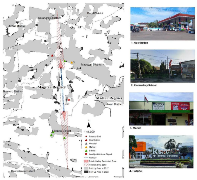
In Indonesia, the PSZ is encapsulated within the broader framework of the Flight Operation Safety Area, commonly referred to as KKOP. It is not explicitly designated as the PSZ but as the "Area of Potential Accident Hazard." This area spans 0 to 3,000 meters from the runway's end and intersects with the Inner Horizontal Surface. A visual representation of the airport PSZ within the KKOP scheme is provided in Figure 2.
Aircraft accidents during take-off or landing events pose substantial risks to the environment, public health, and safety, primarily due to the uncontrolled release of hazardous materials. Therefore, the stringent regulation and limitation of development within these designated PSZs are paramount (Ashford, Mumayiz et al., 2011; Davies and Quinn, 2004). Areas characterized by high population density or those frequently attracting large crowds, such as shopping malls, industrial zones, stadiums, and sports facilities, are particularly vulnerable and merit specific designations as public safety zones (Ashford, Mumayiz et al., 2011; Australian Government - Department of Infrastructure, 2018; Mascio, Perta et al., 2018). Conversely, activities that have the potential to interfere with navigation signals, disrupt radio communications, obstruct airfield lighting, create glare, reduce visibility, pose a bird hazard, or involve the use of weapons or fireworks with projectiles traveling over 45 meters within a distance of approximately 4 kilometers should be strictly (International Civil Aviation Organization, 2009; The Regulation of the Minister of Transportation of the Republic of Indonesia Number KM 44 of 2005, 2005). On the other hand, activities that can be permitted include long-term parking, employee car parking, and the installation of machinery/plants without regular on-site personnel, such as electricity switching stations or water supply facilities (Australian Government - Department of Infrastructure, 2018; The Regulation of the Minister of Transportation of the Republic of Indonesia Number KM 44 of 2005, 2005).

Land use within the airport PSZ area must also be rigorously regulated across various radii calculated from the airport runway end. Within a range of 0 to 600 meters from the runway, new occupancy is prohibited, with limited industrial activity permitted, subject to restrictions on the number of workers and working hours (Australian Government - Department of Infrastructure, 2018; California Department of Transportation, 2011; International Civil Aviation Organization, 2009; Mascio, Perta et al., 2018). Between 600 and 1,500 meters from the runway, buildings with low density and limited industrial activity are permissible (International Civil Aviation Organization, 2009; Mascio, Perta et al., 2018). However, within a 1000-meter radius, high-density buildings, shopping centers, meeting halls, sports facilities, densely populated housing, storage of flammable/explosive/hazardous materials, and significant transportation infrastructure that may attract large crowds are strongly discouraged (Ashford, Mumayiz et al., 2011; Australian Government - Department of Infrastructure, 2018; International Civil Aviation Organization, 2009; Mascio, Perta et al., 2018; The Regulation of the Minister of Transportation of the Republic of Indonesia Number KM 44 of 2005, 2005). Finally, within a distance of 1,500 to 3,000 meters from the runway end, mixed residential buildings with medium density and industrial activity are allowed (California Department of Transportation, 2011; International Civil Aviation Organization, 2009; Mascio, Perta et al., 2018).
In addition to regulating land use, stringent regulations govern building heights within the PSZ area. This ensures the absence of obstacles that could jeopardize aircraft safety, prevents tall buildings from obstructing flight paths, reduces accident risks and bird collisions, facilitates emergency procedures, mitigates noise disturbances, enhances security, and aligns with national and international standards. These regulations also contribute to maintaining the quality of life for nearby residents. Technically, buildings within a 4,000-meter radius from the runway must not exceed a height of (45 + H) meters above the lowest runway threshold elevation (The Regulation of the Minister of Transportation of the Republic of Indonesia Number KM 44 of 2005, 2005). Moreover, there are prohibitions within a 300-meter radius from the runway end for the use of metal structures and electrical poles and within a 600-meter radius for High Voltage Power Lines (HVPL) (California Department of Transportation, 2011; Mitsevich and Zhukovskaya, 2021; The Regulation of the Minister of Transportation of the Republic of Indonesia Number KM 44 of 2005, 2005). Lastly, within a 1000-meter radius from the runway end, no clusters of trees or tall objects exceeding 40 meters in height are permitted (Mitsevich and Zhukovskaya, 2021; The Regulation of the Minister of Transportation of the Republic of Indonesia Number KM 44 of 2005, 2005).
The growth and positioning of objects or structures within the PSZ area are subject to strict regulation and control to ensure unobstructed flight paths, except trees allowed within the initial third of the approach direction (International Civil Aviation Organization, 2009; Pavlin and Bračić, 2011; The Regulation of the Minister of Transportation of the Republic of Indonesia Number KM 44 of 2005, 2005). Within a 1000-meter radius from the runway end, the control and prohibition of clusters of trees exceeding 40 meters in height are imperative. Tall trees pose obstacles during take-off and landing, leading to accidents and damage. Additionally, they can attract birds, increasing the risk of bird strikes, disrupting instrument approaches, limiting emergency procedures, and affecting noise abatement efforts.
Result and Discussion
Identifying and classifying components and rules within the airport PSZ to ensure aviation operations’ safety and security and determine codes
The literature review has identified key components and regulations pertinent to ensuring the safety and security of aviation operations within airport PSZ. Following the principles of the DCA, these components and regulations were systematically categorized based on shared characteristics and intended regulatory guidance. This classification process resulted in three main components: (1) Airport Runway Land Use Restrictions, (2) Height Restrictions near Airports, and (3) Clearances and Tree Restrictions. Each component encompasses various regulations, codified as research variables for subsequent analysis (see Table 1).
Table 1. Components, rules, and variable codes
| No
|
Component
|
Rule
|
Variable code
|
| 1. |
Airport Runway Land Use Restrictions (ARLUR) |
0-600 meters from the runway end: No new residential buildings, limited industrial activities allowed. |
ARLUR 1 |
| 600-1500 meters from the runway end: Low-density buildings, limited industrial activities permitted. |
ARLUR 2 |
| 1500-3000 meters from the runway end: Mix of medium-density residential and new industrial activities allowed. |
ARLUR 3 |
| Within 1000 meters from the runway axis: Avoid high-density buildings, shopping malls, congress and sports centers, intensive housing, flammable/explosive/noxious materials, crowded transport infrastructure, and land uses attracting large crowds. |
ARLUR 4 |
| Suitable for long-stay parking, employee car parking, and machinery/plants without regular on-site personnel (e.g., electricity switching stations or water supply installations). |
ARLUR 5 |
| Maintain low-density land uses along military runways' flight paths to minimize public safety risks. |
ARLUR 6 |
| Prohibited activities: Interference with navigation signals, obstructing airfield lighting, impeding radio communications, causing glare, reducing visibility, creating bird hazards, and using weapons/fireworks with projectiles exceeding 45 meters within 4 kilometers. |
ARLUR 7 |
| 2. |
Height Restrictions near Airports (HRA) |
Within 300 meters from the runway end: Prohibit metal structures and electrical poles. |
HRA 1 |
| Within 600 meters from the runway end: Prohibit High Voltage Power Lines (HVPL). |
HRA 2 |
| Within 1000 meters from the runway end: Prohibit clusters of trees and buildings exceeding 40 meters in height. |
HRA 3 |
| Along a distance of 4000 meters from the runway centerline extension: Limit building and growing objects’ height to (45 + H) meters above the lowest runway threshold elevation. |
HRA 4 |
| 3. |
Clearances and Tree Restrictions (CTR) |
Public Safety Zone (0 – 4.000 meters): Clear of structures or obstacles, except for trees allowed in the first third of the approach direction. |
CTR 1 |
| Within 1000 meters radius: Prohibited clusters of trees exceeding 40 meters in height. |
CTR 2 |
The first component addresses regulations governing land use and development near airport runways. These regulations aim to safeguard flight operations, mitigate risks to the public, and manage potential hazards associated with land activities near airports. Their overarching goal is to balance urban expansion and aviation safety, preventing incompatible land uses that could endanger aircraft operations and ground personnel. While allowing for appropriate development within specified distances from runways, these regulations ensure a secure separation between high-risk activities and airport operations.
The second component delineates regulations concerning the allowable height of structures and objects near airports. These regulations primarily seek to enhance aviation safety and prevent obstructions to aircraft. They aim to ensure that structures, such as buildings and other objects, do not impede aircraft during take-off, landing, or flight within the airport's airspace. Specific requirements vary based on proximity to the runway, with stricter height restrictions closer to the runway to facilitate unobstructed aircraft movement.
The subsequent set of regulations, termed Clearances and Tree Rules (CTR), pertains to the minimum clearance required around trees and buildings. These regulations are established to uphold aviation safety standards and ensure unobstructed flight paths for aircraft. The primary objective is to develop secure zones for aircraft, preventing obstructions during critical flight phases, particularly during landing maneuvers. The stringency of these regulations increases with proximity to the runway, ensuring that the airspace surrounding the airport remains clear and safe, facilitating uninterrupted and secure flight operations for all aircraft and passengers.
Identifying textual evidence in the RDTR and PZ document
The content or textual evidence about the safety and security of the military airport PSZ at Iswahjudi has been identified in several chapters within the RDTR and PZ document for the Maospati Area. These chapters are as follows: Chapter 3 addresses Spatial Arrangement Objectives; Chapter 4 focuses on Spatial Pattern Plans; Chapter 7 provides detailed Space Utilization Regulations; and Chapter 8 concerns Zoning Regulation. A comprehensive overview of the content or evidence text within each chapter, along with detailed information regarding its location within the document, is provided in the table available in the Appendix.
Interpreting underlying context of evidence (texts) into condensed meaning
After identifying textual evidence, condensation was undertaken to extract its vital contextual elements. The condensed findings for each textual evidence are also summarized in the same table found in the Appendix.
Analyzing and interpreting the alignment of RDTR and PZ for the Maospati Area document with research variables
The condensed textual meaning was analyzed and interpreted in alignment with the research variables, resulting in a comprehensive overview in the table in the Appendix. Subsequently, a concise summary of the analysis and discussion for each component is provided below.
Airport Runway Land Use Restrictions (ARLUR)
Our analysis has revealed that specific regulations related to the PSZ rules have been partially incorporated into the RDTR & PZ Maospati area document. However, it's important to note that the level of alignment with PSZ regulations varies; some are fully compliant, while others are only partially compliant. We can identify complete alignment with directives/rules in Zone I (Approach and Take-off Surface & Area of Potential Accident Hazard) and Zone II (Inner Horizontal Surface) of KKOP, as detailed in Chapter 4 concerning Spatial Pattern Plans. Construction activities are stringently controlled within these zones and primarily focused on agriculture, airport support facilities, and military operations. All of these activities fall under the category of low-density land use. Additionally, Chapter 8 outlines land use regulations in the Defense and Security Area, which also restrict land use to low-density, permitting activities such as animal pens and various supporting functions for defense and security under specific conditions. All of these directives align with the principles of ARLUR rules 5 and 6.
On the contrary, there is only partial alignment in the directive content or rule in the RDTR & PZ document related to ARLUR rule 1. There is a prohibition on developing housing and industrial structures in the regulatory provisions governing the Defense and Security Zone (KH-1) or the area within Iswahjudi Airport. However, when examining the Zoning Map, this rule only applies within a radius of 0 to 400 meters from the runway end. Various land uses within the subsequent 200 meters, such as high-density housing, commercial, public facilities, etc., are still permitted (see Figure 4). Some land uses are even allowed up to a radius of 1,000 meters from the runway, which contradicts the principles of ARLUR rule 4, restricting land uses that could attract crowds.
Moreover, inconsistencies were discovered between the written directive (zoning text) and the zoning map within the RDTR & PZ Maospati area document. In the zoning regulation text, land use in the main surface and transition surface areas allows for various functions such as housing, commercial and services, public facilities, multiple industries, etc., as long as they adhere to building height restrictions (5-50 m). However, in the zoning regulation matrix table and zoning map, the opposite applies, permitting only animal pens and functions supporting defense and security in both areas.

The ambiguity in determining which land uses are allowed in the PSZ area of Iswahjudi Airport depicts local governments' complexity in decision-making. On the one hand, they seem inclined to prioritize aviation safety interests. Still, they are hesitant due to potential subsequent impacts, especially on the existing community or property owners occupying the PSZ area near Iswahjudi Airport. The consequences to be considered, as happened in Nevada, include lawsuits from the community regarding the constitutionality of local government in implementing zoning restrictions, up to compensation that must be provided to those affected by the implementation of zoning rules (Laitos, 2011).
Notably, rules ARLUR 1 to 4 need to be added to the written content of the RDTR & PZ Maospati area document. No specific directives or rules govern land use within the 0-600-meter, 600-1500-meter, 1500-3,000-meter, and 1,000-meter radius from the airport runway. Although there are land use directives within the Zoning Map for these radii, they do not fully align with the principles of ARLUR rules 1 to 4, particularly concerning the allowance of high-density housing and other activities that could attract crowds within a 3,000-meter radius from the runway end.
Furthermore, the RDTR & PZ Maospati area document also does not regulate rule ARLUR 7, which prohibits various specific activities within the PSZ area. Including this prohibition rule in particular provisions or additions would be ideal, especially in Chapter 8 concerning Zoning Regulations. The absence of a rule prohibiting activities such as interfering with navigation signals, obstructing airfield lighting, impeding radio communications, causing glare, reducing visibility, creating bird hazards, and using weapons or fireworks with long-range projectiles can result in serious safety hazards, disruption of critical services, environmental harm, property damage, public nuisances, legal consequences, and economic impacts. This rule is essential to ensure the safety, security, and efficient operation of critical infrastructure and public spaces.
Height Restrictions near Airports (HRA)
The provisions related to height restrictions for structures or buildings constitute a dominant aspect of the RDTR & PZ Maospati area document. Our study has revealed that nearly all rules about height restrictions within the PSZ area are detailed in the planning document. Rules HRA 3 and 4 are more detailed than tested rules/ research variables.
In the RDTR and PZ Maospati area document, height restrictions are established differently in each area within KKOP, considering their proximity to the runway. In areas perpendicular to the runway, known as the Parallel Runway Space (radius 0 - 4,000 meters from the runway end), height limits range from 0 to less than 50 meters. Meanwhile, in the circular area surrounding the runway, or the Runway Vicinity Space, which consists of primary, transition, and horizontal inner surfaces, building height restrictions are set between 5 and less than 50 meters (See Figure 5). Although more detailed and varied, there are differences in the height limit regulations where rule HRA 3 only restricts up to 40 meters, whereas in the document, it can be less than 50 meters. These disparities may indicate that local government is less stringent in considering aviation safety aspects, possibly due to the airport’s limited size and military-focused function, with low traffic or flight frequency, unlike commercial airports.

Rule HRA 2 is also addressed in the RDTR and PZ Maospati area document. However, there are discrepancies in the specific location details. In rule HRA 2, the construction of High Voltage Power Lines (HVPL) is prohibited within a radius of 0-600 meters from the airport. In contrast, in the document, HVPL is expressly prohibited from being built in the Conical Surface Area, more than 4,000 meters from the Iswahjudi airport runway. This naturally raises questions or indications that HVPL may be permitted within the PSZ area. Such discrepancies can introduce safety risks, as high-voltage power lines near airports pose significant hazards to aviation operations. These lines can obstruct flight paths, increase collision risks, and create electromagnetic interference with aircraft systems, compromising passenger safety (Ashford, Mumayiz et al., 2011; Civil Aviation Authority of New Zealand, 2020; International Civil Aviation Organization, 2009).
Lastly, the analysis found no content related to Rule HRA 1 in the RDTR & PZ Maospati area document. There are no directives or rules prohibiting metal structures and electrical poles within a radius of 0-300 meters from the runway end of Iswahjudi Airport. However, this provision could be integrated into the airport zoning regulations by at least regulating or prohibiting specific metal structures and electrical poles, such as radio (tall metal radio) or cell towers, construction cranes, wind turbines, billboards and signs, high-voltage electrical transmission towers, etc., within a radius of 0-300 meters from the runway end of the airport (Ashford, Mumayiz et al., 2011; California Department of Transportation, 2011; Contreras-Alonso, Ezquerra-Canalejo et al., 2020; Freestone and Baker, 2011). If this is not explicitly regulated, its presence permitted by the local government could threaten aircraft safety and operations.
Clearances and Tree Restrictions
Our analysis results indicate that the regulations governing Clearances and Tree Restrictions (CTR) are explicitly defined in the RDTR and PZ Maospati area document. This is particularly evident in the Obstacle Clearance Plan presented in Chapter 4, which pertains to the Spatial Pattern Plan.
Rule CTR 1 and 2 align with the directives outlined in the RDTR and PZ Maospati area document. These directives specifically state that the transition surface and the area of potential accident hazards must remain free of vegetation and structures, and the height of buildings and vegetation must not exceed the counterpoise plane, which could endanger flight safety. There are prohibitions on protruding objects and enforcing a zero-meter height limit in the Parallel Runway Space, particularly within a radius of 0 to 465 meters from the runway. However, similar to the HRA rules, there are differences in the height limit regulations in the Parallel Runway Space within the radius of 465 to 4,000 meters (airport PSZ area) between theory and the documents, where research variable limits it to 40 meters while the documents specify 50 meters.
Furthermore, we have observed that the RDTR and PZ Maospati documents need to provide clear and rigid guidelines regarding vegetation management, especially concerning the types of trees allowed or restricted and their allocation in the airport PSZ area. Regulations related to vegetation are outlined solely for the Parallel Runway space, which has a radius of less than 150 meters from the runway and is designated grassy.
APPENDIX. The alignment of RDTR & PZ content with the theory and variable codes of PSZ
A1. Chapters in RDTR and PZ document: Chapter 3 Spatial Arrangement Objectives
A1.1 Evidence text 1
"3.1 Regional Profile
3.1.5.6 Special Military Zone
Within the territory of Magetan Regency, there exists a designated special zone situated within certain areas of the Maospati Sub-district, serving as a base for the Indonesian Republic Air Force (Iswahjudi Airbase). It is recommended that the areas along the boundary between military zones and the administrative limits of sub-districts be allocated for the cultivation of annual crops, with the intention of hindering the encroachment of settlements towards the military area. Additionally, for settlements located around the primary arterial road directly adjacent to the Iswahjudi Airbase, it is expected that the vertical extent of buildings or structures does not exceed one (1) floor. This precautionary measure is undertaken to anticipate and ensure the smooth flow of traffic."
(Found in Chapter 3 Spatial Arrangement Objectives, Page 22)
Condensed meaning text: In Magetan Regency, a designated military zone in Maospati Sub-district (Iswahjudi Airbase) should use boundary areas for crops to deter settlement encroachment. Nearby settlements limited to one floor near Iswahjudi Airbase's main road for traffic smoothness.
Interpretation: This passage aligns partially with the concepts outlined in Rule ARLUR by promoting low-density land use around the airbase. Additionally, it suggests a correlation with Rule HRA as it proposes restrictions on building height near the airbase's main road, albeit with differing distances. However, the text lacks specific distances and fails to entirely adhere to the stipulated rules.
A1.2 Evidence text 2
“3.1 Regional Profile
3.1.5.6 Special Military Zone
The presence of an airfield (Iswahjudi Airbase) significantly disrupts the tranquility of residential settlements due to its proximity to populated areas, separated only by a primary arterial road.
Given the existing circumstances, the undertaken preventive measure involves designating undeveloped territorial boundaries to be utilized as agricultural land for food crops cultivation, within an approximate radius of 200 meters from the military zone's perimeter. This allocation aims to mitigate the disturbances caused by the airbase's vicinity to residential communities.”
(Found in Chapter 3 Spatial Arrangement Objectives, Page 24)
Condensed meaning text: I. Iswahjudi Airbase's presence disrupts residential tranquility due to its nearness and main road. II. Preventive action: Allocate undeveloped boundaries for agricultural use (200-meter radius) to ease disturbances from airbase proximity to homes.
Alignment with variable codes: ARLUR 6
Interpretation: This section of the text portrays the Iswahjudi airport as being situated within a specialized military zone, which could potentially disturb the comfort of the residents in the surrounding neighborhoods. The proactive measure of designating agricultural land use within a 200-meter radius of the military area is in alignment with Rule ARLUR 6, which emphasizes maintaining low-density land utilization. While this directive isn't explicitly aimed at minimizing safety risks for residents due to flight activities at the Iswahjudi airport, its primary objective is to enhance the overall comfort and tranquility of the residential area.
A2. Chapters in RDTR and PZ document: Chapter 4 Spatial Pattern Plans
A2.1 Evidence text 1
"4.5 Development Plan for Flight Operational Safety Zone (KKOP) of Iswahjudi Airbase
4.5.1 Development Plan for Flight Operational Safety Zone (KKOP)
• The zoning designation plan is intended to establish habitable conditions and create a harmonious environment between the airport's function and its surrounding areas. The purpose of formulating a spatial arrangement plan for the airport's vicinity is to regulate the spatial arrangement in accordance with the airport's function. As a basis for zoning, the physical space around the airport is intensified within a radius of 4000 meters. This space is further subdivided based on building height regulations synchronized with the existing spatial arrangement plan.
a. Zone I
• Zone I encompass approach and takeoff areas, as well as potential accident hazard zones.
• Zone I is developed as a tightly controlled area due to its most significant influence on flight operations and its vulnerability concerning flight safety space. This area is under strict control.
• Within this zone lies the Iswahjudi Airbase area, developed with a fixed zone designation for military purposes and air transportation services."
(Found in Chapter 4 Spatial Pattern Plans, page 51)
Condensed meaning text:
• Zoning plan for harmonious airport-surroundings relationship.
• Spatial arrangement aligned with airport's function, intensified in 4000-meter radius.
• Zone I: Covers takeoff, landing, accident zones.
• Zone I tightly controlled due to flight impact and safety.
• Iswahjudi Airbase area in Zone I for military and air transport.
Alignment with variable codes: ARLUR 5, ARLUR 6
Interpretation: While this specific passage does not explicitly mention the regulations of the PSZ (Public Safety Zone), its essence is closely aligned with the principles outlined in Rule ARLUR 6. These principles underscore the paramount importance of stringent control over developmental activities in the proximity of the airport, particularly within the designated PSZ radius of 4,000 meters. This level of control is imperative to ensure the utmost safety and security of flight operations. Moreover, the passage retains relevance to Rule ARLUR 5, which specifies that activities permissible within Zone 1 of the Iswahjudi military airport are rigorously restricted to specific functions, namely military operations and the provision of air transportation support facilities.
A2.2 Evidence text 2
"4.5 Development Plan for Flight Operational Safety Zone (KKOP) of Iswahjudi Airbase
4.5.1 Development Plan for Flight Operational Safety Zone (KKOP)
a. Zone I
• Zone I encompasses approach and takeoff areas, as well as potential accident hazard zones.
• Zone I is developed as a tightly controlled area due to its most significant influence on flight operations and its vulnerability concerning flight safety space. This area is under strict control.
• The primary functions of Zone I are as follows:
o Military zone with limited airfield (aerodrome) functions.
o Modal transportation interchange facilities (air-land and land-air).
o Air transportation mode emplacements and their supporting facilities.
o Office area for military aviation companies.
o Security zone around runways, including obstacle-free and noise impact areas.
o Some parts of this zone are maintained as technical agricultural land for area control. "
(Found in Chapter 4: Spatial Pattern Plan, Page 51)
Condensed meaning text:
• Zone I covers approach, takeoff, and accident areas.
• Tightly controlled due to significant flight impact and safety concerns.
• Functions include limited airfield operations, transportation interchange, air mode facilities, military aviation office, and runway security.
• Some parts used as technical agricultural land for control.
Alignment with variable codes: ARLUR 5, ARLUR 6
Interpretation: This passage serves as a continuation of the previous section, offering a clearer understanding of the role of Zone 1. While it doesn't specify the exact area of Zone 1, its general alignment with both Rule ARLUR 5 and ARLUR 6 becomes evident. It conforms to ARLUR 5 due to its restriction of functions solely to the limited interests of the military airport. Furthermore, it aligns with ARLUR 6 through the rigorous control exerted over the zone to ensure flight safety is not compromised. This control is exemplified by directing activities like agriculture, characterized by low-density land use practices.
A2.3 Evidence text 3
"4.5 Development Plan for Flight Operational Safety Zone (KKOP) of Iswahjudi Airbase
4.5.1 Development Plan for Flight Operational Safety Zone (KKOP)
a. Zone II
This zone covers the inner horizontal area. It constitutes the space within a 4000-meter radius around the runway. Zone II is intended as a support area for air transportation and cultivation around the airport, with stringent regulations on building height. It is developed as a limited development area due to its location around Zone I, serving as a buffer zone. "
(Found in Chapter 4: Spatial Pattern Plan, Page 52)
Condensed meaning text:
• Zone II covers the inner horizontal area.
• It includes the space within a 4000-meter radius around the runway.
• Zone II functions as a support area for air transport and airport activities.
• Strict building height regulations apply.
• Limited development due to proximity to Zone I, acting as a buffer.
Alignment with variable codes: ARLUR 5, ARLUR 6, HRA 3, HRA 4
Interpretation: This passage addresses the directives pertaining to Zone II, which is an integral continuation of the preceding Zone 1 directives. The instructions for Zone II appear to be in accordance with the guidelines outlined in Rule ARLUR 5, ARLUR 6, and HRA, in a broader sense. The alignment with Rule ARLUR 5 stems from the focus on activities restricted to those that provide support to the functions of the military airport. Moreover, it conforms with Rule ARLUR 6 due to the controlled and limited nature of construction within Zone II (within a 4,000-meter radius), primarily serving as a buffer area for Zone 1. Lastly, the directives include a provision for the stringent regulation of building heights, aligning with the specifications of Rule HRA 3 and 4. However, the exact height limits are yet to be explicitly defined.
A2.4 Evidence text 4
"4.5 Development Plan for Iswahjudi Airbase KKOP Zone
4.5.2 Obstacle Clearance Plan
• Determining obstacle clearance involves free zones for approach to the runway and maneuver areas, as defined by FAA regulations in FAR Part 77 and ICAO Annex 14 Part IV. The approach zone to the runway is the area for aircraft to perform turning movements at a certain altitude while awaiting landing clearance from the control tower. The aircraft maneuver space is the area for airborne aircraft movement.
• Based on these references, various imaginary surfaces for Iswahjudi Air Force Base are sufficient. The Iswahjudi Air Force Base has functioned as a military airbase, aligning the calculation of imaginary lines with ICAO and FAA standards. Additionally, the ample space for takeoff and landing towards the north and south directions fulfills future spatial needs.
• In essence, the designated development area lacks prominent natural features (mountains, hills, etc.). As for prominent artificial features (e.g., buildings, towers, etc.) and moving obstacles (roads, railways, etc.), their current conditions are adequate, and their future developments can be controlled or directed according to existing regulations."
(Found in Chapter 4: Spatial Pattern Plan, Page 54)
Condensed meaning text:
• Obstacle clearance zones defined for runway approach and aircraft maneuvers by FAA and ICAO regulations.
• Approach zone for turning aircraft, awaiting landing clearance.
• Aircraft maneuver space for airborne movement.
• Iswahjudi Air Force Base aligns with standards, ample north-south takeoff/landing space.
• Development areas lack natural features, accommodates artificial ones.
• Existing artificial features and obstacles meet current needs, manageable under future regulations.
Alignment with variable codes: CTR 1
Interpretation: This section of the text comprises directives pertaining to the obstacle clearance plan. Towards its conclusion, the text exhibits alignment with the principle of Rule CTR 1, which underscores the necessity for strictly regulated obstacle-free zones, even though the specifics of prohibited obstacle forms are not explicitly delineated within these directives.
A2.5 Evidence text 5
"4.5 Development Plan for Iswahjudi Airbase KKOP Zone
4.5.2 Obstacle Clearance Plan
• In accordance with ICAO Annex 14 regulations, obstacle clearance requirements are established with a distance of 15,000 meters from the runway and a radius of 6,000 meters around the runway.
• The affected area of Iswahjudi Air Force Base extends up to 9,000 meters parallel to the runway and within a 6,000-meter radius around the runway, with building heights regulated between 0 and 50 meters."
(Found in Chapter 4: Spatial Pattern Plan, Page 55)
Condensed meaning text:
• ICAO Annex 14 stipulates obstacle clearance: 15,000 meters from runway, 6,000-meter radius around it.
• Impact zone of Iswahjudi Air Force Base: extends 9,000 meters parallel to runway, within 6,000-meter radius.
• Building heights regulated: 0-50 meters.
Alignment with variable codes: HRA 3, HRA 4, CTR 1
Interpretation: This passage is a continuation of the previous section on the Obstacle Clearance Plan, providing detailed insights into the designated radius for obstacle clearance and allowable building heights. The specified obstacle clearance radius follows the core principles of Rule CTR 1, but, akin to the earlier content, does not provide a comprehensive breakdown of the specific types of obstacles that should be avoided or prohibited. Furthermore, the regulations concerning building heights are consistent with the guidelines outlined in Rule HRA 3 and 4. However, there is a technical difference in these height specifications: the RDTR and PZ Maospati documents establish a maximum building height of 50 meters, while the theoretical limit within the PSZ rules stands at 40 meters.
A2.6 Evidence text 6
"4.5 Development Plan for Flight Operational Safety Zone (KKOP) at Iswahjudi Airbase
4.5.2 Obstacle Clearance Plan
• According to the provisions of ICAO Annex 14, the required obstacle clearance space is defined with a distance of 15,000 meters from the runway and a radius of 6,000 meters around the runway.
• In formulating the Special Area Spatial Plan around Iswahjudi Airbase, the planning area is oriented within a 4,000-meter radius parallel to and around the runway. The physical space allocation affecting the special area around Iswahjudi Air Force Base is as follows:
o Parallel Runway Space
o Area within < 150 meters of the runway is designated as grassland/no prominent objects, with a building height limit of 0 meters.
o Area from 150 meters to 465 meters with a building height limit of 0 meters.
o Area from 465 meters to 4,000 meters with a building height limit of < 50 meters.
o Runway Vicinity Space
o Main surface within 150-meter radius around the runway with building height of 5 meters.
o Transition surface from 150 meters to 465 meters with building height limit of < 50 meters.
o Horizontal inner surface within radius 465 - 4,000 meters around the runway with building height limit of < 50 meters."
(Found in Chapter 4: Spatial Pattern Plan, Page 55)
Condensed meaning text:
• ICAO Annex 14 mandates 15,000-meter clearance from and 6,000-meter radius around runway.
• Iswahjudi Airbase Special Area Plan: 4,000-meter radius around runway.
o Space allocation for Iswahjudi Air Force Base includes:
o Parallel Runway Space:
o Area < 150 meters: 0-meter height limit, no prominent objects.
o Area 150 to 465 meters: 0-meter height limit.
o Area 465 to 4,000 meters: < 50-meter height limit.
o Runway Vicinity Space:
o Main surface: 150-meter radius, 5-meter building height.
o Transition surface: 150 to 465 meters, < 50-meter building height.
o Horizontal inner surface: 465 to 4,000 meters, < 50-meter building height.
Alignment with variable codes: HRA 3, HRA 4, CTR 1, CTR 2
Interpretation: This passage marks the conclusion of the directives concerning the Obstacle Clearance Plan. The stipulation of building heights in this section aligns precisely with Rule HRA 3 and 4, and notably provides a more intricate breakdown by categorizing rules into three distinct radii. It's important to note that within these radii, the regulations for building heights differ from the theoretical maximum of 40 meters. Furthermore, the regulations pertaining to the absence of prominent objects within the parallel runway space up to the horizontal inner surface are consistent with the principles of Rule CTR 1 and 2, which broadly prohibit structures or obstacles that might disrupt flight operations, despite variations in the specific height provisions.
A2.7 Evidence text 7
"Concerning the Transition Surface and the Area of Potential Accident Hazard:
1. Make certain that there are no obstructions from vegetation or buildings.
2. Ensure that the height of buildings and vegetation does not surpass the counterpoise plane.
3. On the conical surface area, confirm that it remains free from High Voltage Power Lines (exceeding 20 kV).
(Found in Chapter 4: Spatial Pattern Plan)"
Condensed meaning text: Ensure clear transition surface and area of potential accident hazard: no obstructions from vegetation or buildings, limit their height below counterpoise plane, and keep conical area clear of high-voltage power lines (above 20 kV).
Alignment with variable codes: HRA 2, CTR 1, CTR 2
Interpretation: This passage appears to align with several variables. Firstly, the third point aligns with Rule HRA 2, but technically differs slightly in the determination of the restricted location, where the theory stipulates the restriction of HVPL within a radius of 0 to 600 meters from the runway, while the document directs it to be outside the 4,000-meter area. Furthermore, points 1 and 2 are in accordance with the principles of Rules CTR 1 and 2, which prohibit the existence of any vegetation or structures that may obstruct aviation activities.
A3. Chapters in RDTR and PZ document: Chapter 7 Space Utilization Regulations
Evidence text:
"7.1 Implementation Program of Spatial Planning
7.1.2 Implementation Program of Infrastructure Network Plan
i. Road Network Development Program
Control of road network development around the Iswahjudi Airbase defense security area.
(Found in Chapter 7 Space Utilization Regulations, Page 2)"
Condensed meaning text: Managing road network development in the vicinity of Iswahjudi Airbase's defense security area.
Interpretation: This passage does not align with any of the attached rules: "Airport Runway Land Use Restrictions (ARLUR)," "Height Restrictions near Airports (HRA)," or "Clearances and Tree Restrictions (CTR)."
A4. Chapters in RDTR and PZ document: Chapter 8 Zoning Regulation
A4.1 Evidence text 1
8.2 Zoning Guidelines for Built-up Areas
8.2.3 Building Regulations
| A. Main Surface Zone to Transition Surface Zone (radius 150 m)
|
| No
|
Zone and Sub-Zone
|
Zone code
|
Maximum height (Meter)
|
Height specification (meter)
|
| 1 |
Residential |
The height within the area surrounding the main surface to the transition surface is directed towards the development of cultivation areas, with a predominant emphasis on agricultural zones. Development in terms of height will be restricted, especially for built-up areas. |
| High-density residential |
R-2 |
5 |
| Medium-density residential |
R-3 |
5 |
| Low-density residential |
R-4 |
5 |
| 2 |
Commercial and services |
| Individual |
K-1 |
5 |
| Coupled |
K-2 |
5 |
| Row |
K-3 |
5 |
| 3- |
Office |
| Government |
KT-1 |
5 |
| Private |
KT-2 |
5 |
| 4 |
Industry |
| Various industries |
I-4 |
5 |
| 5 |
Public facilities |
| Education |
SPU-1 |
5 |
| Healthcare |
SPU-3 |
5 |
| Social-cultural |
SPU-5 |
5 |
| Religious |
SPU-6 |
5 |
| 6 |
Other designations |
| Wetland agriculture |
PL-1 |
5 |
| Dryland agriculture |
PL-2 |
5 |
| Tourism |
PL-3 |
5 |
(Found in Chapter 8 Zoning Regulations, Pages 23-24)
Condensed meaning text: In built-up areas, zoning restricts building heights to 5 meters within 150 meters of the transition zone, with varying limits for different land use types, prioritizing agricultural development.
Alignment with variable codes: HRA 3, HRA 4
Interpretation:
This passage aligns with regulations HRA 3 and 4, which stipulate a maximum height of 5 meters for areas located within a 150-meter radius from the runway. Additionally, there are rules that seem to be in line with ARLUR rules 1, 4, and 6. However, these rules present a contradiction with established theories.
On one hand, land use within the 0-150-meter radius from the runway is designated for agricultural purposes (low-density land use). On the other hand, it permits other functions such as high-density residential development and other land uses that may attract crowds, albeit with height restrictions in place.
A4.2 Evidence text 2
8.2 Zoning Guidelines for Built-up Areas
8.2.3 Building Regulations
| B. Transition Surface Zone (radius 465 meters)
|
| No
|
Zone and sub-Zone
|
Zone code
|
Maximum height (Meter)
|
Height specification (meter)
|
| 1 |
Residential |
A greater emphasis on building height is allocated for built-up areas, with the aim of expediting the development of the BWP Maospati. |
| High-density residential |
R-2 |
5 - < 50
|
| Medium-density Residential |
R-3 |
5 - < 50
|
| Low-density residential |
R-4 |
5 - < 50
|
| 2 |
Commercial and services |
| Individual |
K-1 |
5 - < 50
|
| Coupled |
K-2 |
5 - < 50
|
| Row |
K-3 |
5 - < 50
|
| 3- |
Office |
| Government |
KT-1 |
5 - < 50
|
| Private |
KT-2 |
5 - < 50
|
| 4 |
Industry |
| Various industries |
I-4 |
5 - < 50
|
| 5 |
Public facilities |
| Education |
SPU-1 |
5 - < 50
|
| Healthcare |
SPU-3 |
5 - < 50
|
| Social-cultural |
SPU-5 |
5 - < 50
|
| Religious |
SPU-6 |
5 - < 50
|
| 6 |
Other designations |
| Wetland agriculture |
PL-1 |
5 - < 50
|
| Dryland agriculture |
PL-2 |
5 - < 50
|
| Tourism |
PL-3 |
5 - < 50
|
(Found in Chapter 8 Zoning Regulations, Pages 24-25)
Condensed meaning text: In the Transition Surface Zone, which extends to a radius of 465 meters, building heights range from 5 to 50 meters for various land use types, including residential, commercial, office, industrial, public service facilities, and other designations like agriculture and tourism. The focus here is on increasing building heights to expedite development, particularly for the Maospati area.
Alignment with variable codes: HRA 3, HRA 4
Interpretation:
This passage is a part of the previous regulations, and it specifically pertains to the area within a radius of 0 to 465 meters from the runway. The content of this regulation aligns with rules HRA 3 and 4, with the main difference being in the height limit. HRA allows for a maximum height of 40 meters, while RDTR & PZ permits up to 50 meters.
Similar to how the content of this regulation aligns with rules ARLUR 1, 4, and 6, there is a discrepancy. RDTR & PZ allows for various land uses that have the potential to attract crowds, which is not in line with the principle of promoting low-density land use.
A4.3 Evidence text 3
8.2 Zoning Guidelines for Built-up Areas
8.2.3 Building Regulation
| C. Horizontal Inner Zone (radius 465 - 4000 meters)
|
| No
|
Zone and Sub-Zone
|
Zone code
|
Maximum height (Meter)
|
Height specification (meter)
|
| 1 |
Residential |
A greater emphasis on building height is allocated for built-up areas, with the aim of expediting the development of the BWP Maospati. |
| High-Density Residential |
R-2 |
50 |
| Medium-Density Residential |
R-3 |
50 |
| Low-Density Residential |
R-4 |
50 |
| 2 |
Commercial and Services |
| Individual |
K-1 |
50 |
| Coupled |
K-2 |
50 |
| Row |
K-3 |
50 |
| 3 |
Office |
| Government |
KT-1 |
50 |
| Private |
KT-2 |
50 |
| 4 |
Industry |
| Various industries |
I-4 |
50 |
| 5 |
Public facilities |
| Education |
SPU-1 |
50 |
| Healthcare |
SPU-3 |
50 |
| Social-cultural |
SPU-5 |
50 |
| Religious |
SPU-6 |
50 |
| 6 |
Other designations |
| Wetland agriculture |
PL-1 |
50 |
| Dryland agriculture |
PL-2 |
50 |
| Tourism |
PL-3 |
50 |
(Found in Chapter 8 Zoning Regulations, Pages 25-26)
Condensed meaning text: In the Horizontal Inner Zone (radius 465 - 4000 meters), building heights are limited to a maximum of 50 meters. This zone encompasses various land uses, including residential, commercial, office, industrial, public service facilities, and other designations like agriculture and tourism.
Alignment with variable codes: HRA 3, HRA 4
Interpretation: This passage pertains to the last set of regulations governing the Horizontal Inner Zone, which extends from a radius of 465 to 4000 meters from the runway end. The content of these regulations is consistent with rules HRA 3 and 4. However, similar to the Transition Surface Zone, there is a distinction in the allowable height limits.
A4.4 Evidence text 4
"8.2 Zoning Guidelines for Built-up Areas
8.2.3 Building Regulations
Other provisions governing building height include:
• The vertical distance from the ground floor to the top floor must not exceed 50-100 meters.
• Buildings with mezzanine areas that exceed 50% of the ground floor area are considered as full floors. "
(Found in Chapter 8 Zoning Regulations, Page 26)
Condensed meaning text:
• Vertical distance from ground to top floor: 50-100 meters.
• Mezzanine areas exceeding 50% of ground floor count as full floors.
Interpretation: This passage does not directly align with the rules of the PSZ area. The content of this regulation fundamentally governs building height across the entire planning area and prohibits it from exceeding 100 meters.
A4.5 Evidence text 5
"In the tabulation of the zoning regulation matrix for the Defense and Security Area pattern (KH-1), there are several types of activities/zones that are not permitted (X), conditionally permitted (B), and permitted (I) as follows:
A. Activities/zones that are not permitted (X):
• Residential (Boarding houses, Single-family homes, Row houses)
• Commercial and Services (Shop houses, Stores, Small shops, Eateries, Street vendors, Internet cafes, Mini markets, Building supply services, Farming equipment services, Animal markets, Pharmaceuticals, Clothing and accessories, Travel and Cargo services, Dealerships, Financial institutions, Restaurants, Workshops, Gas stations, Banks, District markets, Relaxation venues, Restaurants, Hotel accommodations, Lodges, Salons, and Laundries)
• Government office (People's Credit Office, Subdistrict Office, Village Office, Sub-police station, and Cooperatives)
• Industry (Food and Small-scale Wood Industry)
• Public Facilities (Preschools, Elementary Schools, Middle Schools, Islamic Middle Schools, Islamic High Schools, High Schools, Vocational Schools, Laboratories, Community Health Centers, Clinics, Pharmacies, Integrated Health Posts, Doctor's Practices, Midwife Practices, Futsal Fields, Mosques, Prayer Rooms, Community Meeting Halls, Sidewalks, Type B Terminals, and Parking Areas)
• Green Open Spaces (Playgrounds, Recreational areas, Sidewalks, and Parking areas)
• Other designations (Rice fields, dry fields, plantations)
B. Activities/zones that are conditionally permitted (B):
• Special Designations (Defense and Security Areas, Military District Commands, Sub-Police Stations, and Public Sanitary Facilities)
C. The permitted activity/zone (X) is animal pens."
(Found in the Zoning Regulation Matrix table)
Condensed meaning text: In the zoning regulation matrix for the Defense and Security Area (KH-1), various activities and zones fall into three categories: Not Permitted (X) includes residential, commercial, government offices, industries, public facilities, green open spaces, and other designations like rice fields; Conditionally Permitted (B) encompasses special designations such as Defense and Security Areas and Military District Commands; and Permitted (I) is limited to animal pens. This categorization governs the permissibility of these activities and zones within the designated area as per the Zoning Regulation Matrix table.
Alignment with variable codes: ARLUR 1, ARLUR 5, ARLUR 6
Interpretation: This passage appears to align with Rules ARLUR 1, 5, and 6. Rule ARLUR 1 pertains to the prohibition of housing within the defense and security area (KH-1) or the Iswahjudi airport area, particularly within a radius of 0-600 meters from the runway. Meanwhile, the relevance to ARLUR 5 involves limited/ conditional approval for military support functions. Lastly, ARLUR 6 is characterized by the allowance of a single function, specifically, animal enclosures falling under the low-density land use category around the airport runway.