Abstract
Measurement systems are very important in urban design. This article reviews the theories of grid plans, particularly with respect to the spatial formations of ancient capital cities in Asia, and clarifies three Chinese Capital Models. The “Zhōu lǐ” Capital Model (Z) is based on the ancient text “Zhōu lǐ” that makes mention of the ideal city. However, because the description of the physical plan of the city is very brief and includes contradictory elements, conclusions regarding the specifics of the city design are extremely difficult to reach. This article proposes the most appropriate Model (Z) as an architype of the ideal Chinese city. Interestingly, there are no excavated examples of Model (Z). The two existing models, the Chang’an Capital Model (C), which is well known as the model for ancient Japanese capitals like Heiankyo (the present Kyoto) and the Dà Yuán (Dadu) Capital Model (D), the model for the city that is today Beijing, are described as Variants I and II, with a focus on the land division system of bo (street blocks).
Introduction
The city is as complicated an artifact as language; it represents the combined work of society and history, and is transformed according to the needs of its citizens. In the field of urban and architectural planning, the city is seen as composed of urban tissues (fabrics), which are sets of buildings and open spaces supported by infrastructure, analogous to an organic body that consists of genes, cells, internal organs, blood vessels, bones and so on. Based on field work conducted by the author, a continued analysis of the various urban tissues of Asian cities is presented here.
This article takes a general view of city plans based on the grid systems of the world and focuses on Chinese capitals as examples. The ancient classic “Zhōu lǐ (周礼)” ‘Kaogong ji (考工記)’ (Rites of Zhou, Book of Diverse Crafts)A) mentions the ideal model of a Chinese capital, and many scholars have attempted to draw its model plan. However, no definitive model has emerged, as the description concerning the physical plan of the city is too brief and includes a number of contradictory elements. This article evaluates past reconstruction plans and proposes the most appropriate original model plan.
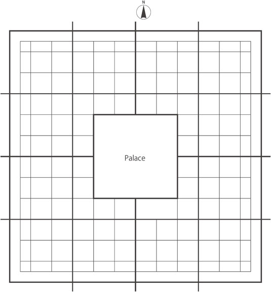
Builders, along with architects/planners, have, from ancient times, repeatedly referred to “Zhōu lǐ” ‘Kaogong ji’ as the only text mentioning the ideal model of a Chinese capital. In the Capital Model, with the palace at the center, “Zhōu lǐ” describes the fundamental model of the ideal Chinese city. However, no city has yet been found with a palace at the center and following precisely the city model given by “Zhōu lǐ”. If we dare list a city that might show at least some resemblance to such a model, Beijing of the Ming and Qing dynasties is the only possible example.
In terms of the relative location of the palace within the city, there are actually two classifications of Chinese capitals: the ‘Center Palace’ type, as described above, and the ‘North Palace’ type. Chang’an (長安) (presently, Xi’an 西安), which became the model for ancient Japanese capitals such as Heiankyo (the present Kyoto(京都)), has its palace on the north side of the city. The origin of the ‘North Palace’ type, the complete shape of which we see in Chang’an, dates back to the capital Pingcheng (平城) (398–493) of Bĕiwèi (北魏, Northern Wei). This type of plan became the model for Sanggyeong Yongcheonbu (上京龍泉府), the capital of Balhae (渤海) (756–785/793–926), and two ancient Japanese capitals (Heijokyo (平城京), the present Nara (奈良), and Heiankyo (平安京)). The author believes that this ‘North Palace’ type of plan belongs to the tradition of nomads on the northern plateau of Mongol. Kaifeng (開封), the capital city of the Song (宋) dynasty, followed the ‘Center Palace’ design formulated by “Zhōu lǐ” ‘Kaogong ji’; Nanjing (南京) and Beijing (北京) followed Kaifeng in succeeding periods, at least in terms of the position of the palace. Dadu (大都) (Khanbaliq) (the present Beijing),B) built by Khubilai Khan (1260–94), represents another variation, where the bell tower and drum tower were placed at the center of the city.
This article clarifies the land division system of the three ancient Chinese capital models — the “Zhōu lǐ” Capital Model (Z), the Chang’an Capital Model (C) and the Dà Yuán (大元) (Dadu) Capital Model (D).
1. Grid systems in the world
Throughout history, city form and urban patterns have appeared to be amorphous, disordered and spontaneously generated; yet architects/planners have often attempted to create the ideal city based on their own theories. Through careful study, it is possible to infer the process of urban formation, analyze the best spatial forms, and interpret the meanings of urban forms that developed over the course of history.1) In this study, the focus is on grid plans, as this makes it easier to understand the principles of spatial structure. Historically, the grid (or gridiron or chessboard) is the most common pattern for planned cities and is universal, both geographically and chronologically. We can see many examples in the East and the West, as well as in the past and at present. The grid itself is widely used as a spatial indexing system when we divide space into a series of contiguous cells. Among a wide variety of grid systems, architects/planners use square or rectangular grids frequently because they are the simplest in works of urban planning.
For architects/planners, the unit of measurement is their most fundamental concern since it is impossible to draw a meaningful line without a dimensional system. In the contemporary world, we have generally adopted the metric system. In earlier times, however, various measurement systems were used, differing from region to region. It is interesting to note that despite these regional differences, many of the basic units of length during these earlier times were very similar throughout most of the world. The reason is that it is (and was) common to use one of the parts of the human body as a basic unit of length. For example, a foot (0.3048 m) nearly equals a chi (尺) (0.3333 m) in China and a shaku (尺) (0.3030 m) in Japan, while a cubit (coudée, elle, cubitus) in ancient Sumer (0.5172 m) equals that of Egypt (0.5235–0.5240 m), Rome (0.4440 m) and hasta (dhanurgraha hasta (0.4800 m), sishu hasta (0.4260 m)) in India and its neighboring region.2)
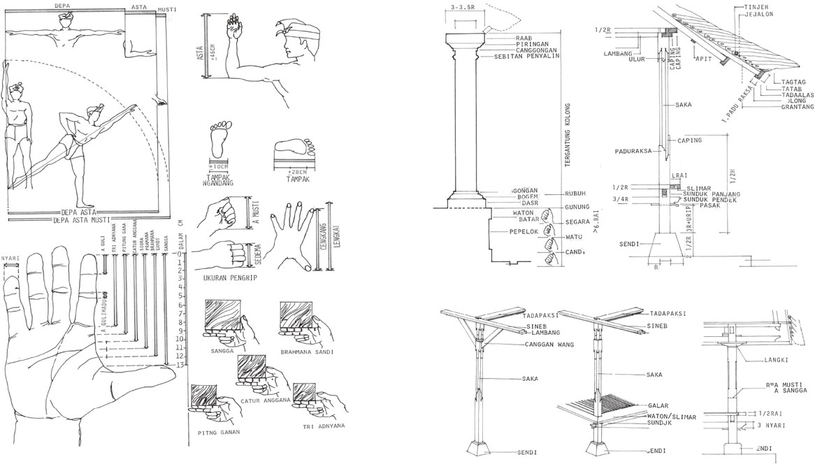
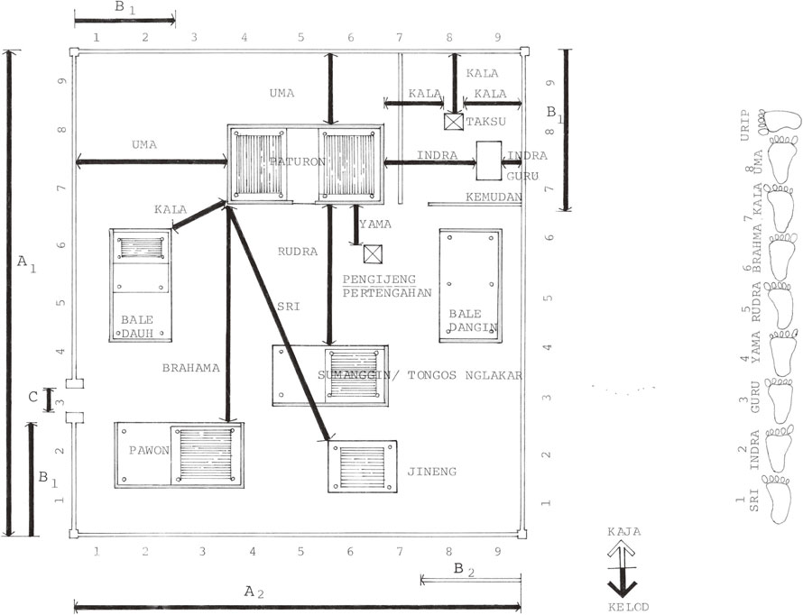
In the course of my work, I interviewed a master of carpenters, called ‘undagi’, on the Island of Bali (Indonesia) to better understand the building process of traditional houses there. Undagi use the length of various body parts (i.e., hands, fingers, and elbows) to determine the size of the building elements (posts, beams, bricks, etc.). The distance between the articulations of the finger is used to decide the size of the cross section of the posts and beams, the length of the elbow, that is, a cubit, is used to decide the length of short members like a diagonal beam, and body length and fathom are used to decide the size of rooms and the expanse of the compound (Fig. 1). In Bali, the house compound consists of several buildings, the positions of which inhabitants decide following the cosmological order, while measuring the distance between buildings by the length of the foot (Fig. 2).
The origin of the grid system in Europe.
The most famous grid city, and one that is referenced on the first page of nearly every textbook on the history of urban planning, is Miletus (Fig. 3), along with the name of the architect Hippodamus (498–408 BCE). Based on the writings of Aristotle, Hippodamus of Miletus is considered the ‘father’ of urban planning and the originator of the grid plan, commonly called the ‘Hippodamian plan’, although there were many grid plan cities built before Hippodamus, and it is widely known that he did not plan the city of Miletus. Planners in Miletus used ‘pes’ as the basic unit of length in dividing the land into individual lots. The area of a street block, which consisted of six house lots, is 100 pes × 180 pes (six house lots, each of which is 50 pes × 60 pes). The pes used in Miletus is called an Ionian foot (=0.294 m); 1/4 pes is a palmus, and 1/4 palmus is a digitus.C)
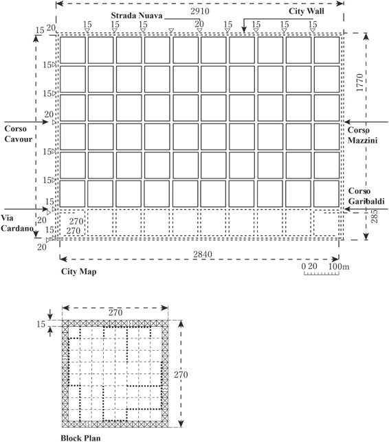
It is well known that the Roman Republic planned its colonies, that is, Roman towns, very systematically, using the grid system. These cities were called ‘Roma Quadrata’, which indicated a square shaped city divided into four districts by a ‘cardo’ (vertical trunk road) and a ‘decumanusu’ (horizontal trunk road), with a forum in the center and four gates in the middle of the four sides. The Roman foot is also called a pes and is used in urban planning. In the case of Ticinum (present-day Pavia, Italy),D) which was constructed in 89 BCE, the total area of the city is 1,770 pedes × 2,910 pedes, with housing lots of 240 pedes × 240 pedes — a unit of area called a heredium (Fig. 4). One hundred heredia, that is, 2,400 pedes (≒708 m) × 2,400 pedes is called a ‘centuria’.
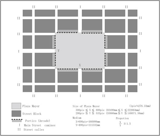
Spanish colonial cities are considered typical examples of cities that used the most integrated grid plan system, though grid plan cities are seen everywhere, as mentioned above. The principles of urban planning are prescribed in Indias Law (Ordenanzas de Descubrimiento, Nuebva Poplación y Pacificación de las Indias, 1573, Phillip II) and we can draw the ideal city plan as a diagram (Fig. 5) with which there is little disagreement among academics. We know of the military engineer/governor José de Escandón y Helguera (1700–1770) who planned and constructed 25 cities with more or less the same plans in the colony of Nuevo Santander (now the State of Tamaulipas in Mexico) following Phillip II’s Ordnance (1573).
Because of such excessive standardization, the plans of Spanish colonial cities appear boring. However, we should take note that not all the city plans necessarily followed the principles of Phillip II’s Ordnance. Shuji Funo & Juan Ramon Jimenez Verdejo3) examined 7,152 maps and drawings related with urban formation which AGI (Archivo General de Indias de Sevilla) has stored, and compared 172 city plans of Spanish colonial cities against the ideal city model. The surprising fact is that there is no single city following the ideal model completely. Planners like José de Escandón adopted a simpler grid system.
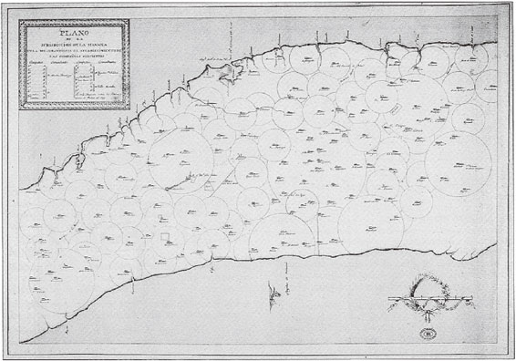
Importantly, we discovered for cities in Cuba an unprecedented land division system entirely different from the grid plan system. Among the 7,152 maps and drawings studied, there were many maps of the Island of Cuba on which multiple circles had been drawn. On such maps, we can identify two kinds of circles, respectively called ‘hato’ and ‘coral’ (Fig. 6). A hato represents an area equal to the area of a circle with a radius of one legua (Spanish league), while a coral represents an area equal to the area of a circle with a radius of two leguas. A legua is a unit of length common in Europe and Latin America. The word originally meant the distance a person could walk in an hour. The legua was originally understood as equivalent to three millas (Spanish miles). The measure varied depending on local standards for the ‘pie’ (Spanish foot), but was officially equivalent to 4,180 meters (2.6 miles) before the legua was abolished by Philip II in 1568.
Cosmology and city form in Asia.
Turning our eyes to pre-modern Asia, we can see that there were two types of capital cities in ancient times. The first mirrors a cosmology that enshrines the seat of royal power or god at its pivot; the second is not governed by such cosmology.
In East, South and Southeast Asia there are planning ideologies and classical literature prescribing the features of the capital cities that are the seat of a ruling power. However, there are no definite documents embodying the ideal concept of an Islamic city.4) It should be especially noted that no definite common relationship exists among the cities and neighborhoods of such countries as the cities of Arabian countries and Indonesia, which has the largest Islamic population in the world. This does not necessarily imply that the Islamic city has no relation to its cosmology. Although there is no particular Islamic thought that a city should represent its cosmology, Muslims believe that the network of Islamic cities centered on Macca (Medina, Jerusalem) forms the Islamic cosmos.
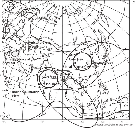
We can divide that part of Asia where cosmology guided the layout of the cities and city life into two regions: India and its peripheral regions, and China and its peripheral regions (Fig. 7).
In India, there have been a number of books written on the ideal city and its architecture, including Arthasastra and Manasara, which were written in ancient times.5) Arthasastra argues for the prosperity of the nation. Its author, Kautilya, was the Prime Minister of the famed Chandragupta I of the Maurya dynasty during the 4th century BCE. His expositions on the ideal form of the capital city are plainly stated, although his work might have been edited between the 2nd century BCE and the 2nd century CE. R. Shamasastry (1916)6) and R.P. Kangle (1960)7) translated the ancient document into English. L.N. Rangarajan (1992)8) later published a new edited translation. This work, the basis of the reconstruction of the ancient city by P.V. Begde (1978),9) W. Kirk (1978),10) and T. Ohji (1991),11) proposes an explanation based on the concept of the ‘Mandala’, which is not only a symbol representing the universe, but is also the spatial pattern of the configuration of the gods.
Manasara is one of the ‘Silpasastra’, which are books related to general science on the art of city planning, architecture, art and sculpture. Collectively these books constitute the Sanskrit literature on these fields. Manasara is the most complete work of ancient Indian literature on architecture among the ‘Silpasastra’, while other works include Mayamata, Casyapa, and Vayghanasa. In Manasara Silpasastra, ‘mana’ means measurement and ‘sara’ is the essence. Thus, ‘manasara’ is the essence of measurement. According to P.K. Acharya, Manasara was completed during the 6th and 7th centuries in South India. Among the many published research studies on Manasara, the works of P.K. Acharya are considered to be encyclopedic.12)
In point of fact, we have found few cities in India that reflect the ideals of Arthasastra or Manasara — the two Hindu classics. The reason is that the Islamic states demolished the Hindu cities and excavation has been limited because of the apparent lack of consciousness of the Hindu cultural past. In addition, the ideal form was not generally realized because of local topographical conditions and challenging political situations.
The relationship of the prevailing cosmology and the formation of settlements provide a broad framework in which to study the diversity of the cities that results from temporal and spatial particularities. It is interesting that the ideal form tends to be implemented more completely on the periphery rather than in the center where the planning idea crystalized. For instance, we see the ideal form of a Hindu city like Angkor Wat and Angkor Thom in Southeast Asia, at the eastern end of the Hindu cultural sphere.
One unique city among the Indian capital cities merits special mention. Cakranegara, in Indonesia, was constructed as a colonial city of the Hindu-Bali kingdom and appears to reflect the concepts of ideal Hindu city planning and the traditions of Hindu society. Cakranegara, in Lombok,E) located east of the Island of Bali, is a little-known grid-based city on which no academic papers had been written before the 2002 publication of a study done by S. Funo (2002).13) The reconstruction plan is the original work of the author. One of the most interesting aspects of the city plan is that the street patterns resemble those of ancient Japanese cities such as Kyoto. Since it has been established that Kyoto was planned following the Chang’an Capital Model, the resemblance of Kyoto to Cakranegara would appear to be among the more exciting topics to be addressed in discussions of the history of Asian capital cities.
The Balinese Hindu kingdom of Karangasem built Cakranegara as a colonial city in the early 18th century. In Sanskrit, ‘cakra’F) means ‘Wheel of Law’ or simply wheel, and ‘negara’ means city (state). It is clear that the name ‘Cakranegara’ is Indian in origin. We can hypothesize that the construction of Cakranegara was based on the ideals of ancient Hindu cities. Nagara-Kertagama,G) the lontar (coconut leaf) chronicle that describes the Javanese Majapahit kingdom in the 14th century was, interestingly enough, discovered within the kraton (palace) of Cakranegara. The central temple of the city is Pura Meru. Meru is the sacred cosmic mountain in the Hindu cosmology. Pura Meru was constructed in 1720 at the center of the city; similarly, Pura Mayura, was built beside the royal palace in 1744. Mayura means peacock, which is the name of an ancient Indian ruling dynasty.
Focusing on the spatial formation of the city, it is clear from the map drawn in 1942 (Fig. 8)H) by the Land Survey Department of the Japanese military headquarters during the Japanese occupation that Cakranegara exhibited a distinct grid pattern in the layout of its streets at that time.
Cakranegara was planned with three hierarchic levels of streets (Fig. 9). The streets are categorized as marga sanga, marga dasa and marga according to their width, with marga sanga being the widest.I) Sanga is the number 9J) and dasa is the number 10. Marga sanga are the two streets that cross through the center of the city.K) These two streets are exactly oriented to the cardinal directions running vertically (north-south) and horizontally (east-west) and divide the city into four quarters. Marga dasa divide these quarters into urban blocks, while marga are the streets that run within the urban blocks.
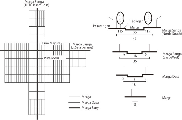
The measured width of the marga sanga running east-west is ≒36.50 m, and that of the marga sanga running north-south is ≒45.00 m. The width of individual marga dasa among the twelve marga dasas measured varies from 12.86 m to 21.60 m. Given the disparity in the individual widths, the average value of 17.20 m is not of much significance. However, if we consider those streets that show a clear grid structure as well as the remains of old walls, we see that the three levels of the streets of Cakranegara were planned with widths of approximately 8 m, 18 m and 36 m (and 45 m).
The planned execution of Cakranegara is most evident from the dimensions of the pekarangan (house plot). The average length of the plot along the east-west axis is 26.43 m, with individual dimensions ranging from a maximum of 30.44 m to a minimum of 25.08 m. The average width along the north-south axis is 24.96 m, with 27.03 m and 21.55 m the maximum and minimum widths, respectively. If we take the most frequent dimensions and round them off in meters, the east-west plot dimension is 26 m, while the north-south dimension is 25 m.
According to the elderly residents living in the center of the city, the planning dimension of a pekarangan was 25 m by 25 m. The measurement instrument used was the tomba, a rod approximately 2.5 m in length. Ten tomba equal 25 m. A tagtagan is two tomba, or about 5 m. Further inquiries revealed that a pekarangan was a square plot with an area of six or eight are (600 m2 or 800 m2). However, measurements show that the plots were not exact squares as the elderly residents believed them to be. Nevertheless, if the tomba was used as a measuring rod, it would make sense that the plots were in fact square. At any rate, it is certain that a standard fixed dimension was used to mark the housing plots. According to the measurement data above, the area of the pekarangan averaged 26.43 m × 24.96 m (659.69 m2) or approximately 25 m × 26 m (650 m2), which is generally in accordance with what the elderly residents told us.
The urban block enclosed by the marga dasa is divided into four smaller strips of blocks crossed longitudinally by margas. Each strip of block is then divided in a back-to-back manner giving 10 housing plots on either side, or 20 plots in the strip block. If we take the measure of a tomba as 2.5 m, the width of the plot in the north-south direction is 10 tomba, or 25 m. Further, the length of the block enclosed by the marga dasa would be 10 times the width of the housing plot, or 250 m. The meaning of dasa in Sasak is 10, and it seems that the meaning is derived from this standard of 10 used in the measurement employed in planning the divisions of the urban blocks. The width of the block along the east-west axis is the plot length 26 m × 2 × 4 + the width of the marga, 8 m × 3 = 232 m. If we add to this length the width of the marga dasa, which is 18 m, the width of the urban block measured from center to center of the marga dasa becomes 250 m. Thus, it can be considered that the planned dimension of the urban block is a square of 250 m × 250 m. In this module, the north-south dimension is the inner clear dimension of the block, while the east-west is a center-to-center measurement. In any event, it is clear that architects/planners used a modular system of 10 × 10 and 100 × 100, with the tomba as the basic unit of measurement, in planning the housing plot and the urban block.
Observation of street patterns and analysis of planning dimensions indicate that the block enclosed by the marga dasa is the unit of a residential neighborhood. Another basis for this assumption is that the marga dasa defines the boundary of the present spatial unit, the karang.L)
According to the elderly residents, the basic neighborhood unit is made up of two groups of 10 dwelling plots, each lining either side of the marga running north-south and facing each other. This cluster of 20 plots arranged along the two sides of the marga comprises the basic unit known as a marga. Two marga make up a unit called a kriang. In Bali, kriang is the title of the chief of a community unit, or ‘banjar’. Further, two kriang comprise 80 dwelling plots, and make up a neighborhood district known as a karang. An interesting fact here is that this street block formation resembles that of Heiankyo (presently, Kyoto), which was established following the Ancient Chinese Capital Model (C).
2. “Zhōu lǐ” capital model — Archetype of the Chinese ideal city
“Zhōu lǐ”, which describes the ideal administrative system of kingdoms, is commonly said to have been written by Dan, Duke Wen of Zhou (周公旦), who was a member of the royal family of the Zhou (周) dynasty. It is also said that Emperors of subsequent dynasties tried to follow “Zhōu lǐ”. Many scholars have reconstructed the ideal capital city plans according to “Zhōu lǐ” ‘Kaogong ji’. However, because the book’s sentences relating to city planning, street pattern, block formation, and so on are relatively short (less than 7,000 Chinese characters), a number of different diagrams have been drawn over time. Complicating matters is the fact that there are inconsistencies in the contents of the text.
‘Kaogong ji’ jiang ren ying guo.
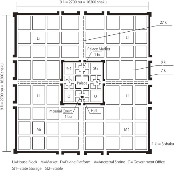
“Zhōu lǐ” ‘Kaogong ji’ contains three paragraphs referring to ‘shu jing’ (匠人 master builder or planner/architect) but the most important paragraph is the Si shu jing zhu ji zheng (匠人営国) paragraph; the paragraph most frequently referred to includes the features described below. Here the author cites essential parts of the relevant text, while omitting others for detailed analysis. Li (里) is a unit of length and ki (軌) is the width of carriages, i.e., the breadth between wheels, which is estimated to be about eight feet.
-
匠人営国 Jiang ren ying guo: Master builder who constructs the city.
-
方九里 fang jiu li: 9 li × 9 li square.
-
旁三門 pang san men: Sides with three gates.
-
国中九経九緯 guo zhong jiu jing jiu wei: Nine vertical streets and nine horizontal streets within the city.
-
経塗九軌 jing tu jiu gui: The width of the vertical axes is 9 ki (wheels).
-
左祖右社 zuo zu you she: Ancestral shrine (Mausoleum) to the left, divine worship (Soil & Grain platform) to the right.
-
面朝後(后)市M) qian chao hou shi: Imperial Court in front (of Imperial Palace), markets at the back.
-
市朝一夫N) shi chao yi fu: Size of palace and market 1 li × 1 li.
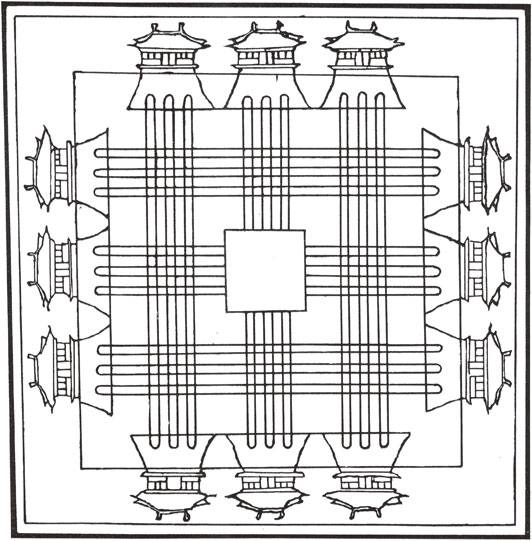
Many rulers and their architects/plannersO) attempted to construct the ideal city from the description of ‘Kaogong ji’ as a means of expressing their legitimacy. Confucian scholars proposed plans in a number of different manners, perhaps the most representative one being Sān lǐ tú (三礼図), which was drawn during the Song dynasty (960–1279 CE) (Fig. 10). The first thing we notice in the diagram is that one street has three lanes. This might be an attempt to interpret the idea of integrating ‘three gates on one side and nine lanes’ with ‘nine vertical streets and nine horizontal streets within the city’ mentioned in the text. The author, however, considers this interpretation to be rather unnatural.
The basic problem is the inconsistency between ‘Square: 9 li × 9 li’ and ‘Sides with three gates’. If we follow the primary rule of ‘sides with three gates’, the entire city is divided into 4 × 4 = 16 blocks. However, it is more reasonable that the area is divided into 9 × 9 = 81 blocks based on the ‘1 li × li’ unit area, as the size of a square li (equal to 300 bu × 300 bu) is a basic unit of area in the ancient system of land division called ‘jǐngtián zhì (井田制)’.
If we suppose that the city has nine vertical streets and nine horizontal streets, excluding the two streets (ring roads) running along the city wall (that is, if the two ring roads are not counted among the nine), then the city area is actually divided into 10 × 10 = 100 blocks. If we include the number of ring roads (i.e., two) in the nine, then the entire city is divided into 8 × 8 = 64 blocks. Thus, if we follow the 9 li × 9 li division, the city has eight vertical streets and eight horizontal streets, excluding the ring roads, or 10 vertical streets and 10 horizontal streets, if we include the ring roads.
In the latter case (9 × 9 division), it is not possible to lay out the gates at regular intervals. It is necessary to divide one side into four equal segments in order to lay out gates at the same interval. The crucial question, then, is which feature should we take as the first priority, the 8 × 8 = 64 division or the 9 × 9 = 81 division?
To solve this inconsistency, a 12 × 12 division model based on a common multiple of four is convenient. We know the architects/planners who designed Amarapura and Mandalay in Myanmar in the mid-19th century used a fundamental grid with 12 × 12 cells (Fig. 11). It may be that they were also worried about inconsistency among the features and found the same solution.
Chinese scholars interested in ancient urban planning continue to propose reconstruction models based on “Zhōu lǐ” ‘Kaogong ji’. The most noteworthy among recent efforts is the ‘Model A’ proposed by He Ye Ju (賀業鉅) (1985),14) which restores a detailed plan of the blocks (Fig. 12).
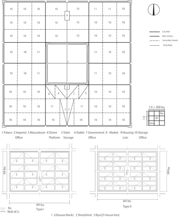
He Ye Ju adopts the 9 × 9 = 81 division system as his basic grid. In this case, it is impossible to allocate all the gates on the grid line at the same interval. As seems proper, the main gate is located at the center of each side; He Ye Ju then places the other two gates at the middle points between the center and the end of the side. He considers his model to be consistent with the nine vertical streets and nine horizontal streets system that includes the wall streets. The problem is that his model generates a new block type of 300 bu × 450 bu in addition to the unit block (300 bu × 300 bu), although two types of blocks may be acceptable since Chang’an actually has five different types of blocks. In his reconstruction of a detailed block plan, He Ye Ju references other historical documents besides “Zhōu lǐ” ‘Kaogong ji’.
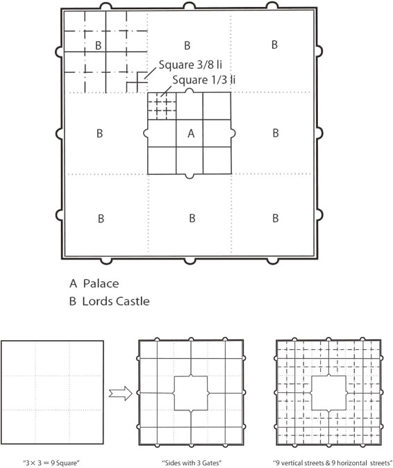
Other models have been proposed by Wang Shi Ren (王世仁) (2000)15) (Model B, Fig. 14) and Zhang Rong (張蓉) (2010)16) (Model C, Fig. 15). Wang Shi Ren basically follows He Ye Ju’s Model A, but does not count ring roads, on the premise that the main central street has three lanes. In addition, he lays out mausoleum, soil and grain, Imperial Court and market place following the cited features precisely. Zheng attaches greater importance to the features, Dividing the city into nine districts, and ‘Nine Lords rule the districts (九分其国, 以為九分, 九卿治之)’ mentioned in the latter part of ‘Kaogong ji-jiang ren ying guo’. Consequently, he selects the nine square model (3 × 3 = 9) and sets the gate at the center of 1/3 of each side. The distance between gates is the same. As for the ‘nine streets and nine streets’ aspect, it is reasonable that each block has three streets. The 1/9 block in Zheng’s Model C is divided into 16 = 4 × 4 lots with a square area of 225 (300 × 3/4 = 225) bu. The city consists of 12 × 12 lots, which is similar to the pattern of Amarapura and Mandalay (Fig. 11) mentioned above.
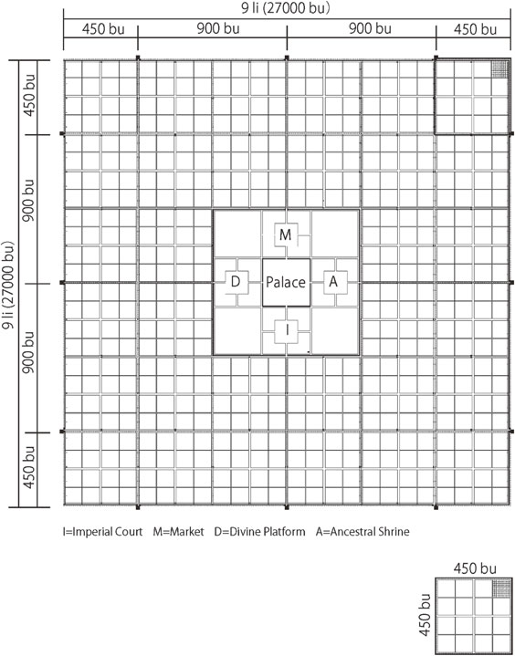
One can thus conclude that reconstruction plans differ depending on what elements or rules are regarded as most important, as reviewed in the theories described above. I raise here one more model (Model F) (Fig. 15) that shows no apparent inconsistency with “Zhōu lǐ”. Model F essentially follows the architects/planners of Amarapura and Mandalay and represents a compromise between Models A, B, and C. Its essential characteristics can be summarized as follows:
-
a.
Model F follows ‘square 9 li (方九里)’ and a 1 li (300 bu × 300 bu) grid.
-
b.
Model F follows ‘sides with three gates (旁三門)’ as well as Model B, which is based on a nine square (3 × 3 = 9) plan, with one of the gates placed at the center of the block.
-
c.
Model F follows ‘nine vertical streets and nine horizontal streets within the city (国中九経九緯)’ without the wall streets. Each block (1/9) has three vertical streets and three horizontal streets. The streets running by the sides of the central block are included among the nine streets.
-
d.
Each block is divided into 16 = 4 × 4 bo; that is, the block consists of four bo (450 bu × 450 bu) divided into four sub blocks.
-
e.
A bo (450 bu × 450 bu) is divided into a 10 × 10 grid; that is, one bo square block consists of 100 (10 × 10) lots making each lot 45 bu × 45 bu.
-
f.
Model F follows Model B in that it has the mausoleum on the left hand side and the soil & grain platform on the right (左祖右社). Likewise, the Imperial Court is in front of the emperor’s palace and the market behind it (面朝後市).
-
g.
Model F follows Model A with respect to the spatial formation of the palace.
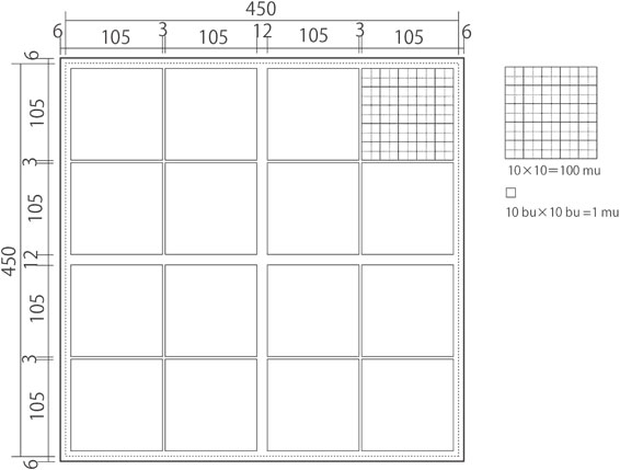
The Bo (坊) model is proposed here, which is useful for comparing Model F with the Chang’an Capital model and the Dadu Capital model. Mu (畝 100 mu = 100 bu (歩) × 100 bu) has been used as a unit of area measure in China from ancient times. Under the ancient well-field system (井田制), 900 mu equals a square li (300 bu); however, 450 bu × 450 bu is used as a unit of bo in ‘Model F’ (Fig. 15). The premises are as follows:
-
h.
An area of 100 bu × 100 bu = 100 mu is used as a unit of area.
-
i.
The width of a street 9 ki(wheel) wide is 72 shakus(feet) and that of a wall street is 7 ki = 56 shakus, following 1 ki = 8 shakus. It is assumed that 56 shakus = 9.33 bu + the thickness of the wall equals 12 bu.
-
j.
A bo is divided into 4 and 16 sub areas by crossroads, the width of each being 12 bu. A square unit will be 213 bu × 213 bu or 105 bu × 105 bu.
-
k.
A square of 105 bu × 105 bu might be divided in several ways. If we assume the width of the crossroad is 5 bu, the area of a sub district will be 50 bu × 50 bu = 25 mu, and total area will be just 100 mu. The total area of a bo consists of 16 sub districts that will be 400 mu × 4 = 1,600 mu.
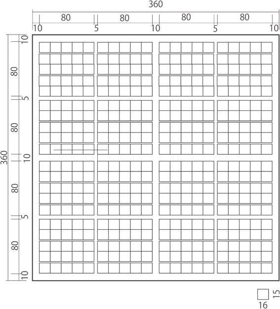
The detailed division and land division system described above demonstrate that the “Zhōu lǐ” Capital Model F follows a consistent system and logic, so I believe that no additional discussion of the “Zhōu li” Capital Model will be needed. “Zhōu lǐ” Capital Model F will be re-named as the Chinese Capital Model (Z) as an archetype later in this paper.
3. Chang’an capital model
Chang’an, the capital of the Suí (隋) and Táng (唐) dynasties, whose population of roughly one million was comparable to that of Bagdad at its zenith in the 7th century, is quite famous. However, while we know much about its history and space formation, there are still many riddles left to solve.
Chang’an is unique in the history of city planning. The genius Yǔ wén Kǎi (宇文凱) (555–612 CE) planned the city as the ideal land of Buddha as ordered by the Emperor Wen (文帝). How he decided the size and space formation of the capital is our concern here, and we have already several reconstruction plans based on archaeological surveys. The one (Chang’an Capital Model A) reconstructed by the Japanese scholar Takeo Hiraoka (平岡武夫) (1956)17) appears to be generally accepted by Chinese scholars, but it is not considered to be the final one. I will propose what I consider the most feasible plan next.
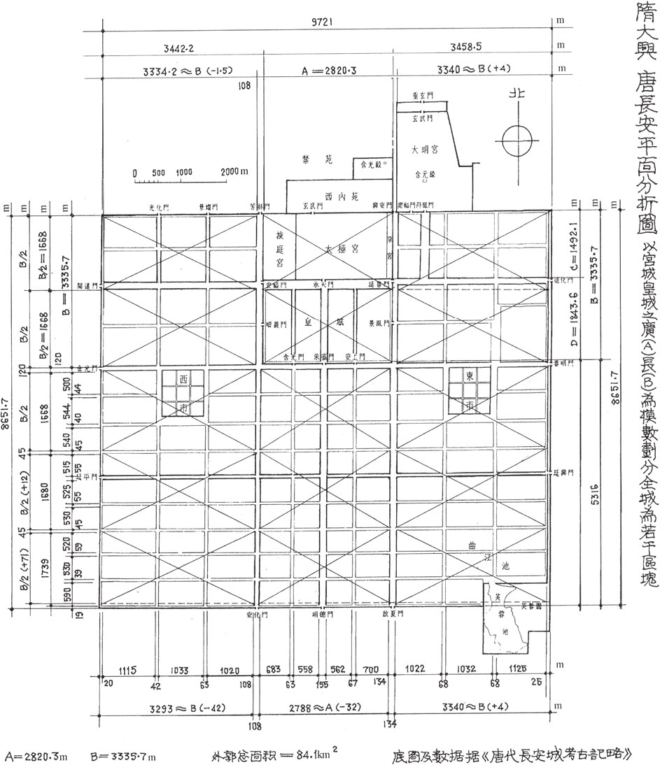
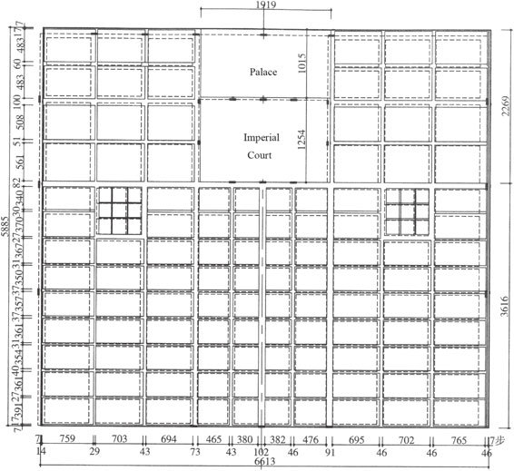
The measurements given by the authority of archaeological surveys in China records the size of Chang’an as follows: the east-west width = 9,721 m (6,617.43 bu = 33,087.1 syaku); the north-south width = 8,651.7 m (5,885.51 bu = 29,447.6 shaku). Fu Xi Nian (傳熹年) (2001)18) shows the measure of parts and the proportional relationships between the segments of the two sides (Fig. 17).
The basic grid — A primary division.
The reconstruction plan of Fu Xi Nian18) shows firstly that the width of the districts next to the Imperial Palace on both sides is the same (B) and that the length of the southern district below the Imperial Palace is one and half times the width (B). The first clue is the size of the Imperial Palace. One old document mentioned the width (east-west) (A) as 5 li 115 bu (1,915 bu) and the length (south-north) (B) as 3 li 140 bu (2,210 bu). The actual measurements are A = 2,820.3 m = 1,918.6 bu and B = 3,335.7 m = 2,269.2 bu. Furthermore, the south-north length of the Inner Palace is 1,492.1 m = 1,015.0 bu. The numerical values differ with the measuring points. One reason for this is likely derived from the margin of error in construction, but whether the planner used a single grid system or a double grid system, and what unit of measurement the planners/architects used, are essential elements.
We should at least distinguish the size of a block and the width of the streets separately. Actual measurements are rather uneven, so we can only guess that Yǔ Wén Kǎi decided firstly on the sizes of the larger proportions of the city — the sizes of the Imperial palace, markets, major streets and so on — following a single grid system.
It can be supposed that Yǔ Wén Kǎi determined the size of the Inner Palace (1,000 bu × 2,000 bu) first, judging from the actual east-west measure (960 bu–1,015.0 bu and south-north 1,900 bu–1,950 bu). If the width of the vertical streets adjacent to the Imperial Palace is 100 bu, the distance between the centers of streets on both sides will be just 2,000 bu × 1,000 bu. In addition, the horizontal width (B) of the large blocks located on both sides of the Imperial Palace are divided into three. Thus, B is supposed to have been set as 750 bu × 3 = 2,250 bu. Both parts of the large blocks next to the Imperial Palace are planned as a 2,250 bu × 2,250 bu square. The breadth of the special east-west street between the Inner Palace and the Imperial Court will be 250 bu, while the length of the Inner Palace and Imperial Court will each be 1,000 bu. As for the southern district below the Imperial Palace, if the north-south length of 3,375 bu (1.5 B) is divided into nine segments, then the width of each segment will be 375 bu (750/2).
It can be confirmed that Yǔ Wén Kǎi uses simple numbers like 1,000 bu, 2,000 bu, 750 bu, 500 bu and 250 bu (Fig. 18). The reasoning above is very simple and convincing, but the problem is that the total south-north length is shorter than the actual measurement. The calculated measure is 2,250 bu + 3,375 bu = 5,625 bu, which is 164.52 bu shorter than the measured value of 5,889.52 bu.
The second clue comes from the following sequence of construction steps as clarified by Japanese historian Tatsuhiko Seo (2001),19) who based his conclusions on old documents. The description is widely accepted by the academic society of Chinese history.
-
a.
First, the position of the Inner Palace and central axis was decided.
-
b.
Second, the walled forbidden garden and Imperial Court were constructed.
-
c.
Third, six trunk streets (六道) that connect the gates were constructed. Three vertical trunk streets run on the central axis and on both sides of the Imperial Palace. Three horizontal trunk streets run through the center of the Imperial Palace, along the southern side of the Imperial Court and through the center of southern outer block.
-
d.
Fourth, nine vertical streets and 12 east-west streets (六道), including six trunk streets, were constructed.
-
e.
Finally, the outer walls were constructed.
To sum up, the basic principles of the reconstruction described above are as follows:
-
i.
Very simple multiples of bu such as 1,000 bu, 2,000 (2 × 1,000) bu, 500 (1/2 × 1,000) bu, 250 (1/4 × 1,000) bu, and 750 (3/4 × 1,000) bu are used as the unit of measure.
The size of the palace (2,000 bu × 1,000 bu) and the location was decided first (a), then the Imperial Court (2,000 bu × 1,250 bu) was constructed (b). The unit of measurement is 250 bu.
-
ii.
The city consists of two sectors, the north block, including the Imperial Palace, and the south block, which includes the east and west markets (b). The size of the upper part of the bo street blocks next to the palace and Imperial Court is a planned square (1,250 bu × 1,250 bu).
-
iii.
Six trunk streets divide the city into 12 (16-4) different districts (c). Three horizontal trunk streets and three vertical trunk streets divide the capital into 16 districts, but the palace and Imperial Court occupy four districts. The districts are divided into five bo street blocks, as the same bo size is symmetrically allocated. The street blocks (bo) are 5,500 bu × 750 bu (A), 625 bu × 750 bu (B), 375 bu × 750 bu (C), 375 bu × 550 bu (D), and 375 bu × 450 bu (E).
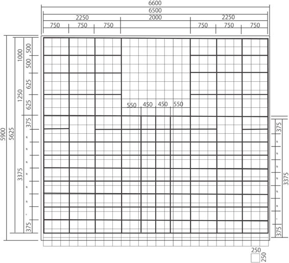
There is also a reconstruction plan proposed by Wang Hui (王暉) (2008)20) based on Fu Xi Nian (2001) (Fig. 18).18) It is a revision of the plan established by Takeo Hiraoka’s generally accepted Plan of Chang’an (Chang’an Capital Model A). Wang Hui presumes that the 47 bu width of the vertical streets is unnatural. However, the south-north length in the revised plan is shorter than the actual survey plan. Therefore, Wang Hui made an additional amendment to his revised plan (Fig. 19). Nevertheless, it is clear that his plan is different from the original plan. The widths of the streets vary because he tries to fit the data to that of the archaeological survey. If I were to revise the reconstruction plan proposed by Wang Hui, I would assume the width of an east-west street to be 50 bu (rather than 40 bu), except for the trunk street (100 bu). In this way, we can arrive at a very systematical reconstruction plan (Chang’an Capital Model B) (Fig. 20).
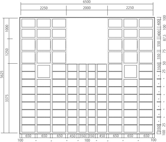
The reconstruction plan previously established by many scholars consists of five kinds of bo — 400 bu × 650 bu, 550 bu × 650 bu, 350 bu × 650 bu, 350 bu × 450 bu, and 350 bu × 350 bu, where the width of the east-west streets is 50 bu, except for the trunk streets. However, I have great difficulty accepting this reconstruction because the breadth of the vertical streets is not the same 100 bu as judged from the actual measurement. We notice that there is a hierarchy in street width. In the case of vertical streets, 42–68 m (28.6–46.3 bu), and in the case of horizontal streets, 39–55 m (26.5–37.4 bu). Moreover, the sizes of the various bo are larger than those in the reconstruction plan. The bo located beside the Inner Palace have a size of 483 bu × 694–765 bu (400 bu × 650 bu); bo located beside the Imperial Court are 508–561 bu × 694–765 bu (550 bu × 650 bu).
We thus reject the Chang’an Capital Model B and propose a far more consistent reconstruction plan (Chang’an Capital Model F) (Fig. 21) with the following properties:
-
a.
The breadth of the trunk street is 100 bu.
-
b.
The breadth of the street alongside the city wall, including the thickness of the city wall, is 50 bu. The east-west length of the left and right large blocks next to the Imperial Palace, which are divided into nine bo, will be 2,200 bu (2,250 bu–50 bu = 2,200 bu = 700 bu + 50 bu + 700 bu + 50 bu + 700 bu, where the width of a bo = 700 bu, and the width of the street = 50 bu).
The south-north length of 2,250 bu can be divided into reasonable segments: 450 bu + 50 bu + 450 bu + 100 bu + 550 bu + 50 bu + 550 bu + 50 bu.
-
c.
The size of the bo adjoining the Inner Palace is 450 bu × 700 bu and that of the bo adjoining the Imperial Court is 550 bu × 700 bu.
-
d.
The width of all south-north streets is set at a measure that is a half the width of the trunk street, which is 50 bu. The east-west lengths of the large blocks just below the Imperial Court are divided into four bo: 100 bu + 475 bu + 50 bu + 375 bu + 100 bu + 375 bu + 50 bu + 475 bu + 100 bu.
-
e.
The breadth of the east-west minor streets below the Imperial Palace is 25 bu. The bo just south of the Imperial Court will be 350 bu × 475 bu and 350 bu × 375 bu. Bo located southeast and southwest will be 350 bu × 700 bu.
The only ambiguous element in this Chang’an Capital Model F is the distance between the Imperial Court and the bo area; that is, the width of the main horizontal street. If the width of the main street is precisely 100 bu, it is necessary to move the line from the basic line (α = 37.5 bu, β = 75 bu). However, gap γ is still left at the south end (γ = 97.5 bu + 50 bu).
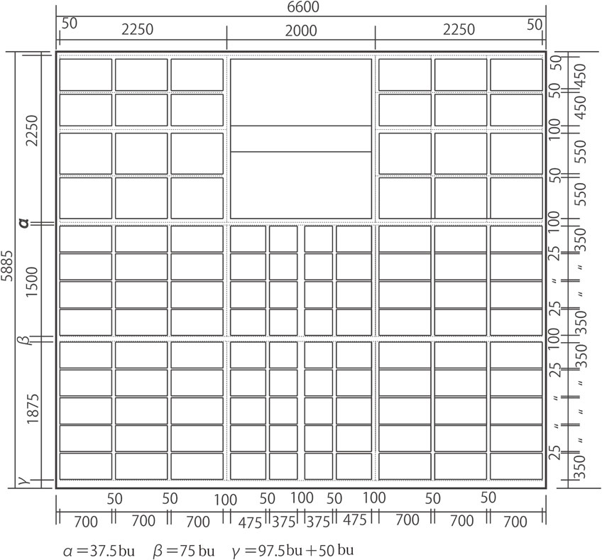
Land division of bo (street block).
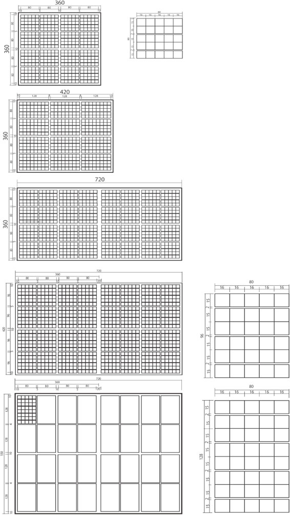
The division of bo into sub blocks and house lots can be demonstrated with an example. Consider a bo of size 375 bu × 750 bu. This is generally the most common bo. We can easily hypothesize that the unit of area is based on a unit of 1 li (360 bu) × 1 li (360 bu) = 1 fu (夫). Considering the width of a street and the size of the basic grid to be 375 bu × 750 bu, the area of a bo might be 1 li (360 bu) south-north × 2 li (720 bu) east-west. If we hypothesize that the widths of streets are 30 bu (south-north) and 15 bu (east-west), the size of a bo, the 375 bu × 750 bu is clearly reasonable.
The area of a bo unit is a square of 360 bu × 360 bu; 1 mu = 240 square bu. It is supposed that the pattern of bo division varied, but according to old documents, a 4 × 4 = 16 division and a 4 × 3 = 12 division by crossroads were often used. The shape of a house lot, the size of which is 1 mu = 240 square bu, is also assumed to vary — for example, 4 bu × 60 bu, 8 bu × 30 bu, 12 bu × 20 bu, 15 bu × 16 bu, and so on. The most square-like shape of 15 bu × 16 bu division might have been used most commonly.
The bo adjacent to the Imperial Palace consisted of four and 16 sub street blocks, while the bo below the Imperial Palace consisted of two and six sub blocks.
It is now possible to show the most feasible bo model (Fig. 22). Taking the thickness of the bo wall into account, a bo (360 bu × 360 bu) is reduced to 340 bu × 340 bu, which is divided into four sections by crossroads (width = 10 bu) and 16 sub-blocks (80 bu × 80 bu). One-sixteenth of a bo = 25 mu (5 × 5), 1/4 bo = 100 mu, so a bo = 400 mu. The smallest unit bo (360 bu × 360 bu) consists of four street blocks (100 mu). The basic unit of area measure is based on the 1 mu = 240 bu × 1 bu system. Other types of bo can be divided in the same way. Figure 23 shows all five types of bo.
Later in this paper, the Chang’an Capital Model F will be re-named the Chinese Capital Model (C), as Variant I.
4. Dà Yuán (Dadu) capital model
Dadu or KhanbaliqP) (present-day Beijing, the capital of China) was originally built as the capital of Dà Yuán (Yehe Yuan) Ulus (Yuan dynasty), the Mongol Empire founded by Kublai Khan. In 1264, Kublai Khan ordered his chief architect/planner, Liu Bingzhong (劉秉忠), to design the city. Liu’s student, Guo Shoujing (郭守敬), Muslim Ikhtiyar al-din (他黒迭児), and many talented others participated in constructing Dadu. The main Imperial Palace was built from 1274 onwards. Following the establishment of the Yuan dynasty in 1271, Kublai Khan proclaimed the city as his capital under the name Dadu, although construction was not completed until 1293.
People in general believe that the design of Dadu followed several of the rules laid down in “Zhōu lǐ” ‘Kaogong ji’, such as “nine vertical and horizontal axes”, “palaces in front, markets at the back”, “ancestral worship to the left, and divine worship to the right.” This belief is challenged below.
Planning principles — Basic grid.
Fu Xi Nian (2001)18) analyzed the measurement data reported by the archaeological survey authorities and proposed his hypothesis regarding the planning of Dadu (Fig. 24a,b). He suggests that Dadu was planned using the size of the palace as a reference. He insists that the east-west length of Dadu city (6,672 m) equals 9 × A (A = the east-west length of palace), that the south-north length = 5 × B (B = the south-north length of the palace), and that 5 × B = 4 × C, where C = the distance between gates. This kind of proportional relationship gives us hints to reveal the modular coordination.
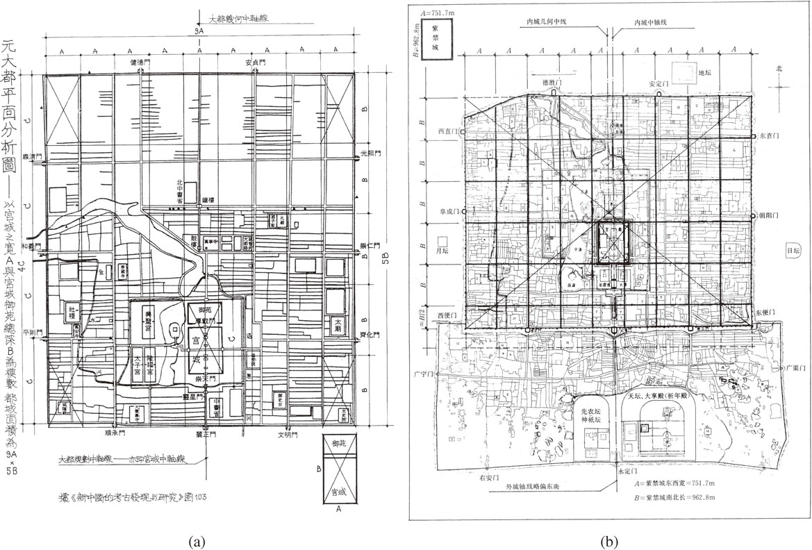
The actual measure of horizontal length is 6,673.419 m, which converts to 18 li (4,320 bu; 1 li = 240 bu).Q) A = 480 bu. Vertical length varies from 7,521.80 m–7,651.17 m, which converts to 19.83–20.18 li. Therefore, we can suppose that the planned measure is 20 li (20 li × 240 bu = 4,800 bu) and easily establish that a very simple grid system based on a square of size 480 bu × 480 bu was used (Fig. 25).
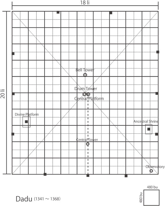
In addition, we find that the drum tower is located at the center of the capital, reflecting the idea that it was very important for the ruler to control the time system. The bell tower was also located on the vertical axis at the center. The distance between the two towers is 193.76 m = 125.82 bu. Moreover, all the gates are on the grid line and the intervals between gates are the same 5:5:5:5 li for the east and west walls, 4:5:5:4 li for the south wall, and 6:6:6 li for the north wall. Therefore, there is no doubt regarding the simplicity of the plan in its use of the 480 bu grid system.
In reality, the vertical axis of the center was moved 129 m = 83.77 bu westward from the central axis of the palace because the ground was so soft that the east wall had to be moved inward. The drum tower and bell tower were moved to the present place, on the central axis of the palace, during the Ming dynasty.
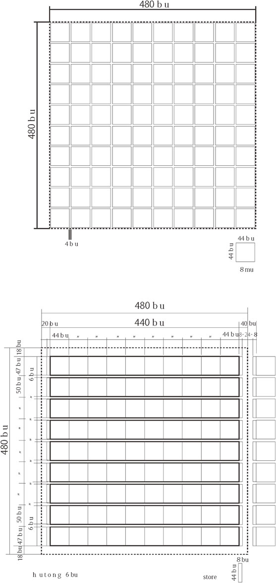
Old documents state that the ‘width of the large streets is 24 bu and that of the small streets is 12 bu’, the ‘breadth of a hutong (lane) is six bu’, and that ‘the largest area of house lots is limited to less than eight mu’. Since 1 mu = 240 square bu = 240 bu × 1 bu = 240 × 1.58 m (1.54 m) × 1.58 m (1.54 m) = 599.14 (569.18) m2, then 8 mu = 4,793.09 (4,553.47) m2.
Keeping the number of units of measure above in mind, it is possible to determine the street system and block formation. Large trunk streets are distributed in a systematic manner. Looking at the present map of Beijing and the Qianlong Peking Map, we notice many blocks to be of the same size. Checking the distance between hutong (horizontal lanes), one gets more or less 50 bu (79.0 m) from center to center of the lanes. The widths of the other streets (24 bu, 12 bu) are also confirmed. As for the horizontal streets, a length of 440 bu is common.
As the width of a hutong is six bu, the south-north length of a house block will be 44 bu (69.52 (67.76) m). Though the length of 44 bu may initially appear meaningless, a crucial hint to solve the numerical system emerges when ones notes that the east-west length of a hutong is about 440 bu (695.2 (677.6) m). If 8 mu (4,553.47 m2) is divided by 44 bu (67.76 m), the result is 67.20 m, which nearly equals 44 (67.20 ÷ 1.54 = 43.64) bu. Furthermore, the square root of 8 mu = 240 bu × 8 = 1,920 bu is 43.82 bu, and 44 bu × 44 bu = 8 mu, which is the unit of land for distribution. The area of a house block is 44 bu × 44 bu = 8 mu, or 10 land lots (44 bu × 44 bu) (Fig. 26).
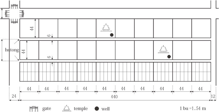
Eight mu is the upper limit of land, so an area of 8 mu was divided into smaller lots. In fact, land of this size was usually divided into 8 or 10 lots. If it is divided into 10 lots, a housing block will consist of 100 (10 × 10) house lots. This establishes that the space formation of street blocks is based on a simple land division system (Fig. 27).
The idea of the plan of Dadu.
Where did the idea of the Dadu capital plan come from? What kinds of planning principles did the architects/planners follow? The previous summer, they had also planned and constructed Xanadu (Shangdu (上都)), though a discussion of the idea and method of their urban planning is left for another paper.
I consider the Dadu plan to be the third model (Chinese Capital Model D), different from both the “Zhōu lǐ” Capital Model (Chinese Capital Model (Z)) and the Chang’an Capital Model (Chinese Capital Model (C)). Below is an attempt to compare the Dadu Capital Model (D) with the “Zhōu lǐ” Capital Model (Z):
-
a.
‘Square 9 li × 9 li’: D does not follow Z: The horizontal length is 18 li and vertical length is 20 li (1 li = 240 bu). However, a simple numerical system is followed.
-
b.
‘Sides with three gates’: D basically follows Z, the but north side lacks one gate.
-
c.
‘Nine vertical and horizontal axes within the city’: D basically follows Z, but it is difficult to determine whether this idea was in the planners’ minds. A simple 480 bu × 480 bu grid was adopted.
-
d.
‘The width of vertical axes is nine ki (wheels) wide’: It is difficult to judge whether D follows Z, but 40 bu for large streets and 6 bu for hutong were decided first.
-
e.
‘Ancestral worship (Mausoleum) to the left, divine worship (Soil & Grain platform) to the right’: D clearly follows Z. It seems to follow “Zhōu lǐ” and ‘Kaogong ji’ faithfully; that is, in the east and the west the layout is different from the layout in front of palace, as in Nanjing and Beijing during the Ming dynasty.
-
f.
‘Imperial Court at front, markets at back’: The court is in front of the emperor’s palace and the market is behind it’: D follows Z.
-
g.
‘Size of palace and market is 100 bu × 100 bu’: It is not clear whether D follows Z.
It can be said that the Dadu plan basically follows “Zhōu lǐ” ‘Kaogong ji’. However, the Dadu Capital Model (D) is different from the “Zhōu lǐ” Capital Model (Z) and the Chang’an Capital Model (C) in that in the center of Dadu is the drum tower rather than the palace; the palace here is in the southern part of the capital.
Beijing.
The last Yuan emperor fled north to Xanadu while the Ming razed the palaces of their capital to the ground. The capital of the Ming dynasty was then laid at Nanjing, which was constructed following the “Zhōu lǐ” Capital Model (Z). Later, the third emperor of the Ming dynasty moved his capital north to the ruins at Dadu. He contracted the northern area of the Mongol city and added a new and separately walled district in the south. The initial plan was to enclose the capital threefold, but the plan was never completed for financial reasons. As a result, Beijing remains the most suitable exemplar of a Chinese capital following the “Zhōu lǐ” Capital Model (Z).
Summary
Although it can be extremely difficult to understand and interpret logically how urban tissues are formed, architects/planners do, in fact, make plans to construct buildings and cities according to persuasive theories. One of the most important matters for architects/planners is the unit of measurement.
This article seeks to leave for the record the following observations, principles and theories:
-
1.
Various measurement systems have been used in different regions of the world; however, basic units of length are very similar all over the world, as the length of some part of the human body has commonly been used to define the fundamental unit of length.
-
2.
Grid systems are universal both geographically and chronologically. We can see many examples in the East and the West, in the past and at present.
-
3.
On the other hand, cosmological order is considered to be one of the principle factors for urban planning in the pre-modern world. There are essentially two types of cities: The first mirrors a cosmology that enshrines the seat of royal power at its pivot; the second is not governed by such cosmology. We can divide Asia into two regions — one where the cosmology guided the building of these cities and city life, as in India and its peripheral regions; the other is China and its peripheral regions. It is basic theory that we find the ideal form or older form in the periphery rather than in the center where the planning idea crystalized. Cakranegara, in Lombok, is a very interesting Hindu city whose planning principles were clarified by the author for the first time in earlier publications.
-
4.
As for Chinese Capital Models, this paper examines three models (Z, C, D): the “Zhōu lǐ” Capital Model (Z: Architype), the Chang’an Capital Model (C: Variant I), and the Dadu Capital Model (D: Variant II), all of which are original.
The author believes that “Zhōu lǐ” was written during the period from the late Western Han dynasty (前漢) (206 BCE–8 CE) to the early Eastern Han dynasty (後漢) (25–220 CE) and that the “Zhōu lǐ” Capital Model (Z), with palace in the center, was authorized along with the establishment of the Confucian state. Although the “Zhōu lǐ” Capital Model (Z) continued to be the ideal for successive emperors, a model completely following “Zhōu lǐ” ‘Kaogong ji’ was never realized for various reasons. Some Japanese scholars assert that Great Fujiwara Kyo (藤原京) in ancient Japan followed the “Zhōu lǐ” Capital Model (Z). The Chang’an Capital Model (C), with palace in the north and a north-south axis, was formalized by Xianbei Tuoba, a nomadic tribe, during the periods from the Three Kingdoms (Wei 魏、Wu 呉、Shu 蜀) (220–280 CE) to Sui and Tang (206 BCE–8 CE), in place of the “Zhōu lǐ” Capital Model (Z), as Variant I. The Yamato Imperial Court imported the Chang’an Capital Model (C). The Dà Yuán (Dadu) Capital Model (D), with bell tower in the center, was constructed by Mongols in the 13th century as Variant II. The Min dynasty established by the Han transformed Dadu into Beijing according to the “Zhōu lǐ” Capital Model (Z).
This paper clarifies the Bo (Street Block) Model of the three Chinese Capital Models based on an analysis of the measurement system. Although the author uses only very elementary mathematics related to modular coordinations, he would like to believe that his proposals throw one pebble in the pond of historical riddles to be solved. My book, “Dà Yuán City,” translated into Chinese, is on schedule for publication in China. It is my hope that my theories will be widely accepted, especially in China, in the near future.
End note
A) The Rites of Zhou, originally known as “Officers of Zhou” (周官;
Zhouguan), is actually a work on bureaucracy and organizational theory. It was renamed by Liu Xinto to differentiate it from a chapter in the Book of History by the same name. Such purely administrative texts are usually referred to as Legalist, but the text’s governmental model is one of co-governance, with the ruler’s family holding in hand a particularly aristocratic-bureaucratic state, as opposed to the absolutist administration of Han Fei. To replace a lost work, it was included along with the Book of Rites and Book of Etiquette and Ceremony — becoming one of three ancient ritual texts (the “Three Rites”) listed among the classics of Confucianism.
B) I published a book titled “Dà Yuán City: The Idea and Spatial Structure of Chinese Capital Cities” in 2015,
21) discussing the subjects in detail. This article summarizes the essence of the book.
C) In ancient Greece, various units of length were used:
pes is 0.327–0.328 m in c.5c. BCE 0.295–0.297 m after Solon, 0.312 m in the northwest of Greece, 0.296 m in Attica, 0.326–0.328 m in Doris, and 0.350 m in Samos.
D) F. Blume, K. Lachmann and A. Rudorf (1848, 1852), “Die Schriften der römischen Feldmesse,” I, II.
E) Lombok Island is attractive in several ways. The well-known Wallace Line, which runs between Bali and Lombok Island, marks the boundary of the Australian and Asian biogeographic areas. Bali has the marine climate of the east Pacific, while Lombok belongs to the Australian climatic zone. Lombok is also interesting in terms of religion. Most Balinese are Hindu, although more than 80 per cent of the population in Indonesia is Muslim. Islam is the predominant religion on Lombok, but Balinese Hinduism has had a strong influence in the western part of the island. The peaceful coexistence of Hindu and Muslim people on this small island is worthy of investigation.
F) In the esoteric Indian concept of the psychic energy of the human body, energy is concentrated on, and channeled from, the nodes located at certain stations of Susumna nadi — the spinal cord of the body. These nodes are known as
cakra.
G) Nagara-Kertagama is an ancient chronicle of the 14th century Javanese kingdom of Majapahit, which was written on coconut leaves. It is preserved in the Leiden University Library. It is significant that J. Brandes, a linguist, discovered the chronicle in the palace of Cakranegara on Nov. 18, 1894. Th. G. Pigeaud, (1960) translated and explained this work in five volumes.
H) This map was produced by the Land Survey Department of the headquarter of the Japanese cavalry force (January 1942). The map is based on the work done by Holland. There are six sheets of map that cover the area from Ampenan to Cakranagara.
I) Information from Ide Bagus Alit, a senior (Pengusap) of Cakranegara.
Marga means ‘street’ and is a Sanskrit word.
Marga is used for street and is a community unit in cities like Jaipur in India.
J) In Bali, there exists a concept known as
nawa sanga regarding spatial orientation, which is a system of four cardinal and four intermediate directions with a center.
K) The street running north-south is called
Jalan Sri Jasanudin; that running east-west is called Jalan Selaparang. Cakranegara is situated at latitude 8 degrees south of the equator, and the setting of the sun was observed with the course of the sun along the path of the east-west street during the time of our field survey in the month of September.
L) Personal statements from elderly residents and relevant literature indicate that a
karang was a community unit related to the ritual ceremonies of Cakranegara.
M) As for this phrase, we have two other interpretations: one is political affairs in the morning and market matters in the afternoon; the other means the Emperor is in charge of political affairs and the Empress is in charge of market matters.
N)
Fu 夫 is another unit of area and equals 300
bu × 300
bu.
O) Architects/planners in ancient China were bureaucrats specialized in architectural design who belonged to the building board under the emperor.
P) The name
Khanbaliq comes from the Mongolian and Uyghur words
khan and
balik (“town,” “permanent settlement”), so it translates to “City of the Khan”.
Q) No ruler used in the Yuan dynasty has been excavated thus far; scholars think rulers from the Sòng dynasty were used. However, rulers varied region by region and according to the times. I use basically
chi (尺) = 316 mm in this paper, but many Chinese scholars use 308 mm, so I take 308 mm into account in checking the measurement. 1
bu = 1.58 (1.54) m, 1
li = 240
bu = 379.2 (369.6) m.
Profile

Born in 1949, Shuji Funo graduated from the Tokyo University in 1972. Following graduation, he became an Assistant Professor at the University. He then moved to Toyo University and began field studies on human settlements and housing issues in Southeast Asia under president and urban sociologist Eiichi Isomura (1903–1997). In 1991, he was invited to join the faulty of Kyoto University to extend his field of study to India and East Asia. He has been deeply involved in the urban and housing problems of Asia for the past forty years. In 1991, he received an award from the AIJ (Architectural Institute of Japan) for his Ph.D. dissertation titled, “Transitional process of kampungs and the evaluation of the kampung improvement program in Indonesia.” He has published numerous books on urban tissues in Asia and has received multiple prizes for his publications, including “The Modern World System and Colonial Cities” (CPIJ: The City Planning Institute of Japan, 2006); “The Formation of Urban Modern Landscape in Korea” (2013); and “The Grid City: The Origin, Formation & Transformation of Spanish Colonial Cities” (2015) (AIJ).
Acknowledgements
The studies on which this paper is based were conducted in collaboration with many young researchers whose names are too numerous be listed here. I am grateful to all of my collaborators, especially to Professor Mohan Moorti Pant, who is coauthor of “Stupa and Swastika” (Kyoto University Press and Singapore National University Press, 2007).
References
- 1) Kostof, S. (1991) The City Shaped: Urban Patterns and Meanings through History. Thames and Hudson, London.
- 2) Funo, S. and Pant, M.M. (2007) Stupa and Swastika. Kyoto University Press, Kyoto & Singapore National University Press, Singapore.
- 3) Funo, S. and Jimenez Verdejo, J.R. (2013) The Grid City The Origin, Formation & Transformation of Spanish Colonial Cities. Kyoto University Press, Kyoto (in Japanese, 布野修司, ヒメネス・ベルデホ, ホアン・ラモン (2013) 『グリッド都市 — スペイン植民都市の起源, 形成, 変容, 転生』, 京都大学学術出版会).
- 4) Funo, S. and Yamane, S. (2008) Mughal Cities Spatial Transformation of Islam Cities. Kyoto University Press, Kyoto (in Japanese, 布野修司, 山根周 (2008) 『ムガル都市 — イスラーム都市の空間変容』, 京都大学学術出版会).
- 5) Funo, S. (2006) The City as Mandala Spatial Formation and Transformation of Hindu Cities. Kyoto University Press, Kyoto (in Japanese, 布野修司 (2006) 『曼荼羅都市 ヒンドゥー都市の空間理念とその変容』, 京都大学学術出版会).
- 6) Shamasastry, R. (1916) Arthasastra of Kautilya. University of Mysor, Oriental Library Publications, Mysore, India. The Japanese translation titled “Utilitarianism (Jitsuriron 実利論)” was published by Uemura, K. (Tokyo, Iwanami Shoten, 1984).
- 7) Kangle, R.P. (1960) The Kautaliya Arthasastra. University of Bombay, India.
- 8) Rangarajan, L.N. (1992) The Arthashastr. Penguin Books, New Delhi, India.
- 9) Begde, P.V. (1978) Ancient and Medieval Town Planning in India. Sagar Publications, New Delhi.
- 10) Kirk, W. (1978) Town and country planning in ancient India according to Kautilya’s Arthasastra. Scott. Geogr. Mag. 94, 67–75.
- 11) Ohji, T. (1990) The ‘Ideal’ Hindu city of ancient India a described in the Arthasastra and the urban planning of Jaipur. East Asian Cultural Studies, 29, 55–73.
- 12) Acharya, P.K. (1984) Architecture of Manasara. vol. I–V, reprint ed., Munshiram Manoharlal Publishers, New Delhi.
- 13) Funo, S. (2002) The spatial formation of Cakranegara, Lombok. In Indonesian Town Revisited (ed. Peter, J.M. Nas). Lit Verlag, Muenster, Berlin.
- 14) He, Y.J. (1985) Study of Kaogong ji City Planning. China Architecture and Building Press, Beijing (in Chinese, 賀業鉅 (1985) 『考工記営国制度研究』, 中国建築工業出版社).
- 15) Wang, S.R. (2000) Wang Shi Ren’s Theses of Architectural History. China Architecture and Building Press, Beijing (in Chinese, 王世仁 (2000) 『王世仁建築歴史理論文集』, 中国建築工業出版社).
- 16) Zhang, R. (2010) Study on Transformation of Chengdu from Pre-Qing to Wu-dai period. China Architecture and Building Press, Beijing (in Chinese, 張蓉 (2010) 『先秦至五代成都古城形態変遷研究』, 中国建築工業出版社).
- 17) Hiraoka, T. (1956) Chang’an and Luoyang in Tang Dynasty. Kyoto University, Kyoto (in Japanese, 平岡武夫 (1956) 『唐代の長安と洛陽』(『唐代研究のしおり』第7), 京都大学人文科学研究所).
- 18) Fu, X.N. (2001) History of Chinese Architecture. China Architecture and Building Press, Beijing (in Chinese, 傳熹年 (2001) 『中国古代建築史』, 中国建築工業出版社).
- 19) Seo, T. (2001) Urban Planning of Chang’an. Kodansha, Tokyo (in Japanese, 妹尾達彦 (2001) 『長安の都市計画』, 講談社).
- 20) Wang, H. (2008) Comparative Consideration on Japanese Ancient Capitals and Chang’an in Sui and Tang Dynasty. China Architecture and Building Press, Beijing (in Chinese, 王暉 (2008) 『日本古代都城城坊制度的演変及与隋唐長安里坊制的初歩比較』, 中国建築工業出版社).
- 21) Funo, S. (2015) Dà Yuán City: The Idea and Spatial Structure of Chinese Capital Cities. Kyoto University Press, Kyoto (in Japanese, 布野修司 (2015) 『大元都市 — 中国都城の理念と空間構造 —』, 京都大学学術出版会).