Planning and Design Implementation
Cognitive Mapping and Wayfinding in Children’s Home- School Itinerary

2023 年 11 巻 3 号 p. 132-151
詳細
2023 年 11 巻 3 号 p. 132-151
According to environmental and behavioural theories, individuals in their early years of cognitive development enter a world full of environmental stimuli that motivate them to perceive and learn. As a result of many perception processes, people convert and transfer perceived information into cognitive patterns that inform their understanding of the surroundings in which they operate and navigate around them. This paper aims to better understand the processes involved in navigating the home-school journey for children and delve into the likely impact of gender and age group of children on their perception of the environment and attempt to identify some of the factors that may affect their spatial behaviour. In doing so, there is the intention to develop a new approach to investigating wayfinding for school age children during their home-school journey. The approach consists of combining the analysis of cognitive maps drawn up by children, observation of their travel routines and space syntax tools. After contextualising the research through a literature review covering issues such as children’s spatial perception, navigation, wayfinding, and imageability, the paper describes the methods used to carry out the research, presents the results of the research and discusses them in order to shed some light on children’s wayfinding on the school journey.
Children who walk to school have been proven to have better academic performance in terms of attention and reasoning abilities, a higher degree of pleasantness and lower levels of stress during the school day, and higher levels of happiness, curiosity, and enjoyment on the trip to school (Valerie, 2015). Walking to school can further foster personal growth by developing a sense of independent decision-making, emotional bonds with peers and the natural environment, and road and traffic safety skills (Valerie, 2015). Active travel is one source of physical activity and with more physical activity comes increased metabolism, thus healthy benefits. A contemporary and critical public health perspective holds that health is not just the absence of disease, but includes physical, mental and social well-being. It is a resource for everyday life, involving social and personal dimensions, as well as physical capacities (World Health Organisation, 1986). However, published literature has suggested that perception of the surrounding environment may also affect walking levels (Alton, Adab, et al., 2007).
Everyone uses their senses to situate themselves in their environment. However, the perception of space is not the same for everyone and differs according to various factors. Considering these differences in perception and the factors that affect it, it should be noted that children's perceptions and experiences of spaces are different from those of adults. Yet, the spaces experienced by children are designed by adults and generally based on the latter’s spatial configurations.
As a result of many perceptual processes, children convert and transfer their perceptual information to their cognitive patterns. Piaget (1955) analysed the processes of perception of children through the stages of cognitive development, including the study of how a child perceives the environment in a constructive approach. One of the methods of revealing data built and stored in children's memory is through the analysis of the cognitive maps each one of them drew in the way s/he perceives the environment of his/her path in a unique way by constructing a specific cognitive pattern.
Lynch (1977) also contributes to the theory of perception with the idea that if an urban site has a strong character of imageability in terms of pathways, boundaries, neighbourhoods, nodes and landmarks, one can orient himself easily when one is influenced by the synthesis of perception processes.
Based on the notions presented above, this research is interested in finding out about the processes involved in children’ decisions relating to itinerary choice during their home-to-school journeys. It will also investigate the factors likely to affect children’s cognitive maps in such a process. This has been identified as a gap in this field of knowledge. While the study will not offer all the answers to questions relating to wayfinding processes for children, it will act as a springboard to any future research on this topic. The methodological approach of combining cognitive mapping, field observation and syntactic analysis would be of particular interest to researchers in this field.
Many researchers have highlighted the importance of the built environment in supporting physical activity and active transport, and in particular the positive impact of ‘walkability’ (Perrotta, Campbell, et al., 2012). The term ‘walkability’ has been used to conceptualise a combination of built environment factors such as street connectivity, dwelling density and land use mix. These features have been linked to walking in adults (Adams, Ryan, et al., 2009), but their associations with walkability for children is less studied and understood (Oliver, Badland, et al., 2014). Few studies have looked at how features of the surrounding built environment around schools influence active travel to school (Giles-Corti, Wood, et al., 2011). Existing research suggests that the rate of those walking to school is higher when the neighbourhoods around schools have a higher population (Braza, Shoemaker, et al., 2004), higher residential density (Kerr, Rosenberg, et al., 2006) and higher street connectivity (i.e., high intersection density). Other research suggests that when high street connectivity was combined with high traffic volume around schools, the rates of walking to school by children were reduced (Giles-Corti, Wood, et al., 2011). In a study on the impact of urban form on children’s travel to school, Lee (2020) concludes that children choose roads with less traffic to get to their school. It has been found that characteristics of the built environment influence wayfinding and decision making processes among children opting to walk instead of taking the car as a mode of transportation (Frank, Saelens, et al., 2007). A previous study showed that children who move around their city by car do not appreciate their environment as a spatial continuum, but rather as a series of independent spaces that are reached by car or bus (Garcia-Mira and Dumitru, 2014). This results in a different way of conceptualizing urban space among these children when compared to those who walk from one point in the city to another (Goluboff, Mira, et al., 2002). Face-to-face human interactions in a neighbourhood are extremely relevant for supporting wayfinding, liveability, participation and identity (Goffman, 1963; Lemert and Branaman, 1997).
While research into school active travel is gaining in popularity, it remains a less trodden topic. Ikeda, Mavoa, et al. (2020) investigated how school policies and practices supported or inhibited school travel behaviour in Auckland, New Zealand. Hasanzadeh, Ikeda, et al. (2022) looked into the sociodemographic and neighbourhood variables associated with active travel of school children. Canakcioglu (2015) carried out some research into the analysis of children’s cognitive maps using space syntax. The study, however, was not related to school walking.
The present study intends to fill a gap, where the wayfinding processes for children walking to school is investigated using cognitive mapping, observation and space syntax. Something that has not been done before. The methodological approach of combining cognitive mapping, field observation and syntactic analysis would be of particular interest to researchers in this field.
Development of spatial perceptions by childrenPerception is a physical and psychological phenomenon, which allows human beings to be connected to the world around them. But how does this characterize the child's perception?
We distinguish three progressive types of perception of space in children. The first of these is the neurological order where all perception involves signals that go through the nervous system, which in turn result from physical stimulation. The second one, the sensory order, presents itself as much as perceptual experience by raw nature that relates to the abilities of the five senses, which participate in mental, relational and emotional life. Finally, the cognitive order or cognitive perception that refers to the intellectual ability to make the connection between sensory perception and our knowledge to make mental representations, related to experiments and psycho-emotional development.
In this sense, it depends on "many factors including mainly the capture of visual, auditory, tactile, proprioceptive and vestibular information" as suggested by Feuillerat (2006).
Piaget's theory is closely related to scientific thinking and its development. There are important developmental influences that lead to conceptual change over childhood. These developmental aspects of cognition are particularly important in understanding scientific thinking and its development (Wilson, 1995).
Developmental psychology and experimental psychology demonstrate that the construction of space is intimately linked to self-movement. Indeed, for Piaget and Inhelder (1948), movement is the source of spatial knowledge. In this sense, they described "a space of action, sensory-motor, followed by a space of representation becoming more and more complex as a result of neuropsychological experience and maturation" (Piaget and Inhelder (1956), cited by Latour (2002)).
Children define their positions in space according to environmental signals, and then establish relationships and paths between these signals (Piaget and Inhelder, 1956). The same authors define spatial representation by a child's cognition as a reflection of environmental behaviour as symbolic and internalized cognitive information. They drew four main conclusions about spatial perception:
The first phase refers to the qualitative correspondences involving proximity and separation, order or spatial succession, relative position, enclosure and continuity. The projective relationships involve perspective while the Euclidean relationships are concerned with proportion and distance related matters such as coordinates, scale, relative distance, and relative size (Piaget and Inhelder, 1948).
Navigation and decision making during an itineraryThe notion of space is the ability to situate oneself, to orientate oneself, to organize, to move in one's environment, the ability to situate, to orient, to organize, to move or to design things. The ability to build a real or imaginary world. The notion of space is acquired from the various perceptions that make us understand our body and the outside world. Sensory information helps to perceive and construct space by becoming aware of the situation, orientation, and movements of our body in the surrounding space, the approximation or distance, movement of objects and people.
Children are not all at the same stage when it comes to recognizing the elements in space. While this can be explained by a more or less good knowledge of lived space, the differences between children's behaviours in the face of spatial relationships are echoed in the work of Piaget and Inhelder (1956). Thus, they argued that the child developed in successive stages. Depending on their age, the child is located in the lived space (that corresponds to the two first stages of development), in the space represented (corresponding to the stage of concrete operations), or in the designed space (corresponding to the stage of formal operations) (Table 1).
Despite the many definitions, spatial orientation can be defined as "the ability of the individual to use the information received through his senses, in order to know his own location in space as well as his destination in relation to significant objects of the environment” (Duquette and Baril, 2012). This makes it a "complex ability to find one’s way in a familiar environment, to locate places on a map or models, and to find its way into new environments" (Marilyn, 2015).
| Lived space | Represented space | Designed space |
|---|---|---|
| Action and movement |
Coordination (Object/environment) |
Formal logic of space |
|
- Sensory-motor stage - Preoperative stage |
- Stage of concrete operations | - Stage of formal operations |
|
- The construction of the permanent object schema and the construction of near space. - Discover space by considering only the topological relationships between objects. - Egocentricity. |
- Coordination of operations. - Euclidean space and projective space are constructed in parallel and are derived from topological space. |
- Abundance of observation and representation. But objects are oriented according to a stable system of reference, external to the objects. |
Source: (Piaget, 1955)
Navigation allows one to be located in space and to organize movements. For this, the child must engage in an exploration to find out where s/he is in the environment, and to find his/her way. This exploration involves the detection and recognition of environmental landmarks to construct and use spatial representations of different natures (Maurer, 2014).
For Pick and Lockman (1981), it would seem that learning a new environment interacts with the use of frames of reference. At the beginning of the acquisition, spatial information is identified in a purely self-centred repository (child-centred), at the end of the acquisition of this, tracking is made according to an allocentric repository (moving to an external space) allowing a higher level of cognitive elaboration (Liben, Patterson, et al., 1981).
Thus, according to Siegel and White (1975) and Thorndyke and Hayes-Roth (1982), there are three levels in the acquisition of spatial knowledge:
The entanglement of perceptual and motor functions thus contributes to the construction of space by children (Feuillerat, 2006). Construction that can be described as subjective in the sense that space "is already there and yet it exists only because I feel it, explore it, perceive it, represent it, design it" (Latour, 2002).
Urban imageability according to LynchThe work of Lynch (1960) introduced the idea of legibility of an urban form which helps to provide meaning, allowing the development of collective symbols and memories. The same author goes on to state that the urban form must also be identifiable by its characteristics that make it unique and allow individuals and social groups to appropriate it to give it emotional meaning. He suggests the concept of "imageability" of urban forms, which corresponds to their ability to provoke an image in the individual and thereby facilitate the creation of collective mental images.
A city with a strong imageability allows the observer to perceive it as a highly continuous structure, as a coherent sequence of distinctive objects that maintain clear relations with other objects. Beyond subjective filters, the morphology and physical form of the city play a fundamental role in the production of the perceived image through five types of building blocks of the urban landscape (Figure 1) as described below:

Source: Author (based on Lynch, 1960)
The school is the main environment that the child recognizes and becomes familiar with. Although his home remains the main environment and the dominant setting he knows (Wohlwill and Heft, 1987), the school is the first new environment and space that he discovers and appropriates through the regular attendance of this environment.
The school environment is not only a physical space containing a memory of time and habits, but rather a place full of sensory and cognitive experiences. Children build their first relationship with the rest of the world through their school. In addition, the house gives children the feeling of belonging to society via a social network. As children grow up and adapt to their school environment as a secondary point where they experience a sense of belonging after the point of origin that is their home, they gradually become familiar with their close environments and experience a sense of freedom and belonging. They begin to discover the environment close to their home: the entrance, stairs, garden and urban elements such as sidewalks, streets, roads, playgrounds, neighbourhoods and the urban context in which the house is located.
At the same time, this process means that children begin to construct cognitive maps of the imaginary features of the environment close to home. Hart (1991) argues that the framework of the school environment becomes the transitional space where children begin to experience the outside world. This transition is a multilateral process between adult and child and the environment to give children the freedom to explore and experiment.
Walking from home to school, the child uses wayfinding, which is the process of using cognitive information and its interpretation in order to find its way through a complex space. This process is influenced by several environmental factors including spatial configurations, the child's language, cognitive map and expectation. Wayfinding can be one of three types according to objectives; exploratory navigations, navigating to familiar destinations or navigating to new destinations.
Walking to school is an activity that requires sensorial and perceptual faculties where children use information to conceptualize mental images and maps that help them orientate and make spatial decisions. In order to study these aspects of spatial orientation we used a sample of 30 school children with whom we adopted a multi-method approach. Cognitive maps of the school journey were collected and analysed to reveal children’s attitudes, knowledge, feelings and behaviours towards the environment. A third of the children in the study were observed during their school-home journey. The data obtained from the cognitive maps was used in a syntactic analysis to produce some ‘Isovists’ using ‘Depthmap’. Finally, a VGA map was generated to analyse the visual connectivity of the street patterns taking in consideration the itineraries taken by children.
Cognitive mapsThe mental or cognitive map is a representation of the physical space that allows an individual to locate themselves and plan a move. The concept is fundamental in the studies of spatial orientation. Jun, Lee, et al. (2019) used cognitive mapping as a way to identify areas of land that could contribute to sustainable management of rural communities. Other researchers (Bendjedidi, Bada, et al., 2019) used behavioural (cognitive) mapping alongside space syntax to redesign an urban plaza according to the wishes of the users.
In this study, cognitive mapping was used with school children. A group of 15 girls and 15 boys aged between 6 and 10 years (stage of concrete operations according to Piaget’s spatial perception model for children: see Section 2.2) were asked to complete two activities. The first one being to draw their daily school itinerary and its environment from what they remember about it, on a blank sheet of paper. The second activity is where each child was provided with a representative map of the neighbourhood and was asked to locate their house and trace their usual daily itinerary to the school. During these activities, the children were engaged in conversations as a way to record behaviour (Agar, 1996). During these conversations, the children describe their spatial experiences as they relive their experiences during the journey.
ObservationThe cognitive abilities depend on the task at hand. Finding one’s way in a street network (Car, 1997; Timpf, Volta, et al., 1992) uses a different set of cognitive abilities than navigating from one room to another in a house. People are usually good in applying their individual skills to the task at hand: if their spatial skills are weak, they use verbal skills to navigate, and vice versa (Vanetti and Allen, 1988).
Researchers from various disciplines have thoroughly investigated the role cognitive maps play in spatial behaviour, spatial problem solving, acquisition, and learning (Kitchin, 1994). Much less, however, has been found out about how people immediately understand different spatial situations while performing a wayfinding task.
As a way of comparison between the drawn itineraries and the actual itineraries taken, ten children (five girls and five boys) were followed, from distance, during their journey from home to school, while observing their behaviour and the indicators of wayfinding they are using.
Syntactic analysis of the decision-making processAccording to study by Zheng and Weimin (2010), there is a significant relationship between syntactic configurations of real spaces and the cognitive maps of respondents who participated in the research. In another study (Haq and Girotto, 2003) intelligibility was used as a measure to analyse cognitive maps. Furthermore, in reasearch by Kim and Penn (2004), cited by Canakcioglu (2015), the sketch maps of residents in a neighbourhood in London were compared with the existing layouts and found that the degree of local integration in cognitive maps is especially linked to the syntactic data of the actual environment.
As part of the spatial orientation of the child from home to school and vis-versa, the selected case study is a primary school, located in Tebessa in North-Eastern Algeria. This school is located in the centre of a residential area of collective housing blocks and individual dwellings with commercial facilities (Figure 2). The school is adjacent to a secondary road at the main entrance to the Southeast, which gives rise to a road with fairly heavy traffic heading from and into the main road. This school consists of 18 classrooms, from the preparatory level to year five, and age group between 5 and 11 years old.
Data collection using cognitive mapsThe children were invited to a cognitive wayfinding task. It is worth mentioning the procedure used which consists of inviting each child to carry out two activities: drawing the environment that represents his or her journey between their home and school through their eyes and plot his or her route on a representative map.
Regarding the first exercise, each drawing is realized on an A4 sized paper, made by children with their own subjective attitude, accepted as a total cognitive space, whether they have tried to draw this environment through maps of built spaces, or in the form of a façade view on a street silhouette (Figure 3). This shows that children freely draw their cognitive maps as a reflection of their experience. In fact, Kaplan (1973) supports this view, defining cognitive maps as “schematic, sketchy, incomplete, distorted and otherwise simplified and idiosyncratic” and “a product of experience, not of precise measurement”.

Source: Authors, based on local authority maps

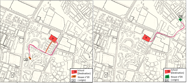
Regarding the second exercise which consists of tracking the itinerary, using the wayfinding task, children were asked to remember their daily itinerary from home to school and to draw it on a given representative map that covers the perimeter of all 30 children’s homes including the school (Figure 4). This data shows that children can distinguish up to two different itineraries between the starting point O (home) to destination D (school) (Figure 5).
When the children were asked about the reason for taking one route instead of another, they said that they were being influenced by adults (parents/teachers) when walking with them or just observing them and by verbal instructions that they may have received previously. Each itinerary is different from the other according to four factors, being: gender, age, topological steps and path length.

In order to compare and confirm the drawn itineraries, a participatory observation was undertaken by walking along with ten children from home to school (Figure 6) and taking notes of their spatial behaviour and indicators of wayfinding they are using.

Cognitive maps were analysed with respect to both genders of children going to/coming back from school by foot. It should also be stated that an equivalent methodology was implemented in the research of Ünlü and Çakir (2002), which comparatively investigates the cognitive maps of primary school children going to school by foot, school bus and other vehicles.
After reading and analysing the cognitive maps in addition to the commentaries and answers added by each child, we were able to identify the spatial relationship of children with their choice of itinerary from home to school as being mainly based on cognitive perception as follows:
During the drawing session, 23 children (76.7%) were referring to their itinerary and the paths they were taking by describing the different topological connections between the city elements they perceive in the environment such as proximity, separation, order, entourage and continuity. Whereas only 7 of them (23.3%) were describing and drawing their maps according to the different points of view of the elements in the city pattern, and no longer consider them as separate elements but in relation to the environment (Figure 7).
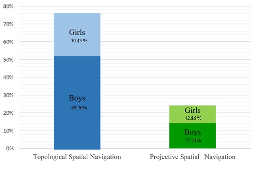
Based on the second exercise (drawing the itinerary) and the participatory observation of their itineraries, we can start identifying the factors that influence children’ patterns of perceptual memorization, which in turn seems to be influenced by the frequency of use and gender. With regard to the latter, boys tend to exercise wayfinding as a goal of exploratory navigation (11 out of 15) while girls navigate to a familiar destination with accuracy (13 out of 15) (Figure 8).
Based on Lynch’s city elements, we studied the cognitive maps in parallel with children’s answers and descriptions of their itineraries. Children have appropriated the basic elements of the urban structure to their ways of perception (Figure 9), which gives them a particular imageability and thus a limited legibility. The cognitive maps created by the children translate the five elements of the city according to the cognitive development stage of the child as follows:


Space syntax is a set of tools for analysis, quantification and description for the analysis of spatial configurations in different forms. The main interest of this syntactic analysis is the study of the relationship between the primary school and the different residential neighbourhoods surrounded within a perimeter of 400 m to identify how these spaces influence the movement.
Isovist analysisIsovist analysis efficiently analyses visibility from a given observation point or set of positions in all directions. To prevent bias from personal route or view choice, Turner, Doxa, et al. (2001) rationally recommend picking a collection of vantage points that most accurately depict the spatial system - referred to as a sufficient set. Although such a sufficient collection may adequately reflect the geographic situation, certain points may be socially useless.
The vantage points chosen in this research are the points where the child decided to make a turn and change direction, in the itinerary n°20, isovists were produced at the origin point “O” and the two points “P1” and “P2” being limited at 180 degrees to assume the visibility of the child. Regarding the second itinerary chosen, n°4, points “O’”, “P1’”, “P2’” and “P3’” were the vantage points used to identify the isovits corresponding to them (Figure 10).
In order to analyse the significance of these isovists, we need to go through the descriptors that characterise them.
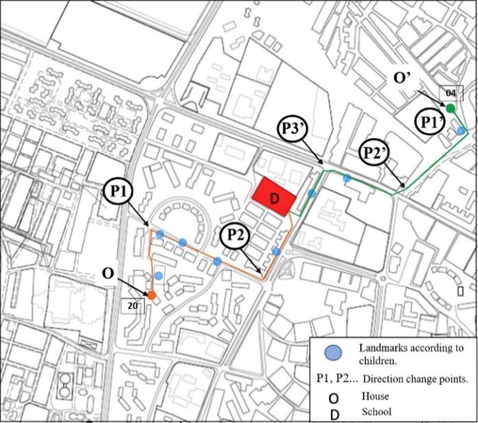

In these two examples the origin points have almost identical Areas (Figure11) (Av of 6124.7 and 6056.8) showing a low number of connectivity, so not many choices to lead to point D. The largest Area (Av: 53076.9) is on a main road, hence it provides a large visibility field. The Perimeter measure shows us that children seek to take the path that leads to a preponderant length of the edge of all space visible from the previous location. The relative value of Compactness identifies the regions of this city pattern in which the child’s spatial experience is contiguously consistent in itinerary n°20, and some regions identify and correlate to meaningful instances (such as their personal landmarks). The lowest value of Drift being the origin point in both itineraries (Dv: 64.93; 145.14) demonstrates being visible from all directions. This value increases while children move toward Point D, and are regions from which space can be surveyed with a minimum of head turning.
Average radial values indicate that the “through vision” varies from point to point across the itinerary and does not impact the decision making in this case. Regarding the Occlusivity, it seems to be relative to the Perimeter values so as when the child gets to a larger edge of visibility field it instantly reveals unseen spaces during the walk to school (Table 2).
| Characteristic | Av | Pv | Cv | Dv | Qv | Ov | |
|---|---|---|---|---|---|---|---|
| Unit | (m²) | (m) | (m) | (m) | m | ||
| Itinerary 20 | O | 6124 | 833 | 0.11 | 64 | 99 | 533 |
| P1 | 25971 | 2155 | 0.07 | 212 | 186 | 1349 | |
| P2 | 42167 | 2978 | 0.06 | 117 | 200 | 1527 | |
| Itinerary 4 | O’ | 6056 | 1021 | 0.07 | 145 | 286 | 617 |
| P1’ | 9780 | 892 | 0.15 | 153 | 133 | 402 | |
| P2’ | 29997 | 4105 | 0.04 | 152 | 525 | 2520 | |
| P3’ | 53076 | 3792 | 0.05 | 472 | 426 | 1855 |
Turner (2001) defined an environment's visibility graph as “a network of mutually visible sites in a spatial configuration”. The authors used visibility graph analysis, or VGA, to get finer spatial differentiation metrics to other syntactic analysis methods. The visibility graph is crucially dependent on the isovist (Turner, Doxa, et al., 2001).
The set of perspective points that are directly visible from a specific vantage point inside a pattern is the first step for generating the visibility graph; this collection of points is basically similar to the isovist.
According to the examples of itineraries used in this VGA, values of visual connectivity increase each time; in itinerary N°20 connectivity values go from 249 in point “O” to 1080 in “P1” to 1671 in “P2”. In itinerary N°4 connectivity values vary from 240 in point “O’” to 385 in “P1’” to 1655 in “P2’”, and 2162 in “P3’” (Figure 12). These results affirm that children walking from home to school or vice versa tend to navigate through space using their sensory and cognitive spatial information and feel safe and confident to take a turn when in a more connected area, to get nearer and nearer to the destination point. Moreover, visibility in a spatial configuration takes the biggest importance for children when deciding themselves on their itinerary choices, because it represents the main, if not the first, source of perceptual information given to the child on whether to build their spatial pattern memorisation when navigating through an unfamiliar environment, or to be used as a reference to compare to and make sure to make the necessary choice while walking to a known destination through a familiar itinerary.

As part of this study, school children aged 6 to 10 years were asked to draw cognitive maps of their journey to school. These maps were analysed on the basis of the parameters of spatial perception and imageability. The resulting data shows a correlation with the results of the syntactic analysis. For this study, such an analysis extended to visibility, sensory perception as well as other syntactic measurements such us “connectivity” for the spatial configurations of this study area. The results of this research indicate that any element of the city, and in particular the landmarks, seem to affect the spatial perceptions of children. They prefer most of the time the landmarks in proximity of their school environment. This is in addition to the social and external influences that can often be the subject of easy and readable navigation.
These results also indicate that there is a difference between children of both genders in the same category of cognitive development. At the stage of concrete operations boys tend to explore more unfamiliar spaces and therefore have a richer and better readable cognitive map than girls. This boys-girls difference seems to be in tune with the results from Ikeda, Mavoa, et al. (2020) who found that active travel has a higher prevalence among older children and particularly boys (46.3%) as opposed to girls (42.6%).
The research presented in this paper, though innovative, has limitations for its findings to be generalised even for the Algerian national context.
The distance travelled by the children from home to school is short (40% of journeys less than 500 m) and may not represent a true picture of school journeys. The size of the sample (30 children) is another factor that needs to be taken into account. For a statistically meaningful set of data, larger samples drawn from a variety of schools with different urban contexts would be required.
This research is interested in the processes involved in children’ decision making process relating to itinerary choices during their home-to-school walking journeys, and the factors likely to affect their cognitive maps in such a process.
This study uses a multi-method approach, including a case study with a sample of 30 school children. The first method being the collection and analysis of cognitive maps of the school journey to reveal children’s attitudes, knowledge, feelings and behaviours towards the environment. The second method was the observation during children’ school-home journey. At last, the data obtained from the cognitive maps was used in a syntactic analysis to produce some ‘Isovists’ using ‘Depthmap’, and VGA maps were generated to analyse the visual connectivity of the street patterns taking in consideration the itineraries taken by children.
This study demonstrated that children locate themselves in space based on environmental signals, and then establish relationships and pathways between these signals. Spatial representation in a child's cognition is a reflection of the behaviour of the environment as symbolic and internalized cognitive information. The main findings of this study are as follows:
Conceptualization, methodology, original draft preparation, review and editing, R.B.F and H.B, software and field investigation R.B.F, supervision, H.B. All authors have read and agreed to the published version of the manuscript.
The authors declare that they have no conflicts of interest regarding the publication of the paper.