-
Focus on the relationship of international division of labor of Japan-Korea and Japan-China
Kenta YAMAMOTO
Session ID: 413
Published: 2009
Released on J-STAGE: June 22, 2009
CONFERENCE PROCEEDINGS
FREE ACCESS
-
Two Year Contact Analysis by Semi-Real-Time Regular Investigation Method
SHINJI HARA
Session ID: 414
Published: 2009
Released on J-STAGE: June 22, 2009
CONFERENCE PROCEEDINGS
FREE ACCESS
-
A Case Study of 'Ogimachi Creative Cluster'
Satoshi FURUKAWA
Session ID: 415
Published: 2009
Released on J-STAGE: June 22, 2009
CONFERENCE PROCEEDINGS
FREE ACCESS
-
Hiroyuki HAMADA
Session ID: 416
Published: 2009
Released on J-STAGE: June 22, 2009
CONFERENCE PROCEEDINGS
FREE ACCESS
-
Rolf D. SCHLUZNE
Session ID: 417
Published: 2009
Released on J-STAGE: June 22, 2009
CONFERENCE PROCEEDINGS
FREE ACCESS
Jones(2002)critiqued Sassen for producing the simplistic image that corporate power and control is located in MNEs headquarters. From his perspective control is spreading through a decentralized network of social actors across transnational firm networks. However, geographers do not much know about the work and life of those actors. Not only labor, as mentioned by Peck, but also putting executive managers into its place is intrinsically geographic, especially when expatriated abroad. The analytical approach introduced here is an actor-centered approach using quantitative analysis on individual and managerial performance. Based on the described model of the interrelationship of managerial behavior, activity space and location decision making, a questionnaire survey was build. It was send to foreign executive managers of foreign firms listed in the German Chamber of Commerce member directory. The questionnaire was answered by 81 executive managers, a reply rate of 57. Discriminant analyses were applied to distinguish the important elements of a) foreign executive managers' individual performance and b) different business environments. I distinguished a) between Expatriate and Hybrid managers; and b)between two business environments affected differently by globalization. To measure difference between 1) normal Expat-manager and Hybrid-manager; and 2) Tokyo-Yokohama and Osaka-Kobe discriminant analyses were conducted with predictors giving information about managerial behavior.
1) Distinguishing Characteristics of Manager Types
The discriminant analysis showed that 1) language proficiency, 2) a supportive Japanese partner and 3) involvement in decision processes were most important in distinguishing between Hybrid and Expatriate managers. Although, they showed modesty with their self-assessment, it became obvious that language is very important management element when doing business in Japan. Second, in the acculturation process the support of a Japanese partner is important since instant feedback can only be expected from a very close person within Japanese culture. Third, the manager can be distinguished from the normal expatriate manager by frequent involvement in the decision making process.
2) Distinguishing Characteristics of Regions
The discriminant analysis showed that 1) corporate growth aims 2) experiences and 3) corporate decisions were most important in distinguishing between Tokyo-Yokohama and Osaka-Kobe.In Osaka-Kobe the Hybrid manager takes the lead: his acculturation process is advanced. Therefore, cultural experiences are paramount and he can look back on a longer stay than his counterpart in Tokyo-Yohohama. Decisions with a focus on success in the local market vary by location. In Osaka-Kobe the foreign manager promotes decisions for expansion, products, service and market creation. In Tokyo-Yokohama normal manager is likely to propose growth aims targeting the local market.
We assume that the hybrid manager's cultural knowledge and sensitivity towards local customs and values achieved by language proficiency and through a supportive partner in private life, and the strong will to get involved in the decision making of the local subsidiary, leads to a better performance in the intercultural workplace. The empowerment of the Hybrid-manager derives more from his local workplace performance and less from headquarters relations. To conclude, the analysis of the questionnaire showed that foremost acculturation is vital for distinguishing the Hybrid manager from the normal Expat-manager. The results led us assume that strategic intent differs by location. We can assume that the strategic intent of the foreign executive manager based in the first tier global city correlates with globalizing efforts. On the other hand, the strategic intent of a manager based in a second tier global city, such as Osaka-Kobe, is characterized by localizing activities.
View full abstract
-
A Social Network Analysis of the Shima Kosaku Business Manga
Michael Plattner
Session ID: 418
Published: 2009
Released on J-STAGE: June 22, 2009
CONFERENCE PROCEEDINGS
FREE ACCESS
Work in multinational corporations is increasingly located in differing cultural environments. Business networks have changed from being dominated by expatriate managers to ones in which local staff and new intermediary hybrid managers interface in flexible relationships. The key question is the extent to which hybrid managers function as translators of knowledge while contributing to the reduction of transaction cost. To answer that question, a social network analysis was applied to measure homophily, the similarity among related network actors with divergent cultural norms. The structural change of a business network was tested during three periods between 1983 and 2005. The analysis uses the illustrated novel of the reality based Kosaku Shima business manga to review a 267 node network. Findings include that hybrid managers break down barriers of cultural distance. They have become brokers of knowledge between local and global levels of business thereby reducing transaction costs.
View full abstract
-
Yuuzi TATUOKA
Session ID: 419
Published: 2009
Released on J-STAGE: June 22, 2009
CONFERENCE PROCEEDINGS
FREE ACCESS
-
Hideaki WATANABE
Session ID: 420
Published: 2009
Released on J-STAGE: June 22, 2009
CONFERENCE PROCEEDINGS
FREE ACCESS
The Edo era regional market system of Musashi Province was composed of many periodic markets. Previous research includes detailed investigations of some of these periodic markets. However, some periodic markets in this region, such as Tokorozawa Town have not received adequate attention. And in spite of its economic significance, there are few extant records about this periodic market.
The official dedication ceremony, written and presented in 1639 provides the earliest record of a periodic market in Tokorozawa Town in the Edo era. There is, however, little information about the periodic market in the records that we have access to. The earliest record of an original market day in the Tokorozawa periodic market was the regional geography of Kawagoe Domain, which was written in 1702.
In the late eighteenth century, Tokorozawa Town had six town blocks, and each block had its own market day, this suggests that Tokorozawa was a big town in the mid-eighteenth century. The principal goods of the Tokorozawa periodic markets in this period were dried fish, secondhand clothes and other secondhand articles. Traders bought these goods to Kawagoe Castle Town and sold them in Tokorozawa.
The area served by the Tokorozawa periodic markets was large, particularly the Musashino Plateau to the south. Because of low water levels in Musashino, people could not cultivate rice. Therefore they depended on market towns to buy rice and other daily goods. And since a big town never emerged in this low population region, the people from Musashino had to go to market towns as far away as 10km or more. Thus the Tokorozawa market town was particularly important for the people of the Musashino Plateau.
As the town grew, an increasing number of lawless individuals began to assemble within the Tokorozawa market town. For example, in the middle of nineteenth century, gamblers assembled there every market day, even though gambling was illegal. As a result, the village unions around Tokorozawa and Musashino asked the local government to crack down on these gamblers in 1845. The author contends that this indicates that the periodic markets of Tokorozawa were becoming increasingly crowded.
View full abstract
-
YOJIRO UTSUNOMIYA
Session ID: 421
Published: 2009
Released on J-STAGE: June 22, 2009
CONFERENCE PROCEEDINGS
FREE ACCESS
A terrestrial globe once owned by a curate of Myogenji Buddhist temple and now kept by Hagi City Museum
Utsunomiya Yojiro *
This paper describes the form and size of a terrestrial globe once owned by a curate of Myogenji Buddhist temple and now kept in the Hagi City Museum, together with some geographical information it provides. The globe described is 305 mm in diameter and constructed from glued Gofun whitewash. It has a wooden stand with two wooden supports 162 mm in height whose tops are cut to form a crescent-like groove. The axis of the globe is laid horizontally on these grooves, resembling a unicycle. Hence, it can be considered an example of a unicycle-type globe. The stand also serves as the lid of the wooden case, bearing scales measuring 349x349x343 mm. The gores pasted on the face of the globe were produced by redrawing the geographical information on the world map made by Hashimoto Sokichi known as Oranda-shinyaku-chikyuzenzu, which was printed in 1796 and distributed in and around Osaka in the Naniwa area of Kansai, western Japan. Several globes of the same unicycle type are preserved in several museums, including Shimonoseki City Art Museum and Kobe City Museum, in western Japan. Although the name of the globe-maker remains unknown, this globe does not appear to have been produced by an intellectual, or someone with geographical knowledge, as the lines of longitude and latitude are sometimes geminated, and meridian lines drawn at irregular intervals are evident. The maker appears to have been unaware of the significance of these lines, which indicate absolute location on the map. The globe and several newspaper cuttings dated May 10th or 11th 1937 are boxed in a chest. This globe appears to have been made during the period between 1796, when the map on which the gores were based was published, and 1937, which was when the newspaper was printed.
*)Emeritus professor of Mie University.
View full abstract
-
Katsushi SHIMIZU
Session ID: 422
Published: 2009
Released on J-STAGE: June 22, 2009
CONFERENCE PROCEEDINGS
FREE ACCESS
-
Daiju KOSEKI
Session ID: 423
Published: 2009
Released on J-STAGE: June 22, 2009
CONFERENCE PROCEEDINGS
FREE ACCESS
-
Akihiro Yamashita
Session ID: 424
Published: 2009
Released on J-STAGE: June 22, 2009
CONFERENCE PROCEEDINGS
FREE ACCESS
-
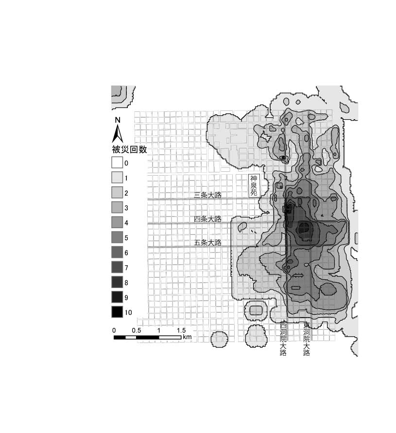
GIS Analysis of Historical Urban Space Structure
AKIHIRO TSUKAMOTO, NAOMI AKAISHI, YASUTAKA WATANABE, KENTA ASADA, SHUT ...
Session ID: 425
Published: 2009
Released on J-STAGE: June 22, 2009
CONFERENCE PROCEEDINGS
FREE ACCESS
-
Akio Muranaka, Tomoki Nakaya
Session ID: 426
Published: 2009
Released on J-STAGE: June 22, 2009
CONFERENCE PROCEEDINGS
FREE ACCESS
-
in case of the lower reaches of the Heihe river, China
Hidehiro SOHMA, Ran TIAN, Jien WEI, Toshio ITO, Kazuki MORIYA, Shinobu ...
Session ID: 427
Published: 2009
Released on J-STAGE: June 22, 2009
CONFERENCE PROCEEDINGS
FREE ACCESS
Previously unrecognized two ruins are recognized in the lower reaches of the Heihe River, China, based on the interpretation from the high-resolution satellite image, the QuickBird Image, and their significance was discussed.
One is the Bj2008 ruins situated at about 8 km northeast direction from the Green City ruins, having nearly a square in plane shape and from 120cm to 140cm each side. This size is nearly the same as the ruins of K710 and K688, both considered to belonging in the Former Han dynasty. Fragments of earthenware scattered around the Bj2008 ruins are mainly of the former Han dynasty and a small number of the Xixa and Yuen dynasty. These suggest the Bj2008 ruins are of the Former Han dynasty.
The Bj2008 ruins also situated nearly on the line from the A1 ruins to the Thirtieth well ruins and about 25 km from the latter. Above mentioned suggests the Bj2008 ruins have constructed as one of the essential wall-surrounded city on the area planning of the lowerer reaches of the Heihe River in the Form Han dynasty.
Direction of the diagonal line from the northwestern corner to the southeastern of the Bj2008 ruins roughly apparel to those of the strong winds formed the yardan topography surrounding them. This fact suggests the direction of the strong winds was also considered for making the wall-surrounded city.
Land patterns like the Honeycomb also interpreted from the QuickBird Image. The patterns are resemble to the outian system , a kind of farming techniques for saving water used in China, especially promoted in arid and semi-arid region in Yuen Dynasty.
This land patterns situated about 1 km to south direction from the Green City ruins and the cast of a small canal flowing here from the fragments of two house remnant of the Xixa. Some parts of the surface undulation are reverse to the outian system of the text and the diameter of the relatively higher part, 1m to 5m, is also larger than the text. So, these land patterns are named the pseudo-outian system. Anyway, this is the first time that the land patterns of the outian system or the pseudo-outian system actually recognized at the fields.
My presentation will give the information on new ruins discovered from the high-resolution satellite images and their significance, in case of the lower reaches of the Heihe River, China
data for reconstruction of the water usage in the ancient times in the arid regions of China.
I graduated doctoral course in geography of Tokyo University and my major field is physical geography. I have interested in the terrestrial conditions of ruins along the Silk-Route of the oases route in the Central Asia and China, and visited many ruins such as the Lou-lan, Miran, Kara-hoto etc. Interpretation of air-photographs and the high resolution satellite images and fields survey are my main methods.

View full abstract
-
SooKyung Park
Session ID: 501
Published: 2009
Released on J-STAGE: June 22, 2009
CONFERENCE PROCEEDINGS
FREE ACCESS
-
NOBUYUKI IWAMA, KOICHI TANAKA, MIDORI SASAKI, NOBUHIKO KOMAKI, YUKIO S ...
Session ID: 502
Published: 2009
Released on J-STAGE: June 22, 2009
CONFERENCE PROCEEDINGS
FREE ACCESS
-
Takayuki OGATA
Session ID: 503
Published: 2009
Released on J-STAGE: June 22, 2009
CONFERENCE PROCEEDINGS
FREE ACCESS
This study listed 164 Japanese gardens situated in the Kyoto basin, consisting mainly of the Kamogawa alluvial fan and the Katsuragawa flood plain. The listed gardens were mapped with Geographic Information System (GIS). During the Edo era, civil engineering improvements promoted construction of large scale gardens. Gardens without surface water are mainly distributed in the center of the Kamogawa alluvial fan with relatively deep groundwater. Gardens with surface water, in contrast, are concentrated along the foot of the Higashiyama hills where hydrological recharge zones produce rich springs. During the Taisho era, Biwako-sosui (canals from the Biwa Lake to the Kyoto basin) contributed to construction of gardens with surface water, such as artificial ponds, flows and falls. Both physically and artificially, hydrological conditions controlled the geographic distribution of Japanese gardens.
View full abstract
-
in a heavy snow region of central Japan: from the perspective of the climatic landscape
Emiko NAKAYAMA
Session ID: 504
Published: 2009
Released on J-STAGE: June 22, 2009
CONFERENCE PROCEEDINGS
FREE ACCESS
This paper examined the utilization of a unique snow melting system for clarifying the human adaptation to the heavy snow in the mountainous region of Iiyama city, Nagano Prefecture of the central Japan. The author simultaneously applied the participatory research and the life history of the two aged inhabitants. The average snow depth of this region is 200-300m with a maximum depth of 438m in 2006. The residents call this melting system "tane". People build up the water channel and throw the snow into the running water of the channel. Some of the residents build "fuyu-tane" which means the winter ponds for melting snow. Every year, they dig the ponds for melting the snow, especially snowdrops from the roof at the same location of their homestead. They bury the ponds when the spring comes. They also regard the importance for raking snow away from the surrounding of the house entrance. They utilize the tane and fuyu-tane for early snow melting and this activity prevents from damaging the house and enables them to start the rice-planting at their paddy field. The distribution of tane and fuyu-tane is predominant at the mountains of Sekita with the streams of the abundant water. Based on the life history of the residents, they acquire the ecological knowledge, cognizance and hard-job virtue for the adaptation to the severe winter. The maintenance of tane and fuyu-tane indicate the symbol and identity of the residents for their decision to survive the severe winter and heavy snow environment.
View full abstract
-
Kunihito Kudoh, Masanori Sugimura
Session ID: 505
Published: 2009
Released on J-STAGE: June 22, 2009
CONFERENCE PROCEEDINGS
FREE ACCESS
Shimabata is one of the agricultural style and landscape in Japan.
Shima means 'island' and
bata does 'dry field'. That's shape is two storied, with paddies occupying the lower floor and unirrigated crops the thousands of elevated patches which rise like small buttes, two to four feet high, above the lower inundated fields(Trewartha 1928). Thus, those patches look like islands on paddy field. The remarkable feature of
shimabata is to have elements of both paddy and dry fields. Kunio Yanagita said that Japanese agriculture had established by rice-producing. On the other hand, Hirofumi Tsuboi said that had done by farming in non-paddy fields. However
shimabata does not fall under both theories.
Shimabata was distributed in many places in Japan, at least forty years ago. That fact was cleared by J. Takeuchi(1967). But there are few sites where
shimabata exists.
Shimabata is formed at natural levee or edge of alluvial fan, for example. Those sites have handicap by water supply. People dug down land and make lower place paddy field. And then they make upper patches dry fields (=
shimabata). That is wisdom for Japanese agriculture. However irrigation technology has developed, people need not dig down land for water supply. In addition, patch distribution of
shimabata disturbs mechanization for agriculture. It is a profitable to put farm planning into effect in terms of agricultural production. Mitsui is a rare case and has a value to clear why
shimabata has remained in that area. That area belongs to urbanization control area. So there is the restrict on changing to other land-use. In addition, farmers in that area have a small agricultural land and it is difficult to integrate their issues for future planning. It is different from the case that some places of rice terraces change for or/and are added tourist attractions.
Shimabata also has ecological diversity because of farmers use few agricultural chemicals. They produce crops for themselves mainly, so they do or need not use. Various creatures can live there.
Shimabata has not only historical value but also another one. However
shimabata in Mitsui is on the verge of the extinction. It is also important that we record
shimabata.
View full abstract
-
Case Study of Kita-Harima, Hyogo Prefecture
HIDENORI OKAHASHI
Session ID: 506
Published: 2009
Released on J-STAGE: June 22, 2009
CONFERENCE PROCEEDINGS
FREE ACCESS
-
A case study of grazing association and group farming
Tatsuya Kanda
Session ID: 507
Published: 2009
Released on J-STAGE: June 22, 2009
CONFERENCE PROCEEDINGS
FREE ACCESS
-
Tadanao MATSUO
Session ID: 508
Published: 2009
Released on J-STAGE: June 22, 2009
CONFERENCE PROCEEDINGS
FREE ACCESS
-
Madoka UEMURA
Session ID: 509
Published: 2009
Released on J-STAGE: June 22, 2009
CONFERENCE PROCEEDINGS
FREE ACCESS
-
:Pay attention to the business of the grant-aided soybean for the fermented soybeans maker:
Amane KAMEDA
Session ID: 510
Published: 2009
Released on J-STAGE: June 22, 2009
CONFERENCE PROCEEDINGS
FREE ACCESS
-
A case study of Higashi-Hagima district, Makinohara City, Shizuoka prefecture
Takayuki OISHI
Session ID: 511
Published: 2009
Released on J-STAGE: June 22, 2009
CONFERENCE PROCEEDINGS
FREE ACCESS
-
Ena KONNO
Session ID: 512
Published: 2009
Released on J-STAGE: June 22, 2009
CONFERENCE PROCEEDINGS
FREE ACCESS
-
A Case Study of Geisei Village, Kochi Prefecture
TAKAHIRO ITO
Session ID: 513
Published: 2009
Released on J-STAGE: June 22, 2009
CONFERENCE PROCEEDINGS
FREE ACCESS
-
Nakarie, Kitsuki-shi, Oita Prefecture, Japan
Takehisa Sukeshige
Session ID: 514
Published: 2009
Released on J-STAGE: June 22, 2009
CONFERENCE PROCEEDINGS
FREE ACCESS
-
Geographical studies on the commodification of Japanese rural spaces, Part 5
Tadayuki MIYACHI
Session ID: 515
Published: 2009
Released on J-STAGE: June 22, 2009
CONFERENCE PROCEEDINGS
FREE ACCESS
-
Geographical Studies on the Commodification of Japanese Rural Spaces, Part 6
Nagatada TAKAYANAGI, ENA KONNO, Hideyuki OGAWA, Takashi ISONO
Session ID: 516
Published: 2009
Released on J-STAGE: June 22, 2009
CONFERENCE PROCEEDINGS
FREE ACCESS
-
Geographical studies on the commodification of Japanese rural spaces, Part 7
Masaaki Kureha
Session ID: 517
Published: 2009
Released on J-STAGE: June 22, 2009
CONFERENCE PROCEEDINGS
FREE ACCESS
-
:Geographical studies on the commodification of Japanese rural spaces, Part 8
Go FUJINAGA
Session ID: 518
Published: 2009
Released on J-STAGE: June 22, 2009
CONFERENCE PROCEEDINGS
FREE ACCESS
-
A comparison with cases of full service carriers
Koichi Tanaka
Session ID: 519
Published: 2009
Released on J-STAGE: June 22, 2009
CONFERENCE PROCEEDINGS
FREE ACCESS
-
SACHIKO ENDO
Session ID: 520
Published: 2009
Released on J-STAGE: June 22, 2009
CONFERENCE PROCEEDINGS
FREE ACCESS
-
HIROKI YAMASHITA, SATORU ITOH
Session ID: 521
Published: 2009
Released on J-STAGE: June 22, 2009
CONFERENCE PROCEEDINGS
FREE ACCESS
-
Jun YAMASHITA
Session ID: 522
Published: 2009
Released on J-STAGE: June 22, 2009
CONFERENCE PROCEEDINGS
FREE ACCESS
-
Taketo KOBAYASHI
Session ID: 523
Published: 2009
Released on J-STAGE: June 22, 2009
CONFERENCE PROCEEDINGS
FREE ACCESS
-
Analysis of questionnaires to new adoted teachers
YOMIKO TAKIZAWA, HIROAKI AKIMOTO, KOJI ISHIZUKA, KAORU HIRASAWA, YOUIC ...
Session ID: 524
Published: 2009
Released on J-STAGE: June 22, 2009
CONFERENCE PROCEEDINGS
FREE ACCESS
-
yuuichi henmi
Session ID: 525
Published: 2009
Released on J-STAGE: June 22, 2009
CONFERENCE PROCEEDINGS
FREE ACCESS
-
Taro Futamura
Session ID: 526
Published: 2009
Released on J-STAGE: June 22, 2009
CONFERENCE PROCEEDINGS
FREE ACCESS
-
Michio Nogami
Session ID: 601
Published: 2009
Released on J-STAGE: June 22, 2009
CONFERENCE PROCEEDINGS
FREE ACCESS
-
Yasushi TANAKA
Session ID: 602
Published: 2009
Released on J-STAGE: June 22, 2009
CONFERENCE PROCEEDINGS
FREE ACCESS
-
Hidetsugu Yoshida, Toshihiko Sugai
Session ID: 603
Published: 2009
Released on J-STAGE: June 22, 2009
CONFERENCE PROCEEDINGS
FREE ACCESS
-
HIROMU DAIMARU, WATARU MURAKAMI
Session ID: 604
Published: 2009
Released on J-STAGE: June 22, 2009
CONFERENCE PROCEEDINGS
FREE ACCESS
-
Hiroshi P. SATO, Takayuki NAKANO, Hiroshi UNE
Session ID: 605
Published: 2009
Released on J-STAGE: June 22, 2009
CONFERENCE PROCEEDINGS
FREE ACCESS
Noto Hanto earthquake (M-6.9) occurred at the depth of 10 km, off shore of West Noto peninsula on 25 March 2007. The previous study detected horseshoe-shaped surface deformation at Furue, Nakajima Town in Nanao City, Ishikawa Prefecture using synthetic aperture radar (SAR) interfeferograms. It indicated the possibility that the deformation initially occurred regardless of crustal deformation and existing landslide landform, mapped by Disaster Prevention Research Institute. In this study we described micro landform on the topographic map, surveyed by airborne Light Detection and Ranging (LiDAR) and investigated the relation between the surface deformation and the micro landform. As a result, existing landslide was identified at the southwest part of the deformation; however, its scar orientation is not coincident with the direction of motion by the deformation. Furthermore, we could not existing landslide landforms with in the deformation. Therefore, we again revealed that the deformation initially occurred as the landslide motion. To reveal its cause of the motion, further investigations are needed to reveal 3-D distribution of weathering layer thickness, acquifer, and tuff within the geologic unit where deformation is located. In the future it is desirable to investigate them using boring and geophysical exploration.
View full abstract
-
Mamoru Koarai, Kazuo Amano
Session ID: 606
Published: 2009
Released on J-STAGE: June 22, 2009
CONFERENCE PROCEEDINGS
FREE ACCESS
-
Kyoko Kagohara, Hideki Kurosawa, Hideki Kosaka, Tsuneari Ishimaru
Session ID: 607
Published: 2009
Released on J-STAGE: June 22, 2009
CONFERENCE PROCEEDINGS
FREE ACCESS
-
Yugo NAKAMURA, Yuichi NISHIMURA, Mitsuhiro NAKAGAWA, Viktor M. KAISTRE ...
Session ID: 608
Published: 2009
Released on J-STAGE: June 22, 2009
CONFERENCE PROCEEDINGS
FREE ACCESS
Five Holocene marker tephras from Hokkaido Island, i.e. Tarumae-a tephra (Ta-a, AD1739), Komagatake-c2 tephra (Ko-c2, AD1694), Mashu-b tephra (Ma-b, 774-976 cal BP), Tarumae-c tephra (Ta-c, 2500-2800 cal BP), and Mashu-d1 tephra (Ma-d1, 3267-3368 cal BP) are identified in the sedimentary sequences of coastal lowlands on Kunashiri and Shikotan Islands, southern Kuril Islands, on the basis of the refractive index and major element analyses of tephra glass shards. Ko-c2 and Ta-c are the most distinguishable ash fall deposits, providing valuable time markers to examine Holocene issues such as paleotsunamis.
In addition, more than 12 tephra layers are described and presumed to be the products of volcanoes in Kunashiri Island. Many of them contain glass shards showing relatively low refractive index (n=1.480-1.490) and high SiO2 content (77-79%) in comparison with the widespread tephras from Hokkaido Island. These tephras are classified into seven types according to TiO2-K2O contents. They are presumably supplied from three or more volcanoes in Kunashiri Island.
View full abstract
-
Reisuke KONDO, Takeyuki UEKI, Sumiko TSUKAMOTO
Session ID: 609
Published: 2009
Released on J-STAGE: June 22, 2009
CONFERENCE PROCEEDINGS
FREE ACCESS