-
-Geology, Geomorphology, and seasonal change of groundwater level and water temperature-
KUNIHIDE MIYAOKA, HYE-SOOK PARK
Session ID: P1013
Published: 2009
Released on J-STAGE: June 22, 2009
CONFERENCE PROCEEDINGS
FREE ACCESS
-
Hidekazu SUZUKI, Ken HARAGUCHI, Norio TASE, Yoshine UCHIDA
Session ID: P1014
Published: 2009
Released on J-STAGE: June 22, 2009
CONFERENCE PROCEEDINGS
FREE ACCESS
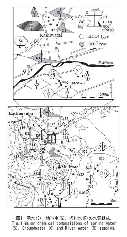
The purpose of this study is to understand the origin and geochemical process of a flowing confined groundwater (G1) in the Higashi-Hachimantai area, Iwate Prefecture Northeast Japan which is located on the northern foot of Mt. Iwate and the southeastern margin of Hachimantai volcanic groups. Spring, ground and river water samples were collected in and around study area, and major dissolved ions and stable isotopes of O, H and S of these samples were measured.
Major chemical compositions of the water samples were divided into two types on the boundary of Matsu River through the central part of study area. One is a Ca-HCO
3 (Iwate) type water in Kanazawa district at the south part of the river and another is a Ca-SO
4 (Hachimantai) type water in Kashiwadai district at the north part which located on the flowing well (Fig.1). Though chemical composition of G1 is Ca-SO
4type it also contains relatively high concentrations of bicarbonate and chloride. On the basis of these chemical properties, it is assumed that G1 was formed by mixing of Ca-HCO
3 type and Ca-SO
4 type groundwaters. In order to estimate the mixing ratio of two types groundwater in G1 we calculated how the chemical compositions varied when G3 (Iwate type) and S2 (Hachimantai type) were mixed at the various rate. As a result of the calculation, the chemical composition of mixed water was similar to that of G1 when the ratio of G3 to S2 is 3:2.
The groundwater samples of Iwate and Hchimantai types are also different from each other in the d-excess value, which ranges from 14.6 to 16.4 in the former and from 17.7 to 21.0 in the latter. This means that the water samples of Kashiwadai district are recharged on the Hachimantai volcanic groups and those of Kanazawa district are recharged on the Mt. Iwate, because the d-excess of meteoric water in the Northeast Japan has higher value in the Japan Sea (west) side and it gradually declines toward the Pacific Ocean (east) side. Because the d-excess of G1 was 16.8 which is an intermediate value of both Iwate and Hachimantai types, it was estimated that G1 is formed by the mixing of groundwater of Iwate and Hachimantai types at the almost equal rate.
The sulfur isotope composition of dissolved sulfate in Iwate type groundwater was different from that in Hachimantai type one as well as major chemical composition and d-excess. The sulfur isotope compositions of two water samples in Iwate type were higher values of +10.0 and +12.3 per mil, while those of two water samples in Hachimantai type were lower values of -2.6 and -6.2 per mil. As the sulfur isotope composition of G1 is -1.6 per mil, the mixing ratio of groundwater of Iwate and Hachimantai types estimated by the sulfur isotope seems to be larger contribution of Hachimantai type groundwater than Iwate type one compared with the mixing ratio estimated by the major chemical composition and the d-excess.
As a result of above discussions, it is concluded that the flowing confined groundwater (G1) in the Kashiwadai district located on the north part of study area is mixed groundwater of Hachimantai type with that of Iwate type which flows from the Mt. Iwate into Kashiwadai district, passing through under the Matsu River.
View full abstract
-
Hirohito NISHIZAKI, Koji KODERA
Session ID: P1015
Published: 2009
Released on J-STAGE: June 22, 2009
CONFERENCE PROCEEDINGS
FREE ACCESS
-
Imelida Genson, Yoshiko Iizumi
Session ID: P1016
Published: 2009
Released on J-STAGE: June 22, 2009
CONFERENCE PROCEEDINGS
FREE ACCESS
-
Yoshiko Iizumi, Atsuko Terazono, Imelida Genson, Toru Shimoda
Session ID: P1017
Published: 2009
Released on J-STAGE: June 22, 2009
CONFERENCE PROCEEDINGS
FREE ACCESS
-
A case of Kitakami river
Tomoyuki HIRAYAMA, Koji KODERA, Toshiki TSUZUKI
Session ID: P1018
Published: 2009
Released on J-STAGE: June 22, 2009
CONFERENCE PROCEEDINGS
FREE ACCESS
-
Shigeyuki OGAWA
Session ID: P1019
Published: 2009
Released on J-STAGE: June 22, 2009
CONFERENCE PROCEEDINGS
FREE ACCESS
-
Mamoru Koarai, Takayuki Nakano, Junko Iwahashi, Yoko Hirose
Session ID: P1020
Published: 2009
Released on J-STAGE: June 22, 2009
CONFERENCE PROCEEDINGS
FREE ACCESS
-
Nobuo SAKAGAMI, Makiko WATANABE
Session ID: P1021
Published: 2009
Released on J-STAGE: June 22, 2009
CONFERENCE PROCEEDINGS
FREE ACCESS
-
Natsuko Uoi, Makiko Watanabe, Nobuo Sakagami, Tomoyoshi Murata
Session ID: P1022
Published: 2009
Released on J-STAGE: June 22, 2009
CONFERENCE PROCEEDINGS
FREE ACCESS
-
Hisamitsu MIYAUCHI
Session ID: P1023
Published: 2009
Released on J-STAGE: June 22, 2009
CONFERENCE PROCEEDINGS
FREE ACCESS
-
Kenichiro HATANAKA
Session ID: P1024
Published: 2009
Released on J-STAGE: June 22, 2009
CONFERENCE PROCEEDINGS
FREE ACCESS
-
Yoshio TAGAMI
Session ID: P1025
Published: 2009
Released on J-STAGE: June 22, 2009
CONFERENCE PROCEEDINGS
FREE ACCESS
-
Shigeo SUZUKI
Session ID: P1026
Published: 2009
Released on J-STAGE: June 22, 2009
CONFERENCE PROCEEDINGS
FREE ACCESS
-
Temperature environment of winter camp and summer camp
Yuki Morinaga, Takahiro Ozaki, Kaoru Kakinuma, Seiki Takatsuki, J Chul ...
Session ID: P1027
Published: 2009
Released on J-STAGE: June 22, 2009
CONFERENCE PROCEEDINGS
FREE ACCESS
-
Yuichi KAGAWA, Kenta SAKATA
Session ID: P1028
Published: 2009
Released on J-STAGE: June 22, 2009
CONFERENCE PROCEEDINGS
FREE ACCESS
1. Preface
Illegal dumping waste becomes the problem. There are many wastes as for the illegal dumping in the river, we compare it with industrial waste and are hard to identify a person of disposal, and the regulation is difficult. Therefore, in the self-governing body of the coast and the community of the coastal area, administration, local inhabitants, the police cooperate and, for the issue of illegal dumping to the river, try for prevention of the illegal dumping. But there is no end to illegal dumping under the present conditions.
2. An investigation method
The data collection method of the illegal dumping waste assumes the field work that I used the GPS receiver in the object river for basics. We referred to collection / data and an existing study about the illegal dumping, a classification method of the garbage of the Inukami abandonment area self-governing body that we arranged and set the candidate of the factor to be concerned with the illegal dumping place to use for analysis, a classification standard of the illegal dumping waste.
We make the illegal dumping map which used Google Earth and ArcGIS based on these position data. From this illegal dumping map, we analyzed an outbreak factor of geographical illegal dumping waste according to a kind of the garbage. We did the object range with sections from the Inukami river river mouth to the irrigation of Kanaya equal to the fan top share of the alluvial fan and did position / kind / the outskirts situation of the illegal dumping waste with an investigation item.
3. A result / consideration
We confirmed 1,270 points of samples that it seemed that we were related to illegal dumping. 88 points are signboard, illegal dumping preventive measures quality of the surveillance camera among 1,270 points of samples. In addition, the illegal dumping point that we confirmed is 1106 spots. Most of the illegal dumping waste which we confirmed in a field work were scattering-related garbage. Though a signboard and the fence of the anti-illegal dumping measure are installed in the scattering-related garbage, it is often that it is abandoned illegally. In addition, we were able to confirm the section where illegal dumping was concentrated.
Even if a drink container lasted in a whole terms of reference, it was abandoned a lot illegally. It seems that the most were abandoned by a passerby. In addition, the illegal dumping was easy to occur from a bridge so as to be near and is hard to have come to occur so as to leave it. However, we objected with these, and we hardened, and, as for the slightly bigger illegal dumping waste such as a household appliance, a bicycle, the tire, the bottoms of the bridge were dumped in the specific place illegally.
We can choose the neighborhood of bridge as an illegal dumping outbreak factor when we consider a geographical outbreak factor of the illegal dumping in the river from an illegal dumping map. It is the present conditions that most illegal dumping measures do not do a meaning so that it is almost scattering of the illegal dumping to be able to put in the vicinity of a bridge-related garbage, and it tends to be dumped illegally though illegal dumping measures are put about the scattering-related garbage. On the contrary, we can choose the neighborhood of public accommodation as a prevention of illegal dumping factor. In the range where public accommodation was next to, there was comparatively little number of illegal dumping waste. The illegal dumping avoids the public eye, and it is performed, but the public accommodation is a resort, and it is thought that the neighborhood of public accommodation has little illegal dumping. In addition, we can choose the anti-illegal dumping measure thing as a prevention of illegal dumping factor, but though illegal dumping measures are put about the scattering characteristics garbage such as drink relations or food relations, it is dumped illegally, and future measures are expected.
View full abstract
-
Kensuke GOTO, Takahito KUROKI, Keisuke KURODA, Tatsuro SOH, Nozomi ISO
Session ID: P1029
Published: 2009
Released on J-STAGE: June 22, 2009
CONFERENCE PROCEEDINGS
FREE ACCESS
-
Takahito KUROKI, Nozomi ISO, Kensuke GOTO
Session ID: P1030
Published: 2009
Released on J-STAGE: June 22, 2009
CONFERENCE PROCEEDINGS
FREE ACCESS
-
Shuichi ITO
Session ID: P1031
Published: 2009
Released on J-STAGE: June 22, 2009
CONFERENCE PROCEEDINGS
FREE ACCESS
-
focused on foreigner residences
Takashi KIRIMURA
Session ID: P1032
Published: 2009
Released on J-STAGE: June 22, 2009
CONFERENCE PROCEEDINGS
FREE ACCESS
-
SongJun Dai, Hiroji FUJISHIMA
Session ID: P1033
Published: 2009
Released on J-STAGE: June 22, 2009
CONFERENCE PROCEEDINGS
FREE ACCESS
-
International Managers' Practices and their Locational Preferences
Rolf D. Schlunze, Michael Plattner
Session ID: P1034
Published: 2009
Released on J-STAGE: June 22, 2009
CONFERENCE PROCEEDINGS
FREE ACCESS
Relocation and concentration of globally linked business operations is closely connected to the lifestyles of foreign executive managers. This study analyzes foreign executive managers' lifestyles and locational preferences. The approach developed distinguishes types of executive managers by evaluating their potential for creating cultural synergy. This study applies conjoint analysis to quantify executive locational preferences. The study led to interviews of 47percents of the study population, 58 individuals. The analysis shows significant differences in the lifestyles of international managers. Executives' preferences regarding first and second tier locations show significant correlation with their creation of synergies.
View full abstract
-
genichi Terasawa
Session ID: S101
Published: 2009
Released on J-STAGE: June 22, 2009
CONFERENCE PROCEEDINGS
FREE ACCESS
-
Tomotaka ITO
Session ID: S102
Published: 2009
Released on J-STAGE: June 22, 2009
CONFERENCE PROCEEDINGS
FREE ACCESS
-
tamio isobe
Session ID: S103
Published: 2009
Released on J-STAGE: June 22, 2009
CONFERENCE PROCEEDINGS
FREE ACCESS
-
Masataka YAJI, Kohei WATANABE
Session ID: S104
Published: 2009
Released on J-STAGE: June 22, 2009
CONFERENCE PROCEEDINGS
FREE ACCESS
-
Hye-Sook PARK, Shin-ichi ONODERA, Matsuhide UMEMURA, Kiyoshi SAIJO, Ku ...
Session ID: S201
Published: 2009
Released on J-STAGE: June 22, 2009
CONFERENCE PROCEEDINGS
FREE ACCESS
-
A Clue to Geography Textbook in UK's Geography Education
Takahisa IZUMI
Session ID: S202
Published: 2009
Released on J-STAGE: June 22, 2009
CONFERENCE PROCEEDINGS
FREE ACCESS
-
KUNIHIDE MIYAOKA, Hye-Sook PARK
Session ID: S203
Published: 2009
Released on J-STAGE: June 22, 2009
CONFERENCE PROCEEDINGS
FREE ACCESS
-
MASATOSHI MOTOKI
Session ID: S204
Published: 2009
Released on J-STAGE: June 22, 2009
CONFERENCE PROCEEDINGS
FREE ACCESS
-
KAYOKO YAMAMOTO
Session ID: S205
Published: 2009
Released on J-STAGE: June 22, 2009
CONFERENCE PROCEEDINGS
FREE ACCESS
-
Ofsted report(Geography in Schools; Changing Practice) and GA's project
matsuhide umemura
Session ID: S206
Published: 2009
Released on J-STAGE: June 22, 2009
CONFERENCE PROCEEDINGS
FREE ACCESS
-
Shigeko HARUYAMA
Session ID: S301
Published: 2009
Released on J-STAGE: June 22, 2009
CONFERENCE PROCEEDINGS
FREE ACCESS
The Amur river basin is one of the world wide large rivers where is a important trans-boundary river in northern territory. This river basin under the control of China has been rapidly developed since 19 century, because of expansion of crop land, especially rice field for self sufficient and exporting. Expansion of agriculture farm and industrial land use has impacted on the mass-balance of the watershed flow and flux. Regarding natural hazard, flooding has been effected by land cover change because of the hydrological change so as to be influenced by transition between forest with wet land and crop land. Deterioration of natural environment has accelerated up disastrous degeneration.
View full abstract
-
the"Giant" Fish-Breeding Forest Hypothesis
Takayuki Shiraiwa
Session ID: S302
Published: 2009
Released on J-STAGE: June 22, 2009
CONFERENCE PROCEEDINGS
FREE ACCESS
The Amur River basin was found to play a key role in supporting primary production in the Oyashio region of the western subarctic Pacific Ocean by supplying dissolved iron which was essential element for phytoplankton growth. Because the dissolved iron mainly forms as a complex of iron and fuluvic acids originating from forests and swamps in the Amur River basin, it is likely that land-cover changes in the Amur River basin may affect primary production in the Sea of Okhotsk and the Oyashio region.
The land-ocean linkage mention above reminds us of the Japanese concept of Uotsuki-rin (the fish-breeding forest). However, the Amur-Okhotsk-Oyashio linkage is much stronger than that in the conventional concept. More importantly, this is the first attempt to relate the continental-scale terrestrial environment with open waters. Therefore, we refer to the idea as "Kyodai" Uotsuki-rin kasetsu (the "Giant" Fish-Breeding Forest (GFBF) Hypothesis). We have conducted various kinds of scientific researches to verify the hypothesis since 2005 and we considers it was nearly done at present.
The GFBF is also recognized as a natural system that transport various nutrients, trace elements like dissolved iron, and pollutants from an upper area (i.e., the Amur River basin) to a lower area (the Sea of Okhotsk and Oyashio region). Fluxes of such materials can fluctuate significantly owing to various human activities including agriculture, forestry and industry. The human activities are then influenced by both local and international sociological, political and economic situations with which the lower stakeholders are closely related. Therefore, it is also possible to recognize the GFBF as a social system connecting various stakeholders beyond the national boundaries by cycling materials, information and properties.
In spite of its importance and uniqueness, there has been no framework for protecting/conserving the GFBF. This is mainly due to the geopolitical situation of the Amur River basin and the Sea of Okhotsk: the long-term political tensions in the area have hidden the environmental deterioration from the public. We would like to inform domestic and international communities of the GFBF and its importance. We will then propose an agenda for the conservation of the GFBF by collaborating with Russian and Chinese scientists by the end of fiscal year 2009.
View full abstract
-
YAN Baixing, PAN Xiaofeng, PAN Yuepeng
Session ID: S303
Published: 2009
Released on J-STAGE: June 22, 2009
CONFERENCE PROCEEDINGS
FREE ACCESS
By investigating in 2005-2008 and contrasting historical data, the iron biogeochemical cycle and outflux were studied in Sanjiang Plain, where land-use has been changing greatly since last fifty years although was formerly the largest concentrative distribution area of freshwater marshes in China. Land-use change has been inducing visible effect on hydrological cycles over there. Comparing with 1950, annual mean temperature has been warming 1.4-2.3, annual mean precipitation decreased 90mm, which lead to the fall of peak discharge and mean discharge of main rivers. Ground water level lowered from 3-4m in 1950's to 8-10m after 2000 due to large-scale lift irrigation from aquifer. And, marsh and groundwater are the important iron sources of Amur River. Thus, Sanjiang Plain is the representative area to understand the influence of land-use change on dynamics of transportation and transformation mechanism of iron biogeochemical cycle. The result show that basic cation and anion in water of main rivers have been changing since 1960's. Bicarbonate concentration increased from 67mg/L in 1960's to near 100mg/L in the year of 2005, chlorine and nitrate also increased at a certain extent. But sulfate, sodium and potass reduced obviously among the period both in Songhua River and Naoli R. Ferric and complexed iron were the main forms of dissolved iron, 73%-82% in river water in 2007. Dissolved iron concentrations in marshy rivers were obviously higher than in Amur River, Songhua River and Wusuli River, and the concentration in flood period was clearly higher than in other seasons. Ferric and ferrous concentrations in Songhua River(Jiamusi) decreased from 0.57mg/L, 0.43mg/L in 1960's to 0.28 mg/L, 0.17 mg/L in the year of 2006. The same variety can be discovered in Naoli River (Fig.1). Ferric is the domination form both in river and marsh, and ferrous is the main fraction of dissolved iron in groundwater(the ratio of ferrous to ferric in groundwater is 4:1.). In the standing waters of paddy, marsh and groundwater, the concentration ASPI and low molecular weight iron were higher. The distribution of iron species was in the trend of ASPI>complexed iron>colloid> ferrous in marsh, ASPI>ferrous>complexed iron>colloid iron in standing water of paddy, ASPI>ferrous>colloid>complexed iron in groundwater, complexed iron>ASPI>colloid>ferrous in river. DOC can not reflect the real concentration of organic matters binding with iron, and iron does not correlate with DOC significantly. Eh is more important than pH with dissolved iron concentration. Outflow from wetlands to rivers reduce and the role of marsh as iron source weaken affirmatively. Thus, Marsh reclamation decreased iron import to rivers. Dissolved iron concentration is very high in groundwater. Ferrous concentration in standing water of paddy is also appreciably higher and is the contributor of agricultural drainage and rivers. So, Paddy dilation increase iron export. The outflux of dissolved iron after reclamation increased at spot scale, but decreased at the regional scale. Marsh reclamation decreased the dissolved iron export to rivers. The current estimated outflux of iron forms is listed in Table 1. Therefore, land-use change in Sanjiang Plain has been influencing on water chemistry of main rivers, and chemical flux of Amur River to Okhotsk Sea.
View full abstract
-
Takeo Onishi, Muneoki Yoh, Hideaki Shibata, Seiya Nagao, Vladimir V. S ...
Session ID: S304
Published: 2009
Released on J-STAGE: June 22, 2009
CONFERENCE PROCEEDINGS
FREE ACCESS
Recent research showed that iron limits phytoplankton growth in the western subarctic Pacific and that significant part of it comes from the Amur River, which forms the boundary of China and Russia and finally flows into the Sea of Okhotsk. Our research group also revealed that the crucial processes of producing dissolved iron are reductive release of ferrous iron and formation of iron complex with organic compound in wetland. However, drastic conversion of wetland into cultivated land in China part during the last half of 20th century may have great impact on iron production. To assess the land conversion impact on dissolved iron production, we constructed a semi-distributed hydrological model incorporating dissolved iron production mechanism.
The model consists of two modules; one for dealing with the physical process that calculates runoff (TOP-RUNOFF), and the other for dissolved iron production process (TOP-FE). Performance level of TOP-RUNOFF without any calibration assessed by Nash and Sutcliff criteria against observed discharge at several points are fairly well except for catchments affected by anthropogenic impact such as dam. On the basis of TOP-RUNOFF, TOP-FE was formulated as a function of water content, organic compound, air temperature, and a parameter representing the degree of redox condition. Calculated values were compared with observed value at the several tens of points. The result shows that the model reached the level which can predict annual dissolved iron flux though some discrepancy remained in the monthly flux level.
By using the developed model, we tried to simulate the land cover change impact on dissolved iron productivity of the Amur River basin under different land cover scenarios. Two typical land cover change scenarios were set up as possible future land cover change in the basin. One is conversion of wetland to agricultural land (paddy fields and dry lands). The other is forest fire. In each scenario, conversion ratio was assumed to be within the range of 10% to 100% with the interval of 10%. The numerical experiments indicated that both agricultural activities and forest fire had a potential to decrease the amount of dissolved iron flux significantly in some cases. On the other hand, scenarios used in this study were not realistic. Thus, our next important subject is to execute numerical experiments along with more realistic scenario, which should be constructed through cross disciplinary work with researchers of economics and politics in agriculture and forest.
View full abstract
-
Sergey Ganzey, Victor Ermoshin, Natalia Mishina
Session ID: S305
Published: 2009
Released on J-STAGE: June 22, 2009
CONFERENCE PROCEEDINGS
FREE ACCESS
Observing the long-term LUCC changes in a certain region of the World is one of the interesting and important tasks of LUCC studies. At the same time such observations are rather difficult, especially in case of studying trans-boundary geographical objects, which parts belong to different countries. The Amur River Basin is a good example of the trans-boundary trans-regional basin-type geographical structure. Its total area exceeds 2 million km2, 50 percent of its territory belongs to Russia, 42 – to China and 8 percent to Mongolia.
Inventory of different materials contained information on land cover/land use statement in the 1930-1940s in the Chinese, Russian and Mongolian parts of the Amur Basin showed that topographical maps published at the same period are the main source of land use data, and it is possible to create the Land Cover Map of the Amur River Basin the 1930-1940s on their base.
Comparison of the two compiled maps shows essential decreasing of the area and simplification of structure of forests towards a prevalence of invaluable woods. Especially it concerns to the northern and eastern parts of the Great Khingan Ridge, Less Khingan (both in Russian and in Chinese portions), northern portion of Sikhote-Alin Ridge, and Chitinskaya Oblast.
A significant expansion of the area of agricultural lands that occurred in the Chinese part of the basin in the 1930s and in 2000-2001 has been observed. These changes at first concern the Sanjiang Plain, and the Xioxing Anling and Zeya-Bureya plain. In many cases it is associated with reduction of the area of wetlands and forests. Wetlands lost 130.3 thousand km2 in the basin.
Wetlands are treasures of the biodiversity and provide habitat for plant and animal species. They are extremely valuable assets that serve many environmental, social and economics functions: wildlife habitat, pollution purification and flood mitigation. Even so, systematic wetland conservation is lacking and policy gaps have caused the destruction of wetlands in recent decades.
View full abstract
-
Hierarchical analyses by using global and regional scale satellite imageries
Akihiko Kondoh, Yoshitaka Masuda, Hailan Li, Mizue Murooka, Shigeko Ha ...
Session ID: S306
Published: 2009
Released on J-STAGE: June 22, 2009
CONFERENCE PROCEEDINGS
FREE ACCESS
The iron supplied by Amur River may keep productivity in Akhotsk Sea, however, recent land use/land cover changes (LUCC) in the Amur River Basin raise the concern to the reduction of iron content transported to the sea through the river. LUCC in the Amur River Basin should be monitored, and we have to realize crucial areas to maintain better relationship between human and nature. This paper first shows the basin scale LUCC by satellite imageries, and then try to demonstrate the LUCC among paddy, crop field and wetland in Sanjiang Plain, China, as important area of note.
The results are as follows:
- LUCCs caused by both human and climate factors are recognized in the Amur River Basin.
- The increase in Sigma-NDVI in forested area may caused by climatic factor, probably global warming.
- Marked changes by human factor are farmland development in Songnen Plain and Sanjiang Plain. Cutting of trees and forest fire in the forest of Primorsky Krai region in Russia is also the area of human related LUCC.
- The area in paddy filed is increasing at Sanjiang Plain in the last decade of 20th century, which may change the iron supply mechanism to the Amur River.
View full abstract
-
Hiroaki kakizawa, Hong Park, Masanobu Yamane
Session ID: S307
Published: 2009
Released on J-STAGE: June 22, 2009
CONFERENCE PROCEEDINGS
FREE ACCESS
1.Introduction
Land use and the condition of natural resources of Amur River watershed has been changed significantly. In Russia, forest resources have been degraded, and in China, rapid paddy field development has been carried out in Sanjiang Plain. We analyzed current state of natural resources and its use, and causes of change. Concerning degradation of forest resources in Russia, we focused ours study to Khabarovsk region, where forest development has been most active in Amur River watershed.
2.Degradation of forest resources in Khabarovsk region and its causes
Changes in forest resource condition in Khabarovsk region could be summarized as degradation. Area covered by forest has been stable, and conversion of forest area to other land use was not significant. Deforestation is not major problem.
On the other hand, condition of forest resources has been significantly changed as follows.(1)Area and volume of coniferous and hard-wooded broadleaved forest with high commercial value has been rapidly decreased.(2)Area of mature and over mature forest has been rapidly decreased.
Major causes for degradation of forest resources are logging activities and forest fire. Most of forest fires were anthropogenic and weak forest management system accelerate damage of fire.
Recently China has rapidly increased timber import from Russia to fill the demand and supply gap. Fundamental forest law of Russia was revised in 2007, and major organizational change in forestry management has been carried out, and forest administration is in confusion. Both issues have negative effect for the conservation of forest.
3.Paddy field development in Sanjiang Plain
In Sanjiang Plan, paddy field development has become active since 1990's. Area of paddy field in 2000 was 1.6million ha, which was eightfold of that of 1980. Increase of domestic demand for rice and relatively good price of rice were the major causes for increase of paddy field development.
Major source for irrigation for paddy field is groundwater. Generally, each farmer dug well and developed irrigation system.
Currently, differentiation of peasantry has almost over and farm management is in stable condition. Major issue of farm management is potential deficit of groundwater. Initial depth of well was 20m, but 30m depth well has become common, and recently 40m depth has become increased to get enough water for irrigation. Paddy field development has negative effect to natural resources in Sanjiang Plain.
View full abstract
-
Yoshihiro Tachibana, Kazuhiro Oshima, Masayo Ogi
Session ID: S308
Published: 2009
Released on J-STAGE: June 22, 2009
CONFERENCE PROCEEDINGS
FREE ACCESS
The Amur River, with a basin area of 1.86*10e6km^2, is the fourth largest river in northern Eurasia and supplies much of the fresh water to the Okhotsk Sea, one of the southernmost ice-covered seas in the Northern Hemisphere. The river discharge has two peaks, one in spring and the other in autumn. Freshwater discharge from the Amur River, which causes large stratification that suppresses deep convection and promotes freezing, is an important factor controlling the formation of sea ice in the Okhotsk Sea. Newly obtained observational discharge data reveal the cause of a significant negative correlation between Amur River discharge and Okhotsk Sea ice at multiyear timescales. The annually integrated Arctic Oscillation (AO) influences both summer discharge and winter ice. Summer discharge is larger and winter ice is reduced during positive AO years. Annual AO also influences the annual horizontal moisture flux convergence in the river basin. When the annual AO is positive, the annual mean air temperatures are warm over Eurasia, particularly over the Amur River basin and the Okhotsk. Consequently, autumn SSTs are warmer in the Okhotsk Sea. The warmer autumn SSTs suppress ice formation during the following winter. Freshwater from the river is not the main control of multiyear ice variability. Consideration of the annual AO provides a new look at climate system persistence at multi-seasonal scales.
We also investigate the relationship of Amur River discharge and vertically integrated atmospheric horizontal moisture flux by using reanalysis data sets. A northward flux associated with storms in the previous autumn and winter contributes to the spring discharge. The autumn discharge is supplied by a northward flux associated with the Asian summer monsoon and by an eastward flux originating from evaporation in Eurasia. Interannual variation is also investigated. The strong summer monsoon strengthens the summer flux convergence, resulting in anomalously large discharge in autumn. The strong winter monsoon wind with a dry air mass activates evaporation. The anomalously large spring discharge is related to the warm phase of the Arctic Oscillation. These results indicate that the monsoon plays an important role in the freshening of the Okhotsk Sea. This work is partially based on papers by Tachibana, Oshima and Ogi [2008] and Ogi and Tachibana (2006).
View full abstract
-
Shimakin Andrey
Session ID: S309
Published: 2009
Released on J-STAGE: June 22, 2009
CONFERENCE PROCEEDINGS
FREE ACCESS
Comparison between different characteristics during the climate warming periods and those fromthe base period 1951-1980 can give estimate of possible futures scenarios of the climate changes. Amongtotal weather conditions favorable for the spring floods,snow accumulation is changing most intensively.Over most of Siberia and the northeast East European, it hase been increasing during last decades as comparative with the middle of 20th centry.In West Siberia plain and South Central Siberia plain, the increasing of snow amount is rather significant up to 40%.This result in larger frequency of spring discharge under certain circumstances, spring floods. All other variations can be regarded as occasional fluctuations, without any trends. In general, potential threats from the viewpoint of spring floods increase only in few areas of North Siberia, while in other areas this danger has become less frequent.
View full abstract
-
YUKIO HIMIYAMA
Session ID: S310
Published: 2009
Released on J-STAGE: June 22, 2009
CONFERENCE PROCEEDINGS
FREE ACCESS
The objective of the Amur-Okhotsk Project is to elucidate the role of the Amur River on the primary productivity in the Sea of Okhotsk and northern North Pacific, then to evaluate possible impacts such as land surface disturbances in the Amur River basin on the marine ecosystem of the ocean, according to project's report. It is a challenging comprehensive multi-national project, and in fact it stretches well beyond the above definition. The present symposium focuses on the terrestrial part of it, namely land-use and environmental change, and some related issues of the Amur basin.
The project considers that iron is the key for the high biological productivity of the Sea of Okhotsk and the Oyashio region of the western sub-arctic Pacific Ocean, and that the Amur River is its main supplier. This hypothesis, which is called by the project the Giant Fish-breeding Forest Hypothesis, must be proved with scientific scrutiny and holistic vision. It is beyond the capacity of geographers, and a careful examination of its relevance by some specialists of ocean sciences is needed. Whatever the conclusion, however, it will not affect the overall evaluation of the project very much.
The Amur-Okhotsk Project uniquely coincides with the proposal of the Science Council of Japan entitled 'Towards Sustainable Co-existence of Nature and Human on Land and Coastal Waters', which was issued in 2008. The document proposes comprehensive studies of land and coastal waters useful for the solution of the problems related with their limit as resource, and environmental degradation, and it recommends to study diverse factors comprehensively with a view that land and coastal waters form a joint system. The project may play a forerunner's role in realizing this proposal.
The Amur-Okhotsk Project, especially the terrestrial part of it, is also considered to be a notable contribution to GLP (Global Land Project), which has three thematic areas, i.e. (i) the dynamics of land system change; (ii) the consequences of land system change; and (iii) integrating analysis and modelling for land sustainability. The project has elements and seeds relevant for GLP, such as historical land use/cover change, monitoring land use/cover change, environmental impact of land-use change, forest fire and degradation, land-use/cover change and natural hazards, and land-ocean linkages.
This comment is based on the abstracts presented for the present symposium, and it may be quite different from the actual comment in the symposium, as the presentations might have more details than the abstracts, attractive maps, photos, diagrams and elaborated contents. It is hoped that the Amur-Okhotsk project presents a good model of a GLP project for regional sustainable development covering substantial area that includes land and coastal waters. It is also hoped that the achievements of the project, including its by-products, are clearly defined and demonstrated.
Sustainable development of the Amur-Okhotsk region is a great interest of Russia as well as Japan. The Amur-Okhotsk Project has been a timely initiative that drew Russia, China and Japan together. However, the socio-economic and natural environment of the region is changing fast, and research priorities and the role of each country will have to be re-considered.
View full abstract
-
Takasuke SUZUKI
Session ID: S401
Published: 2009
Released on J-STAGE: June 22, 2009
CONFERENCE PROCEEDINGS
FREE ACCESS
Geographers should establish the quantitative laws for the mechanism of natural disasters such as geomorphic disasters in particular. The law should be expressed in the form of the geomorphological equation.
View full abstract
-
Yoshiyuki Murayama
Session ID: S402
Published: 2009
Released on J-STAGE: June 22, 2009
CONFERENCE PROCEEDINGS
FREE ACCESS
-
Chiaki OGUCHI
Session ID: S403
Published: 2009
Released on J-STAGE: June 22, 2009
CONFERENCE PROCEEDINGS
FREE ACCESS
-
Koji OHNISHI, Daisuke HIROUCH
Session ID: S404
Published: 2009
Released on J-STAGE: June 22, 2009
CONFERENCE PROCEEDINGS
FREE ACCESS
-
KUNIHIRO FUKUTOME
Session ID: S405
Published: 2009
Released on J-STAGE: June 22, 2009
CONFERENCE PROCEEDINGS
FREE ACCESS
-
- Building the organizations against the natural disasters in Kanazawa University -
Tatsuto AOKI
Session ID: S406
Published: 2009
Released on J-STAGE: June 22, 2009
CONFERENCE PROCEEDINGS
FREE ACCESS
-
Rethinking practices on local areas
Naoki OSHIRO, Masahiko ARAYAMA
Session ID: S501
Published: 2009
Released on J-STAGE: June 22, 2009
CONFERENCE PROCEEDINGS
FREE ACCESS
-
Notes on the 1886 act of elementary school curriculum
Toshiyuki SHIMAZU
Session ID: S502
Published: 2009
Released on J-STAGE: June 22, 2009
CONFERENCE PROCEEDINGS
FREE ACCESS