-
:A Case Study of Suito-ichi in Saijo-city,Ehime Pref.
Shigenori SHINOHARA
Pages
1
Published: 2005
Released on J-STAGE: November 30, 2005
CONFERENCE PROCEEDINGS
FREE ACCESS
-
_-_A case study in Nippara limestone cave in Tokyo_-_
Maki FURUYA, Daichi NAKAYAMA, Hiroshi MATSUYAMA, Tomoko NAKANO
Pages
2
Published: 2005
Released on J-STAGE: November 30, 2005
CONFERENCE PROCEEDINGS
FREE ACCESS
See the preprints of the fall meeting
View full abstract
-
Naoki Sato, Masaaki Takahashi
Pages
3
Published: 2005
Released on J-STAGE: November 30, 2005
CONFERENCE PROCEEDINGS
FREE ACCESS
-
Juichi CHITOSE
Pages
4
Published: 2005
Released on J-STAGE: November 30, 2005
CONFERENCE PROCEEDINGS
FREE ACCESS
-
Hiroshi HAJIME
Pages
5
Published: 2005
Released on J-STAGE: November 30, 2005
CONFERENCE PROCEEDINGS
FREE ACCESS
-
Case of Takamatsu City and Okayama Prefecture
Kazuko UCHIDA
Pages
6
Published: 2005
Released on J-STAGE: November 30, 2005
CONFERENCE PROCEEDINGS
FREE ACCESS
-
Hiroaki Maruyama
Pages
7
Published: 2005
Released on J-STAGE: November 30, 2005
CONFERENCE PROCEEDINGS
FREE ACCESS
-
Base on the Progressing Participation Observation
Satoshi Fukami
Pages
8
Published: 2005
Released on J-STAGE: November 30, 2005
CONFERENCE PROCEEDINGS
FREE ACCESS
-
Daichi Kohmoto
Pages
9
Published: 2005
Released on J-STAGE: November 30, 2005
CONFERENCE PROCEEDINGS
FREE ACCESS
-
masaya iga
Pages
10
Published: 2005
Released on J-STAGE: November 30, 2005
CONFERENCE PROCEEDINGS
FREE ACCESS
-
Yuji HARA, Taku OGASAWARA, Armando PALIJON, Kazuhiko TAKEUCHI
Pages
11
Published: 2005
Released on J-STAGE: November 30, 2005
CONFERENCE PROCEEDINGS
FREE ACCESS
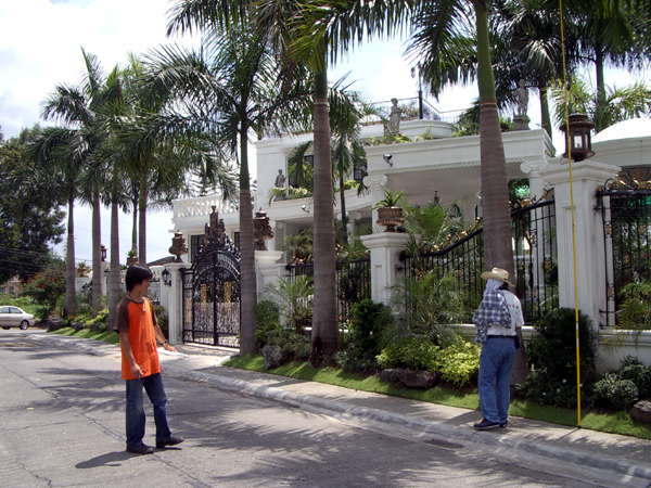
This case study was conducted to better understand the present situation of green spaces in Marikina City, in the suburbs of metropolitan Manila, a typical large Asian city. Changes in landuse and green space in relation to the urbanization process were investigated through examination of aerial photographs. GIS was used for data analysis. Landuse changes advanced according to the ease of development as affected by landform. Urbanization proceeded on all types of landforms, and as a consequence, green spaces significantly decreased in all landuse categories. Residential area was the most quickly expanding landuse, but green spaces in individual residential lots seem to be very important. A vegetation survey was conducted in residential districts of Marikina City, and the quantitative and qualitative characteristics of trees were analyzed. Lot size had some influence on the quantity of greenery in residential lots. In smaller lots, however, quantity did not increase in proportion to lot size. It appears, then, that the landuse controls for individual lots did not function effectively. Quantitative differences of greenery were related to qualitative differences, depending on the year or period of development of the residential area. In the newly developed residential lots, the greenery is comprised mostly of ornamental trees. Under the present circumstances, there is no assurance of sustaining the desired quantity of greenery in smaller residential lots. In the future, planners should promote consensus building with local residents about the conservation and creation of green spaces on their private lands as well as enhance landuse control.
View full abstract
-
Shigeru Shirasa
Pages
12
Published: 2005
Released on J-STAGE: November 30, 2005
CONFERENCE PROCEEDINGS
FREE ACCESS
-
Yoshinori Nagano
Pages
13
Published: 2005
Released on J-STAGE: November 30, 2005
CONFERENCE PROCEEDINGS
FREE ACCESS
-
a case study of Mt.Ege park in Hiroshima city
Toshihisa ASANO
Pages
14
Published: 2005
Released on J-STAGE: November 30, 2005
CONFERENCE PROCEEDINGS
FREE ACCESS
-
Yoshitaka Fukuoka, Futoshi Matsumoto, Sachiko Shirashiki
Pages
15
Published: 2005
Released on J-STAGE: November 30, 2005
CONFERENCE PROCEEDINGS
FREE ACCESS
-
Case study in Numata city, Gunma Prefecture
TERUO HATAKEYAMA
Pages
16
Published: 2005
Released on J-STAGE: November 30, 2005
CONFERENCE PROCEEDINGS
FREE ACCESS
-
Fumiaki Fujibe, Nobuo Yamazaki, Kenji Kobayashi
Pages
17
Published: 2005
Released on J-STAGE: November 30, 2005
CONFERENCE PROCEEDINGS
FREE ACCESS
-
NOBUYUKI IWAMA
Pages
18
Published: 2005
Released on J-STAGE: November 30, 2005
CONFERENCE PROCEEDINGS
FREE ACCESS
-
Dan BALTEANU, Mihaela SERBAN, Ana POPOVICI
Pages
19
Published: 2005
Released on J-STAGE: November 30, 2005
CONFERENCE PROCEEDINGS
FREE ACCESS
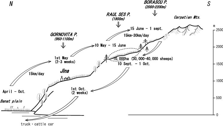
The transition period in Romania, which began at the end of 1989, represented basically the passage from the old centralized socialist system to the new free-market economy. One of the first economic branches to be hit by the restructuring process was agriculture, in which former collective and state ownership over the land was replaced by private property, with over 90% of the total agricultural surface having been redistributed. Private property has become dominant in all categories of land use, holding 96.3% arable land, 96.4% natural pastures and hay-fields, and 94.7% vine-yards and orchards (2003). A main outcome of privatization in the primary sector was the excessive fragmentation of the agricultural terrain into very small parcels (> 2 ha in the majority of cases) and the dissolution of large farms into individual smallholdings, a situation that has a strong impact on the environment. Since the new owners were short of money, the quality of some terrains kept degrading.Arable terrains, as well as fruit-and-wine growing areas shranked in favour of other destinations such as pastures and hay-fields, the cultivated surface decreasing from 9.8 million hectares in 1989 to 8.5 million hectares in 2000; the growth of cereals, of maize in particular, was extended to the detriment of other crops – textile and oil plants (with the exception of sun-flower), sugar-beet, potatoes and vegetables; defective agricultural practices and other causes lowered total productions and average yield per hectare.Natural processes (landslides, erosion, floods and droughts) alongside the anthropic factors (inadequate agricultural practices, deforestation, the use of fertilizers and frequently of heavy machines and equipment, overgrazing, deficient rotation of crops, and irrigation) combined to degrade the quality of agricultural terrains. Also, evident changes in the regime of rainfalls and temperatures contributed to the processes of land degradation. Industrial activities, especially mining, which affected some 21 000 hectares, enhanced soil degradation. Shepherding, forestry and mining are traditional activities in the Romanian Carpathian Mountains. Romania has the largest Alpine meadows and wetlands (in the Danube floodplain, the Danube Delta and the West Plain) in Europe. Together with their complementary resources these areas represented a favourable background for the practice of transhumance ever since Antiquity. In the Middle Ages, Romanian shepherds would move northwards, as far as Poland, and southwards, up to the Dalmatian coast, imposing the Wallachian traditions of "jus valachicum" and "quin quagesima ovium" (Geografia României, III, 1987).Shepherding would develop especially in the inter-war period, when the number of sheep increased and transhumant distances became ever longer, reaching Crimea. In the communist period mountain villages were not collectivised, so transhumant shepherding continued, and moreover, exports of sheep wool and meat, particularly to the Arab countries, were stimulated. In the first years after the 1989 revolution, this activity decreased considerably, but having been significantly revigorated over the past few years.The pastoral villages situated in the north of the Carpathian Mountains (our case-study) have a traditional character. At present, transhumance is practiced in two ways:- big transhumance which means movement over long distances, as far as Banat and Crisana (in the west of Romania) and Dobrogea (in the south-east of Romania);- small transhumance which covers much smaller areas to neighbouring villages only (the Sibiu Depression and the Transylvanian Plain).The paper analyses transhumance as practiced in the villages of Marginimea Sibiului, identifying different historical periods and looking at the present particularities of this phenomenon.
View full abstract
-
Ena KONNO, Daichi ISHIHARA, Takashi ISONO, Nagatada TAKAYANAGI, Yoshio ...
Pages
20
Published: 2005
Released on J-STAGE: November 30, 2005
CONFERENCE PROCEEDINGS
FREE ACCESS
-
Masahiro Kagami
Pages
21
Published: 2005
Released on J-STAGE: November 30, 2005
CONFERENCE PROCEEDINGS
FREE ACCESS
-
Sadao Iida, Akira Eguchi, Satoshi Shimura, Toru Oshima
Pages
22
Published: 2005
Released on J-STAGE: November 30, 2005
CONFERENCE PROCEEDINGS
FREE ACCESS
-
Akiko IKEGUCHI
Pages
23
Published: 2005
Released on J-STAGE: November 30, 2005
CONFERENCE PROCEEDINGS
FREE ACCESS
-
JUNYA TATEMI
Pages
24
Published: 2005
Released on J-STAGE: November 30, 2005
CONFERENCE PROCEEDINGS
FREE ACCESS
-
Shinzou Ooi, Yoshiharu Yokoyama
Pages
25
Published: 2005
Released on J-STAGE: November 30, 2005
CONFERENCE PROCEEDINGS
FREE ACCESS
-
Hitoshi ARAKI, Makoto TAKAHASHI
Pages
26
Published: 2005
Released on J-STAGE: November 30, 2005
CONFERENCE PROCEEDINGS
FREE ACCESS
-
Hitoshi ARAKI, Massashi IKEDA
Pages
27
Published: 2005
Released on J-STAGE: November 30, 2005
CONFERENCE PROCEEDINGS
FREE ACCESS
-
The Cities of Yanagawa, Omihachiman, Sawara and Itako
Kayoko Yamamoto
Pages
28
Published: 2005
Released on J-STAGE: November 30, 2005
CONFERENCE PROCEEDINGS
FREE ACCESS
In recent years, attention is being given to community design that makes the most of the water environment of towns and cities on rivers, canals, moats, waterways, lakes and seas, and the development and revitalization of these waterside spaces. Across the country, various projects to harness the distinctive characteristics of these areas have been promoted vigorously. Examples of such projects include waterfront community design in water-abundant districts such as the valleys of large rivers, and waterfront areas of lakes and sea shores, and community design for cities on water that utilizes the rivers, canals and moats in urban districts. In this paper, the author will treat examples of cities in which community design is taking place that makes the most of their regional characteristics as waterfront areas and their history and traditions related to water, with the aim of grasping their distinctive characteristics.
View full abstract
-
Shingo ITOU
Pages
29
Published: 2005
Released on J-STAGE: November 30, 2005
CONFERENCE PROCEEDINGS
FREE ACCESS
-
Takahito KUROKI, Nozomi ISO, Kensuke GOTO, Masato NAKAMURA, Takefumi K ...
Pages
30
Published: 2005
Released on J-STAGE: November 30, 2005
CONFERENCE PROCEEDINGS
FREE ACCESS
-
-Case study of Ushita district and San-in area-
Takashi WADA
Pages
31
Published: 2005
Released on J-STAGE: November 30, 2005
CONFERENCE PROCEEDINGS
FREE ACCESS
-
Masatomo UMITSU
Pages
32
Published: 2005
Released on J-STAGE: November 30, 2005
CONFERENCE PROCEEDINGS
FREE ACCESS
-
Junji Nishina, Takehiko Mikami
Pages
33
Published: 2005
Released on J-STAGE: November 30, 2005
CONFERENCE PROCEEDINGS
FREE ACCESS
-
Takuya GOTO
Pages
34
Published: 2005
Released on J-STAGE: November 30, 2005
CONFERENCE PROCEEDINGS
FREE ACCESS
-
Kazuki Mori
Pages
35
Published: 2005
Released on J-STAGE: November 30, 2005
CONFERENCE PROCEEDINGS
FREE ACCESS
Hydrological investigations were conducted through August into September 2003 and Agust 2004 in River Cibin, the Danube drainage system in the south-western part of the Carpathians, central Romania. The main purpose of the present paper is to clarify the actual circumstances of water pollution in the headwaters basin due to human activity. The results are summarized as follows: 1. A concentration of dissolved substances in river water shows the maximum value at the uppermost observation point and decreases by flowing downward with an effect of dilution. Such a characteristic spatial change in river water quality is significantly affected by untreated household effluent and raw sewage from settlement, which is located in the mountain ridge. 2. During summer season, a striking contamination of river water is found at some peculiar points where sheared wool is directly washed un river channel attendant upon sheep-breeding. 3. From the viewpoint of primary factor having effects on water quality, river water and groundwater in the watershed are clearly classified into some categories according to the difference in concentration and composition of major dissolved substances. It is pointed out that the distinguishing features of water quality are consistent with the way of land use and water use.
View full abstract
-
Yasunori Sawada
Pages
36
Published: 2005
Released on J-STAGE: November 30, 2005
CONFERENCE PROCEEDINGS
FREE ACCESS
-
-Case of new town area -
Kazuyoshi YOSHIDA
Pages
37
Published: 2005
Released on J-STAGE: November 30, 2005
CONFERENCE PROCEEDINGS
FREE ACCESS
-
Masatomo UMITSU, Charlchai TANAVUD, Patanakanog BOONRAK
Pages
38
Published: 2005
Released on J-STAGE: November 30, 2005
CONFERENCE PROCEEDINGS
FREE ACCESS
-
Some focus points after Heisei municipal amalgamation policy
SHIN KAJITA
Pages
39
Published: 2005
Released on J-STAGE: November 30, 2005
CONFERENCE PROCEEDINGS
FREE ACCESS
-
Azusa FUKUSHIMA, Hideo TAKAHASHI
Pages
40
Published: 2005
Released on J-STAGE: November 30, 2005
CONFERENCE PROCEEDINGS
FREE ACCESS
-
Research on browsing behavior of grazing cattle by potable GPS together with bite-counter collar
Hiroaki Maruyama, Takaaki Nihei
Pages
41
Published: 2005
Released on J-STAGE: November 30, 2005
CONFERENCE PROCEEDINGS
FREE ACCESS
-
Hiroshi P. SATO, Satoshi MIYASAKA, Satoru KATO
Pages
42
Published: 2005
Released on J-STAGE: November 30, 2005
CONFERENCE PROCEEDINGS
FREE ACCESS
Naganuma park (c.a. 0.9 km
2 in area) in Hachioji city, Tokyo is located on the western Tama Hill, and coppice forest, mainly Quercus serrata, extends in the park. In advance, the coppice regeneration locations and years mapped by the park management office was digitized. Next, vegetation height was measured by airborne LIDAR survey, and it was superimposed on the digitized map.
As a result, it was found that there is high linear correlation between vegetation height and coppice regeneration year (correlation coefficient: -0.85).
View full abstract
-
A Case Study of Agricultural Corporation of Toyama Prefecture
Nobuo OTAKE
Pages
43
Published: 2005
Released on J-STAGE: November 30, 2005
CONFERENCE PROCEEDINGS
FREE ACCESS
-
Tatsuo Sekiguchi, Satoshi Fujiwara
Pages
44
Published: 2005
Released on J-STAGE: November 30, 2005
CONFERENCE PROCEEDINGS
FREE ACCESS
-
Tatsuo Sekiguchi, Hiroshi P. Sato
Pages
45
Published: 2005
Released on J-STAGE: November 30, 2005
CONFERENCE PROCEEDINGS
FREE ACCESS
-
Toshio Koizumi
Pages
46
Published: 2005
Released on J-STAGE: November 30, 2005
CONFERENCE PROCEEDINGS
FREE ACCESS
-
Dai Wang
Pages
47
Published: 2005
Released on J-STAGE: November 30, 2005
CONFERENCE PROCEEDINGS
FREE ACCESS
-
Akiko Ikeguchi, Haruo Saito, Yoshinao Adachi, Ken-ichi Nonaka
Pages
48
Published: 2005
Released on J-STAGE: November 30, 2005
CONFERENCE PROCEEDINGS
FREE ACCESS
-
Kazuko URUSHIBARA-YOSHINO, Kazuki MORI, Shigeru SHIRASAKA, Dan BALTEAN ...
Pages
49
Published: 2005
Released on J-STAGE: November 30, 2005
CONFERENCE PROCEEDINGS
FREE ACCESS
-
Integrated Curriculum of Geography Education
Takashi HIHARA
Pages
50
Published: 2005
Released on J-STAGE: November 30, 2005
CONFERENCE PROCEEDINGS
FREE ACCESS