- |<
- <
- 1
- >
- >|
-
2023 Volume 132 Issue 1 Pages Cover01_01-Cover01_02
Published: February 25, 2023
Released on J-STAGE: March 09, 2023
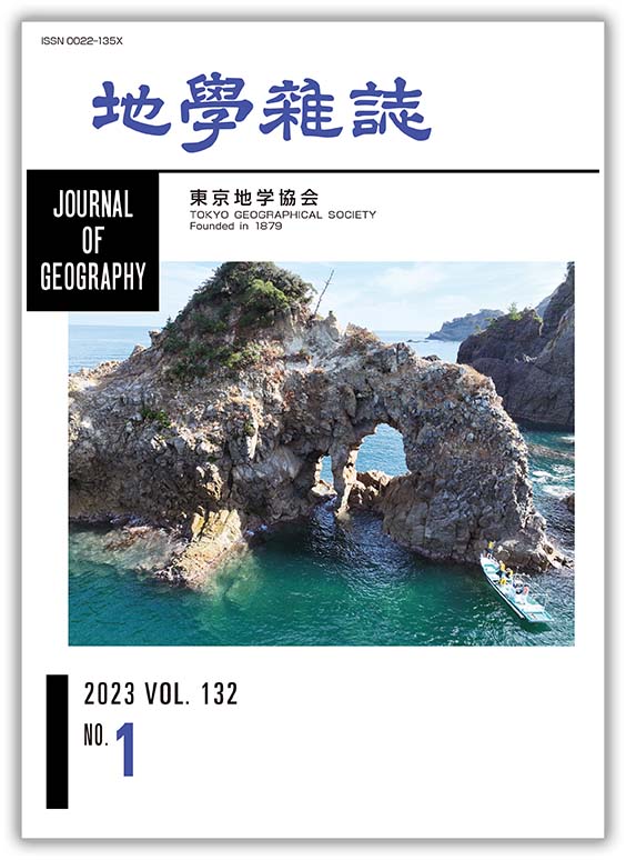
JOURNAL FREE ACCESSWave erosion produces a variety of marine cavernous forms along rocky coasts. The San'in Coast is a ria coast composed of extensive rocky cliffs that include more than one hundred marine caves. The cover image shows a sea arch formed at an island composed of rhyolite rocks, which was taken using a camera mounted on an UAV. A small boat (lower-right corner) was used for investigating marine caves at inaccessible sea cliffs or offshore islands. We measured the strength and structure of bedrock from the bow of the boat and launched an UAV from the boat to take aerial images from various directions. These aerial images were combined to produce 3-D models of cavernous forms, from which topography and rock structure were analyzed.
(Photograph: Takuro OGURA, Photographed on September 26, 2022; Explanation: Norikazu MATSUOKA)
View full abstractDownload PDF (2957K)
-
Harue MASUDA2023 Volume 132 Issue 1 Pages 1-16
Published: February 25, 2023
Released on J-STAGE: March 09, 2023
JOURNAL FREE ACCESSOccurrences of non-volcanic hot and mineral spring waters, found in Niigata and the surrounding areas, as well as central to southern Kinki District, are documented in relation to the local tectonics to discuss on the importance of plate tectonics as sources of heat and dissolved chemical compositions in the deep groundwater/fluid cycle. Fossil seawater was altered at different temperatures, and remains as low-temperature mineral waters in Gunma Prefecture, and as oil and gas field brine and related hot springs in Niigata Prefecture and surrounding areas. One of the hot springs in Niigata, i.e., Matsunoyama Hot Spring, is known to contain geo-pressure hydrothermal water. The brines in Niigata Prefecture are heated via tectonics at the boundary between the Eurasian and North-American plates without contaminating modern local meteoric water. In the Kinki District, hot spring waters > 40°C appear only in three regions: coastal area along the Sea of Japan, Arima and surrounding area of Osaka Basin, and southern part of Kii Peninsula. In this area, mantle-derived fluids, such as He and CO2, are upwelling with slab-derived saline waters from the subducting Philippine Sea Plate. Non-volcanic hot spring waters occasionally give the important information on heat and energy cycles at the plate boundaries, as well as valuable information for understanding the mechanisms of inland earthquakes related to the deep-fluid movements.
View full abstractDownload PDF (5263K)
-
Hiroshi MATSUYAMA2023 Volume 132 Issue 1 Pages 17-31
Published: February 25, 2023
Released on J-STAGE: March 09, 2023
JOURNAL FREE ACCESSGiven the lack of studies on the characteristics of precipitation at Haha-jima, Ogasawara (Bonin) Islands, they are investigated using daily precipitation data from AMeDAS Haha-jima (August 30, 2007-December 31, 2020) and the Oki-mura Water Supply Branch of Ogasawara Village (January 1, 1978-December 31, 2017). A regression equation is produced to estimate daily precipitation at AMeDAS using data at Oki-mura for each month; then, they are applied to estimate daily precipitation at AMeDAS from January 1, 1978 to August 29, 2007. The monthly precipitation analysis for the period from January 1978 to December 2020 reveals that precipitation in February at Haha-jima decreased with a 5% significance level. In contrast, precipitation in September at Chichi-jima increased with a 5% significance level. A comparison between the histograms of daily precipitation on both islands in the former (1978-1999) and latter (2000-2020) periods reveals that in February 2000-2020, precipitation of 10-19 mm/day class on both islands decreased, along with a decrease of 20-29 mm/day class at Haha-jima. During the period September 2000-2020, the maximum daily precipitation on both islands surpassed previous records, and precipitation of 70-89 mm/day class increased on both islands. Most of the heavy daily precipitation occurred either during the approach or the passage of a tropical depression or a typhoon.
View full abstractDownload PDF (4404K) -
Kanami SHINOHARA, Atsuya ITO, Takuro OGURA, Norikazu MATSUOKA2023 Volume 132 Issue 1 Pages 33-55
Published: February 25, 2023
Released on J-STAGE: March 09, 2023
JOURNAL FREE ACCESS
Supplementary materialMarine cavernous landforms, including notches, caves, arches and tunnels, characterize the rocky coast landscape and are strongly influenced by the geology (e.g., rock strength and structure) of sea cliffs. Geological controls on the development and shape of marine cavernous landforms are evaluated based on field investigations along the Pacific coastlines of Honshu Island, Japan. Morphological parameters, width (w), depth (d), and height (h), of cavernous landforms were measured directly or through images taken with an unmanned aerial vehicle, together with geological factors, such as rock types, strength (Schmidt hammer rebound values: R), dips and strikes of bedding, major joints, and fault planes. In total, 76 caves are investigated in six coastal areas: Sanriku Coast, Joban Coast, Boso Peninsula, Miura Peninsula, Izu Peninsula, and Kii Peninsula. According to shape index, d/w, and presence of the open end, cavernous landforms are classified into notches (d/w < 1, closed end), caves (d/w ≥ 1, closed end), arches (d/w < 1, open end), and tunnels (d/w ≥ 1, open end). An analysis shows that the major geological controls differ between notches and the other three forms. Low rock strength (R < 40) and sub-horizontal bedding are, respectively, the primary and secondary controls on the formation of notches, whereas weak rock structures (joints, faults and bedding) with a dip steeper than 30° (vertical or steeply inclined structures) and a strike trending perpendicular to the cliff face are the major controls on the formation of caves, arches and tunnels. Rock strength also affects planar forms defined by the shape index, promoting a deepening of cavernous forms, particularly when the cliff has a medium rock strength (R = 30-50) that provides an optimal balance between erosion force and resisting force. In general, vertical or steep structures contribute to the deepening of holes, whereas horizontal or gentle structures favor widening.
View full abstractDownload PDF (5902K)
-
Takuya HARADA, Mitsuhiro NAGATA, Yasuhiro OGITA, Saya KAGAMI, Tatsunor ...2023 Volume 132 Issue 1 Pages 57-65
Published: February 25, 2023
Released on J-STAGE: March 09, 2023
JOURNAL FREE ACCESS
Supplementary materialThe Harachiyama Formation comprises Lower Cretaceous volcanic rocks, which are distributed in the eastern margin of the Kitakami Mountains in northeastern Japan. Whole-rock chemical analysis, U–Pb zircon dating and Hf isotope analysis of the Harachiyama Formation were performed to constrain the formation age and the magmatic origin was discussed. The lava and tuff samples of the Harachiyama Formation from the Omoto and Tsukue areas supported island-arc rhyolitic rocks (SiO2 content > 70%), and yielded the weighted mean U–Pb ages of 127.8 ± 3.4 Ma and 129.2 ± 2.6 Ma (2σ), respectively. Eighteen zircon grains from two samples, dated between 141.6 Ma and 123.9 Ma, yielded positive εHf(t) values between +5.0 and +8.7. The U–Pb ages and εHf(t) values are consistent with those of the Kitakami Granitoid reported in previous studies. Therefore, it is suggested that the Early Cretaceous volcanic rocks in northeastern Japan, such as the Harachiyama Formation, have the same magmatic origin as the Kitakami Granitoid.
View full abstractDownload PDF (3017K)
- |<
- <
- 1
- >
- >|