- Issue 6 Pages 447-
- Issue 5 Pages 335-
- Issue 4 Pages 241-
- Issue 3 Pages 143-
- Issue 2 Pages 63-
- Issue 1 Pages 1-
- |<
- <
- 1
- >
- >|
-
2024Volume 133Issue 2 Pages Cover02_01-Cover02_02
Published: April 25, 2024
Released on J-STAGE: May 15, 2024
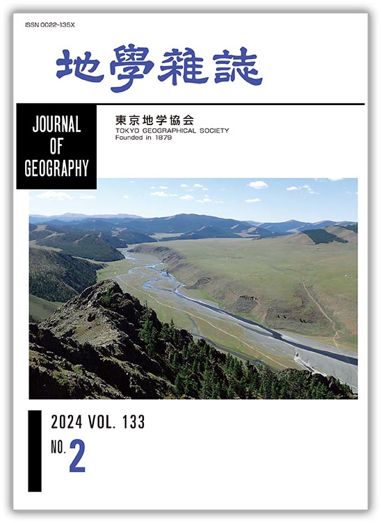
JOURNAL FREE ACCESSReaders might imagine that huge deserts and extensive sheep-filled grasslands are typical landscapes of Mongolia; however, it is a mountainous country. To the north and west there are wild, non-vegetated hills and rugged ridges, with high snow-covered peaks reminiscent of the European Alps. The Khangai mountains in central Mongolia, extending ca. 1000 km in length and ca. 200 km crosswise, form a dominant massif composed mostly of Paleozoic orogenic products, such as accretionary complexes, volcanics/granitoids, blueschists, and ophiolites. The cover photo shows a typical landscape of the mid-Khangai mountains, along the upper reaches of the Orkhon River. The exposed basement rocks are components of the Devonian accretionary complex, e.g., bedded chert: a section of ancient deep-sea floor from the Paleo-Asian Ocean. From a prominent chert ridge, we can clearly observe well-preserved natural landforms, such as a sedimentary fan and braided river system, free from obstacles (vegetation and human artefacts), with nomadic gels (temporary tent-like structures) providing scale. The flat plane on the opposite riverbank is not a river terrace but a flow surface of Quaternary flood basalt. Japanese readers may have read the popular historic novel Pale Wolf by Yasushi Inoue, based on the ancient document The Secret History of the Mongols, which tells the life story of Genghis Khan. The Orkhon River appears often in this novel, reminding us of the frequent long journeys he made across this river with his warriors and family. The natural landscape appears not to have changed much in the millennium since the time of Genghis Khan.
(Photograph & Explanation: Yukio ISOZAKI)
View full abstractDownload PDF (1832K)
-
Ryo MATSUMOTO, Akihiro HIRUTA, Takeshi OI, Yoshihiro KAKIZAKI, Takaya ...2024Volume 133Issue 2 Pages 63-89
Published: April 25, 2024
Released on J-STAGE: May 15, 2024
JOURNAL FREE ACCESSDue to the current energy crisis caused by global warming and geopolitical events, evaluating the energy potential of marine gas hydrates around the Japan Islands has become an urgent issue. Based on open and public reports, a critical overview is provided of the current status of the exploration of gas hydrates in the eastern Nankai Trough and along the eastern margin of the Japan Sea. In 2001, an exploration and resource assessment of gas hydrates in the eastern Nankai Trough was launched as a national project. In the late 20th century, hydrate-induced BSRs had been widely recognized on the fore-arc basins and slopes of the accretionary wedges of the Nankai Trough. Integrated geological and geophysical exploration reveals that the hydrates of the eastern Nankai Trough occur in the interstitial pore space of sand layers (pore filling type) of the Early Pleistocene turbidite units of 100 to 200 m in thickness above the BSR-BGHS. Hydrate exploration in the Japan Sea entered the National project in 2012, following academic efforts over the preceding 10 years, confirming 1,742 columnar-shaped gas chimney structures (generally a few hundred meters across and roughly 100 m deep) in which a few centimeters to nearly 50 m of thick massive hydrate deposits occur in the Middle Pleistocene silty host sediments. Japan Sea hydrates are considered to have grown in the host sediments, displacing clayey particles (particle displacement type). Gas chimney structures are the main conduits for the migration of deep-seated methane, associated with sea floor methane seeps, chemosynthetic communities, and methane-derived authigenic carbonates. A high concentration of massive hydrate is related to enhanced maturation and accumulation of hydrocarbon deposits under the high heat flow of the Japan Sea basin. Additionally, glacial eustasy of the closed Japan Sea basin facilitated efficient recycling of methane to accumulate massive hydrates.
View full abstractDownload PDF (7893K)
-
Masatake HARADA, Akio YOSHIDA2024Volume 133Issue 2 Pages 91-100
Published: April 25, 2024
Released on J-STAGE: May 15, 2024
JOURNAL FREE ACCESSThe most serious situation from the viewpoint of disaster prevention in activity at Hakone volcano is a burst of volcanic gases and hot steam, as observed in 2001 and 2015. Using GNSS data and based on Mogi's model, it is found that the pressure sources of activity in 2001 and 2015 are relatively shallow compared to other sources of volcanic activity. Whether a pressure source is relatively shallow or not can be easily distinguished by noting changes in distance between GNSS observation sites at Odawara and Hakone. If the distance decreases, the pressure source is considered to be shallow. The extent of volcanic activity differs each time and only two cases of recent activity are known where dangerous surface phenomena are observed. Therefore, it cannot be said that volcanic activity with a shallow pressure source would always be hazardous and activity with a relatively deep source would not become dangerous. However, making use of empirical knowledge, it is believed to be meaningful to monitor volcanic activity more carefully when the pressure source is estimated to be relatively shallow.
View full abstractDownload PDF (3813K) -
Tanio ITO, Ken'ichi KANO, Go SATO, Akira FUJIWARA, Toshiki WATANABE, M ...2024Volume 133Issue 2 Pages 101-128
Published: April 25, 2024
Released on J-STAGE: May 15, 2024
JOURNAL FREE ACCESS
Supplementary materialThe Fujikawa-kako fault zone (FKFZ) is one of the most active fault zones constituting the northwest border of the Izu collision zone between the Honshu and Izu arcs. Its vertical slip rate is estimated to reach 6 to 7 m/ky along the eastern margin of FKFZ. In order to elucidate the causes of such high fault activities, the structure of this fault zone from the seismogenic zone to the surface is revealed. An integrated seismic exploration, which links several seismic exploration techniques, is employed. Thus, a two-stage integrated seismic exploration is designed and carried out. The first stage, named FIST2012, aims to reveal the shallow to deep structures of the upper surface of the Philippine Sea Plate (PHS), FKFZ and Itoigawa-Shizuoka Tectonic Line (Fujiwara et al., 2024). The second stage, named Multi-line Hoshiyama 2015 attempts to elucidate the three-dimensional structure of the Omiya fault (Omy) and the Iriyamase fault (Irs) from the seismogenic zone to the surface, both of which form the eastern margin of FKFZ. The main purpose is to present the outcomes of the second stage, and to discuss any remaining problems. The results are as follows. Omy consists of the Sole thrust (St) and the Roof thrust (Rt), which together form a N30°W trending wedge-thrust structure, whereas Irs mainly consists of two segments: N50°E-trending Fa and N48°E-trending Fd. Fa originates from St of Omy as a reverse fault. On the other hand, Fd plays a role in a tear fault of St. The three-dimensional structure of Omy and Irs shows that both faults form a single active fault system driven by the thrust motion of St, which connects with the branching fault from the upper surface of PHS. This means that the high fault activities of FKFZ directly reflect the motion of PHS. Although the outcomes are significant, major problems remain. Firstly, ages cannot be assigned to depth sections due to the lack of geological and geophysical data from boreholes, with the exception of two shallow boreholes. This prevents precise interpretations of depth sections from being completed. Thus, geological and geophysical data from boreholes are urgently needed. Secondly, the N60E-trending thrust motion on N30W-trending St seems to contradict the NW-trending PHS motion relative to the Honshu arc, even though St connects with the branching fault that originates from the upper surface of PHS. The structural relationship between the two motions between St and PHS is still unresolved. To address this issue, the three-dimensional geometry of the upper surface of PHS where the branching fault originates needs to be understood.
View full abstractDownload PDF (12351K)
-
Kensuke SUZUKI, Hitoshi SAITO, Hiroshi MATSUYAMA2024Volume 133Issue 2 Pages 129-141
Published: April 25, 2024
Released on J-STAGE: May 15, 2024
JOURNAL FREE ACCESS
Supplementary materialPrecipitation events from March 1 to 7 are analyzed in the Aso region, central Kyushu, based on local traditional event known as “Noyaki” (controlled burning), held on the first Sunday of March, which has been postponed in recent years. During the period 2002-2009, precipitation was not observed on the first Sunday of March at the Aso-Otohime Station of the Automated Meteorological Data Acquisition System (AMeDAS), whereas it was frequently observed during the period 2010-2021. The number of rainy days from March 1 to 7 at AMeDAS stations throughout Kyushu during the period 2010-2021 was greater overall than that during the period 2002-2009, with a statistically significant increase confirmed at eight stations located in the eastern–southeastern part of Kyushu. Precipitation from March 1 to 7 increased throughout Kyushu, with the exception of the northern part during the period 2010-2021, whereas the intensity of precipitation did not show any statistically significant change at the AMeDAS stations as a whole. Therefore, it is considered that the increase in rainy days is responsible for the frequently observed rainfall and the increase in precipitation around the Aso region during the period 2010-2021. From the run test, it is concluded that there will be regularity in the series of the presence/absence of precipitation at AMeDAS Aso-Otohime Station in the future, whether or not there is precipitation on the first Sunday of March. When precipitation persists, regularity emerges, suggesting a long-term increasing trend in the increase of precipitation events, while the absence of precipitation suggests that the recent increase in precipitation events is a component of cyclical variations.
View full abstractDownload PDF (1857K)
- |<
- <
- 1
- >
- >|