- Issue 6 Pages 565-
- Issue 5 Pages 479-
- Issue 4 Pages 393-
- Issue 3 Pages 289-
- Issue 2 Pages 125-
- Issue 1 Pages 1-
- |<
- <
- 1
- >
- >|
-
2022 Volume 131 Issue 4 Pages Cover04_01-Cover04_02
Published: August 25, 2022
Released on J-STAGE: September 08, 2022
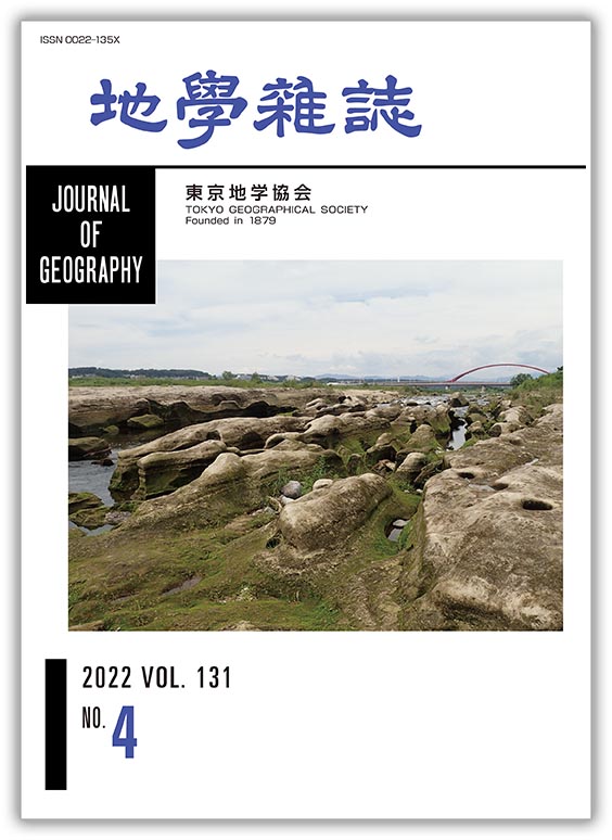
JOURNAL FREE ACCESSIn 1961, an Eschrichtius akishimaensis fossil was discovered at Akishima City, Tokyo, in the Tama Riverbed beneath a railway bridge on the JR Hachiko Line. The fossil was excavated from the Komiya Formation (equivalent to the Hirayama Formation) of the Kazusa Group, suggesting that at least two lineages of the genus Eschrichtius survived in the Early Pleistocene. Downstream from the excavated site, many island-like landforms of about 2 m in height developed parallel to the river flow. The grooves between the islands are long and narrow downstream. When the water level rises, the islands look like a swimming herd of cattle, which is why Koizumi (1996) called them “herd-like landforms (gyugun tikei).” Gravel was actively extracted from the bed of the Tama River from around the Meiji era until 1968. There were as many as 104 gravel pits (as of the end of fiscal year 1963) between Ome City and Komae City. Gravel extraction triggered exposure of the Komiya Formation, which consists mainly of semi-consolidated sand, and the water flow gradually carved longitudinal channels, forming the landforms shown in the photo, which are rarely seen elsewhere in the world. Unlike fossils, the herd-like landforms do not remain and are gradually lost, showing the framework of the Anthropocene.
(Photography & Explanation: Tetsuya WARAGAI)
View full abstractDownload PDF (2007K)
-
Yihui YANG, Kenichi UENO2022 Volume 131 Issue 4 Pages 393-405
Published: August 25, 2022
Released on J-STAGE: September 08, 2022
JOURNAL FREE ACCESSFew studies have revealed the statistical tendencies of occurrences for cloud, fog, heavy rain or snowfall that characterizes mountain weather variabilities in Japan. Characteristics of seasonal and diurnal variations in fog and mist discriminated by visibility, precipitation types and precipitation intensity were clarified using data from November 2010 to October 2020 observed by Vaisala present weather sensor in the Sugadaira highland (1,320 m), Nagano Prefecture in Japan. Mist appeared more frequently than fog, and both increased in frequency at night. Fog prevailed in spring and autumn, while mist prevailed in the summer. In contrast, mist at the Nagano Local Meteorological Office (418 m) occurred frequently in the cold season and in the early morning. The frequency of snow and sleet decreased in the daytime. Sleet was infrequent but prevailed in December and March with the passing of south-coast cyclones and twin cyclones. The occurrence of freezing precipitation was very rare, but some intensive periods were found. Strong rain rates dominated from July to September, especially in the evening, and moderate and weak rain rates dominated in June or October when the Baiu front or typhoon prevails. There was no clear difference in seasonal/diurnal change depending on the snowfall intensity. The frequency for strong-intensity snowfall increased in cases of passing south-coast or twin cyclones. Instead of previous low-frequently visible observation, the characteristics derived by high-temporal long-term data could be utilized as validation data for satellite observation or numerical experiments.
View full abstractDownload PDF (1672K) -
Satoshi YOSHIDA, Yukio ISOZAKI, Tomohito NAKANO, Yukiyasu TSUTSUMI2022 Volume 131 Issue 4 Pages 407-425
Published: August 25, 2022
Released on J-STAGE: September 08, 2022
JOURNAL FREE ACCESS
Supplementary materialUranium–Pb ages of detrital zircons taken from seven sandstone samples collected at what were previously called “Paleogene strata” in the Nagasaki and Nishisonogi Peninsula, northwestern Kyushu, SW Japan are measured. Depositional ages of three sandstones in the Nagasaki peninsula are revealed to be e Campanian–Maastrichtian (Late Cretaceous) or younger. Depositional ages of two sandstones in Terashima Island off the west coast of the Nishisonogi Peninsula are likewise dated as Campanian or younger. By contrast, two sandstones in western Nagasaki Peninsula are confirmed as the Ypresian–Lutetian (Eocene) or younger. These new ages are concordant with sporadically reported mollusk fossils, basically supporting the previous stratigraphic scheme, except for a distinct Upper Cretaceous strata called the Mitsuze Formation. The age spectra of detrital zircons from the four Campanian sandstones share the same pattern; i.e., ranging in the Aptian–Campanian with a peak around the Cenomanian. The Maastrichtian sandstone has grains ranging in the Albian–Maastrichtian with a peak around the Turonian, which is slightly younger than that of Campanian sandstones. Judging from the dominance of Middle Cretaceous zircon grains, the main provenances of the sandstones are probably the Ryoke/San-yo and San-in granite belts in SW Japan, where Middle to Late Cretaceous felsic igneous rocks are extensively exposed. The age spectra of detrital zircons in the Campanian–Maastrichtian sandstones are almost identical to those of the Himenoura and Mifune groups in central Kyushu, and the Izumi Group in Shikoku/western Kii peninsula. All of these units were deposited unconformably over the Ryoke granitoids. Within the elongated arc-trench system extending for over 1,300 km from western Kyushu to northern Kanto, Mitsuze Formation sandstones in the Nagasaki-Nishionogi Peninsula mark the known western end of the large-scale Upper Cretaceous fore-arc basin in Japan.
View full abstractDownload PDF (5461K) -
Naoko NAGUMO, Shinji EGASHIRA2022 Volume 131 Issue 4 Pages 427-445
Published: August 25, 2022
Released on J-STAGE: September 08, 2022
JOURNAL FREE ACCESSAt the mouth of the Sittaung River in Myanmar, a tide-dominated estuary has developed, with a typical funnel-shaped planform. Tidal bores are formed during the spring tide. This study of the interaction of flows, sediment transportation, and landforms in the estuary, reveals the mechanism of multi-decadal estuarine landform evolution. Our analyses, using time-sequence topographic maps and satellite images, as well as field surveys, found that the main channel has been shifting its course for at least the last 100 years, which has caused alternating retreats and advances of the right and left bank lines, in cycles of around 20 years. This periodicity is evidenced by the developments of a smooth bank line due to erosion and a saw-tooth bank line due to adjuncts of bars and formations of rills to drain surface and subsurface water, and by changes in locations of villages. The main causes of active bank erosion are tidal bores and associated flood currents, which undercut bank bottom sediment and induce toppling failures of upper sediment blocks, causing an active bank line retreat and the supply of sediment into the estuary. The main-channel shifts and bank line changes can be schematically explained by two elementary processes: meander deformation and channel bifurcation. Channel shifts occur where sediment transport capacity decreases rapidly under the effect of fluvial flow and tidal currents. As a consequence, the main propagation route of tidal bores changes and erosion is newly promoted, which brings about further main-channel shifts and bed evolution of the estuary.
View full abstractDownload PDF (7242K)
-
Yoshihiko KARIYA, Satoru HARAYAMA, Yuki MATSUSHI, Yusuke SHIMIZU, Hiro ...2022 Volume 131 Issue 4 Pages 447-462
Published: August 25, 2022
Released on J-STAGE: September 08, 2022
JOURNAL FREE ACCESS
Supplementary materialThe geomorphological and geological characteristics, distributions, and ages of block slopes that developed at two alluvial cones (Bentenzawa valley and Okumatazirodani valley) along the Azusa River in the Kamikochi area, northern Japanese Alps, are clarified. These block slopes were believed to be of Pleistocene glacial origin in previous studies. A field survey was conducted, applying microtremor array observations to estimate subsurface geology, and in situ terrestrial cosmogenic nuclide (TCN) dating to estimate age of occurrence. At the Bentenzawa alluvial cone, the block slope is composed of large blocks and lithic fragments originating from heterogeneous igneous rocks, mainly of welded tuff and granophyre, that do not exist in the Bentenzawa valley watershed. Large blocks and lithic fragments of the block slope show clast-supported facies accompanied by jigsaw-crack fracture structures without a fine matrix. A mass of rock blocks fell from a steep wall of igneous rocks around the head of the Okumatajirodani valley, at approximately 2280 to 3090 m a.s.l., on the opposite side of the Bentenzawa valley. Rock slope failure and runout debris flow of blocks are thought to be the principal motions behind the mass movement from the rockwall. Block behavior comprised 3 km horizontal and 1.5 km vertical movements. Blocks were finally transported to the alluvial cone of the Bentenzawa valley to form an opposing impact slope. The results of microtremor array observations suggest that materials of rock blocks about 20 m thick spread and were buried beneath the present riverbed of the Azusa River. The estimated volume of landslide materials is more than 1.1 × 10⁷ m3; age is estimated to be 6900 ± 1000 yrs BP. The Bentennzawa block slope is not of glacial origin. The block slope at the Okumatajirodani alluvial cone consists of large lithic fragments of igneous rocks distributed in this watershed. A mass of rock blocks was supplied by slope failure or debris flow in the Okumatajirodani valley, and was transported and emplaced on the alluvial cone. The volume of the failure is estimated to exceed 2.9 × 10⁵ m3 and its age is estimated to be 900 ± 100 yrs BP.
View full abstractDownload PDF (6643K) -
Junko IWAHASHI, Akinobu ANDO, Yoshiharu NISHIOKA, Daisaku KAWABATA, Ta ...2022 Volume 131 Issue 4 Pages 463-472
Published: August 25, 2022
Released on J-STAGE: September 08, 2022
JOURNAL FREE ACCESS
Supplementary materialA system was created using an exploration-type computer game as the basic material, and its educational effects were verified with the aim of stimulating the interest of students of the digital native generation in the local history of the region. Research classes were conducted using Minecraft (Mojang/Microsoft) teaching materials at Miyagi University of Education Junior High School in Sendai City. The theme of the classes was to convey knowledge about the geology and geological history of the region. Teaching materials were created for students to learn about geological formations in the Kamisugi area of Sendai City, including the region of their junior high school, with the aim of deepening their interest in local geological history and their understanding of the changing earth. A Minecraft world was used with underground strata that reflected information from a geological boring survey conducted in the past at the school, school buildings, and teleportable landscapes of past geological eras, and questions were asked on knowledge of geology based on school textbooks or research papers. The following were confirmed from the research classes at the junior high school. The game using a familiar school as a setting was very popular among the students, and they were not bored by the knowledge questions. The key words of the geological era that the students reached were frequently mentioned in the questionnaire given after the classes. The game is considered to be effective for helping students to understand and remember things visually, while having an enjoyable and positive experience.
View full abstractDownload PDF (1360K)
-
Kunio OMOTO, Akiko IKEDA, Yoriko YOKOO2022 Volume 131 Issue 4 Pages 473-478
Published: August 25, 2022
Released on J-STAGE: September 08, 2022
JOURNAL FREE ACCESSA total of four muddy–fine sand deposits attached to the undersides of cobles and boulders and three Claudiconcha japonica fossils were collected to determine the formation age of conglomeratic beachrock developing at Sasebo, Nagasaki prefecture. The geology of the surveyed coast consists of non-limestone rocks. Radiocarbon dating using Accelerator Mass Spectrometry (AMS14C dating) for the collected samples was conducted to determine the formation age of the beachrock. It was not possible to determine the age of four muddy–fine sand deposits because of their low CaCO3 concentrations (1.4%); however, the Claudiconcha japonica fossils yielded an age of Modern (102.5 ± 0.3 pMC–101.6 ± 0.3 pMC). The elemental composition of the cement samples analyzed with ICP-MS showed Al and Fe concentrations of 6.9% and 4.9%, respectively; however, the Ca concentration was low at 0.6%. The analytical results lead to the conclusion that the formation age of conglomeratic beachrock at Sasebo could not be determined with AMS14C dating, and that cobles and boulders, including mud and fine sand deposits, were cemented with Al2O3 and Fe2O3, or probably with SiO2, and formed conglomeratic beachrock.
View full abstractDownload PDF (1343K)
- |<
- <
- 1
- >
- >|