巻号一覧
124 巻, 1 号
選択された号の論文の11件中1~11を表示しています
- |<
- <
- 1
- >
- >|
表紙
-
2014 年 124 巻 1 号 p. Cover01_01-Cover01_02
発行日: 2014/12/25
公開日: 2015/03/11
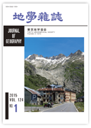
ジャーナル フリースイス南部に位置するローヌ氷河はアルプスのなかでも17世紀頃から急速に後退していることが知られている氷河である.この氷河は地中海にそそぐ全長 812 kmのローヌ川の源頭部に位置し,その全長は 10.2 km,面積 17.4 km2,体積1.9 km3(2012年)である.氷河の末端部は1602年にはホテル(標高 1,757 m)のあるすぐ近くに位置していたが,1900年には急崖直下の谷底まで後退し,2001年には標高 2,200 mの急崖上まで後退し,もはやグレッチュからは見えなくなった.
(写真・説明:小元久仁夫・大村 纂)抄録全体を表示PDF形式でダウンロード (970K)
総説
-
小河 正基2015 年 124 巻 1 号 p. 1-30
発行日: 2015/02/25
公開日: 2015/03/11
ジャーナル フリーGreat advances on observational studies of terrestrial planets including our own Earth since the 1990s suggest that we should fundamentally revise our view on the evolution of planetary interiors. It has been implicitly assumed that the mantle of a terrestrial planet evolves quasi-statically due to heat extraction by mantle convection. Tomographic studies on the Earth's mantle together with geologic studies, however, show that the overturn time of mantle convection is on the order of a billion years, which is comparable to the age of the Earth. So the evolution of the Earth's mantle is a dynamic process and the quasi-static model of mantle evolution is no longer tenable. Images of terrestrial planets recently sent from spacecraft suggest that the evolution of terrestrial planets depends systematically on their size, and that the evolution of the Earth should be understood in the context of this systematic relationship. The finding of super-Earths implies that we must figure a way to infer the evolution of these planets from limited information, such as the planetary mass, radius, and the composition of the atmosphere, on the basis of studies on terrestrial planets in our solar system. Geologic studies on Archean continents older than 2.5 billion years show that the tectonic regime of early Earth is qualitatively different from that of modern Earth, so the magmatism-mantle convection system in the Earth must have experienced a regime-transition at some point in its history. More dynamically oriented models of mantle evolution would be useful for predicting how the Earth's mantle evolved at its earliest stages on the basis of observations of other celestial bodies such as the Moon, where the old surface is still preserved. Further refinement of seismic studies on the Earth's interior combined with studies on the properties of mantle materials under high pressures are crucial to improve our understanding of the history of the Earth's interior.抄録全体を表示PDF形式でダウンロード (2917K)
論説
-
―多変量解析に基づく検討―尾方 隆幸2015 年 124 巻 1 号 p. 31-41
発行日: 2015/02/25
公開日: 2015/03/11
ジャーナル フリーGeoparks target all geoscientific multidisciplinary and interdisciplinary areas, whereas scientific topics of Japanese geoparks incline toward specific themes. Content analysis reveals that many geoparks attach greater importance to solid earth sciences (e.g. geology) and/or human geosciences (e.g. geography) than biogeosciences (e.g. paleontology), atmospheric and hydrospheric sciences (e.g. meteorology), and space and planetary sciences. Specialization coefficients clearly show this inclination, and suggest a shift from geological to geographical themes. Multivariate analyses also indicate several clusters of Japanese geoparks characterized mainly by geological and/or geographical contents. This specialization enumerates geological and/or geographical topics, and restricts a seamless geostory for interpreting a landscape. An educational program on the Ryukyu Islands focuses on various geomorphic processes related to the global environmental system. This program contributes to both an attractive and scientific geostory on interactions among atmosphere, hydrosphere, and geosphere. A seamless geostory using multidisciplinary and interdisciplinary approaches should be given more consideration in all Japanese geoparks, because it enhances a comprehensive outreach and education on geoscience.抄録全体を表示PDF形式でダウンロード (711K) -
磯野 巧2015 年 124 巻 1 号 p. 43-63
発行日: 2015/02/25
公開日: 2015/03/11
ジャーナル フリーThe nature guide activities have expanded in Oshima Town and cover various regional facets. Oshima Town has five nature guide organizations, in which nature guides have played various roles ever since they were established. Immediately after Mt. Mihara erupted in 1986, two organizations were set up to protect natural resources and explore the natural environment of the region. In the late 1990s, volunteer guide groups were organized to guide visitors. In addition, a paid guide organization, established in 2009, played a key role in offering interpreting services to tourists who joined guided tours. In 2010, Oshima Town was certified as a Japanese Geopark. Since then, paid guides have played important roles in interpreting the activities of the geopark to local people. Paid guides cooperate in geopark activities to complement the role played by nature guides. The various aspects of nature guide activities and the organizations in Oshima Town and their foundations can be summarized as follows: (1) A number of nature guide organizations have been created whose collective knowledge about the environment of Oshima Town serves as a strong foundation for their guide activities; (2) Paid guides in the geopark have developed multi-layered relationships with a focus on key guides; and (3) After Oshima Town was certified as a Japanese Geopark, paid guides have developed relationships with local residents. They are helping to construct a regional identity and rediscover the regional characteristics of Oshima Town.抄録全体を表示PDF形式でダウンロード (3550K) -
長井 雅史, 小林 哲夫2015 年 124 巻 1 号 p. 65-99
発行日: 2015/02/25
公開日: 2015/03/11
ジャーナル フリーIoto (Iwo-Jima; Sulphur Island) is a volcanic island located at the volcanic front of the Izu-Bonin arc about 1250 km south of Tokyo. The island consists of a central cone and southwest rim of a submarine caldera with a diameter of about 10 km. The rocks of the volcano are trachyandesite and trachyte, which are seldom found at a volcanic front. High rates of geothermal activity and crustal uplift have been observed, which are considered to be related to magma intruding at a shallow depth. Therefore, Ioto volcano is considered to be an active resurgent dome. However, eruptive history, including the process and timing of caldera formation, has not been clarified. Eruptive history based on our recent field survey, dating, and chemical analysis is as follows. A pre-caldera edifice was formed by volcanic activity of trachyandesite-trachyte magma in a subaerial and subaqueous environment. The magma composition and types of eruption were similar to those of the post-caldera edifice. It is still unclear when the caldera was formed. The caldera floor, which was a sedimentary basin with shallow marine sediments and a subaqueous lava flow, has been present at least since 2.7 cal kBP. Furthermore, a small volcanic island covered with trees used to exist in the Motoyama area. The complicated sequence of the Motoyama 2.7 cal kBP eruption is described as follows. First, on the volcanic island or in the surrounding shallow water, an explosive phreatomagmatic eruption occurred that formed subaqueous welded tuff (Hinodehama ignimbrite) and a subsequent thick subaqueous lava flow (Motoyama lava). While the Motoyama lava was still hot, the eastern part collapsed. The collapsed mass was quenched to form large blocks similar to pillow lava. A subsequent large phreatomagmatic eruption occurred, destroying the hot Motoyama lava, the older edifice, and the marine sediment. The resultant subaqueous pyroclastic flow generated the Motoyama pyroclastic deposit. Then, the eruption center shifted to the Suribachiyama area, which is just outside the southwest caldera rim. Deposits from three different eruption periods have been identified—lower, middle, and upper pyroclastic deposits—and a lava flow that erupted during the middle pyroclastic period. The lower unit was formed by a subaqueous eruption at a deeper level; the middle deposit was formed by a phreatomagmatic explosion at a shallow depth; and, the following lava emission generated a lava island. The upper pyroclastic deposit was generated by a combination of phreatomagmatic and Strombolian eruptions. Although the ages of these eruptions are not obvious, the first phase of the eruption occurred during the period between 2.7 cal kBP and 0.8-0.5 kBP, which is estimated from the age of the upper marine terrace X (Kaizuka et al., 1983). The eruption of the upper deposit occurred before AD 1779 (ca. 0.2 kBP). The eruptive products described so far are covered with younger sediment from marine terraces and spits. Recently, small-scale deposits from phreatic explosions accompanied by geothermal and uplift activities have been found distributed throughout the island, but juvenile material has not been confirmed to exist in the products.抄録全体を表示PDF形式でダウンロード (12132K) -
木村 治夫, 松浦 旅人, 林 泰幸, 市川 清士2015 年 124 巻 1 号 p. 101-126
発行日: 2015/02/25
公開日: 2015/03/11
ジャーナル フリーThe marine isotopic stage (MIS) 5e marine terrace, a paleo-sea-level indicator, is widely distributed at Cape Shiriyazaki, which is located at the northeastern end of Shimokita Peninsula, NE Japan. The elevation of the inner edge of the marine terrace indicates a relative uplift at the site during late Quaternary. However, the marine terrace surface in the study area is covered with colluvium, loess, and soil. Therefore, to reveal the 3-dimensional structure of horizons buried under cover sediments, ground penetrating radar (GPR) profiling was performed across and in parallel to the inner edge on the ground surface. The GPR survey area is about 100 m across the inner edge and about 200 m in parallel to the inner edge. Impulse GPR profiling was carried out along nine survey lines above a depth of about 5 m, and stepped frequency modulated continuous wave (FMCW) GPR profiling along nine lines above a depth of about 8 m. GPR data were collected with common-offset modes using the 350 MHz GPR system (Koden Electronics Co., Ltd) for impulse GPR profiling and the 5-160 MHz FMCW GPR system (Kawasaki Geological Engineering Co., Ltd) for FMCW GPR profiling. Furthermore, to estimate the electromagnetic wave velocity used for depth-conversion of GPR sections, the common mid-point (CMP) ensemble composed of 31 scan data was acquired at the site, located at the center of the survey area, with wide-angle measurements. As a result of geological interpretations of depth-converted GPR sections after careful data processing, we obtained the 2-dimensional structures of the boundary horizons between the loess and gravel bed, and the horizons between the gravel bed and bedrock on all GPR sections. We constructed 3-dimensional structures of horizons using these 2-dimensional structures. The form of the top of the gravel bed is similar to the ground surface with the exception of a few small areas. Although the top of the bedrock dips a little toward the present coast, the form is almost horizontal. The top of the bedrock probably shows a surface of an uplifted wave-cut platform. The elevations of inner edges inferred from the ground surface, the top of the gravel bed (the bottom of the loess), and the top of the bedrock (the surface of uplifted wave-cut platform) are 32–34 m, 30–32 m, 28–29 m, respectively.抄録全体を表示PDF形式でダウンロード (21219K)
寄書
-
―写真と資料による氷河の後退史―小元 久仁夫, 大村 纂2015 年 124 巻 1 号 p. 127-135
発行日: 2015/02/25
公開日: 2015/03/11
ジャーナル フリーThe Rhone Glacier is the best-documented case in the Alps of a rapidly retreating glacier. Photographs and other documents show the history of the changing glacier since the Little Ice Age. Fluctuations of the glacier tongue reflect decadal temperature fluctuations during the observation period. The last quarter century witnessed the most spectacular retreat, resulting in the development of a glacier lake. The pro-glacial lake has increased rapidly in size to the extent that the Swiss Federal Office of Cartography and Survey has given it the official geographical name of “Rhonesee”. The major stages of the Rhone Glacier are presented in this article with selected photographs and figures.抄録全体を表示PDF形式でダウンロード (1836K) -
佐藤 崇徳2015 年 124 巻 1 号 p. 137-146
発行日: 2015/02/25
公開日: 2015/03/11
ジャーナル フリーAlthough it is necessary to understand map projection to read a map of the world and view the world (surface of the Earth) accurately, geography teachers tend to avoid teaching map projection because they think it is both difficult to understand and to teach. Information technology provides more effective and attractive teaching methods and materials. Shadow images of the globe created by a light source are often used to explain map projection, but this method is not so effective. Transforming globe gores (polyconic projection gores) into various projections is better way to illustrate map projection. Computer software can be used to draw maps of the world using various projections, and to make digital images that illustrate map projections and the order of projections for teaching purposes. They can then be published as educational materials on the Internet. Web pages are constructed to teach the distortion inherent in a Mercator projection map with Google Maps API and Google Earth API. One of these Web pages shows users the great circle line and the rhumb line between any two points on Google Maps (Mercator projection) and Google Earth (digital globe). Another shows users equidistant circles and cardinal and inter-cardinal directions from any point on Google Maps and Google Earth. Teachers and students located anywhere can access the Web pages and study using these on-line materials.抄録全体を表示PDF形式でダウンロード (1526K)
口絵
-
長井 雅史, 小林 哲夫2015 年 124 巻 1 号 p. i-ii
発行日: 2015/02/25
公開日: 2015/03/11
ジャーナル フリーPDF形式でダウンロード (1750K) -
小元 久仁夫, 大村 纂2015 年 124 巻 1 号 p. iii-iv
発行日: 2015/02/25
公開日: 2015/03/11
ジャーナル フリーPDF形式でダウンロード (2058K) -
尾方 隆幸2015 年 124 巻 1 号 p. v
発行日: 2015/02/25
公開日: 2015/03/11
ジャーナル フリーPDF形式でダウンロード (1453K)
- |<
- <
- 1
- >
- >|