- 3 号 p. 143-
- 2 号 p. 63-
- 1 号 p. 1-
- |<
- <
- 1
- >
- >|
-
2024 年 133 巻 2 号 p. Cover02_01-Cover02_02
発行日: 2024/04/25
公開日: 2024/05/15
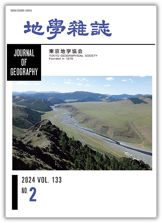
ジャーナル フリーモンゴルと聞くと広大な砂漠と緑の草原を思い浮かべる読者が多いかもしれない.しかしモンゴルは実に山の国である.同国中央部から北西部には植生を欠く赤茶けた山肌や急峻な山地が延々と連なり,なかには欧州アルプスを彷彿とさせる雪を被った峰が続く.モンゴル中央部のハンガイ(Khangai)山地(東西1000 km 南北200 km)には,おもに古生代の造山帯産物(付加体,花崗岩,高圧変成岩,オフィオライトなど)が産する.写真の地域はハンガイ山地西部を流れるオルホン川上流域(N46°50′ E101°45′)で,中央アジア造山帯の一部をなすデボン紀付加体が広く分布し,尾根にはしばしば硬い層状チャートが露出する.まだアジア大陸ができる以前に存在した広い海洋(古アジア海)底の欠けらであるチャートの尾根からは,植生や人工物がほとんどないため扇状地や網状河川などの自然地形がよく観察される.草原上の白い点に見える遊牧民達のゲルが,よいスケールである.対岸に広がる平坦な部分は一見河岸段丘面のように見えるが,実は第四紀に噴出した洪水玄武岩の流出面である.モンゴルを史上最大の帝国にまで仕立て上げたチンギスハンの物語として,古文書『元朝秘史』に基づく井上 靖著『蒼き狼』を読まれた読者も多いだろう.オルホン川はそのなかにたびたび出てきて,主人公のみならず,その兵士や家族が何度となくこの河を渡って長距離移動したことを思い起こさせる.1000年近くを経た今でもこの景観はその当時とそれほど変わっていないのではなかろうか.
(写真・説明:磯﨑行雄)
抄録全体を表示PDF形式でダウンロード (1832K)
-
松本 良, 蛭田 明宏, 大井 剛志, 柿崎 喜宏, 下野 貴也, 石田 直人, サイディ マッソウ, シュナイダ グレン, 戸丸 仁, 福 ...2024 年 133 巻 2 号 p. 63-89
発行日: 2024/04/25
公開日: 2024/05/15
ジャーナル フリーDue to the current energy crisis caused by global warming and geopolitical events, evaluating the energy potential of marine gas hydrates around the Japan Islands has become an urgent issue. Based on open and public reports, a critical overview is provided of the current status of the exploration of gas hydrates in the eastern Nankai Trough and along the eastern margin of the Japan Sea. In 2001, an exploration and resource assessment of gas hydrates in the eastern Nankai Trough was launched as a national project. In the late 20th century, hydrate-induced BSRs had been widely recognized on the fore-arc basins and slopes of the accretionary wedges of the Nankai Trough. Integrated geological and geophysical exploration reveals that the hydrates of the eastern Nankai Trough occur in the interstitial pore space of sand layers (pore filling type) of the Early Pleistocene turbidite units of 100 to 200 m in thickness above the BSR-BGHS. Hydrate exploration in the Japan Sea entered the National project in 2012, following academic efforts over the preceding 10 years, confirming 1,742 columnar-shaped gas chimney structures (generally a few hundred meters across and roughly 100 m deep) in which a few centimeters to nearly 50 m of thick massive hydrate deposits occur in the Middle Pleistocene silty host sediments. Japan Sea hydrates are considered to have grown in the host sediments, displacing clayey particles (particle displacement type). Gas chimney structures are the main conduits for the migration of deep-seated methane, associated with sea floor methane seeps, chemosynthetic communities, and methane-derived authigenic carbonates. A high concentration of massive hydrate is related to enhanced maturation and accumulation of hydrocarbon deposits under the high heat flow of the Japan Sea basin. Additionally, glacial eustasy of the closed Japan Sea basin facilitated efficient recycling of methane to accumulate massive hydrates.
抄録全体を表示PDF形式でダウンロード (7893K)
-
─火山活動監視の視点から─原田 昌武, 吉田 明夫2024 年 133 巻 2 号 p. 91-100
発行日: 2024/04/25
公開日: 2024/05/15
ジャーナル フリーThe most serious situation from the viewpoint of disaster prevention in activity at Hakone volcano is a burst of volcanic gases and hot steam, as observed in 2001 and 2015. Using GNSS data and based on Mogi's model, it is found that the pressure sources of activity in 2001 and 2015 are relatively shallow compared to other sources of volcanic activity. Whether a pressure source is relatively shallow or not can be easily distinguished by noting changes in distance between GNSS observation sites at Odawara and Hakone. If the distance decreases, the pressure source is considered to be shallow. The extent of volcanic activity differs each time and only two cases of recent activity are known where dangerous surface phenomena are observed. Therefore, it cannot be said that volcanic activity with a shallow pressure source would always be hazardous and activity with a relatively deep source would not become dangerous. However, making use of empirical knowledge, it is believed to be meaningful to monitor volcanic activity more carefully when the pressure source is estimated to be relatively shallow.
抄録全体を表示PDF形式でダウンロード (3813K) -
─星山丘陵多測線統合的地震探査の成果─伊藤 谷生, 狩野 謙一, 佐藤 剛, 藤原 明, 渡辺 俊樹, 東中 基倫, 阿部 進, 阿部 信太郎, 津村 紀子, 山本 玄珠, 佐藤 ...2024 年 133 巻 2 号 p. 101-128
発行日: 2024/04/25
公開日: 2024/05/15
ジャーナル フリー
電子付録The Fujikawa-kako fault zone (FKFZ) is one of the most active fault zones constituting the northwest border of the Izu collision zone between the Honshu and Izu arcs. Its vertical slip rate is estimated to reach 6 to 7 m/ky along the eastern margin of FKFZ. In order to elucidate the causes of such high fault activities, the structure of this fault zone from the seismogenic zone to the surface is revealed. An integrated seismic exploration, which links several seismic exploration techniques, is employed. Thus, a two-stage integrated seismic exploration is designed and carried out. The first stage, named FIST2012, aims to reveal the shallow to deep structures of the upper surface of the Philippine Sea Plate (PHS), FKFZ and Itoigawa-Shizuoka Tectonic Line (Fujiwara et al., 2024). The second stage, named Multi-line Hoshiyama 2015 attempts to elucidate the three-dimensional structure of the Omiya fault (Omy) and the Iriyamase fault (Irs) from the seismogenic zone to the surface, both of which form the eastern margin of FKFZ. The main purpose is to present the outcomes of the second stage, and to discuss any remaining problems. The results are as follows. Omy consists of the Sole thrust (St) and the Roof thrust (Rt), which together form a N30°W trending wedge-thrust structure, whereas Irs mainly consists of two segments: N50°E-trending Fa and N48°E-trending Fd. Fa originates from St of Omy as a reverse fault. On the other hand, Fd plays a role in a tear fault of St. The three-dimensional structure of Omy and Irs shows that both faults form a single active fault system driven by the thrust motion of St, which connects with the branching fault from the upper surface of PHS. This means that the high fault activities of FKFZ directly reflect the motion of PHS. Although the outcomes are significant, major problems remain. Firstly, ages cannot be assigned to depth sections due to the lack of geological and geophysical data from boreholes, with the exception of two shallow boreholes. This prevents precise interpretations of depth sections from being completed. Thus, geological and geophysical data from boreholes are urgently needed. Secondly, the N60E-trending thrust motion on N30W-trending St seems to contradict the NW-trending PHS motion relative to the Honshu arc, even though St connects with the branching fault that originates from the upper surface of PHS. The structural relationship between the two motions between St and PHS is still unresolved. To address this issue, the three-dimensional geometry of the upper surface of PHS where the branching fault originates needs to be understood.
抄録全体を表示PDF形式でダウンロード (12351K)
-
─阿蘇の風物詩「野焼き」に注目して─鈴木 健介, 齋藤 仁, 松山 洋2024 年 133 巻 2 号 p. 129-141
発行日: 2024/04/25
公開日: 2024/05/15
ジャーナル フリー
電子付録Precipitation events from March 1 to 7 are analyzed in the Aso region, central Kyushu, based on local traditional event known as “Noyaki” (controlled burning), held on the first Sunday of March, which has been postponed in recent years. During the period 2002-2009, precipitation was not observed on the first Sunday of March at the Aso-Otohime Station of the Automated Meteorological Data Acquisition System (AMeDAS), whereas it was frequently observed during the period 2010-2021. The number of rainy days from March 1 to 7 at AMeDAS stations throughout Kyushu during the period 2010-2021 was greater overall than that during the period 2002-2009, with a statistically significant increase confirmed at eight stations located in the eastern–southeastern part of Kyushu. Precipitation from March 1 to 7 increased throughout Kyushu, with the exception of the northern part during the period 2010-2021, whereas the intensity of precipitation did not show any statistically significant change at the AMeDAS stations as a whole. Therefore, it is considered that the increase in rainy days is responsible for the frequently observed rainfall and the increase in precipitation around the Aso region during the period 2010-2021. From the run test, it is concluded that there will be regularity in the series of the presence/absence of precipitation at AMeDAS Aso-Otohime Station in the future, whether or not there is precipitation on the first Sunday of March. When precipitation persists, regularity emerges, suggesting a long-term increasing trend in the increase of precipitation events, while the absence of precipitation suggests that the recent increase in precipitation events is a component of cyclical variations.
抄録全体を表示PDF形式でダウンロード (1857K)
- |<
- <
- 1
- >
- >|