- 6 号 p. 745-
- 5 号 p. 591-
- 4 号 p. 443-
- 3 号 p. 315-
- 2 号 p. 149-
- 1 号 p. 1-
- |<
- <
- 1
- >
- >|
-
2020 年129 巻5 号 p. Cover05_01-Cover05_02
発行日: 2020/10/25
公開日: 2020/11/13
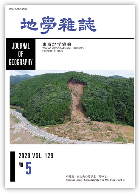
ジャーナル フリー2020年7月3日から4日に記録的な豪雨に見舞われた熊本県南部の芦北町と津奈木町では多数の斜面災害や浸水被害等が発生し,14名の貴重な人命が奪われた.今回の斜面災害はジュラ紀の付加体が分布する地域を中心に起こっており,土石流に移行したものとそうでないものが認められた.いずれのタイプの崩壊も厚い風化土層内で発生したものであり,深さが20 m程度に達するものはあるが,岩盤が大きく破壊されるような深層崩壊ではなかった.写真は芦北町宮浦(みやのうら)地区の傾斜30°程度の浅い凹型の林地斜面で起こった高さ70 m,幅40 m程度の崩壊を撮影したものである.滑落崖には赤褐色の厚い風化土層が見え,崩壊下部の狭窄部では断層破砕帯も観察された.この崩壊では多量の土砂と流木が発生したが,その流下堆積域に住宅などの建物がなかったため,人的被害は出ていない.
(写真・解説:宮縁育夫 2020年7月12日撮影)
抄録全体を表示PDF形式でダウンロード (2572K)
-
菅沼 悠介, 石輪 健樹, 川又 基人, 奥野 淳一, 香月 興太, 板木 拓也, 関 宰, 金田 平太郎, 松井 浩紀, 羽田 裕貴, 藤 ...2020 年129 巻5 号 p. 591-610
発行日: 2020/10/25
公開日: 2020/11/13
ジャーナル フリーThe Antarctic Ice Sheet (AIS) is one of the largest potential contributors to future sea-level changes. Recently, an acceleration of AIS volume loss through basal melting and iceberg calving has been reported based on several studies using satellite observations, including radar altimetry, interferometer, and gravity measurements. A recent model that couples ice sheet and climate dynamics and incorporates hydrofracturing mechanism of buttressing ice shelves predicts a higher sea-level rise scenario for the next 500 years. However, the calibration and reproducibility of the sea-level rise projection from these models relies on geological sea-level reconstructions of past warm intervals. This suggests that a highly reliable reconstruction of the past AIS is essential for evaluating its stability and anticipating its contribution to future sea-level rise. In particular, a relative sea-level reconstruction in East Antarctica is the key to solving the problems and refining future projections. The current understanding of sea-level change along the East Antarctic margin is reviewed, including Glacial Isostatic Adjustment (GIA) effects, and a new strategy is proposed to address this topic based on seamless sediment coring from marine to lake in the East Antarctic margin. This project will provide essential data on AIS change since the last interglacial period.
抄録全体を表示PDF形式でダウンロード (4547K)
-
─迷信と科学的思考─遠藤 匡俊2020 年129 巻5 号 p. 611-634
発行日: 2020/10/25
公開日: 2020/11/13
ジャーナル フリーNatural phenomena such as volcanic eruptions, earthquakes, and tsunami, have long been regarded by many people around the world as indicating the wills of deities. Such superstitions have been replaced gradually by modern scientific thinking. The Ainu people believed that evil deities caused volcanic eruptions, so they prayed to benevolent deities in order to avert them. As such, the Ainu people had superstitious beliefs on the causes of volcanic eruptions and how they could be prevented. In spite of their superstitious beliefs, the Ainu people actually had scientifically accurate ideas on the process of a volcanic eruption, the origins of material ejected from a crater, and the process of lava dome formation. This was long before scientific conception of volcanology and the geomorphology of volcanoes emerged in Japan. Modern science was introduced to Japanese volcanology and the geomorphology of volcanoes in the 1890s. Around the 1791, the Ainu people, who were neither scientists nor specialists, surmised that a volcanic eruption was actually caused by burning material under ground rising up from a crater through a fire well to the surface. The Ainu people's deductions on the process of a volcanic eruption were similar to the latest theories on magma eruptions in volcanology. The Ainu people's course of action of seeking refuge when Mt. Usu erupted was not based on superstition but on their memories of past eruptions. These memories informed them that a series of earthquakes heralded an eruption, as well as the facts that damage to areas by eruptions and their personal sufferings were actually due to pyroclastic flows and surges from past eruptions of Mt. Usu.
抄録全体を表示PDF形式でダウンロード (2503K) -
─山梨県山中湖村平野地区を事例に─渡邊 瑛季2020 年129 巻5 号 p. 635-655
発行日: 2020/10/25
公開日: 2020/11/13
ジャーナル フリーThe sustainability of sports training camps is studied in terms of accommodation–team–travel agent relationships in Hirano District, Yamanakako Village, Yamanashi Prefecture. Relationships among the abovementioned three factors involved in sports training camps in Hirano are analyzed using reservation methods, which are divided into two types: reservations through travel agents and direct reservations with accommodation facilities in Hirano. Intermediaries are divided into two types: travel agents with links to sports training camps and those with links to teachers handling school club activities. Historically, travel agents have been important intermediaries in Hirano: in the 1950s, a young man managing accommodation for those coming to Hirano for fishing established travel agents in Tokyo in order to attract teams to a tennis training camp, leading to the development of Hirano as a tennis training camp area. Regional conditions in Hirano, geographical accessibility to the Tokyo metropolitan area, cool summer climate, and accommodation and sports training facilities all contribute to attracting sports teams for a first-time visit. At the same time, travel agents in Tokyo play an important role in attracting not only new guests but also repeat visitors. Thus, trust and cooperation between travel agents and accommodation facilities or teams is of critical importance. Repeat visits through travel agents are based on interdependence and cooperation between accommodation facilities and travel agents for regular visits by teams, as well as trust between travel agents and teams based on the travel agents' sales methods. On the other hand, repeat visits with direct reservations are seen to be based on cooperation between teams and accommodation facilities to facilitate adjustments before training camps are held. In conclusion, there is a strong sense of interdependence, trust, and cooperation among accommodation facilities, sports teams, and travel agents in the Hirano district. These relationships can be explained not only from the viewpoint of business economics but also in terms of their reciprocal nature, which contributes to the sustainability of sports camps.
抄録全体を表示PDF形式でダウンロード (3504K)
-
Masaya YASUHARA, Takeshi HAYASHI, Kazuyoshi ASAI, Mieko UCHIYAMA, Taka ...2020 年129 巻5 号 p. 657-660
発行日: 2020/10/25
公開日: 2020/11/13
ジャーナル フリーPDF形式でダウンロード (61K) -
安原 正也, 林 武司, 浅井 和由, 内山 美恵子, 中村 高志2020 年129 巻5 号 p. 661-664
発行日: 2020/10/25
公開日: 2020/11/13
ジャーナル フリーPDF形式でダウンロード (276K)
-
山本 真也, 中村 高志, 芹澤 如比古, 中村 誠司, 安田 泰輔, 内山 高2020 年129 巻5 号 p. 665-676
発行日: 2020/10/25
公開日: 2020/11/13
ジャーナル フリーLake bottom springs play an important role in maintaining water quality in the Fuji Five Lakes. However, the sources of these springs and the hydrological delivery mechanisms have yet to be identified. To determine the sources of spring water of Lake Kawaguchi, samples were collected directly from lake bottom springs, and oxygen and hydrogen stable isotope ratios were obtained, along with vanadium concentrations. Visual observations and water-quality analyses of the samples reveal that cold and oxygen-rich water is discharged from the lake floor, which is covered by gravel with diameters of 10-50 cm over an area of approximately 9 m (east–west) by about 13 m (north–south). The water temperature of the springs remained relatively constant at around 11.3°C during the stratified period in 2016; however, the temperature fluctuated significantly in 2017, even during the stratified period, suggesting a temporary decrease or stoppage of water being discharged from springs into the lake. Oxygen and hydrogen stable isotopic ratios of lake bottom springs were determined to be higher than those of groundwater in the southern part of Lake Kawaguchi; however, they displayed values close to those of groundwater in the northern part of Lake Kawaguchi, suggesting that spring water primarily originated from groundwater in the Misaka Mountains.
抄録全体を表示PDF形式でダウンロード (1830K) -
林 武司2020 年129 巻5 号 p. 677-695
発行日: 2020/10/25
公開日: 2020/11/13
ジャーナル フリーMt. Fuji, the highest stratovolcano in Japan, has been considered to be a huge water reservoir. Various studies on the water environment of Mt. Fuji have been carried out to understand its scientific characteristics, and for water resource development. However, the mechanism of the water cycle, especially the groundwater flow system in this area, has still not been clarified. The hydrogeological settings and the groundwater flow at the northern part of Mt. Fuji are discussed based on the results of previous studies. Moreover, current issues and prospects are pointed out to further understand the hydrology of this area. Considering the hydraulic conductivities of the layers (e.g. volcanic sand and gravel, lava, volcanic mudflow) of the Shin-Fuji (Younger Fuji) stage and the Ko-Fuji (Older Fuji) stage, it is possible for groundwater to flow in the layers of both stages. At the northwestern foot of Mt. Fuji, three lakes (Lakes Sai, Shoji, Motosu) are mainly recharged not by Mt. Fuji but by the surrounding mountain area. Groundwater at the northwestern foot of Mt. Fuji is considered to be recharged by both water recharged in the northwestern flank of Mt. Fuji and water seepages from these lakes, and to flow toward the western-southwestern foot of Mt. Fuji. To further understand the water cycle in Mt. Fuji, it is essential to comprehensively discuss the results of various studies such as those on the geology, volcanology, geophysics, geochemistry, climatology, and hydrology of Mt. Fuji based on the viewpoints of hydrology and hydrogeology.
抄録全体を表示PDF形式でダウンロード (1581K) -
内山 高2020 年129 巻5 号 p. 697-724
発行日: 2020/10/25
公開日: 2020/11/13
ジャーナル フリーQuaternary volcanoes and their surrounding terrains typically have excellent water resources and generally are more abundant in groundwater than other areas, because aquifers consist of very permeable volcanic materials, such as lava flows and fall deposits. However, the groundwater-flow systems and storage processes are complex, due to the geological setting and volcanic histories. Fuji Volcano is the most famous Quaternary volcano in Japan, and is one of the most active. Volcanic activity at Fuji Volcano began about 100,000 years ago. Fuji Five Lakes (Fuji-Goko), consisting of Lake Motosu, Lake Shoji, Lake Sai, Lake Kawaguchi and Lake Yamanaka, lying in the northern foot area, were dammed by pyroclastic flows from Fuji Volcano. The groundwater-flow system at the northern foot area of Fuji Volcano is summarized based on the results of previous hydrogeological research and joint research on the groundwater-flow system and volcanic geology. The results of aquifer unit classification and hydrogeological characterization at the northern foot of Mt. Fuji are summarized as follows with the aquifer unit classified into five divisions. The aquifers are subdivided into Saq-1 and 2, Faq-1 and 2, and Haq-2 in descending order of depth. Haq-1 is a volcanic mudflow deposit that was formerly known as the Old Fuji Mudflow, and is considered an impervious layer. The timing of the formation of Fuji Five Lakes is as follows: Lake Yamanaka has two formation times, about 5 ka and 1.4 ka. Lake Kawaguchi was dammed up about 20 ka and took almost its present shape in 10 ka. Lake Motosu was prototyped in 30 ka and remains to the present day. In the process, the “Lake Se (Se no Umi)” was formed, and about 1,200 years ago, the Jogan eruption divided Se no Umi into Lake Sai and Lake Shoji. This timeline was confirmed by observations of the groundwater level, indicating that the water flows out from Lake Kawaguchi to the south through lava flow Faq-1 and 2.
抄録全体を表示PDF形式でダウンロード (17106K) -
鹿園 直建, 大友 一夫, 浅井 和由, 中田 正隆2020 年129 巻5 号 p. 725-743
発行日: 2020/10/25
公開日: 2020/11/13
ジャーナル フリーRelationships of concentrations of elements (Ca, Mg, Si) in groundwater from the Mt. Fuji area are obtained using analytical data on groundwater. Relationships of Ca, Mg, and H4SiO4 concentrations can be explained in terms of the dissolution of basaltic glass and precipitations of secondary minerals (halloysite, allophane, montmorillonite, and α-cristobalite). The relationship between residence time and H4SiO4 concentration of groundwater is obtained based on dissolution kinetics-piston fluid flow and a perfectly mixing fluid flow model. Using this relationship, the dissolution rate constant experimentally determined in an open system (not in a closed system) (k = 10−10.7 molSi/m2 s) and analytical data on H4SiO4 in groundwater, the residence time of groundwater (Kakitagawa site, southeastern foot and Fuji Yoshida site, northern foot) is estimated to be ca. 20 years for A/M (A: surface area of rock (m2), M: mass of water (kg)) = 20 based on a dissolution kinetics-fluid flow model. This estimated residence time is roughly consistent with other methods (He isotope tritium, chlorofluorocarbons (CFCs) ages (10-40 years), indicating that the dissolution kinetics-fluid flow model using dissolved silica concentration is a potentially useful method for estimating the residence time of groundwater in a young volcanic region. It is also reported that CFCs ages are ca. 30-40 years, which are the first data obtained for the Mt. Fuji area. This suggests that CFCs data are very useful for providing the residence time of groundwater in an area at a high elevation.
抄録全体を表示PDF形式でダウンロード (2268K)
- |<
- <
- 1
- >
- >|