- 6 号 p. 745-
- 5 号 p. 591-
- 4 号 p. 443-
- 3 号 p. 315-
- 2 号 p. 149-
- 1 号 p. 1-
- |<
- <
- 1
- >
- >|
-
2020 年 129 巻 3 号 p. Cover03_01-Cover03_02
発行日: 2020/06/25
公開日: 2020/07/11
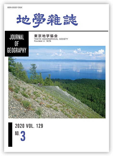
ジャーナル フリーモンゴル中央部の最北縁,ロシアとの国境に近い標高1645 mの高原に,南北に伸びたフブスグル湖(Lake Khubsugul)は位置する.南北に約140 km,東西に約35 kmのサイズ(モンゴル第2位)をもつ淡水湖で,最大水深は262 mに及ぶ.「青い水」に由来するその名前の通り,透明度の高さで知られる.標高ならびに緯度の高さゆえに,冬季には完全氷結する厳しい環境になり,かつてはトナカイの放牧などが行われるのみだったが,近年では夏期の行楽地として賑わうようになり,さらに冬季スポーツが流行しはじめている.8月中頃でも,写真撮影した快晴の翌朝にはブリザードに悩まされた.まれではあるが,雪豹の目撃談も頷ける.
東北東約200 kmのシベリア南部には,はるかに大きなバイカル湖がある.ともにほぼ南北に伸びるこれら2つの湖は,新生代後半のアジア中央部地殻に展張応力場が生じ,リフト化してできた湖である.フブスグル湖の形成は新第三紀末から第四紀はじめだったとされるが,未解明なことが多い.西側には3000 m級の尾根をもつ急峻な山岳がそびえ,夏期でも雪を蓄えるその山容は欧州アルプスの景観に近い.先カンブリア時代原生代末から古生代カンブリア紀初期の堆積岩およびそれらに貫入した古生代花崗岩類などが露出する.これら岩石は,古生代に複数の大陸塊(シベリア,中国北半分,タリムなど)がそれらの間に存在した海洋を壊しながら衝突・合体して,アジアの中核を形成した歴史(中央アジア造山帯の形成史)を記録している.
(写真・説明:磯﨑行雄)
抄録全体を表示PDF形式でダウンロード (2529K)
-
川又 基人, 菅沼 悠介, 土井 浩一郎, 澤柿 教伸, 服部 晃久2020 年 129 巻 3 号 p. 315-336
発行日: 2020/06/25
公開日: 2020/07/11
ジャーナル フリーThe purpose of geomorphological studies in East Antarctica is to understand past fluctuations of the Antarctic Ice Sheet, which is essential to constrain ice sheet models and predict future behavior of the East Antarctic Ice Sheet. Here we show a deglacial history of Skarvsnes, at the southern part of the Soya Coast, East Antarctica based on a geomorphological field survey and newly obtained surface exposure ages. Bedrock higher than ca. 250 m a.s.l. at the northwest part of Skarvsnes (Skjegget) is weathered extensively, whereas bedrock below ca. 250 m a.s.l. is relatively unweathered. The degree of weathering of bedrock above 250 m a.s.l. is similar to that at the northern part of the Soya Coast, which is thought to have been ice-free throughout the last glacial period. Therefore, a clear difference in the degree of weathering depending on altitude probably indicates the lower limit of the ice sheet elevation during the last glacial period at Skarvsnes. Judging from the multiple directions of glacial striae, the ice sheet covering the area retreated while changing flow direction under the influence of the bedrock topography after the last glacial period. Since ca. 9 ka, the ice sheet is thought to have thinned and eventually divided into two major ice streams (northward and southward) that were obstructed by a 362 m a.s.l. mountain (Shirasuso-Yama), at the southeastern part of Skarvsnes. However, the timing of the initiation of the ice sheet retreat and its duration remain unclear. Therefore, additional surface exposure ages from various areas and heights at Skarvsnes are required for a detailed reconstruction of the ice retreat history and to understand its mechanism.
抄録全体を表示PDF形式でダウンロード (5089K) -
吉田 幸平, 高木 秀雄2020 年 129 巻 3 号 p. 337-354
発行日: 2020/06/25
公開日: 2020/07/11
ジャーナル フリーScience subjects at Japanese high schools are divided into physics, chemistry, biology, and Earth science. The numbers of credits set are two for basic subjects and four for advanced subjects. With a change of courses based on new guidelines enforced by the Ministry of Education, Culture, Sports, Science and Technology Japan (MEXT) in 2012, the Earth science field has classes in Basic Earth Science and Advanced Earth Science. The percentage of high school students who take Earth science classes is estimated from the number of textbooks adopted by MEXT (26% for Basic Earth Science and 1.2-0.9% for Advanced Earth Science), but the percentages of high schools that offer Earth science classes in each prefecture have not been reported. Therefore, the proportion of high schools that offer Basic Earth Science and Advanced Earth Science classes are estimated based on a survey of more than 5,000 high schools in Japan. Data for the survey were collected from the curriculum listed on each high-school homepage and from a questionnaire distributed using the Google mail system. Survey results indicate that 43.7% of high schools nationwide offer Basic Earth Science, and only 8.8% of high schools offer Advanced Earth Science. In addition, the proportion of high schools offering Earth science classes varies depending on the prefecture. The highest proportion of high schools offering Basic Earth Science is 71% (Okinawa) and the lowest is only 4% (Miyazaki). The top prefectural percentage for Advanced Earth Science is 48%, but nine prefectures have no high schools offering Advanced Earth Science. The proportion of high schools offering Earth science correlates with the number of Earth science teachers employed over the past 40 years in each prefecture. However, some prefectures have records only for the total number of science teachers; therefore, the numbers of teachers hired specifically to teach Earth science are not known in these cases. The percentages of high schools offering Earth science classes are higher in prefectures for which only the total number of science teachers is known. A draft is provided on promoting Earth science education at high schools comparing differences among prefectures in the percentages of high schools offering Earth science classes. Based on our results, to promote high school geoscience education, support should be provided through workshops on Earth science education, so that science teachers other than full-time Earth science teachers can recognize the importance of Earth science and teach Basic Earth Science.
抄録全体を表示PDF形式でダウンロード (2236K) -
宇都宮 正志, 水野 清秀, 納谷 友規, 小村 健太朗, 長井 雅史2020 年 129 巻 3 号 p. 355-374
発行日: 2020/06/25
公開日: 2020/07/11
ジャーナル フリーA tephra bed named CB2038 was found at a depth of 2038.26-2038.21 m in a boring core sample (hereafter called Chiba core) drilled at Chiba City, east of Tokyo Bay. The calcareous nannofossil assemblage from CB2038-bearing siltstone is characterized by the presence of small (< 3 μm) gephyrocapsids and Calcidiscus macintyrei, and the absence of discoasters, suggesting that CB2038-bearing strata correspond to the Ohara to the lower Kiwada formations (lower Pleistocene) exposed on the Boso Peninsula. Possible candidates to be correlative with CB2038 are Oh16A, B in the Ohara Formation, and Kd48.2, Kd48.1, Kd48, and Kd40 in the lowermost Kiwada Formation, because of the similarity of the shapes of glass shards and heavy mineral composition (hornblende > orthopyroxene). Among these tephra beds, Kd48 was considered the best candidate to be correlative with CB2038 based on refractive index, and major and trace element compositions of glass shards. Kd48 identified from deep underground near Tokyo Bay would make a significant contribution to the subsurface stratigraphy of basement strata around the Tokyo metropolitan area.
抄録全体を表示PDF形式でダウンロード (5753K) -
丸山 誠史, 山下 透, 林田 明, 平田 岳史, 檀原 徹2020 年 129 巻 3 号 p. 375-396
発行日: 2020/06/25
公開日: 2020/07/11
ジャーナル フリー中国地方および近畿地方で見いだされている阪手テフラは,三瓶火山より噴出した三瓶浮布テフラ(SUk)に対比されている。SUkテフラは,三瓶山近傍の露頭観察より,下位から浮布降下軽石堆積物(Uk-pfa),緑ヶ丘火砕流堆積物(Md-fl),浮布降下火山灰堆積物(Uk-fa)に分けられている。これまでの研究では,阪手テフラはMd-flに対比されている。Md-fl(阪手)試料に含まれる角閃石の屈折率は,Uk-pfa試料に含まれるものと似通っていた。それに対して,Md-fl(阪手)試料に含まれる火山ガラスの屈折率は,Uk-pfa試料に含まれるものより低かった。またUk-faの岩石学的特性から判断すると,Uk-faとMd-flは一つの同じテフラとみなすことが可能だった。Uk-pfaに含まれる火山ガラスのSiO2濃度は,ガラス屈折率からの予測に反して,Md-flのものよりも高かった。しかしながら,Uk-pfaに含まれる火山ガラスのFeO濃度は,Md-flのものに比べて明らかに高かった。このことからガラス屈折率の差異は,SiO2濃度ではなくFeO濃度の違いによるものと推定された。火山ガラスに含まれる合計58元素の濃度パターンは,全体としてはMd-flとUk-pfaの間で非常に似通っているものの,軽希土類元素などの部分で明らかに区別が可能だった。こうした元素組成の違いは結晶分化の過程で起こったか,あるいは他のマグマ源からの混入による,マグマの化学組成の変化によるものと推定された。これまでの研究をみると,Md-fl/Uk-fa(阪手)テフラに対比されるテフラは,中国地方および近畿地方に広く分布していた。一方,Uk-pfaテフラに対比されるテフラは,近畿地方南部およびその近海,そして四国東端で見いだされていた。Uk-pfaとMd-fl/Uk-faは一連の噴火活動で噴出したものと考えられるが,テフラの分布域も明確に区別可能であることが判明した。本研究の結果から,Uk-pfaとMd-fl/Uk-faテフラはそれぞれ,SUk(lower)(下部)およびSUk(upper)(上部)テフラと,より単純なものに再定義可能である。
抄録全体を表示PDF形式でダウンロード (4219K) -
─砕屑性ジルコンのU–Pb年代測定─長谷川 遼, 磯﨑 行雄, 山本 純之, 堤 之恭2020 年 129 巻 3 号 p. 397-421
発行日: 2020/06/25
公開日: 2020/07/11
ジャーナル フリー
電子付録To reconstruct the tectono-sedimentary history of the Cretaceous fore-arc in Japan, U–Pb dating is conducted of detrital zircons in Upper Jurassic and Cretaceous shallow-marine sandstones from the Chichibu belt in Kyushu, Shikoku, and Kii Peninsula, Southwest Japan. The U–Pb ages of detrital zircon in 18 analyzed sandstone samples revealed the following new facts. The predominance of Jurassic grains, with a minor amount of Paleozoic and Precambrian grains, in the Upper Jurassic and pre-Hauterivian Lower Cretaceous sandstones indicates that the fore-arc has been fed with abundant terrigenous clastics from the provenance composed of the Jurassic arc granitoids/accretionary complexes. More Permian grains were supplied probably from the older Permian accretionary complex in a limited way during the Hauterivian, nonetheless, Jurassic grains again dominated in the Aptian sandstones. In contrast, Albian and Upper Cretaceous sandstones are characterized by the remarkable predominance of Cretaceous zircons with almost a complete absence in pre-Cretaceous zircons. This suggests a major reorganization of the arc provenance in the mid-Cretaceous, probably during the Albian; i.e., from the previous regime with dominant Jurassic orogenic elements to a new one solely with Cretaceous arc granitoids. Coeval sandstones in Kanto share the same age spectra and secular changes, indicating not only the monotonous nature of the provenance and fore-arc basin for nearly 1000 km along arc-trench system, but also the appearance of regional tectonism in mid-Cretaceous SW Japan. In particular, the total shut-down of pre-Cretaceous grains into the fore-arc domain probably reflects the appearance of a significant/effective topographic barrier in the arc crust with respect to mid-Cretaceous extensive arc magmatism along the active margin in East Asia, prior to the opening of the Japan Sea in the Paleogene–Miocene.
抄録全体を表示PDF形式でダウンロード (5987K)
-
中岡 裕章2020 年 129 巻 3 号 p. 423-442
発行日: 2020/06/25
公開日: 2020/07/11
ジャーナル フリーThe significance of developing tourist destinations by promoting ecotourism in areas around Tanigawadake in Minakami, Gunma prefecture, Japan, are studied, along with related issues. The aim is to understand the rationale for introducing ecotourism, the reasons why it should be encouraged, and why tourists enjoy ecotourism. The town of Minakami has witnessed a decline in its tourism industry with a decrease in the number of tourists visiting hot springs and ski grounds. Meanwhile, a large concentration of tourists visits the area surrounding Tanigawadake for hiking and trekking. This imbalance is a cause for concern because it can adversely affect the natural environment. To address this, ecotourism has been introduced in the area around Tanigawadake in an attempt to balance environmental conservation with regional development. Ecotours have also been conducted by the Minakami Mountain Guide Association. As a result of the spread of information about the environment, awareness of environmental conservation can be seen in and around the area. It is also observed that tourism workers get a sense of satisfaction from exchanges with tourists and receive income. At the same time, these workers have different expectations about what should be achieved through ecotourism and the role it should play. In particular, a number of workers participating in ecotourism in this area also work in Minakami's tourism industry. They tend to believe that rebuilding the tourism industry in the town is imperative for its growth. However, because the scope of ecotourism was limited to the area around Tanigawadake, efforts focused on this region, limiting the expansion of tourism in Minakami. This was in contrast to the expectations of the workers. Besides, ecotours are positioned as niche travel products. To address this gap, it is important to achieve a balance between tourism and ecotourism by reconsidering local policies and practices, with due consideration given to the actual circumstances of the local tourism industry and the interests of tourism professionals.
抄録全体を表示PDF形式でダウンロード (1704K)
- |<
- <
- 1
- >
- >|