- 6 号 p. 665-
- 5 号 p. 533-
- 4 号 p. 407-
- 3 号 p. 263-
- 2 号 p. 105-
- 1 号 p. 1-
- |<
- <
- 1
- >
- >|
-
2017 年 126 巻 6 号 p. Cover06_01-Cover06_02
発行日: 2017/12/25
公開日: 2018/01/24
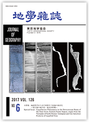
ジャーナル フリー液状化コアの3次元CT画像解析の例
A:2011年東日本大震災で噴砂が確認された地点で採取したコアの半裁写真.複雑に曲がった砂脈がかろうじて確認できる.縦の長さは23 cm.
B:半裁コアから切り出したスラブの軟X線写真.スラブの厚さが10 mmもあるので,砂脈の輪郭は不明瞭である.
C:半裁する前に撮影した2次元X線CT画像.A,Bと違って,砂脈が明瞭にみえる点に注目.
D:GrowCutアルゴリズムをCにほどこして,砂脈だけを抽出した結果.GrowCutアルゴリズムについては,本編の小特集で解説されている.
E:Dと同様に抽出した209枚の2次元画像を積層して3次元的にみせたもの.砂脈が複雑に折れ曲がり,また分岐している様子が確認できる.
A-C,EはNakashima and Komatsubara (2016) を改変.
(中島善人)
抄録全体を表示PDF形式でダウンロード (1352K)
-
笠原 天生, 鈴木 毅彦, 河合 貴之, 今泉 俊文2017 年 126 巻 6 号 p. 665-684
発行日: 2017/12/25
公開日: 2018/01/24
ジャーナル フリーRecent advance of Quaternary tephra studies in Northeast Japan enables us to reconstruct depositional histories in inland basins back to Middle to Early Pleistocene. The Koriyama Basin located in the southern part of the Northeast Japan arc is filled with the Koriyama Formation (KF) forming dissected Koriyama Upland. Previous studies have reported that KF is Pleistocene sediments composed of gravel, sand, and silt. However, comparing to numerous chronological studies in the coastal areas of Northeast Japan, chronological data for this basin-fill sediment are not enough. This causes in difficulties for the reconstruction of landform development in this area. Here, we present Early to Middle Pleistocene tephrostratigraphy beneath the Koriyama Basin. An all-core boring (KR-11-1) was carried out at the Fukushima Prefectural Koriyama-kita Technical High-school (FKTH) on the Koriyama Upland, where the Upper Part of KF (UKF: 0-46.31 m), the Lower Part of KF (LKF: 46.31-69.60 m) and the Shirakawa Formation (SF: 69.60-100.33 m) were detected. In UKF, we recognized two tephras, that is, Sn-SK (37.63-37.67 m; 0.17-0.27 Ma) and So-OT (38.24-38.40 m; 0.31-0.33 Ma). A pyroclastic flow deposit (KR8038) was found in 69.60-80.38 m in depth. It was correlated to U8 tephra (0.910-0.922 Ma) in the Umegase Formation of the Kazusa Group, marine sediments in the Boso Peninsula, south Kanto. We also recognized other two tephras, Hu-TK (0.15-0.20 Ma) and Sn-MT (0.18-0.26 Ma) from stored core (FKTH-A and FKTH-B cores) samples drilled at the FKTH. Tephrostratigraphy in KF and SF beneath the Koriyama Basin indicates that LKF deposited during 0.922-0.31 Ma, and UKF started to deposit before 0.33-0.31 Ma.
抄録全体を表示PDF形式でダウンロード (2584K) -
里 嘉千茂2017 年 126 巻 6 号 p. 685-705
発行日: 2017/12/25
公開日: 2018/01/24
ジャーナル フリーInterferometric Synthetic Aperture Radar (InSAR) revealed unprecedentedly significant localized subsidence in some volcanic regions, namely Mt. Akitakoma, Mt. Kurikoma, Mt. Zao, Mt. Azuma, and Mt. Nasu, in the northeastern part of Japan associated with the 2011 megathrust earthquake (MW 9.0), which occurred off the Pacific coast of Tohoku (Takada and Fukushima, 2013, 2014). Maximum subsidence ranges from approximately 5 cm (Mt. Nasu) to 15 cm (Mt. Azuma). Subsided regions are roughly elliptically elongated with major axes of approximately 15-20 km in almost the N-S direction, i.e., nearly perpendicular to the axis of coseismic horizontal extension due to the earthquake. To quantitatively investigate volcanic deformation triggered by the earthquake, we performed numerical modeling with the 2D finite element method (FEM) focusing on Mt. Zao. We used two types of FE model for the E-W cross section through the Mt. Zao volcanic region: one with an elliptic body of hot-and-weak rock (including magma reservoir and water within it) elongated horizontally beneath the volcano, and another without it. To impose the reverse coseismic slip of the earthquake, nonuniform tangential displacement is assigned based on the estimated slip distribution along the model boundary corresponding to the interface between the Pacific and North American plates. To clarify the dependence of maximum subsidence and spatial dimensions of the subsided region upon the characteristics of the hot-and-weak rock body, we consider many cases with different size and elastic parameters, such as Young's modulus and Poisson's ratio of the hot-and-weak rock body. It is found that the existence of the hot-and-weak rock body can cause localized subsidence above it, and that maximum subsidence increases with size and Poisson's ratio, but decreases with Young's modulus, of the hot-and-weak rock body, and spatial dimensions of subsided region also increase with size and Poisson's ratio of the hot-and-weak rock body, but do not depend significantly on Young's modulus. The most appropriate combination of size (length of the horizontal major axis), Young's modulus, and Poisson's ratio of the hot-and-weak rock body that can best fit the calculated subsidence pattern to the observed one is found to be that with values of 15 km, 20 GPa, and 0.35.
抄録全体を表示PDF形式でダウンロード (4987K)
-
Hiroshi UNE, Taku KOMATSUBARA, Takayuki NAKANO, Tomonori NAYA, Yoshino ...2017 年 126 巻 6 号 p. 707-709
発行日: 2017/12/25
公開日: 2018/01/24
ジャーナル フリーPDF形式でダウンロード (45K) -
宇根 寛, 小松原 琢, 中埜 貴元, 納谷 友規, 宮地 良典2017 年 126 巻 6 号 p. 711-713
発行日: 2017/12/25
公開日: 2018/01/24
ジャーナル フリーPDF形式でダウンロード (214K)
-
小松原 純子, 石原 与四郎, 石原 武志, 風岡 修, 水野 清秀2017 年 126 巻 6 号 p. 715-730
発行日: 2017/12/25
公開日: 2018/01/24
ジャーナル フリーLiquefaction damage, caused by the 2011 off the Pacific coast of Tohoku Earthquake, occurred widely in the downstream basin of the Tone River, Kanto district, central Japan. The extent and distribution of liquefaction damage represented as sediment venting is investigated with classified topography based on aerial photographs and previous studies, and a three-dimensional geological model is constructed using existing boring logs and all-core boring data. The relationships between the distribution of liquefaction damage and topography and geological structures, such as buried valleys and distribution of inner-bay muddy deposits at the Holocene highstand, is discussed. The distribution of liquefaction damage generally traces the shape of reclaimed land, including paleochannels and flood pools, but in some places liquefaction occurred outside reclaimed land. A relatively deep geological structure may affect the disagreement between actual distribution and geographical prospects of liquefaction damage; however, the shapes of buried valleys and inner-bay muddy deposits do not clearly explain the distribution of liquefaction. Geological structures, which are invisible as topographic features or independent of valley fill structures, or multiple factors may have a combined affect.
抄録全体を表示PDF形式でダウンロード (14489K)
-
卜部 厚志, 山本 泰士2017 年 126 巻 6 号 p. 731-748
発行日: 2017/12/25
公開日: 2018/01/24
ジャーナル フリーThe 2011 off the Pacific coast of Tohoku Earthquake caused significant liquefaction in the Kanto district. Many houses, roads, and lifelines were damaged due to liquefaction. Serious liquefaction damages occurred in the artificial filled land in the Hinode area of Itako City. We investigated house damage caused by liquefaction and conducted a borehole survey in the Hinode area. The results show that liquefaction occurred in the sand layer in man-made strata caused by a sand pomp system. It was revealed that the differences in house damages in the Hinode area was relate to the thickness and grain size distribution of the dredged sand layer in the man-made strata. The examination of grainsize analysis of the stratum with the possibility of liquefaction is a higher precision technique for evaluating the risk of liquefaction.
抄録全体を表示PDF形式でダウンロード (9938K)
-
中埜 貴元, 小荒井 衛, 須貝 俊彦, 吉田 剛2017 年 126 巻 6 号 p. 749-765
発行日: 2017/12/25
公開日: 2018/01/24
ジャーナル フリーDuring the 2011 off the Pacific coast of Tohoku Earthquake, liquefaction occurred over a wide area of the Kanto plain (Kanto Regional Development Bureau, Ministry of Land, Infrastructure, Transport and Tourism and The Japanese Geotechnical Society, 2011), and many instances were concentrated in the former river channel and filled-up land of the old water area (Koarai et al., 2011; Wakamatsu, 2012 etc.). Observing them on a microscale, regional biases of damage to structures and distribution of sand volcanoes due to liquefaction were observed in the former river channel. In particular, in the former river channel of the Kinu River in Shimotsuma City, Ibaraki Prefecture, damage to structures at the attack slope side of the former river channel was unevenly distributed (Koarai and Nakano, 2013). One of the factors behind the uneven distribution of liquefaction damages is inferred to be the influence of the former riverbed topography, including the thickness of the former riverbed sediment and its layer structure. Therefore, to clarify subsurface structures and hydraulic conditions such as the former riverbed topography and groundwater level distribution in the former river channel, 2-D electrical resistivity imaging and ground-penetrating radar (GPR) survey were conducted across the former river channel in the downstream basin of the Tone River (Kozaki site) and the Kinu River (Kinu site). At the Kozaki site, the paleo-river channel topography of the older period was identified with 2-D electrical resistivity imaging, and the results were correlated with the results of a boring survey. However, no relationship was found between subsurface structures with 2-D electrical resistivity imaging and the distribution of liquefaction (sand volcanoes). Although the groundwater level was detected with the GPR survey, the former riverbed topography was not detected, and no relation between the results of the GPR survey and the sand volcano areas was found. At the Kinu site, the former riverbed was detected with the GPR survey. At a bent in the former river channel, it was confirmed that the former river bed is deeper at the attack slope side than the slip-off slope side. This suggests that there is a correlation between increased liquefaction damage and former riverbed depth.
抄録全体を表示PDF形式でダウンロード (8266K)
-
青山 雅史, 小山 拓志2017 年 126 巻 6 号 p. 767-784
発行日: 2017/12/25
公開日: 2018/01/24
ジャーナル フリーExtensive soil liquefaction and liquefaction-induced damage caused by the 2011 off the Pacific coast of Tohoku Earthquake was observed in Kamisu and Kashima Cities, Ibaraki Prefecture. The distribution of liquefied areas is investigated based on a field survey and interpretation of Google Earth images, and the distribution of past sand-gravel pits is revealed using time-series geospatial information (maps and aerial photos). A large number of sand-gravel pits were developed and refilled in this area from the latter half of the 1960s. Because the period from excavation to refill of many sand-gravel pits was only a few years, the locations of sand-gravel pits changed depending on the period, and sand-gravel pits were developed at numerous sites. GIS-based overlay analyses reveal that much of the liquefaction occurred in refilled sand-gravel pits, and subsequently in fill-up lands, former river channels, and ponds. In particular, refilled sand-gravel pits are highly susceptible to liquefaction. The appearance ratio of liquefaction in refilled sand-gravel pits indicates the same or slightly higher value than at reclaimed land and former river channels where liquefaction occurred during previous earthquakes. It seems that the high ground water table and the existence of thick (5-15 m) man-made sand fills induced liquefaction in these refilled sand-gravel pits. Because the excavation periods of individual sand-gravel pit were short (a few years) and the area was smaller than other land conditions (sand dune, flood plain, and former pond), it is difficult to detect past sand-gravel pits using only a single year of geospatial information, and the existence of refilled sand-gravel pits does not represent the land condition map and geomorphological map. However, many sand-gravel pits and iron mines on the alluvial plains of Japan were developed and refilled, and liquefaction in refilled sand-gravel pits was also observed at many other sites in the Kanto and Tohoku regions during the 2011 off the Pacific coast of Tohoku Earthquake. Therefore, numerous refilled sand-gravel pits with a high potential for liquefaction may not have been detected on many alluvial plains.
抄録全体を表示PDF形式でダウンロード (5351K)
-
─液状化画像を例題にして─中島 善人2017 年 126 巻 6 号 p. 785-794
発行日: 2017/12/25
公開日: 2018/01/24
ジャーナル フリー
電子付録GrowCut is a specific digital image segmentation technique using cellular automata. The GrowCut algorithm and examples applied to the successful segmentation of sand dyke images embedded in undisturbed sediments are presented.
抄録全体を表示PDF形式でダウンロード (1342K)
- |<
- <
- 1
- >
- >|