- 6 号 p. 565-
- 5 号 p. 479-
- 4 号 p. 393-
- 3 号 p. 289-
- 2 号 p. 125-
- 1 号 p. 1-
- |<
- <
- 1
- >
- >|
-
2022 年 131 巻 4 号 p. Cover04_01-Cover04_02
発行日: 2022/08/25
公開日: 2022/09/08
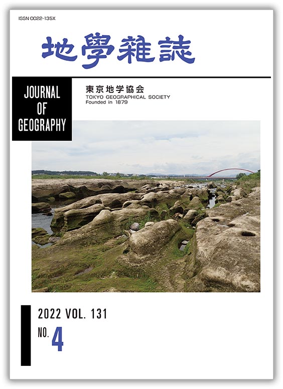
ジャーナル フリー1961年に東京都昭島市,JR 八高線の鉄橋の下の多摩川河床で,アキシマクジラ(Eschrichtius akishimaensis)の化石が発見された.化石は上総層群小宮層(平山層に相当)から産出したもので,前期更新世に少なくとも2つの系統のコククジラ属が生き残っていたことを示唆するという.産出地点の下流に目を向けると,河流に平行する高さ2 m程度の島状の地形が多数発達している.島と島の間の溝は,下流に向かって細長く続く.水位が上昇すれば,島々がまるで牛の群れが泳いでいるように見えることから,小泉(1996)はこれを「牛群地形」と呼んだ.多摩川では,明治時代頃から1968年まで,河床の砂利が盛んに採取された.青梅市から狛江市の間では,採掘箇所は104か所(1963年度末)にも及んだらしい.砂利の採取が引き金となって,おもに半固結の砂層からなる小宮層が露出し,徐々に水流が縦溝を刻み,世界的にも類例の少ない写真の地形が形成された.牛群地形は失われつつある地形で,化石のように残らない,人新世(Anthropocene)の一コマといえる.
(写真・説明:藁谷哲也)
抄録全体を表示PDF形式でダウンロード (2007K)
-
楊 逸暉, 上野 健一2022 年 131 巻 4 号 p. 393-405
発行日: 2022/08/25
公開日: 2022/09/08
ジャーナル フリー山岳域の天候変動を特徴付ける雲・霧・強雨や降雪の発現に関する統計的傾向を明らかにした研究例は日本では少ない。本研究では,長野県菅平高原(標高1,320 m)に設置された現在天気計(バイサラ社)で2010年11月から2020年10月にかけ取得したデータを使用し,視程により区分される霧と靄,降水形態,降雨強度の季節変化・日変化の特徴を明らかにした。靄は霧に比べて高頻度で出現し,両者とも夜間に頻度が増加した。霧は春季・秋季に,靄は夏季に頻度が増加した。これに比べて,長野地方気象台(標高418 m)では,靄は寒候期・早朝に増加傾向が見られた。降雪とみぞれは日中に発生頻度が低下した。みぞれの発生はまれで,12月と3月に南岸低気圧・二つ玉低気圧通過時に出現しやすかった。非常にまれであるが,過冷却水滴が集中して観測される期間が存在した。強い降雨の頻度は7-9月,夕方に増加する傾向があり,中程度もしくは弱い降雨の頻度は6月や10月といった梅雨・台風の卓越する時期に増加した。降雪は強度に明瞭な季節・日変化の違いは見られなかったが,強い強度の割合は南岸低気圧や二つ玉低気圧の通過時に増加した。従来の目視による低頻度の観測に代わり,今回示された高時間分解で長期データに基づく特性は,衛星観測や数値実験の検証データとしても有用となると考えられる。
抄録全体を表示PDF形式でダウンロード (1672K) -
─長崎・西彼杵半島の上部白亜系・古第三系砂岩の砕屑性ジルコンU–Pb年代測定─吉田 聡, 磯﨑 行雄, 中野 智仁, 堤 之恭2022 年 131 巻 4 号 p. 407-425
発行日: 2022/08/25
公開日: 2022/09/08
ジャーナル フリー
電子付録Uranium–Pb ages of detrital zircons taken from seven sandstone samples collected at what were previously called “Paleogene strata” in the Nagasaki and Nishisonogi Peninsula, northwestern Kyushu, SW Japan are measured. Depositional ages of three sandstones in the Nagasaki peninsula are revealed to be e Campanian–Maastrichtian (Late Cretaceous) or younger. Depositional ages of two sandstones in Terashima Island off the west coast of the Nishisonogi Peninsula are likewise dated as Campanian or younger. By contrast, two sandstones in western Nagasaki Peninsula are confirmed as the Ypresian–Lutetian (Eocene) or younger. These new ages are concordant with sporadically reported mollusk fossils, basically supporting the previous stratigraphic scheme, except for a distinct Upper Cretaceous strata called the Mitsuze Formation. The age spectra of detrital zircons from the four Campanian sandstones share the same pattern; i.e., ranging in the Aptian–Campanian with a peak around the Cenomanian. The Maastrichtian sandstone has grains ranging in the Albian–Maastrichtian with a peak around the Turonian, which is slightly younger than that of Campanian sandstones. Judging from the dominance of Middle Cretaceous zircon grains, the main provenances of the sandstones are probably the Ryoke/San-yo and San-in granite belts in SW Japan, where Middle to Late Cretaceous felsic igneous rocks are extensively exposed. The age spectra of detrital zircons in the Campanian–Maastrichtian sandstones are almost identical to those of the Himenoura and Mifune groups in central Kyushu, and the Izumi Group in Shikoku/western Kii peninsula. All of these units were deposited unconformably over the Ryoke granitoids. Within the elongated arc-trench system extending for over 1,300 km from western Kyushu to northern Kanto, Mitsuze Formation sandstones in the Nagasaki-Nishionogi Peninsula mark the known western end of the large-scale Upper Cretaceous fore-arc basin in Japan.
抄録全体を表示PDF形式でダウンロード (5461K) -
南雲 直子, 江頭 進治2022 年 131 巻 4 号 p. 427-445
発行日: 2022/08/25
公開日: 2022/09/08
ジャーナル フリーミャンマーにあるシッタン川の河口には,典型的なロート状の平面形状をもつ潮汐卓越型のエスチュアリーが発達し,大潮の際にはタイダルボアが形成される。本研究では,流れ,土砂輸送および地形の相互関係に着目し,シッタン川のエスチュアリーにおける数十年規模の地形変化のメカニズムを明らかにした。現地調査と,地形図および衛星写真の時系列分析によれば,シッタン川の主流路は少なくとも過去100年の間変動しており,20年程度の周期で右岸と左岸に河岸線の前進と後退を交互にもたらしている。このような周期性は,侵食に伴う滑らかな河岸線の発達と,州の付加および排水路の形成に伴う鋸状の河岸線の発達,および村落分布の変化から説明される。河岸侵食のおもな営力はタイダルボアとそれに続く上げ潮の流れであり,これらが河岸下部を侵食して河岸上部の土塊を崩落させることで河岸線は著しく後退し,土砂はエスチュアリーへと供給されている。このような主流路の移動と河岸線の変化は,流路の蛇行の変化と流路の分岐という2つの素過程によって模式的に説明される。すなわち,河川流と潮汐流の影響下で土砂輸送能力が急激に減少する場所では流路変動が生じる。その結果,タイダルボアのおもな遡上ルートが変わって新たな侵食が起こり,エスチュアリーにおける主流路の移動と河床変動を助長するものと考えられる。
抄録全体を表示PDF形式でダウンロード (7242K)
-
苅谷 愛彦, 原山 智, 松四 雄騎, 清水 勇介, 松崎 浩之2022 年 131 巻 4 号 p. 447-462
発行日: 2022/08/25
公開日: 2022/09/08
ジャーナル フリー
電子付録The geomorphological and geological characteristics, distributions, and ages of block slopes that developed at two alluvial cones (Bentenzawa valley and Okumatazirodani valley) along the Azusa River in the Kamikochi area, northern Japanese Alps, are clarified. These block slopes were believed to be of Pleistocene glacial origin in previous studies. A field survey was conducted, applying microtremor array observations to estimate subsurface geology, and in situ terrestrial cosmogenic nuclide (TCN) dating to estimate age of occurrence. At the Bentenzawa alluvial cone, the block slope is composed of large blocks and lithic fragments originating from heterogeneous igneous rocks, mainly of welded tuff and granophyre, that do not exist in the Bentenzawa valley watershed. Large blocks and lithic fragments of the block slope show clast-supported facies accompanied by jigsaw-crack fracture structures without a fine matrix. A mass of rock blocks fell from a steep wall of igneous rocks around the head of the Okumatajirodani valley, at approximately 2280 to 3090 m a.s.l., on the opposite side of the Bentenzawa valley. Rock slope failure and runout debris flow of blocks are thought to be the principal motions behind the mass movement from the rockwall. Block behavior comprised 3 km horizontal and 1.5 km vertical movements. Blocks were finally transported to the alluvial cone of the Bentenzawa valley to form an opposing impact slope. The results of microtremor array observations suggest that materials of rock blocks about 20 m thick spread and were buried beneath the present riverbed of the Azusa River. The estimated volume of landslide materials is more than 1.1 × 10⁷ m3; age is estimated to be 6900 ± 1000 yrs BP. The Bentennzawa block slope is not of glacial origin. The block slope at the Okumatajirodani alluvial cone consists of large lithic fragments of igneous rocks distributed in this watershed. A mass of rock blocks was supplied by slope failure or debris flow in the Okumatajirodani valley, and was transported and emplaced on the alluvial cone. The volume of the failure is estimated to exceed 2.9 × 10⁵ m3 and its age is estimated to be 900 ± 100 yrs BP.
抄録全体を表示PDF形式でダウンロード (6643K) -
岩橋 純子, 安藤 明伸, 西岡 芳晴, 川畑 大作, 白石 喬久2022 年 131 巻 4 号 p. 463-472
発行日: 2022/08/25
公開日: 2022/09/08
ジャーナル フリー
電子付録A system was created using an exploration-type computer game as the basic material, and its educational effects were verified with the aim of stimulating the interest of students of the digital native generation in the local history of the region. Research classes were conducted using Minecraft (Mojang/Microsoft) teaching materials at Miyagi University of Education Junior High School in Sendai City. The theme of the classes was to convey knowledge about the geology and geological history of the region. Teaching materials were created for students to learn about geological formations in the Kamisugi area of Sendai City, including the region of their junior high school, with the aim of deepening their interest in local geological history and their understanding of the changing earth. A Minecraft world was used with underground strata that reflected information from a geological boring survey conducted in the past at the school, school buildings, and teleportable landscapes of past geological eras, and questions were asked on knowledge of geology based on school textbooks or research papers. The following were confirmed from the research classes at the junior high school. The game using a familiar school as a setting was very popular among the students, and they were not bored by the knowledge questions. The key words of the geological era that the students reached were frequently mentioned in the questionnaire given after the classes. The game is considered to be effective for helping students to understand and remember things visually, while having an enjoyable and positive experience.
抄録全体を表示PDF形式でダウンロード (1360K)
-
小元 久仁夫, 池田 晃子, 横尾 頼子2022 年 131 巻 4 号 p. 473-478
発行日: 2022/08/25
公開日: 2022/09/08
ジャーナル フリーA total of four muddy–fine sand deposits attached to the undersides of cobles and boulders and three Claudiconcha japonica fossils were collected to determine the formation age of conglomeratic beachrock developing at Sasebo, Nagasaki prefecture. The geology of the surveyed coast consists of non-limestone rocks. Radiocarbon dating using Accelerator Mass Spectrometry (AMS14C dating) for the collected samples was conducted to determine the formation age of the beachrock. It was not possible to determine the age of four muddy–fine sand deposits because of their low CaCO3 concentrations (1.4%); however, the Claudiconcha japonica fossils yielded an age of Modern (102.5 ± 0.3 pMC–101.6 ± 0.3 pMC). The elemental composition of the cement samples analyzed with ICP-MS showed Al and Fe concentrations of 6.9% and 4.9%, respectively; however, the Ca concentration was low at 0.6%. The analytical results lead to the conclusion that the formation age of conglomeratic beachrock at Sasebo could not be determined with AMS14C dating, and that cobles and boulders, including mud and fine sand deposits, were cemented with Al2O3 and Fe2O3, or probably with SiO2, and formed conglomeratic beachrock.
抄録全体を表示PDF形式でダウンロード (1343K)
- |<
- <
- 1
- >
- >|